Mining Memories: The Silent Sentinels of Vulture City Picture of the Week - Vulture City, Arizona

Headframe: Vulture City's towering relic from its mining past
Mining Memories: The Silent Sentinels of Vulture City – Dive into Vulture City’s history, and you’ll discover mining relics, quirky tales, and even pumpkins with legs. Your unexpected desert journey awaits!

Hello again from Vulture City, where the unexpected is just another Tuesday! As I’ve continued my explorations here, I uncovered stories hidden in the shadows and surprises around every corner. I have butterflies in my stomach, and I can’t wait to tell you that I was right about those menacing pumpkins—but let’s talk about this week’s photo first, and then we’ll get to the paranormal.

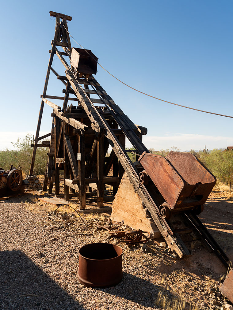
Leading the tour today, we’re craning our necks to take in a lofty structure known as a headframe. No, it’s not the latest in chiropractic care; it’s an essential tool in mining. Headframes served as the backbone (pun intended) of many mines, hauling not just ore but the brave souls who ventured deep underground. While the exact inventor of the headframe remains a debate for the history books, these mechanical marvels evolved from humble hand-powered origins to the might of steam and electric prowess.

In our arid southwest, standing headframes are rarer than rain. Given that lumber had to journey to these barren expanses, and the indigenous trees weren’t quite up for the task, it’s hardly surprising. The smaller mines often skipped the theatrics, as their digs weren’t exactly the stuff of Jules Verne novels. However, tread cautiously if you’re trekking across the desert and spot one (or just heaps of sturdy wood)! There’s likely a yawning chasm lurking beneath.

The sentinel at Vulture City isn’t the grandest I’ve encountered, and it’s been repositioned away from the original mine shaft. I surmise it’s a safety maneuver to stop kiddos from taking unplanned trips down under—after all, youngsters aren’t toast. They don’t pop back out when they’re done. With its singular pulley setup, this headframe likely relied on sturdy equine muscle power. Imagine that—an equestrian gym session! These timber titans might be mute but resonate with tales of grit, ambition, and underground treasures.

When I thought Vulture City couldn’t get any more bizarre, the town proved me wrong. As I walked through the displays, I saw one building marked with a Brothel sign. Of course, I had to check it out because—that’s the kind of guy I am. I expected to see an excellent museum-style exhibit featuring swanky furniture and feather beds covered with hand-made quilts. You know, the usual dust-covered stuff. But what did I find when I walked into the Brothel’s waiting room? Three pumpkins casually lounging on the sofa, arms and legs crossed, discussing the weather (I presume—I don’t speak pumpkin). But the moment they saw me, it was like I’d flipped on the lights in a New York City apartment at midnight—those pumpkins scattered faster than… well, pumpkins with legs!

Three orange clients spending their free time looking for social media.
Ghostly Gourds: An Unexpected Brothel Encounter – You’ll never know who’s already in line when you unannounced into a brothel’s waiting room.

I was lucky that I already had my camera at the ready. I was able to squeeze off one clear shot before all of that dust was kicked up. They scattered in different directions so fast I sprained my eyeballs tracking them. You see—I was right about these pumpkins, and unlike the fuzzy Sasquatch photos you see in the check-out counter rags, this one’s sharp as a tack.

As we inch closer to the spookiest day of the year, keep your camera ready, and more importantly, keep a wooden stake and garlic clove nearby! Who knows what might be lurking around the next corner? If you’d like to examine the headframe closer, it’s on my website (Jim’s Web page) and a page at Fine Art America (FAA Link). Join me next week as we conclude our Vulture City voyage and, fingers crossed, solve the pumpkin enigma.

Till then, keep your spirits high and your humor dry!
jw

Techniques: The Art of Capturing the Unexpected

The most mesmerizing snaps in photography often arise from serendipity—like those jaw-dropping space launch vistas captured by eagle-eyed air travelers. Hence, when queried about the best camera, I quip, “The one you’ve got handy,” which, nowadays, is probably your phone.
Photography, much like life, is peppered with unforeseen marvels. Whether it’s anthropomorphic pumpkins or whimsical backdrops, mastering these fleeting instances demands foresight and improvisation. Here’s my toolkit for seizing the spontaneous:

• Stay Vigilant: Your camera should be an extension of your arm. Magic rarely sends an RSVP.
• Opt for Rapid Shutter: The key to pinning down swift, fleeting moments in pristine clarity.
• Experiment with Perspectives: An unusual viewpoint can accentuate the oddities of a scene.
• Keep a Cool Head: When faced with the unexpected, breathe, tweak, and click.
• Welcome the Unscripted: Don’t shun the anomalies; let them enhance your photographic narrative.

Remarkable snapshots often sprout from impromptu events. So, let spontaneity be your muse, and you might clinch that once-in-a-lifetime frame.

BTW:

I just added another YouTube video to my On the Road series. This one covers my Arizona Mountain Portfolio. If you’d like to watch this six minutes of eye candy, you can see it here: https://youtu.be/pN0dbZ2tBj8

Marble Memories: Tale of the Gadsden Hotel’s graceful stairs Picture of the Week - Douglas, Arizona

Marble Memories - Immerse yourself in the timeless elegance of the Gadsden Hotel's grand marble staircase, inviting you to step into a world of architectural splendor.
Marble Memories – Immerse yourself in the timeless elegance of the Gadsden Hotel’s grand marble staircase, inviting you to enter a world of architectural splendor.

Welcome to our wrap-up of May’s Orphan Photo Project. I hope you’ve been enjoying the show so far. This week’s episode takes us back to Cochise County and the border town of Douglas. Like several towns along our southern border, it has only a quarter of the population of its southern sibling—Agua Prieta. Unless you’re on a mission to score some cheap Kahlua, mescal, or prescription drugs, there are not many reasons to go to Douglas, but a stop at the iconic Gadsden Hotel is one of them.

Yes, I have uncovered another grand hotel from Arizona’s mining days—so indulge me. It was built at the turn of the 20th Century by mining corporations to satisfy old fat cats that traveled here to inspect the books. They couldn’t be expected to sleep in tents like the commoners they paid. These tycoons needed a place to smoke cigars and sip cognac while stuck in the wild.

The Gadsden Hotel’s architecture reflects the elegance and grandeur of the time, with its ornate facade and intricate details. It was designed to provide a luxurious experience for its guests, offering luxury accommodations, fine dining, and entertainment. It was among the first to provide in-room toilets, fresh air ventilation (yes, that sounds like open windows to me, too), and an elevator that stopped on each of its floors. Today, I’m not going to waste time gushing over this fabulous hotel; I’d rather gossip about some of its guests. That’s where all the fun is.

In the early 1900s, during the tumultuous Mexican Revolution, battles often spilled over into the border towns of Arizona. Douglas was no exception. One day, as the sounds of gunfire echoed through the streets, the guests of the Gadsden Hotel sought refuge on the rooftop to witness the spectacle. Among them was the notorious revolutionary leader, Pancho Villa.

In an audacious display of bravado, Villa rode his horse into the hotel and galloped up and down the magnificent staircase that graces the lobby. The clatter of hooves and the cheers of onlookers reverberated throughout the grand halls, creating an unforgettable moment in the hotel’s history.

Legend has it that the spirited Villa, with his characteristic wide-brimmed hat and commanding presence, left a lasting impression on the staff and guests who witnessed this daring act. It became a story that would be told and retold, forever etching Villa’s name into the annals of the Gadsden Hotel. Today’s Gadsden visitors still search for a legendary chip in the white marble.

You want to know what I think. I think Pancho got bored fighting with the Federalies in Agua Prieta and decided to take a break. He rode across the border to enjoy a frozen Margarita at the Gadsden bar—after all; it was May 5th. When the bartender tried to explain that the Margarita hadn’t been invented yet, Pancho went ballistic. He went outside and untied his horse— Siete Leguas—from the parking meter and road back inside in an attempt to trash the place. You know, rock stars. That’s what they do.

In the 1920s, famed radio evangelist Amy Semple McPherson captured the nation’s attention with her charismatic preaching and healing services. However, her life changed dramatically when she mysteriously disappeared from Los Angeles. Authorities launched a widespread search, and the public anxiously awaited any news of her whereabouts. Eventually, Amy reappeared in Douglas—of all places.

There were conflicting accounts and rumors surrounding Amy’s disappearance and reappearance. Some sources suggested that she was kidnapped and held for ransom, while others speculated that she had run off with a lover to a secluded location. According to her account, she claimed to have been abducted and held captive. My legal staff told me there is no historical evidence to put Amy inside the Gadsden, but after being released from the local hospital, where else would someone with all that wealth and fame stay—it certainly wasn’t the YWCA.

The Gadsden Hotel has welcomed several less controversial personalities throughout its history. Among them, aviator Amelia Earhart graced the hotel with her presence during her visits to Douglas in the 1930s. The iconic actor John Wayne frequented the Gadsden Hotel in Arizona. Presidents Franklin D. Roosevelt and Lyndon B. Johnson also left their mark on the hotel during their travels in the Southwest. These visits, spanning different eras, have contributed to the Gadsden’s rich history and enduring allure.

A Glimpse of Grandeur: The Gadsden Hotel's Captivating Facade - Behold the captivating exterior of the Gadsden Hotel, a timeless landmark that exudes elegance and preserves the rich history of Douglas, Arizona.
A Glimpse of Grandeur: The Gadsden Hotel’s Captivating Facade – Behold the captivating exterior of the Gadsden Hotel. This timeless landmark exudes elegance and preserves the rich history of Douglas, Arizona.

We hope you’ve enjoyed hearing the fascinating Arizona stories as we end our journey through May’s Orphan Photo Project. As usual, you can see the larger version of Marble Memories by following this link to the web page: (https://www.jimwitkowski.com/newWork/gadsdenStairs.html). As we bid farewell to the Gadsden Hotel, we invite you to join us next week when we embark on a new adventure. Until then, thank you for joining us on this journey, and Queen Anne and I can’t wait to share more with you soon.

Until next time
jw

Technique

Capturing the essence of Gadsden’s famous staircase presented a unique challenge. Instead of the typical head-on view, I wanted to emphasize the polished marble steps and the potential hazard they posed to Pancho Villa’s horse, Siete Leguas. To achieve this, I opted for a wide-angle lens and positioned myself low at the left side of the marble waterfall, shooting upwards towards the bank of stained glass windows. The dim lighting inside the Gadsden lobby required a higher ISO of 2500, and I stopped down the lens to f/6.3 to ensure everything was in focus. I captured a handheld shot at 1/15th of a second in the low light conditions. Remember to hold your breath to minimize camera shake in challenging situations like this.

Arlington’s Abandoned Feed Mill: Fading Memories of Cattle Country Picture of the Week - Arlington, Arizona

Abandoned farm equipment at Arlington Cattle Company
Arlington’s Abandoned Feed Mill – The abandoned grain hoppers and silos of the Arlington Cattle Company were left to rust in the Arizona desert.

Last week, I wrote about the exceptional rainfall we had in Arizona and how the wildflowers love it. Well, the same wet winter that showered our land with nature’s colorful confetti also brought heavy mountain snowfall. Since the predicted snowmelt and runoff would overflow our reservoirs, the Salt River Project began releasing water into the river. It’s been quite a while since we have had water in our ordinarily dry riverbeds. While some may scoff at the idea of water in Arizona’s riverbeds, I was thrilled that I might get the chance to shoot some whitewater rapids in the desert.

I convinced Queen Anne to go-for-a-ride(?) a couple of weeks ago. We drove down the west valley to the Gillespie Bridge, excited at the prospect of capturing the raging torrents of water. However, upon arrival, we were met with disappointment. The river was spent and lethargic when the artificial flood passed through Phoenix. The snowmelt’s aftermath left us with sluggish, murky water oozing through the tamarisk. It looked more like effluent than a river. Feeling disheartened, we started to return home when I noticed the stunning light falling on the machinery at the Arlington Cattle Company. When I stopped the car and grabbed my camera, Anne responded, “Hurry up! I’m Starving.”

The Gila River begins its journey in New Mexico’s Gila Mountains. It collects water from its tributaries, including the Salt River, the Verde River, the Santa Cruz River, the New River, the Agua Fria River, and the Hassayampa River. The Gila River embarks on an audacious westward journey, carving its path through untamed landscapes. Just after the confluence of the Gila and Hassayampa rivers, the Gila turns south for thirty miles towards Gila Bend. As the river flows past the Buckeye Hills, it enters a natural pinch point several miles down old US 80. It passes between a formidable silhouette of a volcanic sentinel and the edge of Gillespie Shield Volcano. The black rock lava flow rises two or three stories above the road and river and is known for its impressive pictographs, visible along the cliff of lava rock when examined closely. At this pinch point, pioneers attempted to build three versions of the dam. After they all failed, the highway department erected an all-season bridge to cross the river. Local farmers plant the dam’s old flood plains in summer with deep green cotton, making the little valley a desert oasis.

I’ve been to the Arlington Cattle Company before, so this wasn’t my first time photographing this abandoned equipment. The last time I photographed there was over a decade ago; the massive boom that sent grain over the road to the feed lots there had collapsed into the canal flowing along the roadside. Someone has cleaned that mess up since then. As I stood and framed the shot, I could hear the ghostly sounds of machinery banging, gears meshing, and belts squealing in protest. The equipment stands as a testament to the relentless march of time, bearing the scars of decades past, with the weathered vestiges of industry adorned in hues of faded silver and rust contrasting against the intense blue sky. However, what catches my eye in this photo is the tall silver elevator, which towers above all else, and with the sun’s reflection, it appears as a beacon against the bright blue sky. The wispy white clouds in the background are a bonus and provide a nice contrast to the earthy tones of the equipment.

The Arlington Cattle Company was established in the early 1900s by a group of investors led by William W. Clemens, who also served as the company’s president. The company purchased approximately 55,000 acres of land in the Arlington Valley and constructed a state-of-the-art cattle feeding facility. The company aimed to fatten cattle for the market using a combination of locally grown grains and hay from nearby farms.

The facility stood as a cathedral of innovation, a testament to the audacity of human endeavor, featuring a grain elevator that could lift and store thousands of bushels of grain at a time. The elevator was powered by an extensive motor and conveyor system that could move the grain from the elevator to the various silos and feedlots throughout the property. The company also built a vast network of canals and irrigation ditches to ensure a reliable water supply for the crops (and cattle).

Despite the initial success of the operation, the Arlington Cattle Company struggled to turn a profit. The company faced several challenges, including drought, floods, and fluctuations in the price of beef. In addition, the company’s location in a remote part of the state made transportation difficult and expensive. As a result, the company was forced to declare bankruptcy in the early 1920s. After the default, the land and equipment were sold to various buyers. Today, the rusting equipment seen along the roadside in the Arlington Valley are the only remnants of the Arlington Cattle Company.

Rustic Gillespie Bridge spanning the Gila River with a mountain in the background
Old US 80 Bridge at Gila River – The historic Gillespie Bridge at Gila River, part of Old US 80, features a rusted iron truss structure and spans over the water with a volcanic rock mountain in the background.

I hope you enjoyed this week’s photo and reading about the Arlington Cattle Company and the old farm equipment that still represents Arizona’s ranching history. Don’t forget to check out the larger version of Arlington’s Abandoned Feed Mill Cattle on our website by clicking here. Join us next week for more fascinating stories and photos of farming equipment, from the old to the new. And who knows, maybe we’ll even find something borrowed and blue. Thanks for reading!

Till next time
jw

Bel Air at the Gulf Station Lowell, Arizona

Bel Air at the Gulf Station - a 1957 four door Chevy Bel Air waits for gas at the Gulf Station in Lowell, Arizona.
Bel Air at the Gulf Station – 1957 four door Chevy Bel Air waits for gas at the Gulf Station in Lowell, Arizona.

My lifelong love affair with cars runs so deep I’m sure I was born wearing aviator sunglasses and a pair of black Italian leather driving gloves—the kind with knuckle holes. My earliest memories are of toy cars from my parents, the countless scale model kits I built in my room, and the peddle car I had when we lived on the steepest hill in Pittsburg. At age five, I learned to drive it with my feet off the peddles so it could go faster. I held on for dear life and eventually got around the corner at the bottom without lifting (for the uninitiated, that means not scuffing your shoes along the sidewalk). Of course, even then, I complained about the dreaded push back up the hill.

My dad and Uncle Bunny (Yeah, that’s right. His real name was Charles, but everyone called him Bunny) came home one Saturday when I was thirteen with a beater 51 Ford sedan. It was less than ten years old but already considered junk. Dad proclaimed, “If you can fix it, you can have it.” He handed me a pair of pliers and a flathead screwdriver. I had no mechanical training and no idea what to do. After unsuccessfully trying to remove one of the head bolts from the old flathead V8, I gave up. The coupe sat silently in our garage for years.

I did find a use for it eventually. One day I was walking in our alley from school when I spotted a trash can overflowing with Playboy magazines. I don’t know who threw them out, but it was a gold mine for a 13-year-old. I scooped up as many as I could carry and stashed them in the back seat of my Ford when I got home. My little friends and I spent countless hours pouring over those articles until we wore out the magazine staples. I suppose that’s when my dirty old-man training began.

I guess that’s why I’m so delighted to find a place like Lowell and its open air museum showcasing things from my past. For example, when I look at this week’s picture—called Bel Air at the Gulf Station—I see the 57 Chevy and remember cruising through Bob’s Big Boy in a 58 Ford my cousin drove that dad bought us. Clydie would pull a couple of plug wires off, so it had a loping idle. It didn’t bother him that the car reeked of unburned fuel or that the guys with real hot rods were wise to his scam. It was Clydie’s moment in the sun. There are so many stories about that 58 and my cousin Clydie it would fill a whole chapter in my autobiography.

We never had Gulf or Sunoco gas stations on the west coast. Our premium gas was Chevron Supreme. I became a fan-boy when Gulf sponsored the winning Fords and Porches at Le Mans. If there were a Gulf station within a hundred miles of my house, I would have gone out of my way to fill my tank. Unfortunately, Gulf Oil merged with Standard oil in 1986, and their stations are now Chevron and don’t sponsor racecars. Maybe that’s why there is a Chevron sign on the orange building, which otherwise seems out of place.

I feel there are a couple of errors in this presentation. The first is that Chevrolet is a four-door, and no self respecting greaser would own a four-door. Even our friend Fred once owned a 2-door (maybe he’ll share a photo with us). However, 57 Chevy’s are the pinnacle year for collectors, and they have cherry-picked them off the market. I doubt that there are any more hiding in barns somewhere in America.

The other error is a Pepsi and 7Up machine, but not a Coca Cola box. Unless you lived in Utah, no one drank anything other than Coke. Long before In-N-Out, Bob’s had a gorilla menu, and you could order a Coke with a shot of vanilla or cherry flavor. I knew all of that hip stuff.

You can see a larger version of Bel Air at the Gulf Station on its Webpage by clicking here. There’s more to see along Erie Street, so don’t forget to come back next week for another story.

Till next time
jw

BTW:

There is a gold star waiting for the foreheads of anyone —except for Fred—who can tell where the gas went into a 1957 Chevrolet.

Past and Future Picture of the Week

Past and Future - Along Willcox's historic Railroad Avenue, there are business that pay homage to the town's past and its future.
Past and Future – Along Willcox’s historic Railroad Avenue, some businesses pay homage to the town’s past and others to its future.

My dad bought our first television the week they hit the stores from stories that my mom told. I don’t remember because I was an infant at the time. The screen was small; you could cover it with your hand. She said that news of our new set spread fast, and the entire neighborhood crowded into our two-room apartment to watch shows on it. The crowd size amazes me because my great-grandmother’s apartment building didn’t have indoor plumbing, but it must have had electricity.

We didn’t need a TV Guide. We memorized the program schedule and could rattle off the shows for any given evening. The best night was Sunday. That was the night that Walt Disney’s Disneyland came on. They called it that between 1954 and 1958, it had various names after that. The gist of the show was always the same. Us kids loved that we could stay up an extra hour to see it—and maybe some of the Ed Sullivan Show if Topo Gigio was a guest.

The Disney show had four rotating themes. My siblings and I liked the cartoon week the best, but my dad enjoyed the westerns. They were either cowboy stories or a smooth-talking narrator explaining the west. He spoke differently from us. He didn’t have an accent as such—he had a drawl. He hung on to words so long they curled at the end—like the top of a Dairy Queen cone. His calm voice was soothing, and even at our young age, we knew that he wasn’t from Pittsburgh.

As I got older, I learned that the narrator’s name was Rex Allen. In addition to the Disney shows, he was an actor, songwriter, and singing cowboy. You may remember seeing his movies on Saturday morning cowboy shows if you’re as old as I am. (I don’t see a lot of hands out there in the peanut gallery, so you’ll have to take my word for it.)

After seeing this week’s picture, many of you have already guessed that he was born and raised in Willcox. I suspect that he’s their most famous native, and that’s why there is a museum for him along Railroad Avenue, across the street from a park with his statue. I can’t imagine anyone loitering in that park because the busy railroad tracks bisect it. It’s no place for a drunken hobo.

The tan building in the photo wasn’t built to house the Rex Allen Museum—it was initially the Schley Saloon. Sound familiar? It was the bar where Joseph Schwertner made his money—go back a read last week’s story. Two doors down, the building with the blue awnings is the Marty Robbins Gift Shop. You’re asking, “What’s he got to do with Willcox?” If you’re a boomer like me, you’ll remember the hit song Streets of Laredo that Robbins sang. Rex Allen wrote it. I think another Allen song that Arthur Godfrey recorded in 1948 is pretty catchy. It’s titled Slap Her Down Again Paw. It’s true; I couldn’t make this one up.

The grand white building between the museum and gift shop was a bank. It’s currently the Keeling Schaefer wine tasting room. One of at least three that Queen Anne and I saw on the avenue, and they may be the future of Willcox tourism. While the memory of Rex Allen and Marty Robbins appeals to my generation, there is no context for those that follow. So, the old cowboys’ draw may be on the wane.

However, wine is another story. A couple of decades ago, some adventurous vintners settled into the high grasslands of southeast Arizona. They saw that the conditions here would be an excellent place to plant vines—especially the well-drained soils of the foothills. The climate and geography are similar to parts of California’s central valley. New wineries are blooming from the little town of Elgin east to New Mexico.

Anne and I spent a couple of hours in Keeling Schaefer sampling and talking with the hostess. We found their offerings to be young and a little rough, but we did like a couple of whites and reds enough to purchase. There is an essence of the local soil in the wine—like the peat in a highland scotch. It’s a characteristic that you like or not. A word of advice if you go; sample at the tasting rooms and note your likes. Then stop at Safeway and buy the bottles at a more reasonable price.

You can see a larger version of Past and Future on its Web Page by clicking here. Next week we move on to a new project. Come back and see our next project.

Until next time — jw

Willcox Depot       Picture of the Week

Willcox Depot - The old train depot in Willcox is now used as the town's city hall.
Willcox Depot – The old train depot in Willcox. The local government now uses it for city hall.

Queen Anne and I traveled to Arizona’s southeast corner this week. One of my future projects is in Cochise County, so we spent a couple of nights in Willcox. The eastern half of the state is unlike where we live. That desert has little cactus. Instead, you see blue mountain ranges rising from the 4000′ elevated broad yellow grass-covered valleys and a couple of dry lakes—or Playas, as the Spanish-speaking people call them. This area shows the geographic diversity of Arizona.

It’s almost over, but it’s still winter, which means it’s still snowbird season, so we skipped seasonal rates at the chain motels near Interstate 10 and opted for a cheaper inn closer to town. The original builders probably built it in the 60-70s, but the current owners work hard to keep it clean and contemporary. Our room had a fresh coat of white paint, new blond fake-wood floors, and a useless bright red sash across the foot of the bed. We could watch long freight trains race past on the Southern Pacific tracks from our window. Three or maybe four of them an hour.

Although the throbbing bass from its five engines was enough to vibrate the bed across the linoleum, the trains didn’t keep us awake. That’s because they never slowed or blasted their horns at the town’s only track-crossing. However, we did have an issue with the new stylish duvet cover. It wasn’t like the plush down-comforter that we have at home. We hit town in-between storms, so the nights were clear and cold—below freezing. We tried to heat the room using the window-air conditioner, but every time it cycled on, it was the equivalent of a DC3 engine starting next to the bed. We finally shut it off and slept closer to one another.

Another amenity missing in little places like these was in-room coffee. I can’t function without my morning java. So, I’d get dressed and venture out to secure my fix at first light. In the golden light, I searched the town for a coffee house. Not only did I find one, but I also discovered a neat little mom-and-pop bakery and the Willcox historic district. Since I had hours to kill while I waited for Her Majesty to prepare herself for public viewing, I wandered the eight blocks with coffee in one hand and camera in the other. After a couple of mornings, I had enough images to decide that March’s project would be about Willcox.

If you drive through Willcox on Interstate 10, you won’t see much—only the usual chain motels and burger joints located at the mid-town exit. Even if you drive through town on the freeway bypass, you’ll pass some old motels, a couple of RV parks, and a gas station or two. There are many closed businesses along the road. The exciting stuff is on Railroad Avenue—next to the tracks because Willcox was built by and for the Southern Pacific Railroad.

Long-time readers may recall that the early steam engines ran on fuel and water. Willcox Playa—a seasonal lakebed—is conveniently located midway between El Paso and Phoenix, so Southern Pacific built a whistle-stop there in 1880. The company dubbed the town Maley. It was a single-purpose town for nine years when a guy, General Orlando B. Willcox, got off to stretch his legs and realized that it would be a fabulous place to raise cattle.

Willcox wasn’t even on a significant highway until the Feds completed Interstate 10 in 1960. Before that, the southern Coast-to-Coast highway was US 80. It went south around the Chiricahuas to Douglas and then Tombstone.

This week’s picture directly relates to the railroad birth of Willcox. It’s a shot of the train depot located at the heart of old-town. It’s a large building for a small town and in pretty good shape, considering the railroad closed the depot years ago. Today the trains race past at full speed and don’t even blow their horn. It’s now the town’s city hall. I liked how the pyramid pattern repeats from the turret to the roof peaks. I called this image Willcox Depot.

You can see a larger version of Willcox Depot on its Web Page by clicking here. Next week, I’ll show you another location I shot during my Willcox wanderings.

Until next time — jw

White Bluff Picture of the Week

For most of the 1200 miles between Oklahoma City and Barstow, Route 66 and Interstate 40 are stuck together like a zipper. As you drive along the freeway—started in 1957 and completed in 1984—you can see a ghost of the old mother road on the roadside. Sometimes it’s a frontage road with little traffic, in different spots the pavement is gone, and it’s not a road at all.

Arizona has two exceptions to these overlying trails. The first is where Interstate 40 cuts off Peach Springs between Kingman and Seligman, and the second is between Kingman and Needles. In the first case, the freeway cuts miles off the trip by heading straight across country, while the latter deviation is further (albeit quicker) as it skirts the Black Mountain Range.

The section of the historic road that Queen Anne and I explored this month cuts through a mountain pass that Captain Lorenzo Sitgreaves mapped in 1851. Although the trail has beautiful scenery for me to photograph, it is very twisty and slow going, and that’s not ideal for interstate commerce.

Cool Springs Station - A historic gas station converted to a gift shop that now sells hot dogs from a cart.
Cool Springs Station – A historic gas station converted to a gift shop that now sells hot dogs from a cart.

After we finished photographing Thimble Mountain seen in last week’s post, we continued along the road for less than a mile, where we stopped at an old gas station called Cold Springs. The owners have converted it into a gift shop that sells nostalgic Route 66 kitsch, but there were no customers. As I snapped a few pictures, a woman’s voice came from the shadows, “Hello there. How ya doin’?” When I took off my sunglasses, I saw a young woman sitting in the shade next to a hot dog cart. We made small talk, and I asked about her business. “April is normally our best month, but this year it’s a bust.” After promising not to include her in my photos, I took another shot or two before we drove away. Looking back, we should have bought our dinner there. She could have used the money, and her food was probably better than the drive-through meal we got at the Kingman Carl’s Jr.

As we drove further, we had to stop almost immediately again, where the canyon narrowed. On the road’s north side was a pair of sandstone bluffs rising from the dry creek bed. Their cliffs glowed in the late afternoon sun, so of course, I had to capture the moment on film … er, I mean electrons. I’ve since found out that at this location, the road passes between two wilderness areas. To the north is the Mt. Nutt Wilderness, while on the road’s south side is the Warm Springs Wilderness area.

White Bluff - The vertical sandstone cliff of a bluff provide a great home to nesting swallows.
White Bluff – The vertical sandstone cliff of a bluff provides a great home to nesting swallows.

In this week’s featured image—called White Bluff—you can see Mt. Nutt in the distance. At over 5100 feet it is the tallest peak in the Black Mountain Range. To get any closer, you’ll have to hike or grab one of the local wild burros—of which there are many—and ride.

You can see a larger version of White Bluff Butte on its Web Page by clicking here. I hope you enjoy it. Next week, we’ll travel over the pass and make a stop in Oatman. I hope you’ll join us then.

Until next time — jw