Mud Arch Picture of the Week

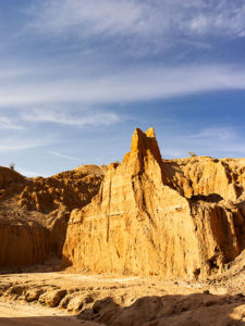
Continuing last week’s adventure to the mud cliffs at Alamo Lake, I took this week’s picture at the other end of the slot canyon. It’s not a very long hike—maybe fifteen minutes if you don’t dawdle—but I was exploring with a camera and stopped to take pictures often along the route. The reward waiting for you at the canyon’s head is this mudstone arch carved by rushing water draining from the surrounding mesa. If you hike a few yards beyond the arc, the canyon ends, and you’re on the mud flats between Date Creek and the Santa Maria River. The water is runoff from the Black Mountains in the north that has carved the canyon from the flats.

Mud Arch
Mud Arch – At the end of a short hike up the slot canyon is a mud arch as a reward for your effort.

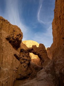
Since I’m not a geologist, I can’t tell you how old the arch is, but because the surrounding soil quickly erodes and because I slept in a Holiday Inn Express once, I assume that it hasn’t been there for very long—geologically speaking—and it may soon crumble. You’ll notice that the arch’s shape isn’t smooth and rounded like the sandstone arches in Utah, which tells me it hasn’t been polished by blowing wind. That’s another clue to its relatively young age. I won’t be surprised if it disappears in less than a decade.

When I arrived on this scene, the sun was low enough that it didn’t shine onto the canyon walls, but it did add that late afternoon glow to the mound behind it and separated the arch from the background—sort of a spotlight, as it were. With streaky clouds in the sky … what more could a photographer ask for?

You can see a larger version of Mud Arch on its Web page by clicking here. I hope you enjoy viewing my newest entry and tagging along for the other canyon shots I’m revealing this month.

Until next time — jw

Bat Ears Picture of the Week

A couple of weeks ago, I drove to a part of Arizona that I hadn’t seen before. I knew about Alamo Lake as a fisherman but never went there because it wasn’t stocked with trout, and the fishing reports always warned about rattlesnakes. That was enough to put me off. But, during our club’s spring classes, one of the students brought in photos from the Alamo area that I found so interesting that I changed my opinion about visiting the La Paz County lake.

She took photos east of the lake, where Date Creek cuts through an ancient mud deposit. Because of how the intermittent water has eroded the soil, the place is known as Mud Cliffs. It’s not shown on any maps I have, but I knew it was the general area, so I left the house with enough time to explore and still have a couple of hours to shoot before sunset.

From Wenden, the paved road to Alamo State Park runs due north. It has little or no traffic, and it only took me an hour to get to the park store. When I asked the friendly staff inside about the cliffs, the host handed me a hand-drawn map. “Head toward Wenden to the Wayside Road, then jog over to Palmerita Road and follow it north.”

“Thanks,” I said as I took the map and paid too much for a Butterfingers candy bar and the park’s day fee—even though I was leaving.

During the classes, my student said her group was out on ATVs, but she believed you could get there by car. She was right. All the roads were wide and well-graded, and when I drove them, they didn’t have a lot of washboards. After I reached the spot on the map, I searched for the canyon shown in her pictures, and when I found it, I spent an hour or so hiking and shooting the photos that I’ll be sharing this month—I guess it’s Alamo Lake Month.

Bat Ears
An erosion formation at the head of the slot canyon glows in the late afternoon sun. The pair of points on top reminded me of a bat or maybe even Batman.

This week’s image is called Bat Ears, and I took it at the slot canyon’s mouth towards the end of the day. I passed it going in, but the sun didn’t have the same warmth as in this image, so it wasn’t interesting enough to shoot. The name comes from the pair of points at the top. This cliff doesn’t have a name—none of them do. Because the soil is so soft, it quickly erodes. A good flood will wipe out the existing landscape and replace it with new formations. The ears may not last another year, so I got to name a geological feature that—maybe—no one else will see. My chest swells with pride.

You can see a larger version of Bat Ears on its Web page by clicking here. I hope you enjoy viewing my new entry, and I hope you’ll tag along as I work my way up the canyon. It’s a pretty exciting hike.

Until next time — jw