13 Mile Rock Picture of the Week

Just thinking about road construction gives me a headache. I’ve had too many bad experiences traveling across the country. Don’t get me wrong; I know that roads need maintenance. Besides, I love driving on fresh pavement. It’s just that I’ve frequently gone across Arizona, New Mexico, and Texas in construction zones 10 or 20 miles long without any working crews. Inevitably, I’m stuck behind a Walter Mitty who’s afraid to drive over 25 when there are orange pylons on the road, and a close-up view of a Peterbilt 379 grill looming in my rearview mirror.

So, it’s hard for me to imagine a crew building a road—or in the case of General Crook, a trail—through pristine wilderness. It took them two summers to complete. During the first year, C.E. Cooley, Henry Dodd, and some troops from Fort Apache laid out the route to Fort Whipple. As a side note, this was the legendary trip where an Arizona town got its name. While camping in a White Mountain meadow, the men played a game of cards (I guess they couldn’t pick up a Wi-Fi connection for their iPhones), with the loser having to clean the evening’s dishes. The camp is now the town of Show Low, Arizona.

The second summer, a cadre of troops protected a construction team as they spent several months building a road wide enough to get wagons through. Imagine having to move rocks, clear downed logs, and building grades without a bulldozer. And even with all that hard work, their Yelp reviews sucked.

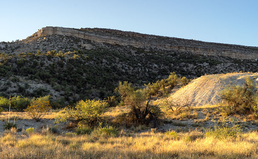
With each mile of progress complete, the construction crew left a marker, either carved into a tree or stone. Some of those markers are still there. The easiest to find is Mile 13 because the State has installed a historic plaque and turn-out on the south side. At mile 13, the road begins its ascent from the Verde Valley up the Mogollon Rim. It is east of the Fossil Creek road beside a large butte called 13 Mile Rock Butte.

13 Mile - From 13 Mile Rock Butte looking back down at the Verde River Valley, you can see all of the way to the Black Hills, which are on the far side of the river.
13 Mile – From 13 Mile Rock Butte, looking back down into the Verde River Valley, you can see all of the ways to the Black Hills, which are on the far side of the river.

This spot is where we stopped to take this week’s featured image. And I have to say that the view from there is pretty good. From above the Sycamore Canyon Ravine (5,000 ft elevation), you can see back down into the Verde River Valley. In the middle distance is about where the Fossil Creek Recreation Area is. Along the distant horizon is the Black Hills, which marks the Verde Valley’s south wall. Behind the knoll in the frame’s center, the Verde River turns south and becomes a designated Wild River from there until it empties into Horseshoe Lake near Carefree.

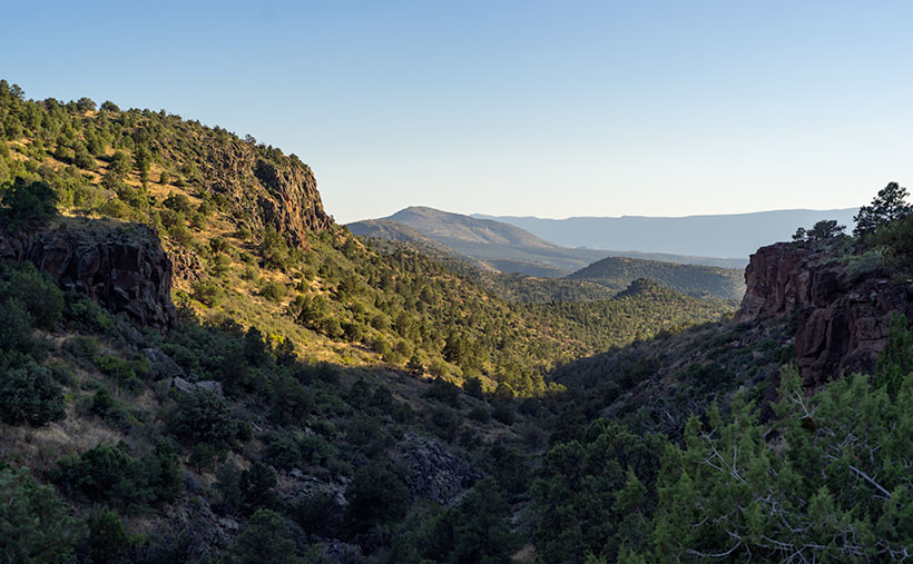
You can see a larger version of 13 Mile on its Web Page by clicking here. Be sure to come back next week and see where we stopped after reaching the top of the Rim.

Until next time — jw

Verde Limestone Picture of the Week

For centuries the Verde River Valley has been a peaceful home for many peoples. It makes sense because the Verde River flows year-round, even in times of drought—as we have now. The green waters of the Verde—Spanish for green—flow between the Black Hills (Mingus Mountain) on its south-west flank and the Mogollon Rim to the north-east. The river runs from Chino Valley to Fountain Hills—170 miles. It collects the runoff water from the rim via its tributaries like Sycamore Creek, Oak Creek, Beaver Creek, and West Clear Creek. Although the river bottom is a dense cottonwood forest, its flood plains are perfect for growing corn and squash.

There are many sites of early inhabitants along its length, but the best known is the pueblo of Tuzigoot—built by the Sinagua people in the 10th century. They only lived there for a couple of centuries before moving on. The next settlers to arrive were Apaches—Canadian migrants that were chased off the plains by the Sioux. The various bands of Apache established homes along the transition zones across Arizona and New Mexico. They weren’t aware that their new landlords were the Spanish, who were mostly interested in saving their souls and stealing their gold. For the next 300 years, life in the Verde River Valley was peaceful.

Then one day, in 1821, there was a knock on the door—er, teepee flap. It was a government man. He was there to inform one and all that they were Mexican citizens now and, by the way, do you have money to chip in for our new country?

After that, things began to happen fast, and life seemed to go downhill quickly. A mere 30 years went by when another man rode up on a horse, shook a bunch of hands, handed out flyers, and declared, “Welcome to America.” The very next year, Californians discovered gold, and easterners clogged up the trails rushing to get to it. Some got rich, but most of them didn’t get to the Golden State in time, so they made their way back and decided that our valley would be an excellent spot for a farm. There was a civil war going on back home anyway, so they moved into the neighborhood. The Apache’s homeland began to shrink.

In 1864, the Americans stuck a flag in the ground and called it Fort Whipple—the Arizona Territorial capital. The next year they moved the flag from Chino Valley to a mining camp on Granite Creek. The Army stationed cavalry troops to protect the miners, and that later became the town of Prescott.

Life was tense, but there was an uneasy truce between the tribes and the new settlers until those mangy miners started working the Verde Valley. They picked at the rocks, piled dirt everywhere, muddied the water, ate all the food, and drank all the whiskey. It was the straw that broke the Gila monster’s back, and the Apache tribes declared war—Yavapai War (1871-1875). That’s the precursor of General George Crook’s assignment to Fort Whipple and his trail to Fort Apache that we began exploring last week.

Verde Limestone - A limestone ledge in the Verde River Valley in the lovely light of the evening sun.
Verde Limestone – A limestone ledge in the Verde River Valley shines in the lovely light of the evening sun.

This week, we traveled east along the Verde River for a few miles and stopped near Dry Beaver Creek to photograph a limestone formation. They’re found throughout the valley and are most evident on the river’s north side. As you travel Interstate 17 towards Flagstaff, it’s the white layer between the Verde River and Sedona. Limestone forms in shallow seas from dead shells and bones. It’s a great place to look for fossils, and coincidently one of our planned stops was to be Fossil Creek, but it was closed due to COVID 19.

This week’s featured image—called Verde Limestone—shows a ledge exposed by years of erosion. For balance, I included the lower mound of the same compound shining in the lovely evening sunlight.

You can see a larger version of Verde Limestone on its Web Page by clicking here. Be sure to come back next week as we climb out of the Verde Valley and see what we found along the General Crook Trail.

Until next time — jw