I have some excellent news this morning. I posted my third YouTube Video, and it’s ready for you to watch. I admit that in these troubling times, my films are little more than eye-candy, but I’m hoping they give you something nice to watch on TV for a change of pace.
The video is the third in my desert mountain series, and this episode features the Weaver Mountain Range. Those are the mountains that I see every day from my front porch, so in these times of stay-at-home orders, they were a convenient subject.
The reason that I’m producing these films is two-fold. When I look on the net for background on my weekly blog posts, I usually only find a two-paragraph entry in Wikipedia, and if I’m lucky, it may have a photograph or two (usually of historic value). I’m trying to capture these mountains in the ‘now’—a specific season and year—so viewers can see their aesthetic beauty as I do. I’m trying to fill the void of context that these lower ranges are missing. My other reason for these projects is purely selfish. Queen Anne said I could have a drone if it got me out of the house and left her alone. Done and done!
You can view this seven-minute film in several ways. The easiest is to click on the embedded link here in the post above. Or you can see it on your computer by typing this link in your address bar: (https://youtu.be/09knCZ9HY4c). And finally—and I think the best—is to watch it on your smart 4K TV by going to YouTube and search for Jim Witkowski (there are several, but I’m the old guy in the baseball cap). Then, navigate to my Arizona Desert Mountains channel. I hope you enjoy seeing it. Please consider sharing it with your friends and family and clicking on the thumbs-up icon (like-button).
There’s a thing about living in a rural Arizona town that is lacking in big cities. It’s the small town block parties. It’s where the town celebrates an obscure but important community event. Wickenburg has Gold Rush Days that coincide with the Senior Pro Rodeo each winter. Our town celebrates Congress Day. I don’t know who sponsors our event since we don’t have a city hall, but in the dirt lot in front of the library, our firemen line up their shiny truck beside a half-dozen citizens sitting at card tables hawking arts and crafts or shiny boxes of rocks. This year, organizers omitted the bouncy castle because last year, none of my fellow septuagenarians were able to get out of it.
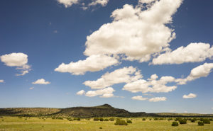
On the high plains of Western New Mexico, puffy clouds cast a shadow on one of the cinder hills.
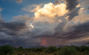
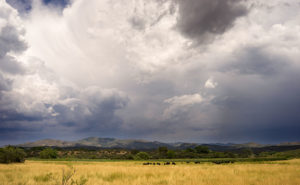
This Saturday, ten miles up the highway, the town of Yarnell will be having a block party that they call Yarnell Daze Mountaintop Festival. The celebration on the hilltop is bigger than ours because they have a chamber of commerce. There is a parade, live music, and different activities scheduled all day, but the one thing that warrants me writing about the festival is the art show. The organizers have invited artists from Wilhoit to Wickenburg to show samples of their work and I have submitted these three pictures from my cloud series for the show.
As the sun began to drop below the horizon, this beautiful thunderhead moved southward over the Weaver Range.
The festival starts off with a pancake breakfast at 7:00 am, hosted by the Yarnell Fire Department. The parade begins at 10:00 am (remind me to tell you the story about the parade in Kanab sometime). The art show is inside the Big Blue Barn on AZ-89—it’s the only two-story blue building in town and it’s on the east side of the street. If you go, there are also a couple of good cafes to eat at if you don’t want pancakes and besides the art show, there are a myriad of antique stores to peruse.
Monsoon clouds move down from the Bradshaw Range in Skull Valley.
Unfortunately, Queen Anne extends her regrets. It seems that her posse is gathering at Yaz’s house for The Wedding. If you can believe this, they will be getting up at 2:00 am to watch TV while wearing tiaras and consuming high tea. Right now she’s busy in the kitchen making cucumber and egg salad sandwiches. She’s already cursing about the nail she broke while trimming the bread crust. Knowing that group, I bet they oversleep and miss it.
Ask any Arizonan about Yarnell and they’ll most likely tell you about the horrible 2013 fire that swept through the town and the 19 hotshot firefighters that lost their lives when the fire trapped them, in an open field. It’s a big deal for us and to honor those men, Arizona built the Granite Mountain Hotshots Memorial Park. Someday I hope to show that park to you, but I must first build up my stamina to be able to complete the seven-mile round trip trail over a 1200’ elevation rise. For now, I want to talk about another Yarnell attraction that’s celebrating its 79th anniversary this year; The Shrine of Saint Joseph of the Mountains. I’m guessing it’s a place that even most Arizonans haven’t heard about.
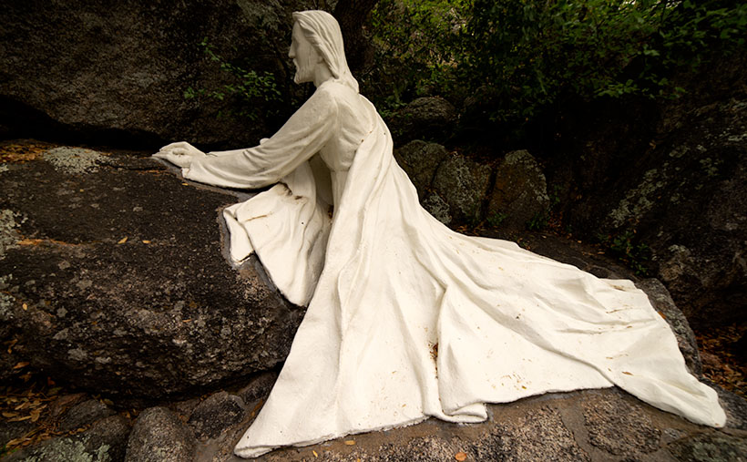
As you travel north on Yarnell’s main street lined with antique shops, it’s very easy to miss Shrine Drive, a paved road on the east side barely wide enough for passing cars. The road winds through dappled shade of scrub oaks lining Harper Canyon. The pavement only lasts a half mile, and when it turns to dirt, it’s at the Shrine parking area. As you get out of the car, the first thing you notice is how quiet it is. Even the birds whisper. You don’t see much at first, but through the trees in front of you, seated at a table is a welcoming statue of Jesus.
Praying Jesus – A statue depicting Jesus Praying is an example of Felix Lucero’s artwork at the shrine and makes a stop worthwhile.
The retreat (park, pilgrimage, or however you may interpret its purpose) was the concept of the Catholic Action League of Arizona in 1934. They worked on the plan for four years and contracted self-taught sculptor and unemployed dishwasher Felix Lucero who was living under the Congress Street Bridge in Tucson. Felix’s life is a story of its own and his other collection of work is in Tucson’s Garden of Gethsemane; now know as Felix Lucero Park. The shrine is a representation of the 14 Stations of the Cross—a ritual where Christians symbolically stop and pray at significant events that happened on Jesus’ crucifixion path. The stations at the shrine are along a stair pathway that climbs the mountainside culminating with a sculpture of Jesus on the Cross. Then you continue down the stairs past the last stations until you reach a sculpture representing the resurrection—a slab in an empty grotto draped with a shroud cloth.
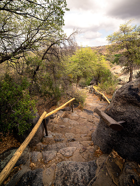
Stair Path – The stairs leading to the Stations of the Cross are often Steep. Considering that they already start at a moderate elevation, it’s not an easy journey.
The 2013 fire swept through the shrine site. It destroyed several of the support buildings, charred the trees, and completely burned some of the wooden station crosses. The fire burned away the crucifix on the hilltop completely leaving the sculpture of Jesus floating in the air suspended by bolts welded to a metal frame. Remarkably, the ivory colored statue was not damaged or discolored.
Shrine View – There are places along the path where the canopy opens revealing beautiful views of the surrounding countryside.
I went to Catholic school for four years and that was enough to cure me of organized religion, but as an artist, I enjoy the architecture of churches and the paintings, sculptures, and stained glass within them. I think that’s why I enjoy places like this shrine. I can see the thoughtful planning, hard work, and attention to detail found here. Besides, as you near the top, the tree canopy opens, and you have wonderful views of Yarnell and the Weaver, Bradshaw, and Granite mountains.
The next time you’re traveling the back road to Prescott, I recommend you spend some time visiting The Shrine of St. Joseph in Yarnell. If nothing else, walking the stations is good exercise. Let me warn you that your starting elevation is 4700’ and the stairs are steep. It’s almost a rock scramble; bring water. You’ll enjoy the art, the views, and the serenity. There’s no charge but there is a donation box that you’re welcome to use.
While testing new photo equipment last weekend, I stopped at a spot on the road that I’ve meant to stop at since we moved to Congress over two years ago. Before this weekend, I was either in a hurry, or there was too much traffic, and there was no room to get off the road. This spot is part of the famous Yarnell grade, a stretch of Arizona State Route 89 that winds through the scenic landscape. The Yarnell grade is known for its steep descent and tight curves, making it a challenging drive for many motorists. However, it also has a unique and intriguing landmark—the legendary Elephant Curve.
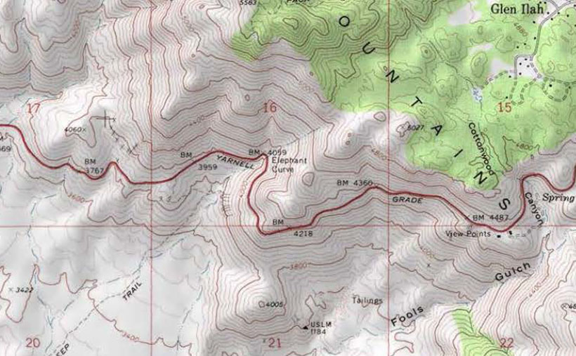
Elephant Curve – As shown on the USGS Topo map, Elephant Curve has earned its spot on the map, but what happened there?
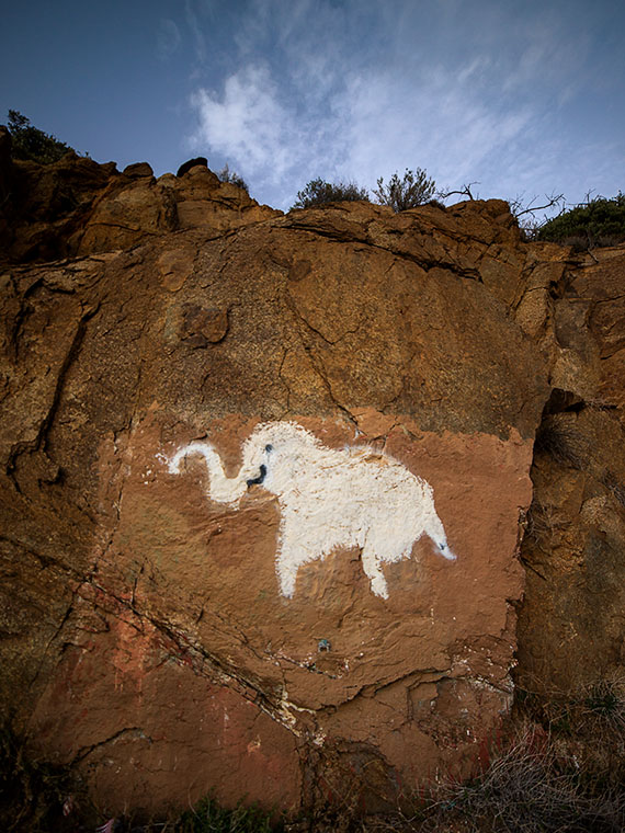
It’s a real place, and the USGS Topographic map shows its name, and at that curve, there is always an elephant painted on the rocks. Once or twice a year, the Arizona Department of Transportation, or a disgruntled Democrat, will cover over the pachyderm. Someone else takes it upon themselves to draw a new version within a week. This is the fourth iteration that I’ve witnessed since we moved here.
Elephant Rock – This is the latest version of our elephant-on-the-rock. The rock art gets painted over annually but quickly reappears within a week. The version before this was in pink paint and traces of the pink area on the pachyderm’s back.Why is this elephant so important? My favorite legend is about a circus caravan traveling to Phoenix in the late 1930s. As the group descended the newly paved but steep grade, one of the trucks lost its brakes and crashed into the rock, killing Scooby—their prized elephant—and as is the tradition in Arizona, the circus troop memorialized Scooby with a painting at the crash site.
Isn’t that sad? That would explain why the elephant painting should remain a lasting memorial marker. Unfortunately, when I researched the story online and visited the Congress Library, I discovered it’s all a myth. When I asked a long-time resident, she gave me a wry smile and muttered, “That’s just a made-up story. It never happened.”
A second local legend involves a miner returning home from a night on Prescott’s Whisky Row. Reportedly, he had to swerve at that spot to avoid a giant pink elephant in the road and crashed his car head-on into the boulder. This story explains why new versions are sometimes pink instead of white.
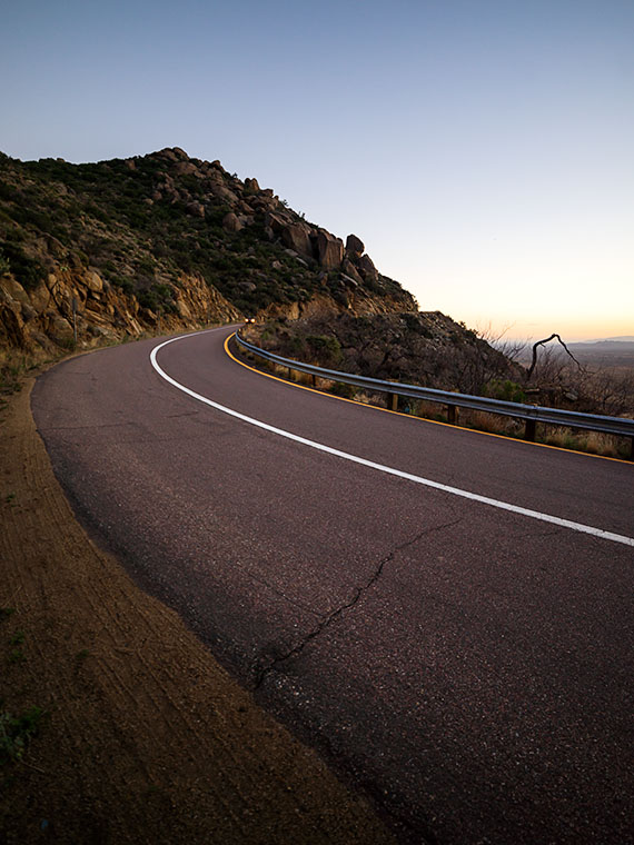
Elephant Curve – As you descend Yarnell Hill, Elephant Curve is the tightest and slowest you’ll meet. Five days after I took this shot, another accident ripped apart this section of the Armco barrier.
Neither story is true—so I’ve been told. The true story is that some unknown local with a strong sense of humor likes to perpetuate the elephant myths. I think there must be more than one artist because each version I’ve seen has distinctive brush strokes. Now that I’m in on the joke, I can picture myself out at night painting my take on Scooby.
For each picture of the week in this series, I normally select the best shots from the locations that I’ve written about. This week is a little different. I had to push back the scheduled image that I was going to use so I could insert a shot that I took yesterday. I intended to just shoot some test shots, but because this image fits into the current theme and because it came out better than expected, I decided to insert it into this week’s rotation. It’s called Yarnell Overlook named so because that’s where I shot it.
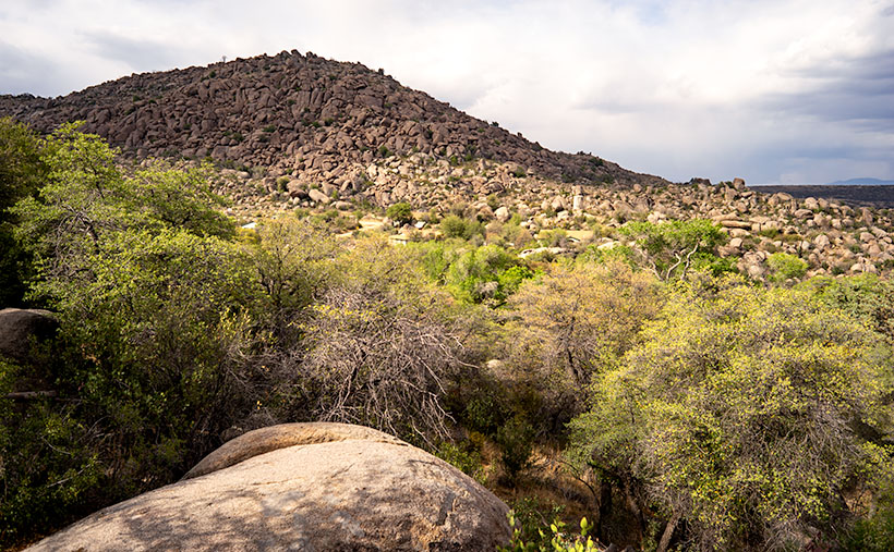
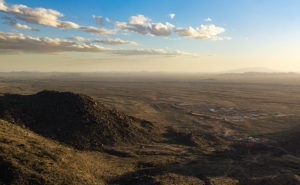
Yarnell Overlook – The vista from the Yarnell Overlook takes in Fools Gulch in the foreground to Harquahala Mountain—fifty miles to the west.
I ordered a tripod part from Amazon that arrived Friday and I was anxious to put it to work, so I decided that I would ‘run up the hill’ at sunset and test it at the overlook. It was an easy place to get to and there’s little traffic there. During the day, I was concerned because of a boring cloudless sky and the winds kicked up a layer of dust making the atmosphere hazy. I resigned myself that the results would technically be OK, so I didn’t expect more than that. As sunset approached, however, a few puffy clouds began forming near the Weavers which picked up my spirits. After dinner, I packed my gear into the car and set off for the pull-out located half-way up Yarnell Hill to conduct my test. The view from the overlook is most often hazy and the back-light from a setting sun is even worse for shooting a high detail photo.
After I processing the test, however, I think the results exceeded my expectations. Although the dust obscures the fine detail and acts, well … like fog adding some drama. I like it because of the afternoon clouds above the layer of dust. The viewpoint overlooks Fools Gulch with its working gold mine. The Stanton road that I wrote about for the last couple of weeks is just beyond the very large Parker Diary Farm that you can see in the middle-right. The last thing that is pleasing to my eye is the repeating round shapes of the boulder-covered foreground hill and Harquahala Mountain—some fifty miles away on the horizon. In case you’re curious, our house is located in a lighter patch of homes near photo’s center.
You can see a larger version of Yarnell Overlook on its Web page here. In last week’s post, I mentioned using a Like button. Fred correctly pointed out that when you follow the post links, there isn’t such a button. There are Like and Share buttons, but they are only on the blog’s homepage. To access that version, you need to first open my Webpage and click on the Blog link in the menu. That sounds like too much trouble, so I won’t bother mentioning them again. No matter which version you see, I hope you enjoy viewing my newest work.