Lava Tube and Brittlebush Picture of the Week

Everywhere I look, the desert is yellow, and it’s as thick as a jungle out there. When Queen Anne and I run into town, the train tracks—only a block from the road—are hidden behind the dense foliage. I supposed this was predictable with the good rains we had this winter. We had a good crop of poppies this month along with purple lupine and orange mallow lining the highways.

Several plants give to the yellow with the first to bloom is the Brittlebush. Their soft yellow flowers look like small pale yellow daisies on stems rising from sage-green leaves. Unlike the poppies, their color isn’t vibrant, but they’re so pervasive that they’ll turn mountainsides yellow. They thrive in disturbed soil, like the highway shoulders.

Creosote bush adds a second note of yellow. The lowly creosote is like the lawn of the desert, except it grows 4-6 feet high. A couple of weeks ago, the field across from the park was Kelly green. The bush’s flower is small—almost like buds, and now that they’ve popped, the green has a golden tint.

The yellow crescendo comes when the Palo Verde bloom. Last week, Her Majesty and I ran down to our dentist at the border, and along the way, the trees were already blooming in the low-lands. The bloom moves through the desert like an opening curtain into the highlands. Today I see the trees in our park are beginning to show the tiny flowers. At their peak, the Palo Verde dot the mountainsides with yellow splotches. It’s then you realize that they’re growing everywhere. There’s a color symphony, and quail provide the background music with calls as they stake out their territory. It’s the best time to live in the Sonoran Desert.
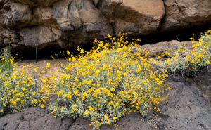
Lava Tube and Brittlebush
Lava Tube and Brittlebush – Three of the flowering plants grow among the rocks below a lava tube.

When Fred and I were out taking photos in Black Canyon a couple of weeks ago, I saw lots of brittlebush growing in the lava rock cracks. Their soft yellow popped against the dark, almost black canyon walls. Since they screamed, “Spring,” I wanted to capture the contrast. Out of the several shots that I took, I liked this week’s image best.

In the shot that I call Lava Tube and Brittlebush, three plants were growing below a gaping void in the rocks. I believe it’s a tunnel that formed when the molten magma lost pressure then receded. It’s just like when you were little, and your older brother tortured you by pinning you to the floor then drooled over your face but sucked the spit back at the last moment. The threat was always worse than the spit. Oh! By the way, on your first desert visit, inevitably someone will tell you, “Don’t sick your hand into any place you can’t see.” The lava tube is an excellent example of what they mean. I tried to get Fred to see if he could find any rattlers in there, but he refused. He was no fun at all.

Oh, if you’re wondering how brittlebush got the name, here’s an example of how they look after a couple of weeks without water.

You can see a larger version of Lava Tube and Brittle Bush on its Web Page by clicking here. I hope you enjoy viewing this week’s post and next week; we’ll show another featured image from a different Arizona site.

Until next time — jw

Black Canyon Rocks Picture of the Week

The Sonoran Desert is at its best in April, when spring drags everything back to life. The cactus bloom, mesquite trees put out new leaves, palo verde trees turn yellow, the animals are horny, and there are dead snakes all over the highway. Each year we don’t have to run the air conditioning or the heater for two months. We manage the house temperature by strategically opening or closing the windows during the day. But, along with the beauty and rebirth, we dread the coming heat with being stuck indoors and up to our eyeballs in power company debt. It’s like having sex and then a kid.

Arizona has always been hot—well, maybe except for the millions of years when it was a sea bed, but that was a fleeting moment. Not all the heat was from the weather. Our state is a hot spot for volcanic activity. We have over 600 sites of volcanic mountains, cinder cones, shield volcanoes, lava flows, and lava fields. Our two tallest mountains—Mt. Humphries in the San Francisco Peaks and Mt. Baldy in the White Mountains—are volcanoes that spewed ash, cinders, and pyroclastic flows at the same time (talk about dual exhaust). Not all the activity is ancient history. The most recent eruption was about a thousand years ago, and it’s not over yet. Geologists say there’s a 13% chance that another outbreak will happen in the next millennium.

As a photographer, all of these bumps, cracks, warts, and irregularities are what makes Arizona such a remarkable subject for pictures. I’m sure the millions of people who come and stand at the edge of our big ditch in the north would agree. So, what does all this have to do with my self-assigned Nothing project? I’m glad you asked.

As you travel north from the Nothing pass, Highway US 93 makes a downhill run to the bridges at Burro Creek, and on each side of the road is a small lava field that doesn’t have a name (according to my references). It must be ancient because it has enough vegetation that blends with the surrounding landscape. Along the flow’s southwest border, there is a spring and wash that carved a ravine through the lava bed called Black Canyon. It was this landmark that Fred and I set off to explore last week before getting distracted by George’s Camp—ooh, squirrel.

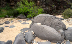
Black Canyon is easy to find from George’s because its mouth is next to the property—across the street if you will. Within a few steps, we began hiking up a wash that had cut through the dark basalt lava. As we continued, the walls grew higher, and big, water-polished basalt boulders littered the oatmeal colored sand. Their smooth surface contrasted with the rectangular blocks making up the canyon sides. Even though we walked in deep dry sand, it was clear that a lot of water must flow along the course. When wet, the dark gray boulders turn jet black which would be something to see, but since some of them were over my head, I’d prefer the higher ground.

Black Canyon Rocks
Black Canyon Rocks – Large pieces of lava that have fallen to the wash bed has been polished smooth by eons of water flow.

For this week’s featured image, I wanted to show the artistically placed smooth boulders contrasting the canyon walls. And I wanted to show the layers of textures: sand, worn stone, and rough wall. I also like the smaller white quartz placed within the basalt arrangements. Although I wasn’t paying attention to it, the mesquite’s bright new spring foliage adds dramatic color to the otherwise monochrome scene. I named this image Black Canyon Rocks.

You can see a larger version of Black Canyon Rocks on its Web Page by clicking here. I hope you enjoy viewing this week’s post and next week; we’ll show another featured image from Nothing.

Until next time — jw


Large Boulder Picture of the Week

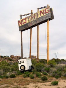
Nothing Arizona Sign
Nothing Arizona – Only a crooked sign and empty building shell are all that remains in Nothing

My generation is probably the last to have a love affair with automobiles. For us, cars defined who we were. They opened the country for us to explore. Now that we’re old, most of our recollections are car-centered, and I’m an example of that. Over my life, I’ve owned a varied stable of vehicles; from ones German engineered to station wagons that the Griswolds from Family Vacation would reject.

The car that still gives me the most angst was the Camaro that my parents gave as a wedding gift for my first marriage. It was special because it was the racecar version built for the original Trans-Am series. To qualify for the races, manufacturers had to produce at least 1,000 units, and they had to sell them through their dealer networks. Very few Americans knew they existed. I knew, because I read racing magazines, and after I got back from my overseas tour, I hunted one down. Their moniker came from the option package number—Z/28. After the first batch quickly sold out, Chevrolet offered them to the public.

It was British racing green with a pair of broad white stripes on the hood and trunk. Ours didn’t carry the familiar Z/28 badge on its nose; instead, it just had the numbers 302 which was its engine size. Trans-Am limited the displacement to 5 liters, and that meant that it was the smallest V8 that Chevrolet put into Camaros, but those engines were specially built and had more horsepower than the other power plants available. Since it was a high revving motor, you couldn’t get air conditioning or (gasp) power steering. Because I raced mine, I added 10” wide wheels and fat tires which made it near impossible for my wife to drive.

At the collector’s car auctions, 1968 Z/28s sometimes go for over a hundred grand, and because mine was a low chassis number, I believe it could’ve been more valuable if it were in pristine shape. But, I was living in a lot of turmoil and planned to move to Arizona where I would need an air-conditioned car, so I got a thousand dollars on trade for a Vega—possibly the worst purchase I ever made in my life.

It was mustard-yellow with a single black stripe. I wanted the GT version because it came with gauges instead of idiot lights. The dealer didn’t have one with air, so they installed an aftermarket unit, which was like bolting a cinder block to the side of the engine. Because of the weight and engine vibrations, the compressor fell off when the bolts sheered—twice. All of the gauges worked except for the water temperature, which I noted to the dealer while it was under warranty. They said they’d order one, but I don’t think that they ever did, and wound up rebuilding the engine after it seized from overheating.

My horrible decision meant that I gave away the impractical car that I loved, to buy the practical car that I hated, and that includes all the awful station wagons we’ve owned. Its gas mileage wasn’t any better than my hot rod, and with a nine-gallon tank, our gas stops doubled. The engine vibrations were so bad that I carried a screwdriver and wrench because, at each fill-up, I had to re-tighten the carburetor screws. The only fond memory I have of that car was besting the local legend—Don Roberts—at a Big Surf event. He drove a different Vega—a station wagon. That was a nice feather to have in my cap.

My second wife and I went to Las Vegas, Bullhead City, or one of those destinations involving Highway US 93. We packed the Vega—it never deserved a name—and headed north for the weekend. We planned gas stops in Wickenburg, Kingman, and Vegas—or wherever. However, because of the Vega’s limited range, we had to stop again after climbing the grade after the Santa Maria River—at Nothing, Arizona. I had to pay a buck-and-a-half for gas, which was highway robbery at the time. That makes me the only person in the world to have bought gas in this month’s featured destination—Nothing—population: 4.

The abandoned store in Nothing is at the top of the pass between the Poachie and Aquarius Mountain Ranges. Its elevation is 3700-feet, and the terrain is part of the granite boulder field that stretches from Prescott to Kingman. The store, as they tell it was, ”built by four drinking friends having nothing better to do.” It was open only a couple of years before being abandoned. I don’t remember this, but according to Wikipedia, in 2016, Century 21 ran a promotion for father’s day with the promotion line, “Give Dad Nothing for Father’s Day.” They sold 24-hour deeds to property in Nothing. The current property owner was in on the joke and buyers could download a gift card and a “Certificate of Nothing” valid on June 19, 2016, only.

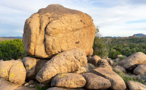
Large Boulder
Large Boulder – The landscape in the Nothing Pass is a boulder field like this delivery-van sized example.

So for April, I will be trying to make something from Nothing—pun intended—like this week’s featured image—Large Boulder. There’s some pretty country in the pass between the Santa Maria River and Burro Creek. My job is to find enough to produce four images for April. Do you think I’m up to it?

You can see a larger version of Large Boulder on its Web Page by clicking here. I hope you enjoy viewing this week’s post and next week; we’ll show another featured image from Nothing.

Until next time — jw

P.S. You should see my grammar checker going nuts over Nothing.

P.P.S. Speaking of old Chevys—this week I sat through a show that Queen Anne likes. I think its called The Kids Are Alright. It’s about a Catholic family with a gaggle of boys. They’re struggling to make ends meet, so they drive an old station wagon—a ’66 Chevelle. As I watched, I had to pause the show and show Her Majesty the station wagon’s nose badge. It indicated that the car had a 396 motor, but it wasn’t an SS model. Very rare and valuable.

89 Sunrise Picture of the Week

There are two types of drivers on the road. The first type is people trying to get somewhere, while the second group is people who are out for a ride. You’re not always stuck in one group or another. Sometimes you have an appointment to make; while on other occasions, you have all the time in the world. My dad was part of the gotta-get-there group. Once he got in the car, he didn’t stop for anything unless it was gas. Although he was our family’s driver, I don’t think he liked it much.

I’m part of the second group. On a day like today, sunny and temperatures in the mid-seventies, I relish driving an excellent machine down back roads with the windows down so the wind can blow where my hair used to be. These are the times when I feel most alive and free. Nothing beats driving an empty winding road with a hot blond beside you in the passenger seat—even if it’s just my blow-up doll—er, sorry. I got carried away there. I see a time soon when we’ll have autonomous vehicles, and that’s fine as long as I’m not in one.

That brings me to one of our community’s best features—the road leaving town. Up until the Second World War, our trail carried most of the traffic between Phoenix, Prescott, and Flagstaff. At that time it was part of the U.S. highway system, and its designation was US89. After the Highway Department opened the last section of Interstate 17, the Feds depreciated our road, and now it’s officially Arizona State Route 89. During its heyday, US89 stretched between the Mexican Border at Nogales and Canada at Glacier National Park, but today it stops at the US66 junction in Flagstaff.

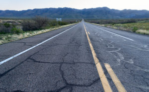
89 Sunrise
89 Sunrise – The road heading north out-of-town starts by climbing over the Weaver Range at Yarnell Hill.

Now that most of the traffic is on the freeway, SR89 has become a scenic back road that drivers love with low traffic, almost no trucks, plenty of curves, and a variety of scenery. I can prove it. On any weekend you can sit in your lawn chair at our park’s driveway and watch clusters of geezers on Harleys, boy-racers on rice rockets, and waves of sports car clubs headed north on Saturdays and south on Sundays. On weekdays, the proving ground boys’ wiz by driving disguised test cars and trucks. You know they’re having fun because you can see dilated eyes behind their Ray Bans and they have big grins on their faces.

When I thought about this week’s featured image, I wanted the road front and center, and the spot that I chose is where SR89 heads towards the Weavers as if they’re going to crash. They don’t however, because, at the last moment, the road turns right and starts up Yarnell Hill. If you’re traveling in a group, that’s where the race starts—well, actually I don’t need others because I raced in autocrosses—ask Queen Anne.

For this shot that I named 89 Sunrise, I wanted to have my tripod in the middle of the street, so I needed an empty road. That’s why I got there and set up before this morning’s sunrise. The highway is the subject of my image, but the Weaver’s aren’t bad either. In this shot, there’s a lot of green, but in a few weeks, it will turn golden brown.

You can see a larger version of 89 Sunrise on its Web Page by clicking here. I hope you enjoy viewing this week’s post and come back next week when we’ll start a month of featured images from another Arizona place.

Until next time — jw

North Bound
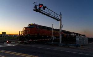
North Bound – An early morning freight train at the Congress Crossing.

PS—As I was finishing up this morning’s shot, I could hear a freight train pulling the Wickenburg grade, some four miles away. So I quickly packed up and rushed down to the crossing and got this image. It’s not the shot that I described last week, but at least it’s a train.

Sunrise on Track Picture of the Week

There are only a half-dozen places Queen Anne, and I frequent in our home town of Congress. There’s Nichol’s West—our favorite local restaurant, the Post Office, the clinic, the Kwikie Mart, and the Dollar Store. Oh, I forgot the dump. For anything else, we have to drive into town or—shudder—the big city. Half of those in-town destinations are on the west side of the railroad crossing, which never has a train—most of the time.

I wrote in a newsletter about our train when we first moved here. This section of track is called the Pea Vine Grade that follows Highway 60 out of Sun City till Wickenburg then continues north to Prescott and Ash Fork. The name is descriptive of the twists along the route.

The tracks aren’t busy like the southern route in Yuma, or the north through Flagstaff. This route isn’t bustling and only has four to six passing trains each day. They’re not on any schedule that I can discern and you don’t hear them go by as much as you feel their bass vibrations, especially the ones coming up the grade. The five engines work hard dragging loaded freight cars up the hill, while the ones headed south sound like a wooden roll-a-coaster as they effortlessly roll downhill. Their horns only blare in Wickenburg and the Congress crossings. That’s too far away to hear from the house unless we’re sitting on the back porch and there’s a north breeze coming off the mountains, but even that’s so faint that it’s like a scene from a Steinbeck novel.

Sunrise on Track
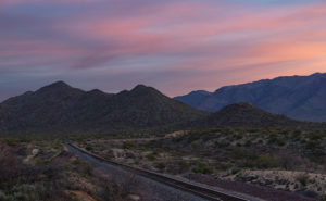
Sunrise on Track – Dawn breaks with a red sky over the railroad tracks heading north from Congress Junction.

This week’s featured image turned out completely different from how I originally visualized it. I wanted to capture this shot with a train in it. The tracks come into Congress Junction from Hillside through the valley between the Date Creek Range and the Weaver Mountains. On most mornings, there’s an early southbound train. We’ve seen it while we’re out for our morning walks. To further set the scene, the Date Creek Range foothills at the crossing are prettiest at sunrise. The rest of the day, they’re flat and dull. So that’s what I had in my mind when I drove there in the dark.

I previously scouted out a lovely spot overlooking the tracks, and I set up my camera and waited for the characters to arrive. As the eastern sky got brighter, the clouds overhead turned red, and I thought, “Ooo shiny.” I fired off a couple of frames. As I waited, the fast-moving clouds moved east and began to block the sunrise removing any drama from my scene. Besides, no trains showed up. Disappointed, I packed up and drove around town looking for other subjects to shoot.

When I got home and reviewed my images, this was the shot that impressed me the most. Even without a train, the tracks are a leading line that moves your eye to the foothills.  The light bouncing from the clouds tints the scene pink, and that light softly brings out the mountain’s cone shape. There is a feeling of tranquility in this shot. It’s a moment of quiet and calm.

You can see a larger version of Sunrise on Track on its Web Page by clicking here. I hope you enjoy viewing this week’s post and next week; we’ll show another featured image from Congress.

Until next time — jw

Rock Frog Picture of the Week

Our adopted town of Congress is a small retirement community, although it wasn’t always that way. Like most of the old mine towns around here, plenty of people lived here as long as they could yank gold out of the dirt; at times, there were even more people here than living in the little farming village called Phoenix. After all the money was gone, there wasn’t any reason to hang around here. The soil’s too rocky to farm, and there’s little to see here.

However, We have one attraction that puts us on the map, and I like to think it came from boredom. I imagined one summer’s day in 1928, and young Sarah Perkins–a homesteader’s wife—was in the shade of their front porch seeking relief from the oppressive heat. As she rocked in her chair, sweat soaked her gingham dress. The glass of refreshing lemonade that she held to her brow felt good as she stared at the pile of rocks across the highway near the railroad tracks. She turned to her husband sitting in the chair beside her and said, “Lester,” (I couldn’t find his name, so I picked one from my head) “The next time you’re in town, I want you to pick me up some green paint.”

Lester was a wise man who knew better than to ask, “What for?” A couple of weeks later, when he returned from town in the Model A pickup, two cans of Sarah’s paint and three large brushes were buried within the other provisions. The very next day, in the cool of the morning, she led her sons across the road to the pile of rocks, and they began to paint.

Frog Rock
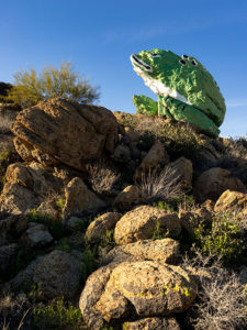
Frog Rock – The pile of boulders painted to look like a frog has been a Congress landmark since 1928.

If that’s not how it happened, it’s how it should have been when Sarah created our green rock frog. I agree, it’s tacky kitsch, but it’s our giant ball of twine, our world’s largest ketchup bottle, or our Lucy the Elephant. It’s a point of pride in our town, and when the paint fades, a self-appointed committee repaints it. I think that the Highway Department has given up on removing it, because, like the elephant on Yarnell Hill, it always returns. This last time, they added spots to the frog’s back.

I wanted to show more than just a frog when I shot the frog. I wanted to show how the 50-ton boulder looked unpainted, so I included some granite boulders in the foreground in a supporting role. I call this week’s image Rock Frog partly because I had a B-52 song stuck in my ear.

You can see a larger version of Rock Frog on its Web Page by clicking here. I hope you enjoy viewing this week’s post and come back next week when we’ll show another featured image from Congress.

Until next time — jw

Mobil Antlers Picture of the Week

A long time before we moved here, I remember driving through our little hamlet and noticing the old buildings in town. Queen Anne and I were traveling to visit my folks in Kingman, and after leaving Wickenburg, traffic stopped. Thinking it must be a result of an accident, I said to Anne, “We can detour around it by going to Congress.” It was ten miles out-of-the-way, but at least we’d be moving. It was when we reached the village that I saw the structures and said to her, “That’s so cool. I don’t remember this being a ghost town. I’ll have to come back and photograph it, someday.” (As an aside, my detour didn’t work because the accident was further north on US 93. We finally drove over to the river and took US 95, which put us several hours behind.)

There’s a reason why I didn’t remember those old buildings even though I had gone that way several times before. They weren’t there. After moving to Congress, that someday that I had set aside to photograph Congress’s historic district finally came. When I did, it disappointed me to learn that they’re a fake, like a back-lot movie set. The buildings are empty shells apparently used to display someone’s antique sign collection, but I don’t know why. It’s like someone threw up some structures as a tourist attraction and then quit before finishing.

The area of town at the  AZ 89 and AZ 71 junction isn’t the historic part of Congress. It used to be called Congress Junction or Congress Depot. The historical part of town was up Ghost Town Road near the mine. In this Wikipedia article, there’s a 1914 photograph that shows how it was. When the mine closed in the 1930s, the town moved to today’s location—lock, stock, and barrel. All of the buildings in the photo are gone. The land was scraped clean, including the mine structures. The only thing remaining is the old cemetery and a shed for Stephan—the mine’s caretaker.

Wouldn’t it be nice if someone bought and moved these buildings along the railroad tracks from old town? I don’t know, because there’s nothing to explain their existence. The only remaining business there is someone selling landscape rocks. Maybe you know the story and can share it with us, or perhaps, when I get a ’round-to-it,’ I’ll investigate and post an update.

Mobil Antlers
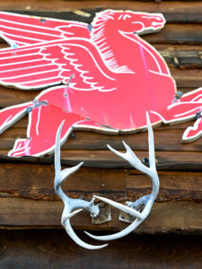
Mobil Antlers – An antique Mobil Oil flying horse is displayed over a pair of antlers at Congress’s fake garage.

I’ve pretty much ignored this part of town for the past three years, but since we’re featuring Congress during March, I wanted to show you what always catches my eye as I drive by them. It’s the Mobil Oil red flying horse sign. I’d like to have something like it to hang on the gable over my garage door—perhaps a Ferrari, Porsche, or one from Sunoco. To be accurate, however, my sign would be for beat-up Chevy station wagons.

In this week’s featured picture that I call Mobil Antlers, a set of antlers upstage the flying horse, so I concocted a fantastic story about it. It represents a tale about a red horse that soars high in the sky. He spots his prey in the meadow below—a handsome buck. The horse swoops in for the kill, and there’s a mighty struggle with the deer attempting to gore the soft underbelly of its attacker. Red-horse prevails and devours Bambi except for the antlers because they’re indigestible. Then I thought, nah—I’m not going to say that—it’s just too bizarre, and people will think I’m weird.

You can see a larger version of Mobil Antlers on its Web Page by clicking here. I hope you enjoy viewing this week’s image and come back next week when we’ll talk more about Congress.

Until next time — jw