Perry Mesa Needle Picture of the Week

Perry Mesa Needle
Perry Mesa Needle – This needle is at the edge of Perry Mesa above Black Canyon City. It’s new to me because it’s hidden from the freeway.

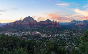
Phoenix only has two interstates that will get you the hell out of Dodge; Interstate 10 which either takes you west to California or east to everywhere else, and Interstate 17 going north. Driving I-10 in either direction always seems like a dreary, endless drive through the desert, while I associate I-17 with good times, like playing in the snow or—during summer—just escaping the heat. I think it’s because of all the different climate zones it goes through, like the desert, grasslands, riparian, and alpine forests.

The first change that you come to when heading north is the grade at Black Canyon City. It’s an abrupt transition from the Sonoran Desert to riparian grassland—saguaros are at the bottom, and they’re not at the top. It freezes more often at higher elevations, and the giant cacti can’t tolerate it. Black Canyon City is distinguished by being the northern edge of the Sonoran Desert; I know that because it says so on their welcome sign.

Most Phoenicians consider Black Canyon City a suburb populated with free-spirited residents. It’s the bottleneck on the highway where heavily ladened trucks insist on passing one another up the steep grade, or traffic is backed up to Prescott because a crash closed the freeway and there’s no other way around. During heavy rain, the community makes the news because the Agua Fria River floods and people get trapped in their homes or cars. If you do stop in town, it’s to get a slice of pie at its famous restaurant. I wouldn’t be surprised if most Phoenicians didn’t know Black Canyon was in a different county—Yavapai. I know that I didn’t, and that’s why I chose Black Canyon City as my place to look for October’s art.

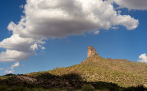
I saw the subject of this week’s photo as I was driving around town. I-17 divides Black Canyon City in two. The business district is on the freeway’s west side while on the east is mostly residential and a few light industries. The needle can be seen on the east side but not from the interstate. That’s why I didn’t know it was there. It’s like a smaller version of Weaver’s Needle in the Superstitions, but as much as I searched, I couldn’t find its name. There was nothing on my topographic maps, highway maps, the Gazetteer or the city’s website. I saw this neat YouTube drone video, but it doesn’t list a name either. It’s on the southwest corner of Perry Mesa (sounds like an excellent name for a lawyer, doesn’t it?) where Squaw Creek runs into the Agua Fria River, so I used that moniker for the photo’s name—Perry Mesa Needle.

In this image, I like the way the low clouds and their shadow frame the subject. The grove of saguaro midway up adds scale to the outcrop. Finally, the recent rains cleared the air and gave me a deep blue sky making the puffy white clouds seem to pop in 3D. As was the case with the Jerome Hollyhocks a couple of months ago, if you know this needle’s name, please email me.

You can see a larger version of Perry Mesa Needle on its Web Page by clicking here. I hope you enjoy viewing this week’s post and come back next week when we’ll feature more from Black Canyon City.

Until next time — jw

Capitol Butte Picture of the Week

Sedona is the most romantic town in Arizona. Don’t believe me? Just watch the Social Sound Off question on the evening news. Each evening, they ask a trivia question about Arizona. The news people get lists from internet sites or magazines about the most popular places for something or another. If the question is about tourism or travel, the answer is either the Grand Canyon or Sedona. The romance question was a recent topic and—you guessed it—Sedona was the answer. For more evidence linking the Red Rock Country to lovers, try booking a hotel room in Sedona for Valentine’s Day. The closest room you’re likely to find is in Eloy.

Capitol Butte
Capitol Butte – a tribe of millionaire-Bedouins have camped in their shabby-chic tents for the night among the red rocks of Sedona.

It’s been over a decade since I last visited Sedona and all of the changes shocked me. Gone is the quiet dusty little creek-side town nestled in Oak Creek Canyon. Back then, there were the usual galleries, jewelry, and souvenir stores in the village, but now it looks like Scottsdale or Newport Beach. The single traffic light has been replaced with dozens of traffic circles. With its limited space and water supply, Sedona has always been the place we loved to death and surely it’s now ready for hospice care.

As a photographer, I’ve been frustrated when shooting there. When you’re trying to get a shot that tells the town’s story, you’re thinking about red rocks, Oak Creek, and the old sycamore trees. You can get that shot at Red Rock Crossing State Park and virtually every photographer has it in his or her portfolio. On this visit, I wanted something different to photograph, so I did a bit of exploring. I hiked a short trail in Boynton Canyon and I ended my day on top of Airport Mesa.

I hung around after sunset until the crowd left—there’s a dedicated parking lot for this viewpoint and people pay three-bucks a car, who knew? I wanted the town dark but have Capitol Butte lit with the soft residual light in the western sky, so I waited until the town lights began to come on.

I believe that I got a different interpretation of this familiar view. I called this image Capitol Butte after the red-rock feature towering over the village. It shows how packed the dwellings are between the rock formations that draw so many people from around the world. I like the contrast of the orderly north-south-east-west streets within a so-called nature setting. When I look at this image, I see a tribe of millionaire-Bedouins camped for the night around the waterhole.

You can see a larger version of Capitol Butte on its Web Page by clicking here. I hope you enjoy viewing this week’s post and come back next week when we’ll show more from Sedona.

Until next time — jw

Lime Lichen Picture of the Week

Lime Lichen
Lime Lichen – The main lichen growing in the Granite Dells is either orange or a pale green. Every so often, you’ll find a bright green patch such as this.

In last week’s post, I wrote how the Granite Dells boulders weren’t just bare rock, but they’re covered with living organisms which gives them color and texture. As you hike along the trails and take a closer look, you’ll find lichen, moss, fungi, and things that only a botanist could name growing there. Although they resemble a plant, lichen is a relitive of algae. They don’t put down roots, but instead, they get water and nutrients from the air. Lichen has a surprisingly long lifespan, but they don’t handle pollution well. When we were landscaping our Goodyear home, Anne and I specifically picked out some boulders that had a green specimen growing on them. Within six months, all the growth vanished.

There are two predominate colors of lichen in the Dells, an orange and another that is light green—seafoam if you will. Occasionally there’s a patch of a bright green specimen that catches the eye, and that’s how I happened upon this shot. The green was a small part on the larger rock surface, so to make it stand out, I moved in close enough and made it the subject of this photo. I like the way the bright green dominates the other muted colors. In all, I count four species growing in this shot. Because there’s not a structure in it, the abstract image is about color and texture. I call it Lime Lichen.

You can see a larger version of Lime Lichen on its Web Page by clicking here. I hope you enjoy viewing this week’s post and come back next week and see more from the Granite Dells.

Until next time — jw

Orange Boulders Picture of the Week

Orange Boulders
Orange Boulders – Lichen-covered granite boulders have weathered and fell off their tight-fitting stack.

A this week’s featured image shows, the trails of Granite Dells City Park provide diversity you wouldn’t expect to find in a massive formation of slow-cooled lava. This week’s featured image shows a small example of that. It comes from one of the Flume Trail’s spurs. Instead of walking around a ridge, this option climbed over it, before it descends and rejoins the main path on the other side. I’d call it a shortcut, but since it added a climb, it didn’t save any time.

On the ridge, the view opens, and since the granite pile tops were exposed to weathering longer than below, so more of the car-sized boulders lay scattered on the ground. If you’ve only driven by The Dells, you’d get the idea that the rocks are nothing but dirt. As you can see in this image, they’re actually covered with lichen of various colors. Here an orange species grows next to a green varietal. Up close, they give the rocks a velvety texture.

I stopped along the trail to capture this image because this tumbled pile of rocks stood apart from assembled puzzle stacks surrounding them. The distinct orange color caught my attention too. There are other colors that you’ll see as you walk along the trails. We’ll bee seeing some of those in other photos this month. Finally, I included a bit of the trail in this image to add a leading line and some perspective to the image.

You can see a larger version of Orange Boulders on its Web Page by clicking here. I hope you enjoy viewing my newest entry and come back next week when we show another photo from Granite Dells.

Until next time — jw

Dells Scrub Oak Picture of the Week

Dells Scrub Oak
Dells Scrub Oak – The green of a mature scrub oak stands out against the Granite Dells boulders.

This week’s featured image is one that I took while exploring the Flume trail that parallels Granite Creek below the Watson Lake dam. State Route  89 divides Granite Dells Park as it heads north out-of-town, with the Willow Lake complex on the west side and the Watson Lake facilities on the east. Each division has trails that meander through the maze of boulders. The main series of trails around Willow Lake is called the Constellation Trails. I’ve only had a taste of that trail system, but I want to hike there some more. I have hiked a couple of the trails around Watson Lake and I’ve completed the Flume Trail twice.

The trailhead is located along the north park boundary. Access to the parking area is via East Granite Dells Road. The trail is almost a mile long in each direction and has a couple of moderate climbs over a couple of ridges, but a lot of it is flat. At its start, it runs between private properties so you’ll see signs warning you to stay on the path. After the first hill, the trail drops into a wide grassy area where you walk creekside under a growth of Cottonwoods. There is a second ridge you must traverse before the trail returns to Granite Creek and stays there up to the dam. When water is high, excess water rushes out of a flume—sort of an artificial waterfall. The water has been low for several years, so the flume is rarely used.

We visited the Dells on our June Costco run, but I wasn’t ready and made a stupid mistake. We left home early so I could go shooting before the warehouse opened. I wanted to photograph with a low sun for the color and it was around half past eight when we got to the parking area, but the day was going to be hot—even in Prescott. While Anne waited in the shade, I grabbed my camera and a second lens and then headed up the trail without water. It was going to be a hit-and-run shoot lasting an hour, tops. I hiked this trail five years ago without problem when we spent the 4th in Prescott. This time I underestimated the strenuousness of the climb, the morning’s heat, and the extra two-thousand feet of altitude. By the time I stumbled back to the car, I was in such bad shape that I made Anne drive us to breakfast while I downed a quart of water. When we got to Costco, we bought a small backpack that I can carry camera equipment and a couple of bottles of water in. Live and learn, eh?

I came upon this scene at the trail’s beginning. After leaving the parking area and making my way over the first hill, I saw this scrub oak—a rather large and nicely shaped one at that—growing in the rock cracks. The green of its leaves stood out against the tan of the granite boulders towering over it. The wispy clouds made the blue sky interesting, so I included them in my composition.

You can see a larger version of Dells Scrub Oak on its Web Page by clicking here. I hope you enjoy viewing my newest entry and come back next week when we present another photo of the Granite Dells.

Until next time — jw

Granite Dells Sunset Picture of the Week

Granite Dells Sunset
Granite Dells Sunset – Prescott’s city park has two creeks, two lakes, and a bunch of rocks to climb. It’s a playground for adults and a wilderness experience inside city limits.

Welcome to July—the start of the year’s second half and when our nation comes together to celebrate Queen Anne’s birthday. Time flies when you’re having fun … and evidently, even when you’re not. As we tear another month from this year’s calendar, it’s also time to introduce the place we’ll visit: Prescott’s Granite Dells City Park. We were here five years ago during the tragic Yarnell fire, but this time, we came better prepared with experience and a real camera.

Granite Dells—or The Dells—is a “McDonalds’ playground” for adults. The park’s trails take you through or around the rock maze. There are secret rooms to discover, rocks to climb, narrow passageways to squeeze through, and creeks to ford. The only thing missing is the restaurant’s ball pit, where kids pee. The trail lengths vary so that you can spend an hour or an afternoon wandering among the giant boulders all day.

A million and a half years ago, a magma pluton—a six square-mile glob of molten lava shaped like a giant balloon—tried to force its way to the surface as the eruptions in Hawaii have done. Instead, because it didn’t have enough energy to bust through the rocks above, it was trapped and cooled slowly and crystallized into granite. Another famous example of a pluton is Yosemite’s Half Dome. As millennia passed and the forces of erosion and plate tectonics shaped the earth, the pluton eventually made its way to the surface. It has been exposed there long enough for the formation to fracture and undergo spheroidal weathering—the erosion that rounds the rock’s edges. Yavapai County has two other places where you can see these kinds of rock formations: the town of Yarnell along SR 89 and the hilltop where the truck stop of Nothing once was on Route US 93.

The two creeks that drain through the Dells, Granite and Willow, were dammed in the early 1900s as irrigation reservoirs by Chino Valley farm co-operatives. In 1998, Prescott acquired a chunk of Granite Dells, including the lakes, and has set aside the area as an open-space park. The usual picnic areas and sports fields are there, but the backcountry trails lead into parts of the park where you get a taste of wilderness experience. That illusion is occasionally broken when the trail passes a No Trespassing sign along the periphery.

When we visited the park in June, we saw new home developments on its northern flank and another proposed on the east side along the Peavine Trail near Point of Rocks. The development was met with community outcry and packed meetings at city hall. Concerned citizens worry that the new developments will irreparably change Dell’s character by blocking wildlife movements and introducing a sea of roofs to the landscape. It’s another example of a good thing being loved to death. I guess it’s true what they say, “You can’t have your Kate and Edith, too.”

I took this week’s image after a Prescott meeting—not at city hall—that I attended. The sun was about to set, so I rushed to the Dells to get this shot. When I got to the Watson Lake overlook, I knew I wanted to capture this sweeping scene with the most detail. The format is a little different for me because this is a four-shot panorama. I took four shots and stitched them together in PhotoShop. The resulting file size is four times larger than my usual shots, and I can make a print thirty-six inches wide at full resolution. I made a crop of the shoreline tree in actual size to show how much detail I got using this method. This image is called Granite Dells Sunset.

Tree Detail
A full-size crop of the shoreline tree in this week’s image shows how much detail is in this image.

Click here to see a larger version of Granite Dell’s Sunset on its Web Page. It’s easier to find the tree in the larger version. I hope you enjoy viewing my newest entry and return next week when I post shots I took while hiking the park’s trails.

Until next time — jw

Bobby D’s BBQ at the English Kitchen Jerome Restaurant Review

English Kitchen
English Kitchen – Originally built using adobe blocks by Charley Hong to replace his Connor Hotel kitchen that went up in flames in 1899, was open until 2007. Until then, it was the longest-running restaurant in Arizona. Despite its name, they served Chinese food when Charley ran the place.

To coerce Queen Anne to join me on a photo outing, I have to bribe her with something precious—like food or ice cream. If I schedule everything carefully, I can get away with having to pay for only one meal while we’re on the road. I wanted to shoot in Jerome in the good afternoon light and the drive from our house is a little over a couple of hours, so my cheapest bet was to buy her lunch. When we travel we use the TripAdvisor rankings to see what the popular restaurants are at our destination. It eliminates some guesswork picking out a place to eat. We look at the best reviews and then try to find them when we get to town and for our Jerome trip, Bobby D’s BBQ was their top pick.

Bobby’s is in the English Kitchen Building directly across the street from the Liberty Theater. The old building has hosted various restaurants since Charley Hong built it in 1899, according to the story on the back of the menu. I enjoyed reading the part about the English Kitchen name because—being a Chinese restaurant—it never served traditional British fare. If unwitting diners ordered an English breakfast, they were more likely served a dish of chop suey.

The interior of the original building is simple with about dozen wooden tables and historic Jerome photos decorating the wall. There’s not much room inside and since it was a pleasant day, we opted for seats on the deck. Our friendly hostess quickly found a spot at one of the many picnic tables. We enjoyed a nice breeze in the shade of the orange canopies and gawked at the Verde Valley panorama while the aroma of the smokers seduced our appetites. Our pleasant waitress brought menus and took our drink orders before we finished looking around.

Bobby D’s is a BBQ joint and the staff proudly proclaims that they’ve won a Best in Arizona award. The first page of the menu is all BBQ, but we weren’t that hungry so instead, we split the Arizona Cheesesteak from the second page. It consisted of brisket, sautéed onions, pepper jack cheese and (Ortega) chilies stuffed into a hoagie. It sounded different. It came to the table dry along with four house-made sauces for us to sample.

I’m a guy that likes BBQ and I’ve cooked a mean rib a time or two. I like a lot of flavor. A good sauce should singe your nose hairs but leave a sweet taste. The sandwich was good, but it surprised me at how little smoke and rub seasoning was in the meat. While I’m picking nits here, the mild chilies they use are lost in such a bold sandwich as this—jalapeños would have been a better choice. Their BBQ is southern style so one of the sauces is mustard-based, but it was too reminiscent of honey-mustard dressing for me. A second blend they have is called Jalapeño Molasses and again the chilies were missing in the sweet syrup. That leaves their Little Miss Tango sauce as my pick among the three. Anne liked it too—so that alone shows that it wasn’t spicy enough.

Bobby D’s is a good place in Jerome for lunch or an early dinner. It’s fun to eat in and learn about the historic diner. Our service was very good, and the staff was attentive. The food was also very good even if I felt it was on the bland side. Is this the best restaurant in Jerome? The reviews say it is, but I haven’t tried the others. Is it the best BBQ in Arizona? I’ve had better, but BBQ is always a safe bet. Because Jerome isn’t an overnight destination, many of its restaurants close by 2:00 while Bobby’s is open until 6:00. If this were a Yelp or TripAdvisor review, I’d offer four out of five stars.

Until next time — jw