Casa Malpais

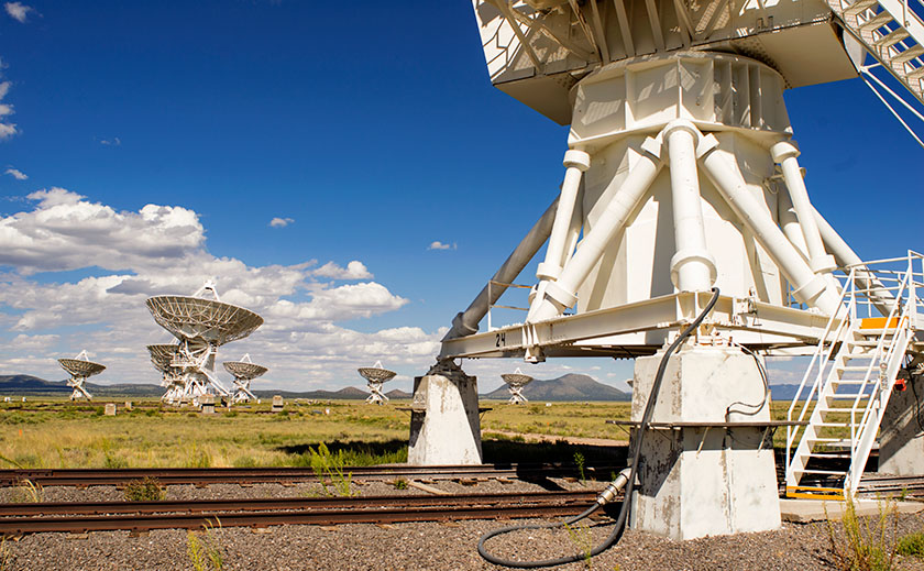
One of the things tourists do upon arrival is to visit the city park. I don’t know why, but when you browse the brochures, the local park is usually at the top of the list of to-do things. For example, San Francisco has the Golden Gate Park, there’s Central Park in New York, and Griffith Park in Los Angeles. Phoenix has the Margaret T. Hance Deck Park, but I don’t think anyone has ever gone there. These are open spaces within the city that their leaders felt important to protect from development. Springerville has Casa Malpais which isn’t really a park in the traditional sense of the word, but rather a fourteen acre archaeological preserve that the city owns and maintains. In other words, it’s a Pueblo Indian ruins.

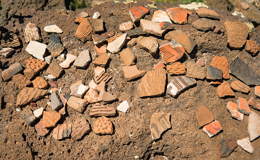
Listed on the National Register of Historic Places since 1966, Casa Malpais was built on a basalt ledge overlooking the Little Colorado River a couple of miles north of Springerville. The Mogollon people lived there from 1250 to 1350, before abandoning the site. Frank Cushing was the first European Archeologist to visit the Pueblo in the 1800s and the University of Arizona did partial excavations a hundred years later. The findings of that dig are on display at the museum on Main Street back in town.

Queen Anne and I wanted to see Casa Malpais yesterday, so we stopped by the museum to get directions. We found out that the pueblo is not open for self guided tours, but guides take visitors out to the site three times daily. Since it only cost $10.00 per person ($8.00 for geezers), we signed up for the next bus. As we waited for our tour, we watched a twenty-minute background film that explained the history and what to expect. The museum hosts made sure we had sturdy shoes, sun block and water before we left. At 1:00 we (just the two of us) boarded the shuttle for what was a private tour. After making sure we had all of our gear,  Phil, our guide drove us to the scene.

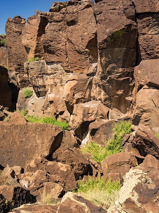
When we arrived we got off the bus and I slung my camera bag over my shoulder while Anne threw some water in her purse/backpack thingy. Phil asked if we didn’t want to take a walking stick, so we each grabbed one from the rack. Looking up at the cliff, I thought, “This will be fun.” I didn’t see an obvious way to get up there. After we were ready, Phil explained, “The trial over there used to be the only one until the archaeologist brought a drone to film the site a couple of years ago. After studying the films, they realized that there was a second path up the ledge, so we’re going to go up this way and come down on the old trail.” I wondered what he was talking about, I couldn’t see a trail in front of us much less the one over there. While we’re at it, I don’t see any ruins up there either!

Pottery Sherds
At the door Kiva’s door is a display of pottery sherds for you to examine. You’re welcome to pick them up and look closely, but please put them back so that others can have the same opportunity.

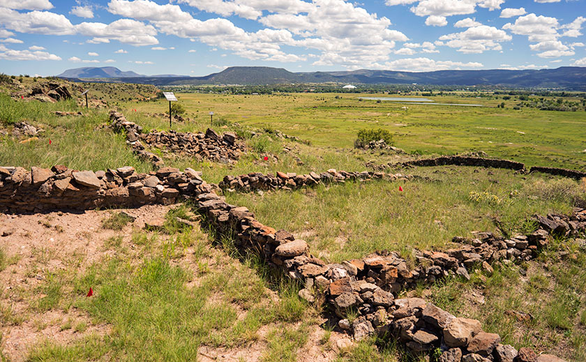
We started walking up where the bigger rocks were kicked aside until we got to flat rocks that were reinforced and cemented in place. Ah, a trail — I get it. We’d move forward until we got winded, and Phil would conveniently stop and find something to talk about long enough that we’d catch our breath. The walking stick helped me keep my balance with a camera on one shoulder and bag on the other. Before we knew it, we reached the Grand Kiva — a large meeting hall — with basalt stone walls four-foot tall and equally wide. We listened as Phil talked about two hundred men packed in the smoke-filled ceremonial room. Then we went up more steps till we got to the 150 room apartment house were we heard stories of the ancients and how the volunteers take care of it.

Casa Malpais Pueblo
The pueblo at Casa Malpais has over one hundred fifty rooms, some of which have never been excavated. In the background is the town of Springerville at the foot of the White Mountains.

As we walked around the pueblo’s back side, Phil took us aside toward the cliff wall. “This is the lost canyon,” he said pointing at where the lead edge of basalt columns had pulled away from the original cliff. “Jeff and I have explored back there,” he said in such a way that you knew he had a genuine love of this place. Then he showed us three rams head petroglyphs carved into the rocks. “That one marks the summer solstice, the one on the right is the spring equinox and the one in the middle lines up with the cross quarter.” I would never had seen them, much less got a photograph if we were on our own.

Lost Canyon
Behind the Pueblo is a place where the leading edge of basalt columns have pulled away from the cliff. See if you can find the three rams head petroglyphs carved into the rocks.

We spent two hours on the ledge listening to Phil explain what he knew and us asking questions like a couple of six-year-old. He answered what he could and was honest about what his speculations were. “I wish I could go back 800 years to know that answer, but my best guess is … ” Before we knew it, we were back at the bus. Neither of us had fallen and I hadn’t dropped anything into a bottomless crevice, so I counted the day a success. When I mentioned this, Phil said, “Yeah, last month I went out with four and came back with two. My boss said, this is not good.” On the drive back he told us that story. If you’d like to hear it, sign up for a tour and ask Phil.

VLA

Drive east from Springerville on U.S. Highway 60 for an hour and forty-five minutes and  you’ll be at the Karl G. Jansky Very Large Array. It’s a radio astronomy observatory with twenty-seven radio telescopes spread out across an ancient dry lake larger than New York City. You may have seen it in films, most notably Carl Sagan’s Contact staring Jodi Foster. That’s the day trip that Queen Anne and I took yesterday. It’s our third visit. We needed new T-shirts.

It was a perfect day for the road trip – cool, clear and sunny with puffy white clouds scattered about. U.S. 60 climbs out of Round Valley for a short stretch before reaching the high desert volcanic plains that distinguish eastern Arizona and western New Mexico. It’s covered in grass and pinion pine and changes to sage brush as you head east. The terrain is flat, but like a dinner dish. The road would rise to a lip revealing another bowl and the road was visible ten (maybe twenty) miles on the other side, dead straight ahead. “On a day and a road like this, … ” I started to say out loud. ” … you could drive forever,” Anne finished. We’ve been together far too long.

Datil Mountains
The Datils are a small range of mountains on the Continental Divide.

We didn’t see a lot of animals, just a smattering of cattle and a couple of horses. We did come across a small heard of elk cows with calves. They were grazing near the right side of the road, and raised their heads as Fritz passed. About an hour into the trip the road goes through a pass in the Datil Mountains. It’s a small range that separates the open spaces. The most notable thing about them was the road sign marking the Continental Divide. I had forgotten that we would cross it.

Radio Telescopes
The Very Large Array has 27 of these Radio Telescopes spread out over an are larger than New York City.

The VLA is in the basin below the Datils, and soon we arrived. The sight of all those large telescopes from the road makes you want to ease out of the throttle, but I knew the entrance was still a mile away so I left the cruise control on as we crossed over the rail road tracks on which the telescopes are moved. Finally we pulled into the entrance and headed to the visitors center.

Pronghorn Antelope
We saw this fellow as we left the VLA, minding his own business until I pulled out a camera.

The observatory is very visitor friendly. The center has National Park like displays explaining its mission along side some of the juicy discoveries they made. We watched their twenty-five minute film. Hardly anyone works there, it’s too remote. Instead the labs are fifty miles away in Socorro. There is a self guided tour that costs six bucks, but we got a dollar discount because we’re geezers. Guided bus tours come up from Socorro and we were lucky to run in to an astronomer waiting for a bus to arrive. He offered Anne and I a five minuet spiel then he’d answer our questions. “Have you heard from anyone yet?” I asked.

“We don’t do any SETI work at this site,” was Dale’s response and we both agreed that the movie gave a false impression on that point.

After spending a couple of hours at the VLA we packed our new T-shirts and started back. The light had ‘come in’ and I had all kinds of photo-stops to make, besides we could get some pie in Pie Town. After wasting some film we made it to Pie Town at 5:00, but all three of the cafes were closed (I really wanted some of that fine cherry pie). We continued to dally along the road and made it to the Ritz in time for sunset cocktails on our tree covered veranda. A most rewarding day indeed.

Ah, Joy

Oh, the joy of sleeping under the covers with the windows open. We’re in Eagar, Arizona – about four miles west of the New Mexico border. Outside, the temperature is a crisp fifty-two degrees. In Phoenix we won’t see these temperatures until Halloween. Queen Anne is still contentedly snoring in bed, so all’s quiet in the world. I see a cloudless sky through the window and the sun is about to clear the next door trailer which will make it all but impossible to type, so I’ll be quick about my report.

Yesterday’s trip was a pleasant and uneventful six hours. Two of those hours we spent traversing the Phoenix Metropolitan area to Fountain Hills where we stopped to top off the tank and buy some road food. We phone-waved Jeff as we passed his Scottsdale house. Not expecting our call, he offered to put shoes on and meet us for a bite, but we declined because we were already moving.

Fountain Hills is the point where I feel we’ve finally left town. From there we drove the Bee-Line Highway, climbing out of the Valley of the Sun to Payson’s 6000 foot elevation. We noted each time Fritz’s outside temperature indicator dropped from the low 90’s to the high 80’s. That doesn’t seem like a lot until you factor the hour and a half driving time. In Payson, we headed east on Arizona Route 260 and made the last ascent up the Mogollon Rim, and breaking through the 7000 foot elevation. From there, the rest of the way was a gentle descent. Our next way-point was Showlow and back on US Highway 60, ironically the same highway we took out of Wickenburg.

It was almost 3:00 pm when we reached Round Valley — a five-mile circular flat at the foot of the White Mountains — containing the yin yang towns of Springerville and Eagar. Springerville is on the north along US 60 while Eagar is on the south along AZ 260 with Main Street connecting the two highways (Yes, I know they’re the same roads, but there’s a method to my route madness that I’ll ‘splain someday). We stopped at the local Safeway for provisions and a bite to tide us over until dinner before checking into our campgrounds.

About our campgrounds … all I can say is that I’m glad that I went to Alaska last year. This place is somewhere between Watson Lake and Peace Park Gardens in Vancouver, but that’s a very large spectrum and I consider this in the bottom percentile. It’s certainly not a resort like where Fred and Deb are working. It is small and quiet with mostly permanent residences and few spaces for us transients. We picked it for the WiFi reviews and the price. The price reflects the lack of facilities (no showers). When we came in, the hosts had just finished helping a guest with a grand fifth-wheel (“The largest we’ve ever had,” he told me), before helping us with The Ritz (“The smallest one we’ve ever had”). Thanks … I guess. Anyway, behind The Ritz, we have a lovely private space under large Ash trees for sunset cocktails; how could things be better?

This morning. we’re going to spend time to lay out an itinerary for the week. We have a lot on our list and we need to rank it. One item on the list is the 2017 Great Mexican Food Springerville Shootout. Springerville has two restaurants that we like and we’re going to offer up our two cents on (last night’s dinner was at one of them — more later). We also need to spend the morning knocking off the rust on our camping skills, a fact that became obvious to us during set-up yesterday. The adventure awaits and I’ll have lots of photos for you.

Till then … jw

Eww, Bugs

Because we’re so snobbish, we don’t have trash pickup at our house. Instead, we toss the garbage and recycle into Fritz and drive up to the local refuse transfer station. It sounds like another chore, but we get pleasure out of dump runs by stopping off for breakfast while we’re out. There are three local restaurants we can choose from, and we choose which one to eat at depending on the hankering we have at the time. The Ranch House is in Yarnell at the top of the pass, and they have the best ham and eggs. The ham is so big it should come on its own plate and I always get a doggie box, because we can get two more meals out of it. Nichols West is our swanky joint and they probably serve the best Eggs Benedict in the county (if not the state). Finally, there’s the Arrowhead Bar and Grill — usually frequented by geezer bikers that are on a weekend road trip reliving the youth they wished they had. It’s the Plain-Jane of the trio, but it’s the most convenient and so we eat there most often.

Saturday was this week’s dump day and after unloading the truck and heading back, we pulled into Arrowhead’s parking lot. It was exactly 8:00 am and some people were standing in the parking lot talking. The door to the dining room had a sign saying it was closed, so Anne rolled the window down and asked the group what was going on. The group was the new owners having just bought the place two weeks ago. The wife explained that the dining area was infested with boxelder bugs, but the kitchen and bar were open. She added that the exterminator just left but the treatment would need some time for it to work. We considered leaving but they told us that the area was under siege, including the other two places that we frequent. Reluctantly we decided to risk it.

Boxelder bugs are beetles smaller than your pinky fingernail, and Wikipedia said that they get their name because they favor the tree of the same name. They winter over in the warmth of nearby structures by invading through cracks and crevices. You may see one or two of them occasionally, but they lay eggs in the millions that hatch at the same time. The swarm forms large mats of bugs on the warm side of rocks and buildings until they dry out. Then they fly back to good tasting vegetation nearby. I don’t know what they eat here because I don’t think boxelder trees grow in Arizona, but it must be good and plentiful, because (with all the rain we’ve had) there’s an exceptional hatch of bugs this year. They’re not aggressive and don’t bite, but like a mosquito, they can leave a mark if they think you’re food.

Boxelder Bud
The innocuous boxelder bug is harmless until they swarm in the millions.

We’ve seen other insect hatches on our morning walks. White flies, midges, no-see-ums, and those irritating mosquitoes. Early this summer while driving down our street, we drove through a bee swarm moving diagonally to the neighborhood. Until I figured out what they were, I thought it was a dust storm.

We tried to have breakfast at the bar and ordered our usual. As I drank my coffee and Anne her Diet Coke, we watched each other for bugs. Occasionally one would land on our tee-shirt and the other would brush it off. When they served breakfast, we hurriedly gulped it down before ‘the pepper’ moved on the plate. Before we could finish, our waitress came over and apologized and told us that they were closing. “The owners want to say they are sorry by comping your meal,” she said. We left a large tip and thanked them as we left.

On the way home, we had to stop at the Quickie Mart and Post Office. On each of those walls were large mats of bugs with others crawling away from the swarm. My hair is itching just writing about it. We live four miles down the road from town and nary a bug is found. I don’t know what we’d do if they invaded our house. Fortunately, they move on in a week and things go back to normal.

So the next time you think that humans rule the world, just remember insects were around before dinosaurs. Our 7.5 billion world population looks tiny in comparison. I’ll bet there are more boxelder bugs in Congress now. Enjoy your breakfast … watch the pepper closely.

Till then … jw

Springerville, Here We Come

It’s almost the middle of August. Queen Anne and I got our monthly allowance and paid the bills, but we have a couple of bucks left over and they’re burning a hole in our pockets, so we’re getting out-of-town for a week. The plan is to head for the hills … literally. To be precise, we’re off to Springerville and the White Mountains. Once again we’ll be camping in the trailer, or as my friend, Jeff once said, “We’ll be taking the Mercedes and spending a week in the Ritz.” That joke won’t be funny anymore if we ever get a different truck.

Normally we escape the desert’s heat at the north rim. We love going there because there’s nothing to do. So we pack all of our crap and do nothing for a week … except for sleep in the cool air, eat, snooze, drink,  slumber … and then take a nap. That was before we were doing this blog, and there’s no Wi-Fi up there. There’s also no radio, phone coverage, television or any other form of communication … well, maybe smoke signals, but I’m lost without auto-correct.

We picked Springerville — actually, the town of Eager which is next door — because it’s central to a lot of touristy stuff. We found a campground that (in reviews) has decent Wi-Fi, so we’re going to go play Tommy and Tammy Tourist and write about it … just like last summer. Won’t that be fun? I hope you’ll join us.

Rich Hill Rainbow
As an afternoon storm moves north, a rainbow touches a peak in the Weaver Range known as Rich Hill. Hmm.

PS: This is a new picture that I put up on my site a few moments ago. I hope you’re not tired of these storm photos because I’m having fun with them. It’s just a phase I’m going through, I’ll get over it.

What a Doozy

I’ve been reporting about this year’s monsoon season, how afternoon storms roll through here every other day, how they put on a great show, and how they have distinct personalities. Today I want to tell you about last Tuesday’s storm. It was a doozy!

August Storm
The clouds from Tuesday’s storm ran the full gamut of gray, from white to black.

The day started off normal enough, the Queen and I ran into town to do some errands and grab a bite of lunch. As we drove home, we noticed clouds building up in the west and south. We ignored them, because it’s rare that weather comes in from those directions. Since there wasn’t a lot of activity over the mountains that normally affect us, I figured that we’d have a quiet evening. When we got home, I laid down for a nap, but when I woke an hour later, the house was dark. The sun wasn’t streaming in the windows, so I stepped outside to check the skies. Everywhere I looked were storm clouds in every shade of gray; white to black. The most menacing patch was over the pass where Yarnell is. As I watched for a few minutes, I realized it was heading in our direction.

From Yarnell
As the winds pushed through the pass, they began to form vortexes like you often see on aircraft wing tips.

I’ve been having fun and some success shooting storms as they move in this summer. I was playing junior storm chaser and already had a couple of, as I call them, Mitch Dobrowner—light images, and here was another chance at dramatic weather shots. I grabbed my camera and walked down the street to the open desert. As I began clicking off frames, the darkest section of the front cleared the mountain range and began behave oddly. As it forced its way through the pass, it formed a vortex and began dropping in elevation. It looked like the spirals coming off Formula One wings during rain races. Behind the main thrust, the mountains disappeared in a curtain of black rain. Since the storm was closing fast, I started walking back to the house. Half way home, I turned for one last shot, and as the wind picked up, I could feel drops on my skin. When I got back to the house, I told Anne that we have to think about finding a safe place to hide should the storm spawn a tornado.

White House Before the Storm
As I made my way back to the house, I turned to take this shot. After I got home, I told Anne that we may need to find a safe place to hide.

The full force of the wind hit just as we were checking out the kitchen pantry. We watched the front tree blow back and forth brushing its limbs against the porch for a few minutes before we heard a pounding on the roof and kitchen sky light. It was too loud for rain, and we went out on the back deck we confirmed that hail was pelting the house. In a matter of minutes, the hail began to turn our red-rock drive to white, then just as quickly, a heavy rain started and washed the hail away. Even though we were on the leeward side of the house we got soaked because the wind whipped and swirled so the rain was coming in under the roof.

Lake What-a-muck-a
That’s not grain, it’s rain. In minutes the back yard went from rock to covered in hail and finally to Lake What-a-muck-a.

For a moment, I thought about getting my rain jacket and microphone out so I could pose like one of those idiot Weather Chanel reporters do in a hurricane, but I decided not to because I’d have to stand out in the wind, rain, and lightning. Besides, I don’t have a waterproof microphone. In a matter of minutes, the back yard turned into Lake What-a-muck-a.

Meanwhile, out front the streets were fast flowing, knee-deep rivers from curb to curb. The swift flowing water would have knocked you down if you attempted to wade across them. The streets were designed to drain to a wash that cuts through the park, but it was running beyond capacity and couldn’t take any more run-off.

Within an hour the wind and rain stopped. The thunder and lightning continued for a while but finally died as the storm moved south. Anne and I ventured out on the front porch and watched the water slowly recede uncovering sand bars. Neighbors ventured out of their homes and compared notes. Those that have rain gauges said they had 2-2.4 inches for the hour-long storm. I would guesstimate the wind gusts a conservative 60 mph. All of our water ran down the dry creeks to Wickenburg where the evening news had flooding stories.

While out walking the next morning, we were surprised there wasn’t more damage in the neighborhood. A handful of trees had broken limbs, some ocotillos were knocked over and some of the wash’s engineering suffered, but there wasn’t much structural damage. I had to mend some skirting, but that was it. Mostly the people we saw were busy shoveling dirt from the streets back into their yards. Not bad for the storm of the year.

Till then … jw

On Display at National Bank

I’m pleased to announce that my premier print Mt. Hayden is on display in the lobby of Wickenburg’s branch of the National Bank of Arizona. At 24 x 30 inches, it’s the largest framed print in my collection. It’s also notable because it’s entirely analog. That’s right, it was shot on film and printed the old fashion way; in a darkroom.

Mt. Hayden
Taken from the Grand Canyon’s North Rim, Mt. Hayden, at over 8000 feet in elevation, is one of the most recognizable canyon subjects.

I’d be pleased if you’d stop by National Bank and tell the folks that you came to see the Mt. Hayden print. The bank is at 540 West Wickenburg Way; just west of the railroad bridge, and they’re open normal banking hours. The print will remain on display until September 1st. Just for fun, ask if you get a free toaster with a new account.

Till then … jw