Garnet Mountain Picture of the Week

When I was a younger man, I had too many hobbies. Besides photography, I raced cars, fished, listened to music, and gorged on food and wine. Since retiring, we’ve downsized. I’ve given up cars, fishing, and expensive restaurants. We live on a pension now, so photography is my last indulgence—and it’s a good thing that I don’t have to buy film anymore, else I’d have to throw that out the window too.

It took a while to adapt to Arizona living. Sure, half the year is divine, but summers are hell—literally. So, as every good Zonie knows, you head for the hills to escape the heat and humidity of the monsoons. The other option is to close the drapes, lock the doors, and hibernate in front of the telly. As an aspiring angler, I bought a new edition of Bob Hirsch’s Best 100 Arizona Fishing Holes every year. They never changed, but I always read the ink off my copy by the time the Outdoors Show rolled around. I preferred fishing for trout instead of bass, so we’d make our pilgrimages to where the waters were cold: the Mogollon Rim, White Mountains, Lake Powell, or Lee’s Ferry—if the weather was good.

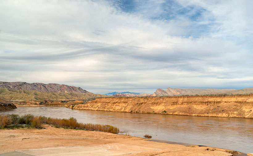
On the trip that Queen Anne and I made to Pierce Ferry for this month’s topic, I kept asking myself, “Why haven’t I been here before? This part of Arizona is beautiful and very photogenic.” I think the simple answer is that there are no trout here, so I didn’t care. Of course, there’s the Black Canyon below Hoover Dam, but it’s 675′ above sea level. That’s lower than Phoenix, and black rocks surround it. Besides, I got skunked on the one trip that we made, so I never went back.

Hualapai Valley, as I said, is Basin-and-Range topography—like Nevada. It’s flanked on the east by the southern end of the Grand Wash Cliffs, while the Cerbat Mountains line the west. The valley floor’s low spot is Red Lake—which is dry most of the year. Orchards surround the lake, but I don’t know how successful they are. Hualapai Valley is also home to a large grove of Joshua Trees, which fills an area about the same size as ours in Yavapai County.

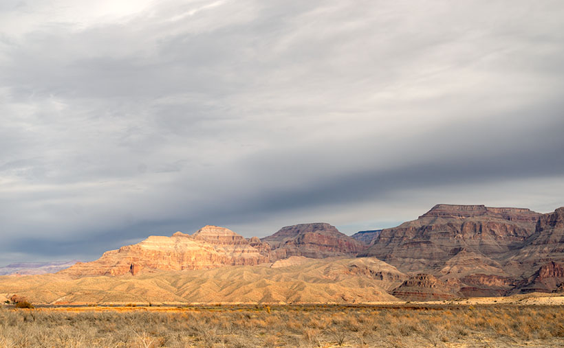
It’s the Grand Wash Cliffs that caught my attention on the map. They’re a long string of mountains—above and below the Colorado River, forming the western edge of the Colorado Plateau. They’re the transition to the Great Basin Desert.

Garnet Mountain - Joshua and sage grow to the foot of snow-covered Garnet Mountain.
Garnet Mountain – Joshua and sage grow to the foot of snow-covered Garnet Mountain.

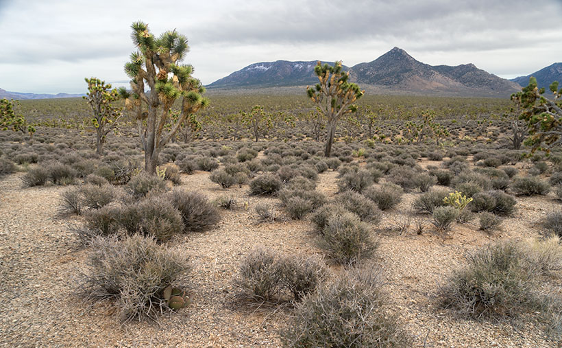
This week’s featured image, Garnet Mountain, shows Joshua Trees and sage growing to the mountain’s feet. The mountain is over 6,000 ft high and has snow from previous winter storms. The unnamed pointy peak is closer but a thousand feet shorter, so that’s why it’s not snow-capped. Together, they show two of the geological forces that shaped Arizona. Block shapes are generally uplifts caused by plate tectonics, while pointy mountains are usually volcanic. I like what we saw on this visit, so I’m planning a trip to the Colorado River’s north side later this year, but to do that, I’ll need to travel via Utah or Nevada, so I’ll need some slot machine money.

You can see a larger version of Garnet Mountain on its Web Page by clicking here. I hope you enjoy seeing it. Join us next week as we drive home and stop for more photos.

Until next time — jw

Grand Wash Cliffs Picture of the Week

I love those DeLorme Atlas & Gazetteers. I have about a dozen of them stashed on my office bookshelf, one for each state that we’ve traveled. Whenever Anne and I go on one of our jaunts, I toss at least one in the truck. I try to be careful with them, so they’ll last, but I’m regularly replacing my Arizona edition because I use it so often.

Last month while looking for new places to explore, I realized that there are four pages in the Arizona Gazetteer where I’ve never been, not in the 48 years that I’ve called Arizona home. The pages are easy to find, as they’re the first two and the last two. The areas covered by these pages are The Arizona Strip—east of Nevada and south of Utah north of the Colorado River—and the southeast corner of the state. I’ve never been to the Chiricahuas. Isn’t that hard to believe? I’ve decided to fix that by making trips to our northwest this year, and the southeast corner next year.

With that in mind, February’s topic will be the trip that her majesty and I made to Pearce Ferry this week. It’s not a difficult trip as you get off Interstate 40 on Kingman’s Stockton Hill Road. You go 40 miles north on that road, then you turn right on the Pearce Ferry Road and continue until the Colorado River stops you at the other end. All but the last nine miles are paved.

What you’ll see along the way is the Great Basin Desert. More like Nevada than the Sonoran Desert that we’re used to. Stockton Hill Road runs along the east side of the Hualapai Valley and Red Lake—one of the four natural lakes in Arizona. In winter, it even comes with water, the rest of the time it’s dry. The Pearce Ferry Road section crosses the valley and runs along the Grand Wash Cliffs to Meadview. That’s where the gravel-dirt road descends to the River.

Grand Wash Cliffs - A storm front moves over the Grand Wash Cliffs at Pearce Ferry.
Grand Wash Cliffs – A storm front moves over the Grand Wash Cliffs at Pearce Ferry.

Besides the towering Grand Wash Cliffs and muddy Colorado emerging from the Grand Canyon, there’s nothing much happening at the Ferry. Until a couple of years ago, it was the place where Grand Canyon rafters hauled out of Lake Mead. Because of the ongoing drought, the lake is so low that the boat ramp is high and dry. Now boaters have to use South Cove. It’s 23 miles away by road, but double that by water.

I took this week’s featured image near the deserted boat ramp. It shows the colorful Grand Wash Cliffs under a brooding sky. The storm front that you see greeted us on our arrival and followed us home, bringing rain to Congress the next day. I call this image Grand Wash Cliffs (At Pearce Ferry).

I’m also including a second image this week at no extra charge. I wanted to show the boat ramp struggling to reach the muddy river. The next launching place is at South Cove around the peninsula in the photo’s background. By the time the river passes South Cove, the river flows into Lake Mead, and most of the silt drops out of the water, so its color is blue (and high white banks because of the low water level). This second photo is for reference, so I called it Dry Ramp.

Pearce Ferry Boat Ramp - Lake Mead's water is low enough that the boat ramp isn't usable.
Pearce Ferry Boat Ramp – Lake Mead’s water is low enough that the boat ramp isn’t usable.

You can see a larger version of Grand Wash Cliffs on its Web Page by clicking here. I hope you enjoy seeing it. Join us next week as we drive home with stops along the way to photograph more lovely scenery in Hualapai Valley.

Until next time — jw