Garnet Mountain Picture of the Week

When I was a younger man, I had too many hobbies. Besides photography, I raced cars, fished, listened to music, and gorged on food and wine. Since retiring, we’ve downsized. I’ve given up cars, fishing, and expensive restaurants. We live on a pension now, so photography is my last indulgence—and it’s a good thing that I don’t have to buy film anymore, else I’d have to throw that out the window too.

It took a while to adapt to Arizona living. Sure, half the year is divine, but summers are hell—literally. So, as every good Zonie knows, you head for the hills to escape the heat and humidity of the monsoons. The other option is to close the drapes, lock the doors, and hibernate in front of the telly. As an aspiring angler, I bought a new edition of Bob Hirsch’s Best 100 Arizona Fishing Holes every year. They never changed, but I always read the ink off my copy by the time the Outdoors Show rolled around. I preferred fishing for trout instead of bass, so we’d make our pilgrimages to where the waters were cold: the Mogollon Rim, White Mountains, Lake Powell, or Lee’s Ferry—if the weather was good.

On the trip that Queen Anne and I made to Pierce Ferry for this month’s topic, I kept asking myself, “Why haven’t I been here before? This part of Arizona is beautiful and very photogenic.” I think the simple answer is that there are no trout here, so I didn’t care. Of course, there’s the Black Canyon below Hoover Dam, but it’s 675′ above sea level. That’s lower than Phoenix, and black rocks surround it. Besides, I got skunked on the one trip that we made, so I never went back.

Hualapai Valley, as I said, is Basin-and-Range topography—like Nevada. It’s flanked on the east by the southern end of the Grand Wash Cliffs, while the Cerbat Mountains line the west. The valley floor’s low spot is Red Lake—which is dry most of the year. Orchards surround the lake, but I don’t know how successful they are. Hualapai Valley is also home to a large grove of Joshua Trees, which fills an area about the same size as ours in Yavapai County.

It’s the Grand Wash Cliffs that caught my attention on the map. They’re a long string of mountains—above and below the Colorado River, forming the western edge of the Colorado Plateau. They’re the transition to the Great Basin Desert.
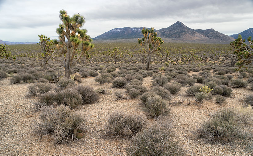
Garnet Mountain - Joshua and sage grow to the foot of snow-covered Garnet Mountain.
Garnet Mountain – Joshua and sage grow to the foot of snow-covered Garnet Mountain.

This week’s featured image, Garnet Mountain, shows Joshua Trees and sage growing to the mountain’s feet. The mountain is over 6,000 ft high and has snow from previous winter storms. The unnamed pointy peak is closer but a thousand feet shorter, so that’s why it’s not snow-capped. Together, they show two of the geological forces that shaped Arizona. Block shapes are generally uplifts caused by plate tectonics, while pointy mountains are usually volcanic. I like what we saw on this visit, so I’m planning a trip to the Colorado River’s north side later this year, but to do that, I’ll need to travel via Utah or Nevada, so I’ll need some slot machine money.

You can see a larger version of Garnet Mountain on its Web Page by clicking here. I hope you enjoy seeing it. Join us next week as we drive home and stop for more photos.

Until next time — jw

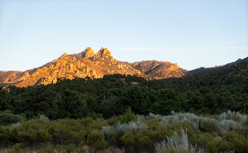
Dean Peak Picture of the Week

Dean Peak
Dean Peak – One of several points in the Hualapais over 7,000′. I captured this as the sun was setting and the rest of the mountain was in shade.

There’s a Prime Video series Queen Anne, and I watched this month called Good Omens. We enjoyed it so much that we watched it a second time, and caught a lot of the subtler jokes that we missed the first time. The main characters—an angel and his demon buddy—aren’t very good at their jobs, and consequently, they screw up Armageddon. This riddle was in an episode, “How many angels can dance on the head of a pin?” It’s a trick question because as God—the voice of Frances McDormand—explains; Angels don’t dance, that’s something the devil conjured, and there’s not a substantial enough number to count them all, because demons can line-dance in the spaces between the pin’s atoms—funny stuff. When I visited this month’s photo location, I thought about the show’s riddle.

For my August pictures, I only had to walk across the street—as such. My new subject is the mountain range on the west side of the Big Sandy River and U.S. Highway 93—the Hualapai Range. They’re part of the parallel mountain ranges making the Basin and Range Domain which runs from Utah to the California Sierras. From space, these formations look like a pack of caterpillars stampeding across a sidewalk.

The Hualapai’s are a twin to last month’s Aquarius Mountains, except they are high enough—7,000 to 8,400—for pinion and ponderosa pine to grow. That means they are often snow-covered in winter. They fill the area between Wikiup and Kingman.

When my folks lived in Kingman, I heard of a park up on the mountain, but never visited, so last week I loaded Archie and drove up Sawmill Canyon Road (alas, if there was a sawmill, it’s gone now). The DW Ranch Road exit on Interstate 40 is a handy shortcut to use if you’re coming from the valley. It’s less than 10 miles from the Interstate to the County Park which is situated in a tiny valley at the top, and where Kingman residents have packed summer cabins into every available space. As I drove along the deeply rutted streets, I wondered, “How many Ford executives can camp on the top of Hualapai Peak?” In the village’s center, there is a concrete catch basin that’s called Pine Lake, but I couldn’t find public access to it, and—from its color—I’m not sure you would want access anyway. I got frustrated at having to back out of each street I tried and decided to check out the Hualapai Mountain Park and campgrounds.

After paying a day fee, I parked in the trailhead parking lot and checked out the maps. It was already after five when I started on the path to Stair Step Overlook, about a half-mile hike. I was never athletic, and I don’t claim to be in great shape today. I grew up uncoordinated, and when I was a kid, I was always the last pick for team sports. But, I regularly walk now, and my average speed is over two miles an hour. I figured a 15-minute walk at the most, so I grabbed my camera and left my water in the truck. I was wrong. It took 10 minutes—coming back down the mountain. The trail climbed four-hundred feet in that half-mile. As I hiked, I followed a group of two men and a woman who were in their early thirties and equipped with day-packs. I followed them inch-worm style; they walked out of my sight and then they’d be resting when I caught up.

When I finally got to the overlook, my new hiking friends were lounging on large granite slabs and taking in the view. As I climbed up the stairs, I looked up to see six of them before my eyes could focus again. The woman looked concerned and asked, “Do you need water?”

“No,” I replied. “I only wanted to get here and take some pictures. I’m going back down right after that.”

Then the guy with the beard drove a stake through my heart, “Man! I hope that I can be hiking up and down some mountainside when I get as old as you are.”

I did get a shot from the overlook, but I took this week’s featured image on the drive home. I call it Dean Peak because that’s what this point’s name is. When I took this shot, the sun was almost down, and the lower part of the mountain was already in the shade. I hope you enjoy viewing it.

You can see a larger version of Dean Peak on its Web Page by clicking here. Be sure to come back next week when we’ll be showing more from the Hualapai Mountains.

Until next time — jw