Mohan Range: A Lost Horizon in Arizona’s Bermuda Triangle Picture of the Week

Have you ever looked at an Arizona road map and noticed the big empty swaths—entire regions with no towns, no intersections, no welcome signs? A third of the state looks uninhabited. That’s not cartographic laziness—it’s the truth. Some places were never meant for people. Look at a land-ownership map and you’ll understand why. Much of the terrain south of I-8 is military proving ground (because what better use is there for a desert than dropping bombs?). To the north, you’ve got the Grand Canyon and vast stretches of tribal land. And over in the west—well, welcome to the Bermuda Triangle of Arizona.

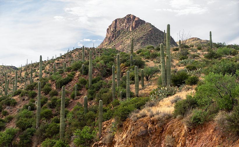
Three roads trace its edges: U.S. 93 on the west, I-40 to the north, and Arizona 89 on the east. Unlike the Sahara-style sandscapes you might expect, this isn’t a wasteland. The land rolls between 3,000 and 10,000 feet in elevation, a mix of grasslands and mountains. It gets summer monsoons—thunderheads stack up there most afternoons. It looks like it should be dotted with towns.

But it’s not.

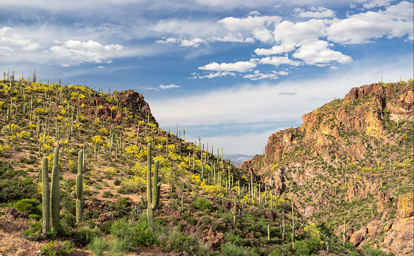
This month, I decided to poke around this odd no-man’s-land. I set my sights on the Aquarius Mountains, taking Upper Trout Creek Road—a little loop that climbs over a saddle and drops down the far side before ending at a quiet religious retreat. There’s a parking area where I stopped, took in the view, and turned around. That’s where I captured this month’s image: Mohan Range.


Mohan Range-Very few know or have visited the Mohan Mountains in Arizona.
Named by the scouts of General Crook, the Mohan Range whispers of forgotten trails and undisturbed land—where silence stretches further than the road.

The Mountains You’ve Never Heard Of

I hadn’t either. You don’t see the Mohan Range from U.S. 93—it’s tucked behind the Aquarius Mountains. But it’s real. Mohan Peak stands at a respectable 7,500 feet, putting it in Arizona’s top 100 summits. From Interstate 40 or some spots in Prescott, it’s visible—if you know where to look.

Naturally, I came home and Googled it. I expected to find a line or two. Instead, I struck gold.

One of the first search hits was from the Peakbaggers website. These folks climb the top 100 mountains in each state—for fun. (No, I don’t understand them either.) But their post was solid: detailed, well-written, and packed with photos. That page led me to something even better—a beautifully photographed article by Kathy McCraine about the O RO Ranch.

A Quarter Million Acres of Off-Limits

So why aren’t there any towns in this triangle? Because nearly all of it—over 250,000 acres—is the O RO Ranch. It’s private, and it’s vast. This is cowboy country, in the old sense of the word. The eastern part of the ranch stems from an original Spanish land grant—the Baca Grant, which the U.S. government actually honored. Later, the Mohan Ranch to the west was folded in, and the two became one: Arizona’s oldest and largest cattle operation.

According to McCraine, life here hasn’t changed much. Cowboys still ride the range on horseback and sleep in teepees. There’s no town, no road system, and definitely no Starbucks. And they don’t want company.

I loved one line she wrote:
“Cowboy wannabes need not apply.”

Take the hint. If you’re driving through, heed the signs. This is not a place for sightseeing unless you’ve got an invite, a saddle, and some serious grit.

The Road Less Photographed

You can see a larger version of Mohan Range on its web page here. And as always, we hope you’ll come back next month for another installment of Arizona’s overlooked corners and dusty crossroads. There’s something special about these places—where history lingers, maps go blank, and the silence stretches for miles.

Until then, keep your spirits high and your humor dry.
—jw


AD Wash Gap Picture of the Week

This month’s photo topic is Castle Hot Springs Road—part of my long-term project of getting off the highways to explore Arizona’s back roads. My only restriction is that the roads are accessible by regular passenger cars. That’s because I don’t want to buy some dune buggy for the project (Actual Read: Queen Anne won’t let me buy one).

Since I live on its west, Castle Hot Springs Road starts in Morristown at its junction with U.S. Highway 60—Grand Avenue. It loops northeast from Arizona State Route 74—which we always called Carefree Highway, but I see that it’s officially listed as Morristown-New River Highway—past the Wickenburg Mountains into the Buckhorn Range before it returns to SR 74 via the bed of Castle Creek through the Hieroglyphic Mountains. Its length is less than thirty-five miles, and you can use a pick-up truck because most of it is well-graded and broad. Its roughest section is on the east side, the several miles between Lake Pleasant and the resort, because it travels in the creek bottom. So, if you want to drive your Lamborghini to the Castle Hot Springs resort, take the clockwise direction from Morristown.

As I’ve said through the years,  people build highways from roads, roads on trails, and trails from paths, so you shouldn’t be surprised that some of the Castle Hot Springs Road originated from the Wickenburg stagecoach route. “Why travel through the mountains when there’s a straight shot across the desert floor?” you may ask. Remember, stages needed water for both passengers and horses. The trip took all day at best. On the west side, some parts of the original stagecoach road remain, and you can drive them, but you need an ATV or Jeep for that.

AD Wash Gap
AD Wash Gap–The AD Wash drains the local mountain and runs by the road before turning into a narrow canyon and eventually becoming part of Castle Springs. You get a peek of the Bradshaw Mountains in the distance in the gap.

This week’s image comes from the road’s west section, a mile up the road from last week’s photo. On the north side of the mountain seen in that photo, Rincon Spring feeds a runoff called AD Wash—there’s no reference to what the name means, even in my trusty Arizona Place Names. The wash drains the local mountain and feeds the Layton tank before it turns and flows through a canyon between the hills. On the other side, AD Wash drops a couple hundred feet into Castle Creek.

When I shot this photo, I wanted to capture the saguaro grove against the canyon’s jagged edges in the late afternoon light. When I saw it on my computer, I was pleased with the paloverde in bloom and the blue streak running through the cloudy sky. For those unfamiliar with our Sonoran Desert, the saguaros in this photo range from 40 to 60 feet tall, and that should help set a sense of scale to what you’re viewing.

You can see a larger version of AD Wash Gap on its Web Page by clicking here. Be sure to return next week when we see another beautiful stop I made on my Castle Hot Spring Road outing.

Until next time — jw

Bitter Creek Saguaros Picture of the Week

Queen Anne and I spent yesterday changing the house calendars, and with a new month, it’s time for a new photo project. I’ve been struggling to come up with an ongoing long-term theme—something similar to last years where we took you from town to town within Yavapai County. I considered several options—all of which I crossed off because they involved exercise and the possibility of having my mug broadcast on a Silver Alert.

To find inspiration, as I frequently do, I grabbed my Arizona Gazetteer Map, went into the library, and scoured through it until my legs fell asleep. In the maps, I saw something that would be interesting as a basis for a long term project. I noticed that there are roads—secondary unpaved roads—all over the state. They’re like the ones around my neighborhood that are well graded and can be traveled in ordinary sedans (in dry weather). For Archie—my four-wheel SUV—they’re freeways. These back-roads go to places I’ve never seen, and because they’re not meant for speed, almost all of you haven’t been on them either. Some of them are dead ends, some lead up into the mountains, and some head off across the desert. Haven’t you ever drive past some side road and think, “I wonder where that goes?”

So, that’s what I plan to take on for a while. I’ll pick a back road and see if it leads to something pretty or novel. Maybe I’ll eventually collect enough material and produce a catalog or magazine of sorts, but I’ll worry about that later. I can always suspend this project when I come across something fresh or different. You might say that this blog, newsletter, or whatever you want to call it, is going from On the Road to Off the Beaten Path.

Conveniently, I had a head start, because a couple of weeks ago, I took my camera and headed up Castle Hot Springs Road. It’s the long way between Lake Pleasant and Morristown, and the only way you can get to the newly reopened Castle Hot Springs Resort where Clark Gable stayed (we’ll talk more about that in another post). The road winds its way through the Wickenburg Range, Buckhorn Range, around the Hell’s Gate Wilderness, and past several working ranches, so there’s lots of eye-candy along the way.

Large saguaros march up the side of an unnamed mountain.
Bitter Creek Saguaros–Large saguaros march up the side of an unnamed mountain.

This week’s featured image comes from the area where the road runs through Bitter Creek. The 3700’ mountain is unnamed, and I was struck at how the saguaros grew thick along its flank to the top. At the base of the mountain’s north side, there is a ranch labeled 11 L on my topo map and a water hole named Layton Tank. I like how the vertical cacti resemble the crowds climbing Mt. Everest we’ve seen in the news lately. I’m also pleased that the clouds parted enough to add texture to the sky. I called this image Bitter Creek Saguaros.

You can see a larger version of Bitter Creek Saguaros on its Web Page by clicking here. Be sure to come back next week when we’ll see another beautiful scene I shot on my Castle Hot Spring Road outing.

Until next time — jw

Lava Tube and Brittlebush Picture of the Week

Everywhere I look, the desert is yellow, and it’s as thick as a jungle out there. When Queen Anne and I run into town, the train tracks—only a block from the road—are hidden behind the dense foliage. I supposed this was predictable with the good rains we had this winter. We had a good crop of poppies this month along with purple lupine and orange mallow lining the highways.

Several plants give to the yellow with the first to bloom is the Brittlebush. Their soft yellow flowers look like small pale yellow daisies on stems rising from sage-green leaves. Unlike the poppies, their color isn’t vibrant, but they’re so pervasive that they’ll turn mountainsides yellow. They thrive in disturbed soil, like the highway shoulders.

Creosote bush adds a second note of yellow. The lowly creosote is like the lawn of the desert, except it grows 4-6 feet high. A couple of weeks ago, the field across from the park was Kelly green. The bush’s flower is small—almost like buds, and now that they’ve popped, the green has a golden tint.

The yellow crescendo comes when the Palo Verde bloom. Last week, Her Majesty and I ran down to our dentist at the border, and along the way, the trees were already blooming in the low-lands. The bloom moves through the desert like an opening curtain into the highlands. Today I see the trees in our park are beginning to show the tiny flowers. At their peak, the Palo Verde dot the mountainsides with yellow splotches. It’s then you realize that they’re growing everywhere. There’s a color symphony, and quail provide the background music with calls as they stake out their territory. It’s the best time to live in the Sonoran Desert.

Lava Tube and Brittlebush
Lava Tube and Brittlebush – Three of the flowering plants grow among the rocks below a lava tube.

When Fred and I were out taking photos in Black Canyon a couple of weeks ago, I saw lots of brittlebush growing in the lava rock cracks. Their soft yellow popped against the dark, almost black canyon walls. Since they screamed, “Spring,” I wanted to capture the contrast. Out of the several shots that I took, I liked this week’s image best.

In the shot that I call Lava Tube and Brittlebush, three plants were growing below a gaping void in the rocks. I believe it’s a tunnel that formed when the molten magma lost pressure then receded. It’s just like when you were little, and your older brother tortured you by pinning you to the floor then drooled over your face but sucked the spit back at the last moment. The threat was always worse than the spit. Oh! By the way, on your first desert visit, inevitably someone will tell you, “Don’t sick your hand into any place you can’t see.” The lava tube is an excellent example of what they mean. I tried to get Fred to see if he could find any rattlers in there, but he refused. He was no fun at all.

Oh, if you’re wondering how brittlebush got the name, here’s an example of how they look after a couple of weeks without water.

You can see a larger version of Lava Tube and Brittle Bush on its Web Page by clicking here. I hope you enjoy viewing this week’s post and next week; we’ll show another featured image from a different Arizona site.

Until next time — jw

Black Canyon Rocks Picture of the Week

The Sonoran Desert is at its best in April, when spring drags everything back to life. The cactus bloom, mesquite trees put out new leaves, palo verde trees turn yellow, the animals are horny, and there are dead snakes all over the highway. Each year we don’t have to run the air conditioning or the heater for two months. We manage the house temperature by strategically opening or closing the windows during the day. But, along with the beauty and rebirth, we dread the coming heat with being stuck indoors and up to our eyeballs in power company debt. It’s like having sex and then a kid.

Arizona has always been hot—well, maybe except for the millions of years when it was a sea bed, but that was a fleeting moment. Not all the heat was from the weather. Our state is a hot spot for volcanic activity. We have over 600 sites of volcanic mountains, cinder cones, shield volcanoes, lava flows, and lava fields. Our two tallest mountains—Mt. Humphries in the San Francisco Peaks and Mt. Baldy in the White Mountains—are volcanoes that spewed ash, cinders, and pyroclastic flows at the same time (talk about dual exhaust). Not all the activity is ancient history. The most recent eruption was about a thousand years ago, and it’s not over yet. Geologists say there’s a 13% chance that another outbreak will happen in the next millennium.

As a photographer, all of these bumps, cracks, warts, and irregularities are what makes Arizona such a remarkable subject for pictures. I’m sure the millions of people who come and stand at the edge of our big ditch in the north would agree. So, what does all this have to do with my self-assigned Nothing project? I’m glad you asked.

As you travel north from the Nothing pass, Highway US 93 makes a downhill run to the bridges at Burro Creek, and on each side of the road is a small lava field that doesn’t have a name (according to my references). It must be ancient because it has enough vegetation that blends with the surrounding landscape. Along the flow’s southwest border, there is a spring and wash that carved a ravine through the lava bed called Black Canyon. It was this landmark that Fred and I set off to explore last week before getting distracted by George’s Camp—ooh, squirrel.

Black Canyon is easy to find from George’s because its mouth is next to the property—across the street if you will. Within a few steps, we began hiking up a wash that had cut through the dark basalt lava. As we continued, the walls grew higher, and big, water-polished basalt boulders littered the oatmeal colored sand. Their smooth surface contrasted with the rectangular blocks making up the canyon sides. Even though we walked in deep dry sand, it was clear that a lot of water must flow along the course. When wet, the dark gray boulders turn jet black which would be something to see, but since some of them were over my head, I’d prefer the higher ground.

Black Canyon Rocks
Black Canyon Rocks – Large pieces of lava that have fallen to the wash bed has been polished smooth by eons of water flow.

For this week’s featured image, I wanted to show the artistically placed smooth boulders contrasting the canyon walls. And I wanted to show the layers of textures: sand, worn stone, and rough wall. I also like the smaller white quartz placed within the basalt arrangements. Although I wasn’t paying attention to it, the mesquite’s bright new spring foliage adds dramatic color to the otherwise monochrome scene. I named this image Black Canyon Rocks.

You can see a larger version of Black Canyon Rocks on its Web Page by clicking here. I hope you enjoy viewing this week’s post and next week; we’ll show another featured image from Nothing.

Until next time — jw