I began writing a post for this week’s picture and wondered how cow skulls (horns) and car hoods became a thing. It seemed to originate in Texas. My earliest recollection of the meme was a red ’59 Caddy convertible with a Longhorn hood ornament—or maybe that was JR’s car in Dallas. As a car guy, I never understood why you’d tacky up a perfect vehicle with bovine parts. I guess it symbolized decadent wealth—that you had so much money you could thumb your nose at decorum—a new money thing.
Then, the genre moved to New Mexico, and the horns became a whole skull. Often, the cow’s head is hand-painted or jewel-encrusted. The cars changed too. They were no longer shiny new Cadillacs but heaps from the fifties with rust and dull patina. The whole car-cow thing transitioned from tackiness to art.
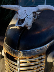
Chevy Skull – A cow skull decorates the hood of an era Chevy Truck and whispers tales of cattle ranching during the Second World War in Seligman.
While photographing Seligman, I saw this Chevy truck with a cow skull on the hood; I didn’t bat an eye and thought, “This seems perfectly normal.” Now that I look at this week’s image, I don’t think the skull is even mounted—it’s just sitting there as decoration. Interestingly, each object in the photograph would tell its own story, but combined, they conjure up an entirely different tale. I imagine a narrative of round-ups, chuck wagons, miles of open range, and nights under the stars. I guess it’s a story about a rancher growing beef during the Second World War and how hard his life was.
Sometimes, when I walk away from shooting an image like this, I have a hunch that it’s a good shot, and I can’t wait to see it on paper. This one, however, didn’t stand out in my memory. It wasn’t until I saw it on my computer screen that I considered it a keeper. It’s not about the skull but how the sunrise falls on the truck’s grill. The head balances the dark area in the composition. I named this image Chevy Skull.
Click here to see a larger version of Chevy Skull on its Web Page. I hope you enjoy viewing this week’s post and return next week when we show another featured image from Seligman and Route 66.
When I go to a new town like Seligman, I’m like any other visitor. I take in the bright lights and displays along the main street. After all, that’s the show. The merchants want to attract you into their stores. It makes good business sense. The old maxims counsel you to, “Put your best face (foot) forward,” and “Show your better side.” They can’t make a living if no one comes in. That’s why the storefronts are updated continuously with fresh paint, displays, and signs.
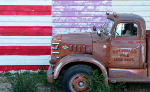
Fire Flag – A retired Seligman fire truck sits along a clapboard store.
But sometimes there’s good stuff out back, and that’s why I walk a new town’s back streets and alleys. They aren’t all spit-polished, and you can see a building’s structure untouched since it was new. If you’re looking for history or art, an alley is more rewarding because merchants ignore it.
That’s how I found the subject for this week’s featured image. It wasn’t behind but along a clapboard-sided store. It has a big faded hand-painted flag and retired fire truck which could be a museum display. The mural alone was a good shot as was the fire engine, but I decided to go for a twofer. The block of purple is a mystery, but it works in the photo. I named this image Fire Flag because it was a short, catchy description of the image.
You can see a larger version of Fire Flag on its Web Page by clicking here. I hope you enjoy viewing this week’s post and come back next week when we’ll show another featured image from Seligman and Route 66.
Any discussion about Black Canyon City wouldn’t be complete without mentioning Rock Springs, so I saved that for last this month. It’s hard for me to know where to begin. If you say that name, most Phoenicians will think about the pie restaurant. It’s understandable, it’s been open for a century now, and every time we drive by and think about stopping, we don’t because it’s packed. Like Yogi Berra said,” Nobody goes there anymore, because it’s too crowded.” As for lasting 100 years, I’d like to extend my congratulations, but I don’t want to talk about pies, I want to discuss its history.
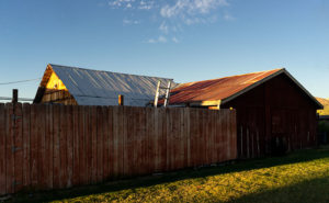
Out Buildings – A pair of tin roofs on storage sheds behind the Rock Springs Cafe.
Before cars, trains or airplanes—when I was a child—travelers stopped at Rock Springs because it was a reliable source of good water. People came here for centuries before Caucasians lived in Arizona. On your next visit, take the time to stroll around the grounds and look for the Waterfall signs. Outback, you’ll see water drizzling over polished and worn boulders—that’s Rock Springs. The restaurant has a couple of tables out there so you can enjoy a waterside cocktail. I imagine that the flow over the falls is pretty good at times, but when it’s dry, it’s more like forgetting to turn off your garden hose.
The water is the reason that Ben Warner opened a tent-like store, and—in 1918—built a hotel on this site. In case you didn’t notice, I love these historical buildings. Fortunately, the café has a Web Page that speaks of its history and shows an old photo of the block building—with an A-1 Beer sign hanging from the portico. I really wanted to capture an image of that hotel and talk about some of its famous guests; like Jean Harlow, Tom Mix, and Wyatt Earp. I couldn’t. Decades of hastily planned expansions have camouflaged the original building. Only hints of the original hotel sick out here and there. After circling the restaurant as the sun rose, I gave up and shot other subjects.
On one of my laps, I saw this interesting pattern of weathered tin roofs on a couple of storage sheds behind the Rock Creek Café. It’s as if they knew that I would be shooting this because they built a simple plank fence that masks the clutter and adds a perspective line to the scene. When I took this shot, I honestly didn’t pay attention to the clouds, but let’s not tell anyone. I’ll claim that I planned it. I call this week’s image: Out Buildings.
You can see a larger version of Out Buildings on its Web Page by clicking here. I hope you enjoy viewing this week’s post and come back next week when we begin a new monthly series from a different place in Yavapai County.
This week’s story has all the ingredients of a great Hollywood western movie: plantations, young love, war, drugs and alcohol, heartbreak, gold, bright futures, despair, stage robbery, friendship, false accusations, and tragic death. I don’t know how I can tell it all in 500 words and still explain my weekly photograph by the third paragraph. I’ve found several books and articles about Jack Swilling, but there haven’t been any films. That’s a shame because I can visualize told in the fashion of the Steve McQueen movie Tom Horn.
Swilling Cabin Window – Jack and Trinidad’s cabin ruins in Black Canyon City are on private property, and its caring owners are its only protection.
Every school kid in Phoenix knows how Jack Swilling—or one of his friends and crew, Phillip Duppa—tossed out the mythical bird’s name for the small town they were developing. For the rest of you, Swilling filed a land claim around present-day 32nd Street and Van Buren Road. He wanted to grow hay to sell to the cavalry at Fort McDowell, so he copied the Hohokam method of using Salt River water for the fields by digging new canals to his property. The visionary Swilling (I suggest casting a 20-year-old Jeff Bridges) played an essential role in the layout and alignment of the new town. A couple of years later he lost interest when the council—or whoever decided those things back then—moved downtown three miles west to its present site. Jack threw his hand up in disgust and he and his wife, Trinidad (my casting idea would be a 17-year-old Natalie Wood), moved to Gillett—a mining ghost town three miles south of Black Canyon City.
In Gillett, they built a cabin along the stage route and provided travelers and horses food, water, and rest. It helped to supplement his paultry mining income. His health was failing from old head and bullet wounds he got as a younger man. He took morphine and drank whiskey to counter the constant pain, but now the drinking got worse. When he got word that Colonel Jacob Snively—his old Indian war buddy—was killed near Wickenburg by Apaches, Trinidad encouraged him to retrieve the body and give Jacob a proper burial. Jack enlisted the help of a couple of neighbors and rode out to recover his friend. During that same three-day period, a stagecoach was robbed—also in Wickenburg—and the robbers murdered everyone on board. After Jack returned and buried his friend, he was at the bar when he heard about the stagecoach massacre. Jack cracked a joke about how robbing the stage is the only way to make big money these days, and the vague description of the robbers could include his retrieval party. They were arrested on the spot and shipped off to Prescott for trial. Since the Feds had charged him too, the territorial government dropped their complaints to save money. The marshalls transferred Swilling to the Yuma prison where his health took a turn for the worst, and he died before his trial. Shortly after his death, the law identified and caught the real robbers. Jack was already buried in the Yuma Prison cemetery before they notified Trinidad of his death.
When I decided that October’s subject would be Black Canyon City, I did my research, and there, I discovered the cabin ruins were in town. I wanted to photograph them, but they’re not on a map. That’s because they’re on private property and not open to the public. I stopped and talked to the tourist info people, and they gave me directions to the house, and when I drove up to the residence, the owner came out and chatted with me. When her parents built her home, they bought adjoining lots so that the stacked-stone cabin could remain intact. Black Canyon City doesn’t protect historic sites as other cities do, so they took that task upon themselves. She gave me permission to roam the property and to photograph the cabin with two caveats: don’t lean on the walls—they’re fragile and will quickly crumble, and don’t take any of the artifacts she has on display. A very reasonable request, I’d say.
Of the shots I took, I liked this variation best because of the window and the light filtering through the mesquite trees. Jack’s one-room cabin may not seem like the palace that the Father of Phoenix (and Mother) should have lived in, but just examining the rock-work made my sciatica nerve go off. It’s on a quiet cul-de-sac surrounded by modern homes near the Agua Fria River. I stood for a while and listened to the breeze blowing through the tree canopy, and I could see how it might have been to live there a century and a half ago.
You can see a larger version of Swilling Cabin Window on its Web Page by clicking here. I hope you enjoy viewing this week’s post and come back next week when we’ll show another featured image from Black Canyon City. “Oh!” you say. “But Grandpa, what about the rest of the story—where are the parts about the plantation, the Mexican-American War, the Confederate Lieutenant, Peeples Valley, Rich Hill, et al.” Well, you’ll have to wait for the movie or pick up a book.
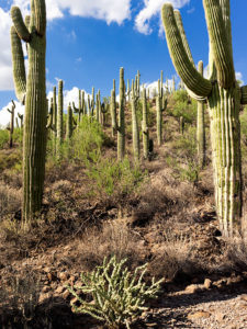
When I was roaming around Black Canyon City a couple of weeks ago, I was on a street with homes along the right side and open land on the other. On the hillside was a dense stand of saguaro growing, and I knew I wanted to capture their image, but the field had a barbed wire fence. As I drove further down the street, I found an open spot. A gravel road led onto the property, so I parked the truck and got out for a closer look.
Saguaro Grove – these giant cacti grow exceptionally well on south-facing, well-drained slopes.
I’m usually cautious about trespassing, so I always look for Keep Out signs. After all, this is Arizona, and I’m allergic to bullets. I saw no postings nearby, but a sign was down the road. It read, “Agua Fria National Monument.” I thought, “There’s a national monument? Here, this close to Phoenix? Why don’t I know about this?” All the open areas from Black Canyon City to Cordes Lakes and east of Interstate 17 were given monument status in 2000 because the Agua Fria River is a treasure of ancient dwellings, petroglyphs, and artifacts. There are no freeway signs, visitor centers, or entrance fees. There is a hiking trail that runs its length, and you can walk, bike, or ride horseback. Bloody Basin Road cuts through the monument; from it, you can access a couple of rugged jeep trails. So, I’ve already mentally filed it away as a future project.
Meanwhile, back at Black Canyon City …
Saguaro grows exceptionally well on well-drained south-facing slopes, so when you see a grove like this, you can tell the compass direction—like moss on the north side of trees. The overhead clouds are remnants of Hurricane Rosa, which dumped enough rain to plump up these giant cacti. They look like my uncle making his way to the couch after Thanksgiving dinner. I could have titled the image with a snarky name, but I didn’t. It’s merely titled Saguaro Grove.
You can see a larger version of Saguaro Grove on its Web Page by clicking here. I hope you enjoy viewing this week’s post and return next week when we show another featured image from Black Canyon City.
Sedona is the most romantic town in Arizona. Don’t believe me? Just watch the Social Sound Off question on the evening news. Each evening, they ask a trivia question about Arizona. The news people get lists from internet sites or magazines about the most popular places for something or another. If the question is about tourism or travel, the answer is either the Grand Canyon or Sedona. The romance question was a recent topic and—you guessed it—Sedona was the answer. For more evidence linking the Red Rock Country to lovers, try booking a hotel room in Sedona for Valentine’s Day. The closest room you’re likely to find is in Eloy.
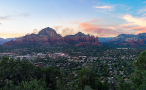
Capitol Butte – a tribe of millionaire-Bedouins have camped in their shabby-chic tents for the night among the red rocks of Sedona.
It’s been over a decade since I last visited Sedona and all of the changes shocked me. Gone is the quiet dusty little creek-side town nestled in Oak Creek Canyon. Back then, there were the usual galleries, jewelry, and souvenir stores in the village, but now it looks like Scottsdale or Newport Beach. The single traffic light has been replaced with dozens of traffic circles. With its limited space and water supply, Sedona has always been the place we loved to death and surely it’s now ready for hospice care.
As a photographer, I’ve been frustrated when shooting there. When you’re trying to get a shot that tells the town’s story, you’re thinking about red rocks, Oak Creek, and the old sycamore trees. You can get that shot at Red Rock Crossing State Park and virtually every photographer has it in his or her portfolio. On this visit, I wanted something different to photograph, so I did a bit of exploring. I hiked a short trail in Boynton Canyon and I ended my day on top of Airport Mesa.
I hung around after sunset until the crowd left—there’s a dedicated parking lot for this viewpoint and people pay three-bucks a car, who knew? I wanted the town dark but have Capitol Butte lit with the soft residual light in the western sky, so I waited until the town lights began to come on.
I believe that I got a different interpretation of this familiar view. I called this image Capitol Butte after the red-rock feature towering over the village. It shows how packed the dwellings are between the rock formations that draw so many people from around the world. I like the contrast of the orderly north-south-east-west streets within a so-called nature setting. When I look at this image, I see a tribe of millionaire-Bedouins camped for the night around the waterhole.
You can see a larger version of Capitol Butte on its Web Page by clicking here. I hope you enjoy viewing this week’s post and come back next week when we’ll show more from Sedona.
When exploring Utah’s State Route 12, you really must take time for a side trip to Utah’s Kodachrome Basin State Park—20 miles east of the Bryce Canyon entrance road. Kodachrome Road runs among the cattle pastures from Cannonville to where the pavement ends and the park entrance. There is a small entry fee which you pay at the visitor’s center. If you’re camping, the park’s sites are coveted and the restrooms have flush toilets, hot and cold water, and they’re heated in winter.
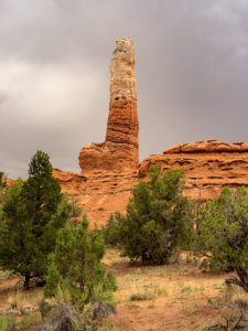
Kodachrome Pipe – Sand pipes are unique to Kodachrome Basin State Park and there are over sixty of them to photograph. All you have to do is find them all.
I’ve written about Kodachrome Basin in my newsletters before because it’s a favorite destination of ours. Located on the valley floor below Bryce Canyon, the elevation is three-thousand feet lower, so in winter it doesn’t have a bitter cold you’ll find back up on the hill. But it also means that summers are warmer and the temperature can crack the century mark.
Surrounding the park are tri-colored cliffs—red, white, and gray—the same colors that make up the middle three stairs of the Escalante Grand Staircase. Unique to Kodachrome Basin is its sand pipes. It’s thought that millions of years ago, this area was like Yellowstone with geysers and hot springs and as the basin sank into a shallow sea it was covered with layers of sand. The geyser’s immense pressure forced fractures in the hardening sandstone and drilled vents. Then, as the plateau rose, rivers cut into the soft sandstone leaving the hard stone pipes behind. There are over sixty pipes in the park for you to find and photograph (hmm, sounds like a book idea). The one in this month’s featured image is on a shelf overlooking the campground like a trophy on display.
Our Kodachrome visit on this trip was by accident. Each day, afternoon thunderstorms kept us off the dirt roads we’d planned to explore. Because the park roads are paved, we changed plans and wasted some electrons photographing Kodachrome Basin in the rain. My first observation is that the colors are duller when they’re wet. My second was that the trails were muddy and the washes were running so we stayed near the roads. I’ve photographed this pipe before but wasn’t happy with the result. This time, I think I have an interesting shot for you. I call this image Kodachrome Pipe, but I may have to begin numbering them in the future. Because it was so overcast, I wasn’t aware that I was shooting directly at the sun—the bright area in the photograph’s sky. While I processed the image, I tried forcing the clouds to be darker, and when I did, the sun’s disk began to show including a rainbow ring around it. The results didn’t look natural, so I dialed it back to this version.
You can see a larger version of Kodachrome Pipe on its Web Page by clicking here. I hope you enjoy viewing this week’s post and come back next week—a new month—when we’ll start a new series from a different place.