Out Buildings Picture of the Week

Any discussion about Black Canyon City wouldn’t be complete without mentioning Rock Springs, so I saved that for last this month. It’s hard for me to know where to begin. If you say that name, most Phoenicians will think about the pie restaurant. It’s understandable, it’s been open for a century now, and every time we drive by and think about stopping, we don’t because it’s packed. Like Yogi Berra said,” Nobody goes there anymore, because it’s too crowded.” As for lasting 100 years, I’d like to extend my congratulations, but I don’t want to talk about pies, I want to discuss its history.

Out Buildings
Out Buildings – A pair of tin roofs on storage sheds behind the Rock Springs Cafe.

Before cars, trains or airplanes—when I was a child—travelers stopped at Rock Springs because it was a reliable source of good water. People came here for centuries before Caucasians lived in Arizona. On your next visit, take the time to stroll around the grounds and look for the Waterfall signs. Outback, you’ll see water drizzling over polished and worn boulders—that’s Rock Springs. The restaurant has a couple of tables out there so you can enjoy a waterside cocktail. I imagine that the flow over the falls is pretty good at times, but when it’s dry, it’s more like forgetting to turn off your garden hose.

The water is the reason that Ben Warner opened a tent-like store, and—in 1918—built a hotel on this site. In case you didn’t notice,  I love these historical buildings. Fortunately, the café has a Web Page that speaks of its history and shows an old photo of the block building—with an A-1 Beer sign hanging from the portico. I really wanted to capture an image of that hotel and talk about some of its famous guests; like Jean Harlow, Tom Mix, and Wyatt Earp. I couldn’t. Decades of hastily planned expansions have camouflaged the original building. Only hints of the original hotel sick out here and there. After circling the restaurant as the sun rose, I gave up and shot other subjects.

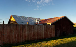
On one of my laps, I saw this interesting pattern of weathered tin roofs on a couple of storage sheds behind the Rock Creek Café. It’s as if they knew that I would be shooting this because they built a simple plank fence that masks the clutter and adds a perspective line to the scene. When I took this shot, I honestly didn’t pay attention to the clouds, but let’s not tell anyone. I’ll claim that I planned it. I call this week’s image: Out Buildings.

You can see a larger version of Out Buildings on its Web Page by clicking here. I hope you enjoy viewing this week’s post and come back next week when we begin a new monthly series from a different place in Yavapai County.

Until next time — jw

Saguaro Grove Picture of the Week

When I was roaming around Black Canyon City a couple of weeks ago, I was on a street with homes along the right side and open land on the other. On the hillside was a dense stand of saguaro growing, and I knew I wanted to capture their image, but the field had a barbed wire fence. As I drove further down the street, I found an open spot. A gravel road led onto the property, so I parked the truck and got out for a closer look.

Saguaro Grove
Saguaro Grove – these giant cacti grow exceptionally well on south-facing, well-drained slopes.

I’m usually cautious about trespassing, so I always look for Keep Out signs. After all, this is Arizona, and I’m allergic to bullets. I saw no postings nearby, but a sign was down the road. It read, “Agua Fria National Monument.” I thought, “There’s a national monument? Here, this close to Phoenix? Why don’t I know about this?” All the open areas from Black Canyon City to Cordes Lakes and east of Interstate 17 were given monument status in 2000 because the Agua Fria River is a treasure of ancient dwellings, petroglyphs, and artifacts. There are no freeway signs, visitor centers, or entrance fees. There is a hiking trail that runs its length, and you can walk, bike, or ride horseback. Bloody Basin Road cuts through the monument; from it, you can access a couple of rugged jeep trails. So, I’ve already mentally filed it away as a future project.

Meanwhile, back at Black Canyon City …

Saguaro grows exceptionally well on well-drained south-facing slopes, so when you see a grove like this, you can tell the compass direction—like moss on the north side of trees. The overhead clouds are remnants of Hurricane Rosa, which dumped enough rain to plump up these giant cacti. They look like my uncle making his way to the couch after Thanksgiving dinner. I could have titled the image with a snarky name, but I didn’t. It’s merely titled Saguaro Grove.

You can see a larger version of Saguaro Grove on its Web Page by clicking here. I hope you enjoy viewing this week’s post and return next week when we show another featured image from Black Canyon City.

Until next time — jw

Perry Mesa Needle Picture of the Week

Perry Mesa Needle
Perry Mesa Needle – This needle is at the edge of Perry Mesa above Black Canyon City. It’s new to me because it’s hidden from the freeway.

Phoenix only has two interstates that will get you the hell out of Dodge; Interstate 10 which either takes you west to California or east to everywhere else, and Interstate 17 going north. Driving I-10 in either direction always seems like a dreary, endless drive through the desert, while I associate I-17 with good times, like playing in the snow or—during summer—just escaping the heat. I think it’s because of all the different climate zones it goes through, like the desert, grasslands, riparian, and alpine forests.

The first change that you come to when heading north is the grade at Black Canyon City. It’s an abrupt transition from the Sonoran Desert to riparian grassland—saguaros are at the bottom, and they’re not at the top. It freezes more often at higher elevations, and the giant cacti can’t tolerate it. Black Canyon City is distinguished by being the northern edge of the Sonoran Desert; I know that because it says so on their welcome sign.

Most Phoenicians consider Black Canyon City a suburb populated with free-spirited residents. It’s the bottleneck on the highway where heavily ladened trucks insist on passing one another up the steep grade, or traffic is backed up to Prescott because a crash closed the freeway and there’s no other way around. During heavy rain, the community makes the news because the Agua Fria River floods and people get trapped in their homes or cars. If you do stop in town, it’s to get a slice of pie at its famous restaurant. I wouldn’t be surprised if most Phoenicians didn’t know Black Canyon was in a different county—Yavapai. I know that I didn’t, and that’s why I chose Black Canyon City as my place to look for October’s art.

I saw the subject of this week’s photo as I was driving around town. I-17 divides Black Canyon City in two. The business district is on the freeway’s west side while on the east is mostly residential and a few light industries. The needle can be seen on the east side but not from the interstate. That’s why I didn’t know it was there. It’s like a smaller version of Weaver’s Needle in the Superstitions, but as much as I searched, I couldn’t find its name. There was nothing on my topographic maps, highway maps, the Gazetteer or the city’s website. I saw this neat YouTube drone video, but it doesn’t list a name either. It’s on the southwest corner of Perry Mesa (sounds like an excellent name for a lawyer, doesn’t it?) where Squaw Creek runs into the Agua Fria River, so I used that moniker for the photo’s name—Perry Mesa Needle.

In this image, I like the way the low clouds and their shadow frame the subject. The grove of saguaro midway up adds scale to the outcrop. Finally, the recent rains cleared the air and gave me a deep blue sky making the puffy white clouds seem to pop in 3D. As was the case with the Jerome Hollyhocks a couple of months ago, if you know this needle’s name, please email me.

You can see a larger version of Perry Mesa Needle on its Web Page by clicking here. I hope you enjoy viewing this week’s post and come back next week when we’ll feature more from Black Canyon City.

Until next time — jw

Climbers Picture of the Week

This week’s featured image was shot in Boynton Canyon on Sedona’s west side, north of State Route 89A. It’s the site of The Enchantment Resort—a very high-end destination requiring deep pockets to stay there. There are several trails in the canyon that meander among the cliffs and buttes, and that’s exactly what I was searching for. In the parking lot, the map said that I had a choice of three routes: one that went to a dead-end up the canyon, a second longer trail over Dead Man’s Pass, and finally a short hike to a canyon overlook. I’m all for short and I’m adverse to dead men, so I set off for the overlook.

The trail is fishhook-shaped as it skirts the south side of an outcrop then turns 180° and ascends into a saddle, wedged between the outcrop and a larger butte. It’s only a quarter-mile long, but the rise got tricky in a couple of sections. It’s good that it was well-marked with white paint splotches. The climb doesn’t seem much until you reach the saddle and turn around and see the valley floor a couple hundred feet below. To the west is a great view of the resort nestled among the red-rock cliffs.

As I clambered up the hill, I stopped a couple of times to rest and clear the heart beating in my ears. When I could hear again, there were voices, but I couldn’t see anyone on the trail above or behind me. It wasn’t until I reached the saddle that I saw a pair of climbers—a woman and a man tethered together with a rope—as they were nearing the butte’s summit. I assumed that she was leading as she was higher and coaching his assent.  “Cool,” I thought.

Once I reached the saddle, I set up my tripod and camera and began shooting all the compass points, and savored the water I remembered to bring. After I completed my long-shots, I started a series of close-ups with the camera hand-held. I could tell from their voices that my climbers had reached the top and were taking in the view.

Climbers
Climbers-A pair of rock-climbers celebrates success atop a Sedona Butte.

I thought about photographing them while they were enjoying their success, so I yelled up to them, “Hey! Can I get a shot?”

They were so polite. They hunkered down out of sight. “No,” I shouted again, “I want to shoot you on top.” When they stood up, I pantomimed celebration by raising my hands in the air. They followed my instructions and even began whooping. I fired off a couple of frames and shouted “Thanks” to them and then began to make my way back down to the truck.

I like the way the shot Climbers turned out even though they don’t take up a lot of frame space. As an Alaska guide once instructed us, “Humans are easy to spot. They’re the only thing standing erect.” In the image, I wanted to show their difficult conquest so I didn’t bother with a long lens. I also like the way the red sandstone contrasts against the dark blue sky and streaky cloud so I included more of it in the composition.

You can see a larger version of Climbers on its Web Page by clicking here. I hope you enjoy viewing this week’s post and come back next week when we’ll show another featured image from Sedona.

Until next time — jw

Timberline Picture of the Week

Timberline
Timberline – The subjects of this image suggest that it is on a scale larger than it really is.

The wind was warmer than I expected at this altitude. Blowing on my back, it seemed to help push me along the John Muir Trail in California’s High Sierra’s. The Mt. Whitney Trail was only a half mile further when I stopped to snap this photo of massive granite formations along the tree line.

I just made all of that up. My chances of hiking those famous trails have long vanished, but this week’s photo has a sense of scale that could work with a fictitious story like that. I took this photo I call Timberline at the Granite Dells along with the others featured this month. It’s the angle that fools the eye so that you think you’re looking at a craggy mountaintop. The trees also play tricks with your sense of scale. They’re actually shrub-size like they were scale models of ones that are much taller—bonsai versions if you will, and the sheer drop in the lower left isn’t the hundreds of feet that it seems. It’s only a dozen feet over your head as you hike the Flume Trail to the park’s northern boundary.

The reason I included Timberline in this month’s set is that it distills the Granite Dells into three simple elements; massive rocks, trees eking a living in hostile conditions, and the changing sky over them. The photo speaks of weight—or mass—and it shows a time contrast of a changing sky and momentary life against the permanence of the weathered granite. The sky changes hourly while the trees will be different in a century, but the granite will survive the next millennia unaltered.

You can see a larger version of Timberline on its Web Page by clicking here. I hope you enjoy viewing this week’s post and come back next week when we start a new set of images from a new location.

Until next time — jw

Lime Lichen Picture of the Week

Lime Lichen
Lime Lichen – The main lichen growing in the Granite Dells is either orange or a pale green. Every so often, you’ll find a bright green patch such as this.

In last week’s post, I wrote how the Granite Dells boulders weren’t just bare rock, but they’re covered with living organisms which gives them color and texture. As you hike along the trails and take a closer look, you’ll find lichen, moss, fungi, and things that only a botanist could name growing there. Although they resemble a plant, lichen is a relitive of algae. They don’t put down roots, but instead, they get water and nutrients from the air. Lichen has a surprisingly long lifespan, but they don’t handle pollution well. When we were landscaping our Goodyear home, Anne and I specifically picked out some boulders that had a green specimen growing on them. Within six months, all the growth vanished.

There are two predominate colors of lichen in the Dells, an orange and another that is light green—seafoam if you will. Occasionally there’s a patch of a bright green specimen that catches the eye, and that’s how I happened upon this shot. The green was a small part on the larger rock surface, so to make it stand out, I moved in close enough and made it the subject of this photo. I like the way the bright green dominates the other muted colors. In all, I count four species growing in this shot. Because there’s not a structure in it, the abstract image is about color and texture. I call it Lime Lichen.

You can see a larger version of Lime Lichen on its Web Page by clicking here. I hope you enjoy viewing this week’s post and come back next week and see more from the Granite Dells.

Until next time — jw

Orange Boulders Picture of the Week

Orange Boulders
Orange Boulders – Lichen-covered granite boulders have weathered and fell off their tight-fitting stack.

A this week’s featured image shows, the trails of Granite Dells City Park provide diversity you wouldn’t expect to find in a massive formation of slow-cooled lava. This week’s featured image shows a small example of that. It comes from one of the Flume Trail’s spurs. Instead of walking around a ridge, this option climbed over it, before it descends and rejoins the main path on the other side. I’d call it a shortcut, but since it added a climb, it didn’t save any time.

On the ridge, the view opens, and since the granite pile tops were exposed to weathering longer than below, so more of the car-sized boulders lay scattered on the ground. If you’ve only driven by The Dells, you’d get the idea that the rocks are nothing but dirt. As you can see in this image, they’re actually covered with lichen of various colors. Here an orange species grows next to a green varietal. Up close, they give the rocks a velvety texture.

I stopped along the trail to capture this image because this tumbled pile of rocks stood apart from assembled puzzle stacks surrounding them. The distinct orange color caught my attention too. There are other colors that you’ll see as you walk along the trails. We’ll bee seeing some of those in other photos this month. Finally, I included a bit of the trail in this image to add a leading line and some perspective to the image.

You can see a larger version of Orange Boulders on its Web Page by clicking here. I hope you enjoy viewing my newest entry and come back next week when we show another photo from Granite Dells.

Until next time — jw