Swilling Cabin Window Picture of the Week

This week’s story has all the ingredients of a great Hollywood western movie: plantations, young love, war, drugs and alcohol, heartbreak, gold, bright futures, despair, stage robbery, friendship, false accusations, and tragic death. I don’t know how I can tell it all in 500 words and still explain my weekly photograph by the third paragraph. I’ve found several books and articles about Jack Swilling, but there haven’t been any films. That’s a shame because I can visualize told in the fashion of the Steve McQueen movie Tom Horn.

Swilling Cabin Window
Swilling Cabin Window – Jack and Trinidad’s cabin ruins in Black Canyon City are on private property, and its caring owners are its only protection.

Every school kid in Phoenix knows how Jack Swilling—or one of his friends and crew, Phillip Duppa—tossed out the mythical bird’s name for the small town they were developing. For the rest of you, Swilling filed a land claim around present-day 32nd Street and Van Buren Road. He wanted to grow hay to sell to the cavalry at Fort McDowell, so he copied the Hohokam method of using Salt River water for the fields by digging new canals to his property. The visionary Swilling (I suggest casting a 20-year-old Jeff Bridges) played an essential role in the layout and alignment of the new town. A couple of years later he lost interest when the council—or whoever decided those things back then—moved downtown three miles west to its present site. Jack threw his hand up in disgust and he and his wife, Trinidad (my casting idea would be a 17-year-old Natalie Wood), moved to Gillett—a mining ghost town three miles south of Black Canyon City.

In Gillett, they built a cabin along the stage route and provided travelers and horses food, water, and rest. It helped to supplement his paultry mining income. His health was failing from old head and bullet wounds he got as a younger man. He took morphine and drank whiskey to counter the constant pain, but now the drinking got worse. When he got word that Colonel Jacob Snively—his old Indian war buddy—was killed near Wickenburg by Apaches, Trinidad encouraged him to retrieve the body and give Jacob a proper burial. Jack enlisted the help of a couple of neighbors and rode out to recover his friend. During that same three-day period, a stagecoach was robbed—also in Wickenburg—and the robbers murdered everyone on board. After Jack returned and buried his friend, he was at the bar when he heard about the stagecoach massacre. Jack cracked a joke about how robbing the stage is the only way to make big money these days, and the vague description of the robbers could include his retrieval party. They were arrested on the spot and shipped off to Prescott for trial. Since the Feds had charged him too, the territorial government dropped their complaints to save money. The marshalls transferred Swilling to the Yuma prison where his health took a turn for the worst, and he died before his trial. Shortly after his death, the law identified and caught the real robbers. Jack was already buried in the Yuma Prison cemetery before they notified Trinidad of his death.

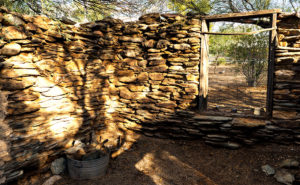
When I decided that October’s subject would be Black Canyon City, I did my research, and there, I discovered the cabin ruins were in town. I wanted to photograph them, but they’re not on a map. That’s because they’re on private property and not open to the public. I stopped and talked to the tourist info people, and they gave me directions to the house, and when I drove up to the residence, the owner came out and chatted with me. When her parents built her home, they bought adjoining lots so that the stacked-stone cabin could remain intact. Black Canyon City doesn’t protect historic sites as other cities do, so they took that task upon themselves. She gave me permission to roam the property and to photograph the cabin with two caveats: don’t lean on the walls—they’re fragile and will quickly crumble, and don’t take any of the artifacts she has on display. A very reasonable request, I’d say.

Of the shots I took, I liked this variation best because of the window and the light filtering through the mesquite trees. Jack’s one-room cabin may not seem like the palace that the Father of Phoenix (and Mother) should have lived in, but just examining the rock-work made my sciatica nerve go off. It’s on a quiet cul-de-sac surrounded by modern homes near the Agua Fria River. I stood for a while and listened to the breeze blowing through the tree canopy, and I could see how it might have been to live there a century and a half ago.

You can see a larger version of Swilling Cabin Window on its Web Page by clicking here. I hope you enjoy viewing this week’s post and come back next week when we’ll show another featured image from Black Canyon City. “Oh!” you say. “But Grandpa, what about the rest of the story—where are the parts about the plantation, the Mexican-American War, the Confederate Lieutenant, Peeples Valley, Rich Hill, et al.” Well, you’ll have to wait for the movie or pick up a book.

Until next time — jw

Saguaro Grove Picture of the Week

When I was roaming around Black Canyon City a couple of weeks ago, I was on a street with homes along the right side and open land on the other. On the hillside was a dense stand of saguaro growing, and I knew I wanted to capture their image, but the field had a barbed wire fence. As I drove further down the street, I found an open spot. A gravel road led onto the property, so I parked the truck and got out for a closer look.

Saguaro Grove
Saguaro Grove – these giant cacti grow exceptionally well on south-facing, well-drained slopes.

I’m usually cautious about trespassing, so I always look for Keep Out signs. After all, this is Arizona, and I’m allergic to bullets. I saw no postings nearby, but a sign was down the road. It read, “Agua Fria National Monument.” I thought, “There’s a national monument? Here, this close to Phoenix? Why don’t I know about this?” All the open areas from Black Canyon City to Cordes Lakes and east of Interstate 17 were given monument status in 2000 because the Agua Fria River is a treasure of ancient dwellings, petroglyphs, and artifacts. There are no freeway signs, visitor centers, or entrance fees. There is a hiking trail that runs its length, and you can walk, bike, or ride horseback. Bloody Basin Road cuts through the monument; from it, you can access a couple of rugged jeep trails. So, I’ve already mentally filed it away as a future project.

Meanwhile, back at Black Canyon City …

Saguaro grows exceptionally well on well-drained south-facing slopes, so when you see a grove like this, you can tell the compass direction—like moss on the north side of trees. The overhead clouds are remnants of Hurricane Rosa, which dumped enough rain to plump up these giant cacti. They look like my uncle making his way to the couch after Thanksgiving dinner. I could have titled the image with a snarky name, but I didn’t. It’s merely titled Saguaro Grove.

You can see a larger version of Saguaro Grove on its Web Page by clicking here. I hope you enjoy viewing this week’s post and return next week when we show another featured image from Black Canyon City.

Until next time — jw

Perry Mesa Needle Picture of the Week

Perry Mesa Needle
Perry Mesa Needle – This needle is at the edge of Perry Mesa above Black Canyon City. It’s new to me because it’s hidden from the freeway.

Phoenix only has two interstates that will get you the hell out of Dodge; Interstate 10 which either takes you west to California or east to everywhere else, and Interstate 17 going north. Driving I-10 in either direction always seems like a dreary, endless drive through the desert, while I associate I-17 with good times, like playing in the snow or—during summer—just escaping the heat. I think it’s because of all the different climate zones it goes through, like the desert, grasslands, riparian, and alpine forests.

The first change that you come to when heading north is the grade at Black Canyon City. It’s an abrupt transition from the Sonoran Desert to riparian grassland—saguaros are at the bottom, and they’re not at the top. It freezes more often at higher elevations, and the giant cacti can’t tolerate it. Black Canyon City is distinguished by being the northern edge of the Sonoran Desert; I know that because it says so on their welcome sign.

Most Phoenicians consider Black Canyon City a suburb populated with free-spirited residents. It’s the bottleneck on the highway where heavily ladened trucks insist on passing one another up the steep grade, or traffic is backed up to Prescott because a crash closed the freeway and there’s no other way around. During heavy rain, the community makes the news because the Agua Fria River floods and people get trapped in their homes or cars. If you do stop in town, it’s to get a slice of pie at its famous restaurant. I wouldn’t be surprised if most Phoenicians didn’t know Black Canyon was in a different county—Yavapai. I know that I didn’t, and that’s why I chose Black Canyon City as my place to look for October’s art.

I saw the subject of this week’s photo as I was driving around town. I-17 divides Black Canyon City in two. The business district is on the freeway’s west side while on the east is mostly residential and a few light industries. The needle can be seen on the east side but not from the interstate. That’s why I didn’t know it was there. It’s like a smaller version of Weaver’s Needle in the Superstitions, but as much as I searched, I couldn’t find its name. There was nothing on my topographic maps, highway maps, the Gazetteer or the city’s website. I saw this neat YouTube drone video, but it doesn’t list a name either. It’s on the southwest corner of Perry Mesa (sounds like an excellent name for a lawyer, doesn’t it?) where Squaw Creek runs into the Agua Fria River, so I used that moniker for the photo’s name—Perry Mesa Needle.

In this image, I like the way the low clouds and their shadow frame the subject. The grove of saguaro midway up adds scale to the outcrop. Finally, the recent rains cleared the air and gave me a deep blue sky making the puffy white clouds seem to pop in 3D. As was the case with the Jerome Hollyhocks a couple of months ago, if you know this needle’s name, please email me.

You can see a larger version of Perry Mesa Needle on its Web Page by clicking here. I hope you enjoy viewing this week’s post and come back next week when we’ll feature more from Black Canyon City.

Until next time — jw

Capitol Butte Picture of the Week

Sedona is the most romantic town in Arizona. Don’t believe me? Just watch the Social Sound Off question on the evening news. Each evening, they ask a trivia question about Arizona. The news people get lists from internet sites or magazines about the most popular places for something or another. If the question is about tourism or travel, the answer is either the Grand Canyon or Sedona. The romance question was a recent topic and—you guessed it—Sedona was the answer. For more evidence linking the Red Rock Country to lovers, try booking a hotel room in Sedona for Valentine’s Day. The closest room you’re likely to find is in Eloy.

Capitol Butte
Capitol Butte – a tribe of millionaire-Bedouins have camped in their shabby-chic tents for the night among the red rocks of Sedona.

It’s been over a decade since I last visited Sedona and all of the changes shocked me. Gone is the quiet dusty little creek-side town nestled in Oak Creek Canyon. Back then, there were the usual galleries, jewelry, and souvenir stores in the village, but now it looks like Scottsdale or Newport Beach. The single traffic light has been replaced with dozens of traffic circles. With its limited space and water supply, Sedona has always been the place we loved to death and surely it’s now ready for hospice care.

As a photographer, I’ve been frustrated when shooting there. When you’re trying to get a shot that tells the town’s story, you’re thinking about red rocks, Oak Creek, and the old sycamore trees. You can get that shot at Red Rock Crossing State Park and virtually every photographer has it in his or her portfolio. On this visit, I wanted something different to photograph, so I did a bit of exploring. I hiked a short trail in Boynton Canyon and I ended my day on top of Airport Mesa.

I hung around after sunset until the crowd left—there’s a dedicated parking lot for this viewpoint and people pay three-bucks a car, who knew? I wanted the town dark but have Capitol Butte lit with the soft residual light in the western sky, so I waited until the town lights began to come on.

I believe that I got a different interpretation of this familiar view. I called this image Capitol Butte after the red-rock feature towering over the village. It shows how packed the dwellings are between the rock formations that draw so many people from around the world. I like the contrast of the orderly north-south-east-west streets within a so-called nature setting. When I look at this image, I see a tribe of millionaire-Bedouins camped for the night around the waterhole.

You can see a larger version of Capitol Butte on its Web Page by clicking here. I hope you enjoy viewing this week’s post and come back next week when we’ll show more from Sedona.

Until next time — jw

Lime Lichen Picture of the Week

Lime Lichen
Lime Lichen – The main lichen growing in the Granite Dells is either orange or a pale green. Every so often, you’ll find a bright green patch such as this.

In last week’s post, I wrote how the Granite Dells boulders weren’t just bare rock, but they’re covered with living organisms which gives them color and texture. As you hike along the trails and take a closer look, you’ll find lichen, moss, fungi, and things that only a botanist could name growing there. Although they resemble a plant, lichen is a relitive of algae. They don’t put down roots, but instead, they get water and nutrients from the air. Lichen has a surprisingly long lifespan, but they don’t handle pollution well. When we were landscaping our Goodyear home, Anne and I specifically picked out some boulders that had a green specimen growing on them. Within six months, all the growth vanished.

There are two predominate colors of lichen in the Dells, an orange and another that is light green—seafoam if you will. Occasionally there’s a patch of a bright green specimen that catches the eye, and that’s how I happened upon this shot. The green was a small part on the larger rock surface, so to make it stand out, I moved in close enough and made it the subject of this photo. I like the way the bright green dominates the other muted colors. In all, I count four species growing in this shot. Because there’s not a structure in it, the abstract image is about color and texture. I call it Lime Lichen.

You can see a larger version of Lime Lichen on its Web Page by clicking here. I hope you enjoy viewing this week’s post and come back next week and see more from the Granite Dells.

Until next time — jw

Orange Boulders Picture of the Week

Orange Boulders
Orange Boulders – Lichen-covered granite boulders have weathered and fell off their tight-fitting stack.

A this week’s featured image shows, the trails of Granite Dells City Park provide diversity you wouldn’t expect to find in a massive formation of slow-cooled lava. This week’s featured image shows a small example of that. It comes from one of the Flume Trail’s spurs. Instead of walking around a ridge, this option climbed over it, before it descends and rejoins the main path on the other side. I’d call it a shortcut, but since it added a climb, it didn’t save any time.

On the ridge, the view opens, and since the granite pile tops were exposed to weathering longer than below, so more of the car-sized boulders lay scattered on the ground. If you’ve only driven by The Dells, you’d get the idea that the rocks are nothing but dirt. As you can see in this image, they’re actually covered with lichen of various colors. Here an orange species grows next to a green varietal. Up close, they give the rocks a velvety texture.

I stopped along the trail to capture this image because this tumbled pile of rocks stood apart from assembled puzzle stacks surrounding them. The distinct orange color caught my attention too. There are other colors that you’ll see as you walk along the trails. We’ll bee seeing some of those in other photos this month. Finally, I included a bit of the trail in this image to add a leading line and some perspective to the image.

You can see a larger version of Orange Boulders on its Web Page by clicking here. I hope you enjoy viewing my newest entry and come back next week when we show another photo from Granite Dells.

Until next time — jw

Dells Scrub Oak Picture of the Week

Dells Scrub Oak
Dells Scrub Oak – The green of a mature scrub oak stands out against the Granite Dells boulders.

This week’s featured image is one that I took while exploring the Flume trail that parallels Granite Creek below the Watson Lake dam. State Route  89 divides Granite Dells Park as it heads north out-of-town, with the Willow Lake complex on the west side and the Watson Lake facilities on the east. Each division has trails that meander through the maze of boulders. The main series of trails around Willow Lake is called the Constellation Trails. I’ve only had a taste of that trail system, but I want to hike there some more. I have hiked a couple of the trails around Watson Lake and I’ve completed the Flume Trail twice.

The trailhead is located along the north park boundary. Access to the parking area is via East Granite Dells Road. The trail is almost a mile long in each direction and has a couple of moderate climbs over a couple of ridges, but a lot of it is flat. At its start, it runs between private properties so you’ll see signs warning you to stay on the path. After the first hill, the trail drops into a wide grassy area where you walk creekside under a growth of Cottonwoods. There is a second ridge you must traverse before the trail returns to Granite Creek and stays there up to the dam. When water is high, excess water rushes out of a flume—sort of an artificial waterfall. The water has been low for several years, so the flume is rarely used.

We visited the Dells on our June Costco run, but I wasn’t ready and made a stupid mistake. We left home early so I could go shooting before the warehouse opened. I wanted to photograph with a low sun for the color and it was around half past eight when we got to the parking area, but the day was going to be hot—even in Prescott. While Anne waited in the shade, I grabbed my camera and a second lens and then headed up the trail without water. It was going to be a hit-and-run shoot lasting an hour, tops. I hiked this trail five years ago without problem when we spent the 4th in Prescott. This time I underestimated the strenuousness of the climb, the morning’s heat, and the extra two-thousand feet of altitude. By the time I stumbled back to the car, I was in such bad shape that I made Anne drive us to breakfast while I downed a quart of water. When we got to Costco, we bought a small backpack that I can carry camera equipment and a couple of bottles of water in. Live and learn, eh?

I came upon this scene at the trail’s beginning. After leaving the parking area and making my way over the first hill, I saw this scrub oak—a rather large and nicely shaped one at that—growing in the rock cracks. The green of its leaves stood out against the tan of the granite boulders towering over it. The wispy clouds made the blue sky interesting, so I included them in my composition.

You can see a larger version of Dells Scrub Oak on its Web Page by clicking here. I hope you enjoy viewing my newest entry and come back next week when we present another photo of the Granite Dells.

Until next time — jw