I’m all alone this week because Queen Anne has gone home to her sister’s because they made Christmas cookies this week, and Anne goes where the sugar is. For me, it’s good news and bad news. The good news is that the bleeding from my ears has stopped since the yelling ceased. The bad news is that I don’t have a copy editor this week, so this will be a short post. I don’t know how to spell all the big words she uses. She’s coming home on Thursday so things will be back to normal then. Pray for me.
Meanwhile back at the mines—or more specifically, San Domingo Wash where Anderson Mill is.
Back in the days when everybody used film—that’s the cellulose stuff you put in cameras to capture images before we used electrons—I was a stingy shooter. Because each frame cost a buck (sheet film was five-times that), I wouldn’t waste my money on something I wasn’t sure was good. Now that electrons are cheap (and the prices keep falling), I’ll snap just about anything that catches my eye. Often that shot turns out to be junk, but one out of a thousand deserves a second look. That’s how this week’s featured image happened.
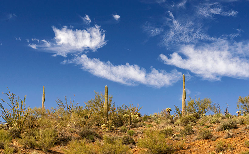
Pair of Threes -Three saguaro along the ridge overlooking the San Domingo Wash where the Anderson Mill is. The three wispy clouds make up the pair.
If you’re the kind of person that lingers on every word that I write, you’ll recall that in my previous posts that the Anderson Mill structure is several stories tall and that the brothers welded it together as needed. In the short time that Fred and I were there, I wanted to poke around the different levels. Now, there are steel-treed stairs, but most of them didn’t have handrails. So I walked the truck paths that snaked up the hillside. It was at one of the switchbacks that I looked up and saw three saguaros along the ridge. Without thinking, I snapped the camera shutter and then dismissed it. When I saw that image on the computer, I knew I could use it because the clouds made the photo. I call this image Pair of Threes.
You can see a larger version of Pair of Threes on its Web Page by clicking here. I hope you enjoy viewing this week’s post and come back next week when we’ll show another featured image from San Domingo Wash.
Until next time —
jw
BTW: Anne’s flight comes in after 11 pm. If you were a good friend, you’d pick her up … and keep her.
There are hundreds—if not thousands—of abandoned towns and mines in Arizona. Most of them don’t have much to offer, because all of the things of interest have been taken away. As I pointed out in last week’s post about Anderson Mill, the good stuff has already been salvaged. In Arizona, there are about ten ghost towns, like Jerome, Bisbee, and Oatman where the residents were able to transform their community into a tourist destination, but the majority of them have returned to nature, and you’re lucky to find a concrete slab.
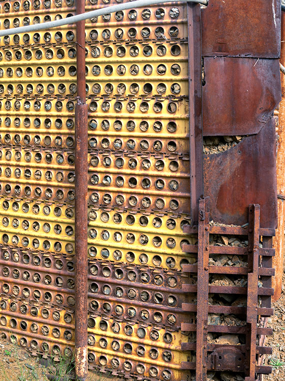
Retaining Wall – A retaining wall at the Anderson Mill made from surplus Army landing pads and steel plate.
Last week’s adventure to Anderson Mills is an example of my point. I would have been delighted if the sheds, trucks and other equipment remained on site. Alas, that’s not the case. At least the main-processing structure was still standing, probably because it was welded together and pirates couldn’t easily strip them. From what was left, I even got an idea of how the Anderson brothers cobbled together the plant with scrounged parts and probably no plans. My dad worked like that. He figured it out in his head and would slap things together. I should ask Fred—who’s a certified nuclear welding inspector—what he thought of the fabrication.
As I was shooting, I looked for strong elements of design; colors, patterns,lines—that sort of thing. As we were ready to make the trip home, I didn’t havemuch time to spend behind the camera. The most color that caught my eye rightaway was a retaining wall, built out of Army landing pads. The mica processingplant is gravity feed and sits maybe 50 feet above the bed of the wash. To makea level base up there, the Andersonsbuilt a reinforced embankment wall out of panels and then back-filled it withrubble.
When I took this picture of the week, I focused on the panels that had alternating yellow color values. I like that against the rusty steel corner plates. However, I didn’t notice the narrow gauge mine-car tracks holding the bottom together. It seems like an expensive piece of scrap metal compared with the other building materials used. I like the abstract feeling of this image, and I call it Retaining Wall.
You can see a larger version of Retaining Wall on its Web Page by clicking here. I hope you enjoy viewing this week’s post and come back next week when we’ll show another featured image from San Domingo Wash.
Once again the page on my calendar has changed, and I need to find a new site in the county to photograph. I spent all last week pouring over my maps that I had spread across the dining room table looking for an exciting candidate. I wanted to avoid the Christmas decorations towns put up during the holidays, so I was resigned to someplace rural. Then—on Monday—during my morning bike ride, I passed the Poteets who were out for a morning stroll. As I passed by, he shouted out an offer to ride in Fred’s fabulous four-wheel flier. The park’s off-road group planned an outing to Anderson Mill. I didn’t know what that was, so when I got home, I looked it up, and behold, it was in Yavapai County—only by a mile, but it still counts, and that meant the trip would kill one stone with two birds. I immediately sent him an email accepting his invitation.
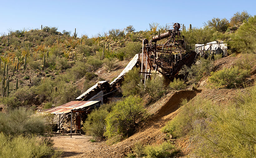
Anderson Mill – A World War II-era mine and mill that produced mica for electrical insulators.
Before I talk about the mill, let me explain the trip. The off-road group is a bunch of friendly people who have all-terrain vehicles (ATVs) or rock-crawling Jeeps, and they go on regular outings to places of interest to drive their toys. It’s the trip and not the destination that’s important; the more circuitous the route, the better. We spent all day driving to a place that’s only a half hour away if you go by the highway into Wickenburg. They drove down the washes and trails where Fred and I got lost a couple of years ago, and they did it on purpose. They relish getting dusty; something they feel is a feature and not an off-road nuisance. The dust was terrible when Fred and I went out alone, but this time we followed a half-dozen other ATVs. When I walked into the house that evening and brushed the dust off, it looked exactly like in this YouTube clip from the new Cohen Brothers Netflix movie The Ballad of Buster Scruggs (Another masterpiece. Try to imagine Gene Autry meets the Twilight Zone).
Meanwhile, back at the mill …
Water Pump Gears – The gears of the Anderson Mill water pump located north of Wickenburg.
Anderson Mill was a homestead claim run by Sid Anderson and his brother (documents don’t show the brother’s name) during the World War II period. They mined and processed mica—a mineral useful for electrical insulation and drywall joint compound among other things. The mine and mill are located in the San Domingo Wash north of Wickenburg and was productive until 1951—when plastics became a cheaper substitute. The mill’s ruins consist of welded panels and stairs topped by a rotating tumbler that—oddly enough—still has the original drive belt. As you would expect, pirates have already salvaged all the working motors and engines.
This week’s featured image is from a pump that pushed water up to the tumbler. The smaller gear drove the large one, which eventually cycled a piston pump. A Hit-and-Miss engine probably powered the whole Rube Goldberg setup. The things that compelled me to take this image are the relationship of the gears, the radial pattern of the spokes, the mass of iron bolted to an I-beam, and the beautiful rust patina. I gave the photograph the simple name of Water Pump Gears.
You can see a larger version of Water Pump Gears on its Web Page by clicking here. I hope you enjoy viewing this week’s post and come back next week when we’ll show another featured image from San Domingo Wash.
Before Interstate 40, before Route 66, and before the Railroad, Seligman was a quiet Havasupai Village where Beale’s Wagon Road crossed the Big Chino Wash, and the reason you stopped there was for water. Back then it was called Prescott Junction because you could hop on a stagecoach to the territorial capital. Not a lot of people traveled that wagon trail because it was rough, dangerous, and in the middle of the God-forsaken desert. All of that changed in 1849 when James Marshall discovered gold in California, and suddenly everybody and his brother wanted a share.
Congress immediately passed a bill to give away ridiculous chunks of land as incentives for railroad upstarts to lay tracks from coast to coast, but the Civil War got in the way. Shortly after peace broke out, the railroads got to work in earnest. In those days, you had to plan for fuel and water stops every 30 miles, and that’s the reason railroads built regularly spaced stops every 30 miles. They renamed the town Seligman for Jesse—one of the big money guys from New York. Being halfway between Flagstaff and the California border, its site was in an excellent spot for crew swaps, and since there was plenty of flat space, the company built a large switching yard here. So, Seligman became a busy stop along the route. The trains don’t stop anymore, in fact, they don’t even tap the horn as they rush by on the quarter-hour.
Seligman’s historic district is within walking distance of the old depot, which—unfortunately—was demolished in 2008. It had a Harvey House—like the one in Winslow—and a reading room. I would have loved to have added them to my collection, but I’m a decade late. The old section of town has several notable buildings: a garage with gas pump island, a few warehouses, a boarding home, and some overnight cabins that the train crews used.
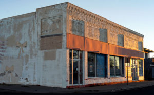
Central Commercial – the Pitts and Washington Central Commercial Department Store on Route 66 in Seligman Arizona. It needs to be restored to red brick, and gold lettering with a green awning.
The building that I kept coming back to was this store. I immediately walked to it, because of the flag mural and yellow ribbons on the side wall. After walking around town, I returned and shot some other angles. When I got out the next morning, there it was again, and I liked how the daybreak lit the front. It shows off every brick and the fascia detail along the top. It even reveals some of the original sign hiding under the whitewash. From the tour guide that I picked up at the barber shop, this is the Pitts & Washington Central Commercial Department Store built-in 1903. The brick was probably red, and the signs were gold—like a Woolworth’s. I believe the whitewash was added later to accommodate new tenants. It’s my picture of the week, and I call it Central Commercial.
I think it would be neat to see it restored and brought back to life as a working museum. I see it stocked with period and retro items for sale. There’s not enough traffic to sustain such a free-standing business, but maybe a display center for an online store could work—sort of an Amazon for antiques. I feel the car culture that the town caters to would patronize a store that carried upscale items like that. On the other hand, maybe it’s too late because that’s my generation’s thing, and we’re fading rapidly.
You can see a larger version of Central Commercial on its Web Page by clicking here. I hope you enjoy viewing this week’s post and come back next week when we’ll show another featured image from a different place in Yavapai County.
When I go to a new town like Seligman, I’m like any other visitor. I take in the bright lights and displays along the main street. After all, that’s the show. The merchants want to attract you into their stores. It makes good business sense. The old maxims counsel you to, “Put your best face (foot) forward,” and “Show your better side.” They can’t make a living if no one comes in. That’s why the storefronts are updated continuously with fresh paint, displays, and signs.
Fire Flag – A retired Seligman fire truck sits along a clapboard store.
But sometimes there’s good stuff out back, and that’s why I walk a new town’s back streets and alleys. They aren’t all spit-polished, and you can see a building’s structure untouched since it was new. If you’re looking for history or art, an alley is more rewarding because merchants ignore it.
That’s how I found the subject for this week’s featured image. It wasn’t behind but along a clapboard-sided store. It has a big faded hand-painted flag and retired fire truck which could be a museum display. The mural alone was a good shot as was the fire engine, but I decided to go for a twofer. The block of purple is a mystery, but it works in the photo. I named this image Fire Flag because it was a short, catchy description of the image.
You can see a larger version of Fire Flag on its Web Page by clicking here. I hope you enjoy viewing this week’s post and come back next week when we’ll show another featured image from Seligman and Route 66.
Well, that didn’t work; it’s not musical and doesn’t even rhyme. I suppose I shouldn’t try to mess with Bobby Troup’s song. I haven’t any musical talent anyway. My grandmother repeatedly told me, “You couldn’t carry a tune in a bushel basket.” The only thing I can play is the radio … while I’m driving, and when I drive across northern Arizona, that 1946 song inevitably pops into my head. Everybody from Bing Crosby, Chuck Berry, to the Cramps, have recorded it, so the tune has legs.
Rusty Bolt-The Rusty Bolt drags bus-loads of tourists into the saloon to try their signature cocktail-a Rusty Bolt. I assume it’s a Rusty Nail in a bigger glass.
The reason that song has become an earworm in my brain is that Queen Anne and I drove two and a half hours to Seligman for this month’s photo shoot and we never left Yavapai County. For fifty miles, Route 66 runs along the northern border of our county—from Yampai to Ash Fork—and Seligman is at the west end of the most extended active section.
I’ve already recalled some of my personal experiences traveling cross-country on US 66, so I don’t want to be your grandpa continually retelling the same stories. But for the next generations, I’ll summarize some of the road’s highlights. Completed in 1926, U.S. Route 66 was one of the first paved highways across the west. It ran from Chicago to Santa Monica and provided an economical alternative to train travel. It was known as the Will Rodgers Highway, Main Street America, and the Mother Road. During the Dust Bowl and Depression era, thousands of migrants traveled west on the highway in search of a new life, a story that John Steinbeck captured in his epic novel Grapes of Wrath. My generation grew up watching Route 66 on a black and white 17” TV. The show’s two male characters—Martin Milner and George Maharis—traveled across the country in a Corvette. Their travels involved but weren’t limited to 66, and no one questioned their sexual orientation back then. The show turned the highway into a symbol of escape and adventure and permanently linked the Corvette to Route 66. (Incidentally, the show’s theme song made Billboard’s top 30 list.) The building of the Interstate System killed Route 66. The freeways went around towns and eliminated stop lights and speed traps. Without Federal money, states abandoned the road and began digging it up.
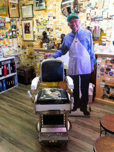
Angie’s Chair – Angie (cardboard cutout) and his wife-Vilma-founded the Route 66 revival movement from his Seligman barber shop and pool hall. I wanted to get my hair cut, but he was home sick with the flu.
In 1978 when Interstate 40 opened and bypassed Seligman, the town’s commerce disappeared, and that put the town’s existence in jeopardy. But the town’s barber administered CPR. Angel Delgadillo met with representatives from other affected communities, and they formed an organization to turn things around. They worked to make the old US 66 a Historic Highway. Within a year, the association successfully lobbied the Arizona State Government to declare the section between Kingman and Seligman a Historic Highway, with parts from Ash Fork to California added later. After that, other states followed our example, and they tagged sections of the remaining road as historic.
The nostalgia caught on, and soon gift shops were selling Route 66 kitsch and memorabilia. Each year, the Historic Route 66 Association organizes a Fun Run. On the first weekend in May over 800 cars gather in Seligman for a car show in the morning before driving en masse to Kingman for the night. The next day, they continue to Needles. Most of the participants are of my generation and are driving cars they wish they had in high school. 2019’s annual run will be the 32nd year.
On our Seligman visit, we saw several businesses competing for customers by displaying memorabilia and vintage cars out front. Of the samples we saw, this one stood out. It’s the Rusty Bolt Saloon and—along with the signs and flags—they added mannequins to their building. I’ll tell you that when you drive by, you think there’s a wild party going on here. I took this shot early in the morning as the sun came up and I liked how the statues stood out in the sun. The other advantage to shooting that early is the lack of tour buses parked along the sidewalk.
You can see a larger version of Rusty Bolt on its Web Page by clicking here. I hope you enjoy viewing this week’s post and come back next week when we return to Seligman and more photos.
Any discussion about Black Canyon City wouldn’t be complete without mentioning Rock Springs, so I saved that for last this month. It’s hard for me to know where to begin. If you say that name, most Phoenicians will think about the pie restaurant. It’s understandable, it’s been open for a century now, and every time we drive by and think about stopping, we don’t because it’s packed. Like Yogi Berra said,” Nobody goes there anymore, because it’s too crowded.” As for lasting 100 years, I’d like to extend my congratulations, but I don’t want to talk about pies, I want to discuss its history.
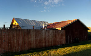
Out Buildings – A pair of tin roofs on storage sheds behind the Rock Springs Cafe.
Before cars, trains or airplanes—when I was a child—travelers stopped at Rock Springs because it was a reliable source of good water. People came here for centuries before Caucasians lived in Arizona. On your next visit, take the time to stroll around the grounds and look for the Waterfall signs. Outback, you’ll see water drizzling over polished and worn boulders—that’s Rock Springs. The restaurant has a couple of tables out there so you can enjoy a waterside cocktail. I imagine that the flow over the falls is pretty good at times, but when it’s dry, it’s more like forgetting to turn off your garden hose.
The water is the reason that Ben Warner opened a tent-like store, and—in 1918—built a hotel on this site. In case you didn’t notice, I love these historical buildings. Fortunately, the café has a Web Page that speaks of its history and shows an old photo of the block building—with an A-1 Beer sign hanging from the portico. I really wanted to capture an image of that hotel and talk about some of its famous guests; like Jean Harlow, Tom Mix, and Wyatt Earp. I couldn’t. Decades of hastily planned expansions have camouflaged the original building. Only hints of the original hotel sick out here and there. After circling the restaurant as the sun rose, I gave up and shot other subjects.
On one of my laps, I saw this interesting pattern of weathered tin roofs on a couple of storage sheds behind the Rock Creek Café. It’s as if they knew that I would be shooting this because they built a simple plank fence that masks the clutter and adds a perspective line to the scene. When I took this shot, I honestly didn’t pay attention to the clouds, but let’s not tell anyone. I’ll claim that I planned it. I call this week’s image: Out Buildings.
You can see a larger version of Out Buildings on its Web Page by clicking here. I hope you enjoy viewing this week’s post and come back next week when we begin a new monthly series from a different place in Yavapai County.