Shadows and Spires: An Afternoon on Big Sandy River Picture of the Week - Wikieup, Arizona

Two sedimentary cliff prominence eroded to form preliminary hoodoos, captured during the golden hour near Big Sandy River, Arizona.
Shadows and Spires: An Afternoon on Big Sandy River – Captured during the golden hour, these eroding cliffs along the Big Sandy River reveal nature’s ceaseless artistry. With preliminary hoodoos and soft evening light, it’s a visual spectacle that evokes the grandeur of Bryce Canyon on a smaller scale.

Have you ever heard the saying, “Necessity is the mother of invention?” Let me tweak that: “Frustration is the father of discovery.” A couple of weeks ago, Queen Anne and I were on a quest to pick up her “new-to-us” car from Henderson, Nevada. Ah, the optimism. The plan was simple: drive up, sign paperwork, and zoom back to Congress. We were convinced we’d be home by 3:00. But reality had other plans: car dealerships—the black holes where time and patience vanish. So, our speedy mission morphed into an all-day ordeal, and instead of a quick casino lunch, we settled for an early Mexican dinner in Kingman.

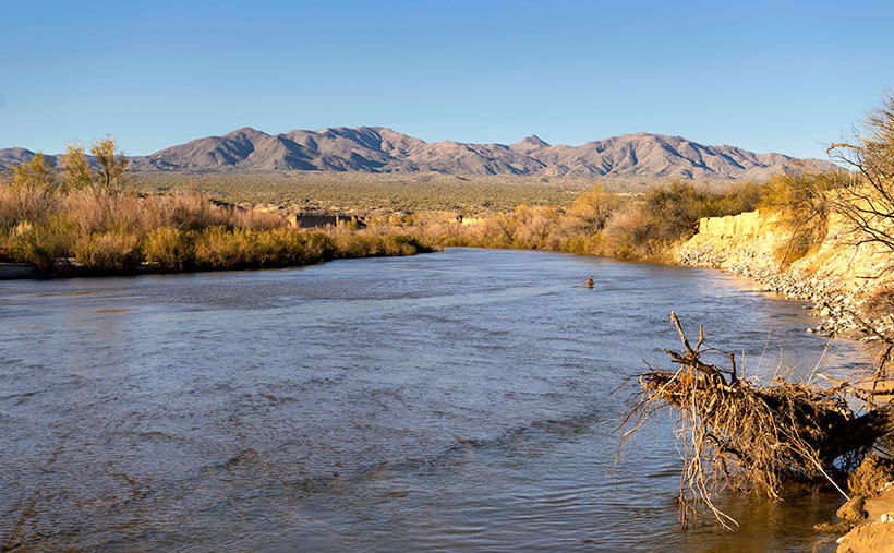
Life’s little curveballs aren’t all bad. The Universe threw us a photographic bone: we were heading back during the golden hour. Of course, I’d left my camera back at the ranch. Insert a string of inventive curses here. Cut to a few days later, and I’m driving that route again, camera in hand and tank full of liquid gold, catching that magical golden hour. Trust me, the encore was worth every cent and expletive.

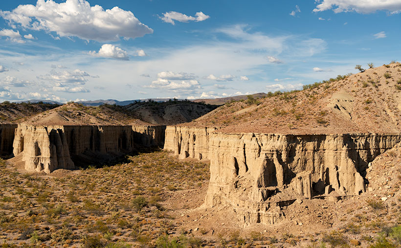
Situated just a stone’s throw south of Wikieup—Arizona’s self-proclaimed ‘Rattlesnake Capital’—we stumble upon an intriguing spectacle: silt cliffs carved by nature’s endless waltz of wind and water. But the real artist here? The Big Sandy River has been doing its chisel work for millennia, crafting an earthen canvas rich with geological stories. The formations boast early signs of hoodoo development, but erosion’s speedy pace keeps them from becoming full-fledged, free-standing wonders. Think of them as Bryce Canyon’s more humble cousins.

Veteran followers might recall a rookie error I made some years back: driving out here in the dead of night to shoot these west-facing cliffs at sunrise. Yeah, not my brightest moment. But this time, bathed in a warm honeyed glow, these cliffs were showing off for my camera. The low sun cast deep shadows, revealing the intricacies of erosion and the potential of fledgling hoodoos—sort of like teenagers eager to bust out on a Friday night.

Thanks for tagging along on this picturesque journey through Arizona’s road to Sin City—remarkable US 93. This highway, often buzzing with travelers darting between Phoenix and Las Vegas, has hidden gems that’ll soon vanish as Interstate 11 takes over. So catch these scenes while you can! For a high-definition experience, check out the larger version on my website (Jim’s) or peruse it on my Fine Art America page (FAA Page). And join us next week, where we’ll explore another sun-kissed snapshot from the drive on US 93 (boy, wouldn’t ‘drive on 95’ have rhymed so much better?).

Until next time
jw

Techniques: The Art of Capturing the Golden Hour

Ah, the golden hour—nature’s very own Instagram filter. This fleeting window right after dawn or before dusk can magically transform even the most drab scene into a masterpiece. Unlike the harsh glare of the midday sun, the golden hour bathes everything in a soft, ethereal light. It’s like Photoshop, but Mother Nature is at the helm.

Wake up early or set an alarm for the evening. Please make sure you’re in position well before the golden hour begins because, let me tell you, this light waits for no one. I’ve made that mistake before, and it was as frustrating as finding a rattlesnake in my boot.

Personal Note: On our Alaska expedition, I discovered that as you venture away from the equator, the golden hour stretches, much like a cat in a sunbeam. That hour of perfect light can become two during summer, and it’s an all-day thing north of the Canadian border in winter. However, it’s over in the blink of an eye in the arid southwest deserts, as if someone flipped off a celestial switch. Timing and location can throw some delicious curveballs into your golden hour captures, so be prepared.

And remember, while nature’s giving you a fantastic light show, your camera still needs some fine-tuning. Since the light is dimmer than mid-day, tripods can help stabilize long exposures, and a wider aperture can draw focus to your main subject. So, pack wisely, set up carefully, and prepare to create magic.

Cholla Bay Picture of the Week

After being stopped by a river that rarely has flowing water, we spent some time along the bank of the Big Sandy, watching the calm, almost clear water flowing on its way to Alamo Lake. Queen Anne broke out a couple of water bottles, and we shared a trail bar while perusing the map to find our options.

This would have been a perfect picnic spot if we had packed a basket. Imagine sitting on a blanket in the middle of 17 Mile Drive, where it disappears beneath a river. We could see a couple of houses nearby, and later, I found out that we were in Greenwood—the site of yet another abandoned mining community. In its heyday, some three hundred souls lived and worked here. The town—named after the abundance of Palo Verde trees—didn’t last long because of its low-quality ore.

We turned around and started our journey home with the day getting late. We dallied along the way, making many stops for photos. Before the road began the ascent up the mountain, I spotted where the Big Sandy River had scoured 30-foot cliffs out of the mud banks. The formation was nearly circular, and you could imagine the raging water churning in a back eddy, a swirling whirlpool flowing against the river’s current. A large grove of Teddy Bear Cholla was growing inside the containment, so I grabbed my camera and hiked in for a shot.

Cholla Bay - The most dangerous cactus will attack you at the slightest provocation.
Cholla Bay – The most dangerous cactus will attack you at the slightest provocation.

I have a love/hate relationship with the cholla cactus. When backlit, it has a soft fuzzy look that makes you want to jump into it like a pile of autumn leaves. It’s also known as Jumping Cholla, but it doesn’t do that. Its outer joints are fragile—hair trigger, if you will—and the tips break off from the main plant with the slightest disturbance. The needles are barbed, so if you get some into your skin, you have to pull them out with pliers—one by one.

Whenever I’m near Cholla, I move slowly and cautiously. I watch the ground for snakes, cow pies, and cholla balls. It’s like walking a tight wire. I don’t look up until I stop walking. So imagine how startled I was in the middle of this field when a wild gray burro popped his head up and snorted. He was just as frightened as I was and quickly galloped off to the far side of the road, but it took all my self-control not to stumble back through the cactus patch. Once the two jackasses safely separated, I regained my composure and took this picture, which I called Cholla Bay.

You can see a larger version of Cholla Bay on its Web Page by clicking here. I hope you enjoy viewing it. Join us next week when we finish our trip to the Poachie Mountains.

Until next time — jw

Big Wet Sandy Picture of the Week

“I know a shortcut.”

How many of you have heard those words and broken into a cold sweat? The road that Queen Anne and I decided to explore this month didn’t start as a shortcut. It was supposed to be a much longer trip, but it got cut short.

I had intended to drive to the north shore of Alamo Lake. There are a couple of exciting mountains I’ve seen from across the water when I last visited. The best road to get there starts in Wikieup. On my maps (including Google), there are two ways to get there. One is twenty miles south of Wikieup, and the other is about five miles south. Both roads go to the little town of Signal. I’m sure you spotted the signs on a drive to Las Vegas.

We decide to take 17 Mile Drive road. It’s the first left after the Nothing Gas Station. It’s a wide well-graded dirt road that climbs over a pass in the Poachie Mountains, then down into a valley where Signal is. The scenery at the pass is amazing—something we’ll get to later—and you can drive the route with your family station wagon. There’s one hitch along the way, and that’s crossing the Big Sandy River at Greenwood. Usually, crossing the river here could be tricky because—well, it’s deep sand, and you might get stuck without four-wheel drive.

Big Wet Sandy - The normally dry Big Sandy River flowing with water from recent rain.
Big Wet Sandy – The normally dry Big Sandy River was flowing with water from recent rain.

That wasn’t the case today. The Big Sandy was a real river and not in an ugly flash flood kind of way. Its waters flowed like it was an old river; clear and quiet. If I didn’t know better, I might have been tempted to pull out my waders and fly rod and make a few casts. It wouldn’t have been my worst day fishing, being the great angler that I am. There was no way to tell how deep the water was. It could have been two feet or a dozen, but it was not tempting enough for the police to cite me under the Stupid Motorist Law.

So, we’ll begin this month’s journey at the end and go backward. As I said, there was enough material to shoot in the mountains to fill a month, so we’ll save Alamo for another month, and we’ll start at the water’s edge.

I took this week’s featured image standing on the river’s bank. If I didn’t know, I would venture a guess that it was a photo of the Colorado River south of Bullhead City, and the mountains were in Nevada. Nope, it’s all Arizona. We’re looking north-east, and the peaks are actually on our side of the Big Sandy. The high point is Burro Peak. Although everything appears calm on this warm winter afternoon, the banks on each side of the water show erosion from raging water at some time. There are more cliff-banks like this—some higher—along the riverside past Wikieup that you can see from Highway 93. I wonder if I’ll ever again see a sight like this.

You can see a larger version of Big Wet Sandy on its Web Page by clicking here. I hope you enjoy viewing it. Join us next week as we start our return over the Poachie Mountains.

Until next time — jw