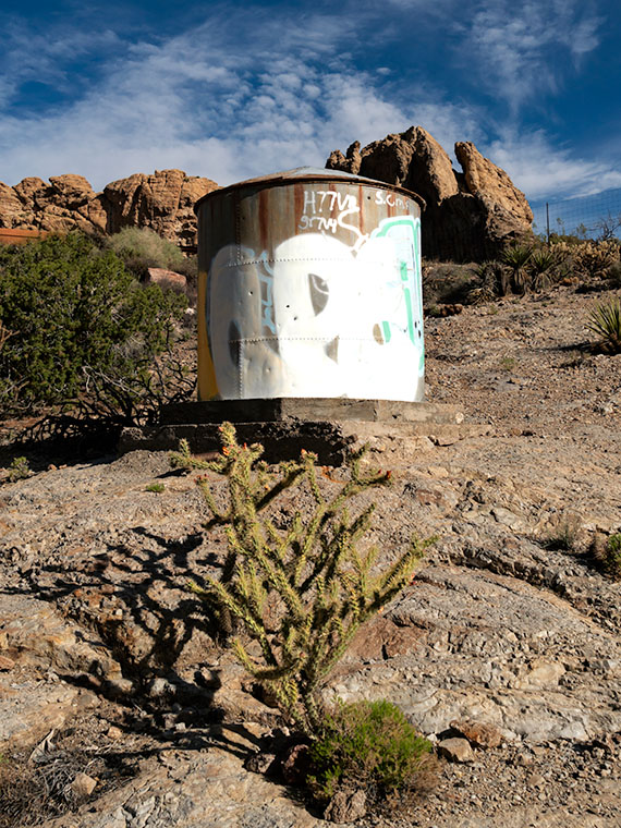
Water Tank—The Richardsons added a water tank to their property to ensure water availability during dry periods.
It’s a miracle! We changed seasons on Tuesday, and we had our first summer rain on Thursday night. Getting rain during summer isn’t unusual, but getting it so soon was. It was nice to finally break our six-month dry spell. It wasn’t a deluge, but enough to tamp down the dust.
Our storm cell came through at 1:00 am, and I listened to the thunder approaching in bed. The weather service says you can tell how far away the strikes are by counting the time between the flash and the thunderclap. “If you count the number of seconds between the flash of lightning and the sound of thunder, and then divide by 5, you’ll get the distance in miles to the lightning: 5 seconds = 1 mile, 15 seconds = 3 miles, 0 seconds = very close.” As I lay in bed, I counted one, two, three …, and then there were a couple of strikes where I didn’t get to finish the one. That’s when I got up.
When I did, Queen Anne was already outside—in the dark—dressed in a T-shirt and flip-flops, moving flower pots around so the rain could water them. I scolded and reminded her about the 3 S’s (snakes, spiders, and scorpions). She seemed oblivious to the blue-white lightning streaking dozens of miles across the black sky above her head. At first, I was concerned that the strikes would start another wildfire because they struck close around us. When the rain started falling, it eased my mind, and I quickly got bored and went back to bed.
According to forecasters, we’re supposed to have an above-average monsoon this season. That’s good because our drought has lasted nearly 20 years. I’m not optimistic that I’ll see a recovery in my lifetime. Climatologists told us of 100-year droughts in the past, and they conjecture that those dry periods may have caused the Anasazi, Sinagua, and other Pueblo tribes to move in search of water.
Water has always been a concern in the desert west. That’s as true today as it was when the Richardsons homesteaded their place in Union Pass. There was a spring near the pass that supported their cattle and orchard. Can you imagine hauling water up 3000′ from the Colorado River? Even with a spring, they need a healthy water reserve to get through the dry months.
As you can see in this week’s photo, Water Tank, they built a large tank on the property for water storage. From this image, I guess the tank dates back to when they made the gas station. The concrete foundation work looks similar to that of the pump island.
I’m sure vandals added the graffiti and bullet holes to the tank’s side after the family moved off the property. They are another example of vandalism that supports my argument that the BLM should set this homestead aside for protection. Otherwise, these ruins won’t be around much longer.
I hope you enjoyed our month at the Richardson Homestead. You can see a larger version of Water Tank on its Website by clicking here. Next week, we begin a new project in a different location. Hopefully, it will be somewhere cool. Please come back then and see what Queen Anne picked for us.
Alright, class, settle down. Get out a sheet of paper and a pen, then put away your backpacks. Today we’re starting with a pop quiz. There is only one question, and you have 15 minutes to answer with 10,000 words—or more. You must cite your sources. Spelling and punctuation will be graded. Are you ready? Your question is, “What do Memphis, Tennessee, and Kingman, Arizona have in common?”
I have talked before about old trading trails morphing into the well-laid-out highway system that we have today. Most of us don’t care how it happened, and we just drive on them. They think that Eisenhower signed a paper in 1956, and the freeways just popped into existence. I think that’s because people younger than me—and that’s pretty much everybody—didn’t experience the change first hand. Our forebearers built most roads over existing paths, and there are reasons someone blazed those original paths. Mark Knopfler describes this phenomenon well in his 1982 song Telegraph Road from the Dire Straits album Love Over Gold.
There have been trading trails across Northern Arizona since the first Pueblo inhabitants. European settlers didn’t use them much because the New Mexico territory was Spanish. Their roads came up from Mexico to towns like Santa Fe and the Old Pueblo at Tucson. Those roads followed the Rio Grande and Santa Cruz Rivers because there was always reliable water. The rest of the desert was a wasteland. What changed that? It was gold.
In 1848, James Marshall discovered gold at Sutter’s Mill in California. In less than two years, California became a state—that’s instantaneous in government time. They needed to move goods and people to the Golden State—and get the gold back to Washington. But, there were no east-west roads, so they put Captain Lorenzo Sitgreaves in charge of a surveying expedition, and he laid out a railroad route around the 35th Parallel.
Then in 1857, the Fed’s paid Edward (Fitzgerald) Beale to build a wagon road from Ft. Smith, Arkansas, to Los Angeles—again along the 35th Parallel (remember, Tucson was still in Mexico). He built his road in a year using camels because they needed less water and food than oxen and horses. By all accounts, it wasn’t much of a road, but Beale bragged that it was the shortest route by 300 miles and “It is the most level: our wagons only double-teaming once in the entire distance, and that at a short hill . . .” His road became the Santa Fe line in 1880, then Route 66 in 1926, and finally Interstate 40 in 1978.
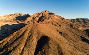
SR 68 through Union Pass – Arizona State Route 68 (on the right) as it enters Union Pass through the Black Mountain Range.
His wagon road wandered a bit from the 35th as it meandered across the desert, but wagon tracks are visible in places on Google Earth. As vehicles became more efficient, each of the subsequent roads shortened its length. Some silly people hike the old road just for giggles. I’m not that ambitious. However, I do know of a place where you’ll be in Ed’s footsteps. Yep, you guessed it. It’s our Union Pass on SR 68. While Sitgreaves went through Oatman, Beale found a more accessible way to Fort Mohave and his river crossing.
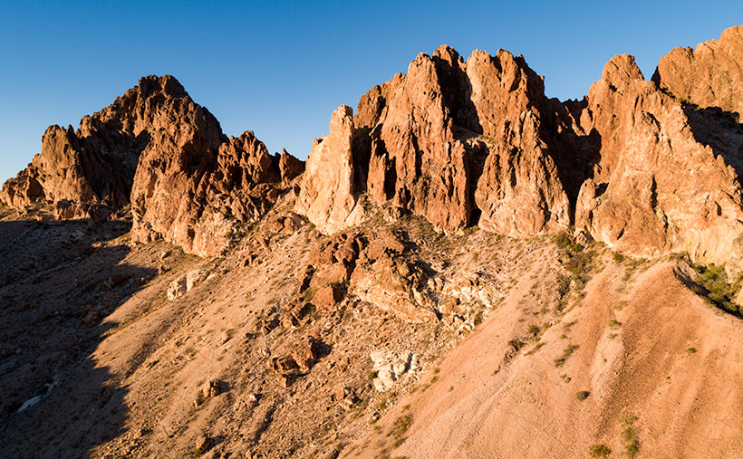
Sunset Wall – Layers of volcanic rock upended vertically in the Black Mountain Range.
I took this week’s picture on the west side of Union Pass, and it shows layers of lava and ash (tuff) that have been turned horizontal by geological forces. As Don Sprinkle commented in another post; “. . . just like the Grand Tetons.” It was sundown as I took this photo, and that’s why the ordinarily dark rock has a beautiful red glow, and that’s why I called it Sunset Wall.
So, back to your quiz; I’m going to let you grade your papers. What did you answer to: What do Memphis, Tennessee, and Kingman have in common? If you said that they are both along Interstate 40, you get 50%, and if you said that they both have a Beale Street, you get another 50%. I must add that there is a difference too. While Kingman knows who they named their street after, according to the Wikipedia entry for Memphis’ Beale Street, nobody remembers who Edward Beale was, which I find amusing. Maybe it’s forgotten because he was a Union Naval officer.
You can see a larger version of Sunset Wall on its Web Page by clicking here. Please come back next when we begin December’s project and new pictures.
Arizona State Route 68 in Mohave County has substantially improved since I first visited Bullhead City decades ago. It was a two-lane back road with faded markings and crumbling tarmac. When it rained, it was impassable because the highway ran through the flooded wash bottoms. These days, it’s a mini-interstate with four lanes and no lights or signs along its 28-mile length. It’s impressive how infrastructure improves when it involves getting people into casinos.
SR 68 also has one of the best views of all the roads I’ve traveled. That vista comes just west of Union Pass in the Black Mountain Range. When you see the Union Pass elevation sign (3570 feet), you can tell it’s coming. There is a wide shoulder here to enable truckers to safety-check their brakes. Immediately after you clear the mountains on either side of the highway, you can see a panoramic view of the Colorado River 3000′ below. Beyond the blue water ribbon, you can see into the Nevada Desert going on forever—especially now that APS has dismantled the coal-fired Mohave Power Station. You don’t have long to enjoy the view because suddenly you’re on the downhill side of the roller coaster, and just for giggles, the highway department put a stoplight at the bottom of the 11 miles of 7% grade.
Thumb Butte – An 800′ tall granite monolith overlooking the Colorado River above Bullhead City.
As you descend into the river valley, a thing that jumps out at you is an 800′ tall granite monolith on the left side of the road. It’s called Thumb Butte on the maps, but many locals call it Finger Rock. It’s visible in both towns—Bullhead City and Laughlin—and from there, it looks like the universal gesture of ill will, the big bird, the highway salute, or whatever your favorite euphemism for the middle finger is. (There is another landmark a couple of miles south officially named Finger Butte—don’t confuse the two.)
I have wanted to photograph the rock before, but my schedule prevented me from stopping. On this year’s trip, I decided to make time. I watched videos, poured over the Topo maps, and found a Jeep Trail that goes right by the tower. So, late afternoon, Archie and I drove the dirt trail and took this week’s photo, which I call Thumb Butte.
I wanted to capture some depth and texture, so I shot the rock from the north side, looking into the Mount Nutt Wilderness Area. I’m happy with how this image captures the rugged terrain of the Black Mountains—if only a tiny sample. Maybe I should regularly go back and work the entire range—from Needles to Hoover Dam. What do you think?
You can see a larger version of Thumb Butte on its Web Page by clicking here. Please return next week when I show another photo from Union Pass and SR 68.
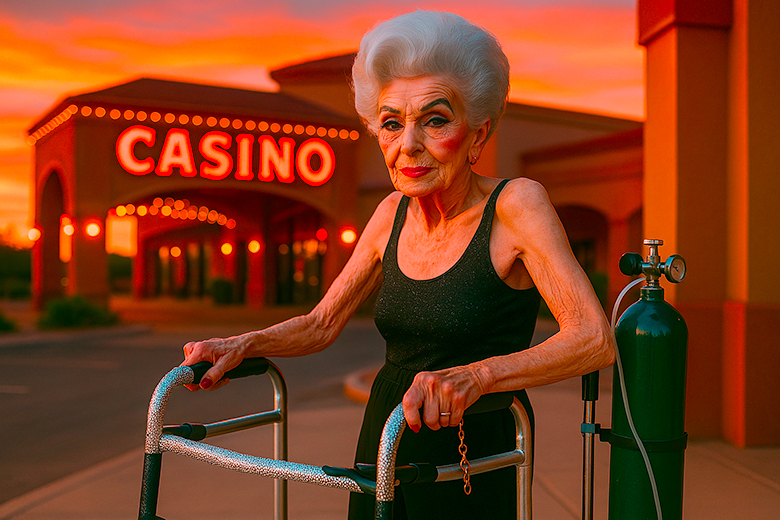
Bold and Beautiful: Natley at the Casino Entrance – Bold and Beautiful: Natley at the Casino Entrance
Queen Anne, my darling wife, flew east last month to join her sisters for a week in New England. Supposedly, it was an Autumn-Leaves tour, but they went to Salem in October during a full moon. I’m no math whiz, but I know what you get when you combine four and ten. That’s right—WITCHES!
I’m a big boy, so I wasn’t about to spend my time alone sulking and drowning my sorrows in a tub of Cherry Garcia—I intended to treat myself to a night on the town—another town—in another state. Laughlin, Nevada, is an easy three-hour drive via Kingman, across Golden Valley, through the Black Mountains, and down to the river. I booked a cheap casino hotel room for Wednesday night and set off, determined to lose some money on a craps table.
The downside of weekdays in Laughlin is that it’s mostly closed. The big weekend crowds are working, so the remaining patrons are retirees like me. Half of the restaurants are dark, and some casinos don’t open the gambling tables. You have to search for a place to eat and find some action, so I ended up at the Riverside Casino. They had a couple of working Blackjack tables and one craps table. I think the staff outnumbered the players when I joined. Two people were on the right of the stickman, so I claimed an open spot on the left.
Trying to get a feel for the player’s moods, I looked at the faces around the table. Because masks were mandatory, it was hard to tell who was doing well. A woman across from me wasn’t even a whole face—only a pair of brown eyes behind jewel-rimed glasses and a silver-blue hairdo peering over the table’s edge. Like my mom, her short hair had enough hairspray to keep it in place between weekly salon visits. She had a few chips on the rail pushed to one side so they wouldn’t block her view of the playing field.
I placed my bet; someone threw the dice twice and lost. Then, we all took a turn bouncing the dice off of the far wall when the silver-haired lady stood up. Until then, I didn’t realize she was sitting. Even when she stood, she wasn’t much taller. She scooped up her remaining chips into a clutch. I thought she was leaving. Instead, she began pushing a walker towards my side of the stickman.
As she maneuvered her tricked-out lavender walker behind the dealer, I saw that she had dressed to party. She had on a very sparkly silver lame top and black spandex pants—which, quite frankly, bagged a bit. Weirdly, as I watched her, I suddenly heard Lenard Cohen singing his tune—Closing Time—in my head:
“…And the place is dead as Heaven on a Saturday night And my very close companion Gets me fumbling gets me laughing She’s a hundred, but she’s wearing Something tight…”
When she got close, she spoke through her mask in a voice from years of smoking Chesterfields, “Hey, big boy. You need a good luck charm.”
“Hi,” I smiled (a useless gesture behind my mask) and introduced myself, “I’m Jim.”
“Nat-ly,” she replied.
“It’s a pleasure to meet you, Natalie.”
“No. I’m from Flatbush. It’s Nat-ly,” she corrected with furrowed eyebrows.
“Sorry. What kind of good luck charm are you talking about?”
She explained, “Well, every high roller knows it’s good luck to have an attractive woman beside him while he rolls the dice. You’re alone, and I’m the best-looking dame in the joint.”
Just glancing around the room was enough to confirm that she was right. “What’s in it for you?”
“Well, you tip me each time I blow on your dice for good luck.”
I was curious, “Do you do this for everyone?”
“Na,” she blushed and went on, “The girls and I spotted you the minute you came through the door.”
“That was because of my dashing good looks and natty fashion sense, I bet.”
“No. You’re the only man in the casino standing upright without a cane. You know how cougars are; we like ’em young and stupid.”
With that, Nat-ly positioned her seat to my right and plopped herself down. On my roll, she blew on my dice for luck. I made my point once, so her luck wasn’t bad. “You’d do even better if I hung off your shoulder,” she offered, “It’s only $20 bucks.”
As she shuffled into position with her walker, I noticed it wasn’t just any old walker—oh no. This thing was tricked out. The wheels sparkled with silver hubcaps, and a small rearview mirror was angled just right so she could check her six. On the front, she had a basket full of essentials: a pack of Chesterfields, a rhinestone coin purse, and what I can only assume was a custom-made cup holder for her drink. This was a woman who came prepared.
Nat-ly caught me eyeballing her ride. “Yeah, pretty sweet, huh? Got it for a steal from that nice boy on Pawn Stars. Ain’t it somethin’?”
I nodded, impressed. “Must turn a few heads.”
“More than you, honey. But don’t worry, you’re cute for an amateur.” She gave me a wink that made me wonder just how deep this rabbit hole of flirtation was about to go.
After she blew on the dice and I made my point, she leaned in close—well, as close as someone who needs a walker can lean—and whispered, “You know, I used to be quite the looker back in my Mustang Ranch days. They called me the queen of the floor.”
I wasn’t sure if she was talking about the casino or…well. Either way, I kept my poker face on.
“I bet you were,” I replied, tiptoeing across a tightrope suspended over a canyon of uncomfortable truths.
Her eyes twinkled mischievously. “You ever been to Mustang Ranch, big boy?”
I coughed and pretended to study the felt of the table like it was the most exciting thing I’d ever seen. “Can’t say I have.”
“Pity,” she sighed, blowing more cigarette-scented luck across my dice. “But you can call me Queen Nat-ly tonight.”
“Right,” I mumbled, “Your Majesty.” I couldn’t help but picture her in some sparkly crown, probably with matching orthopedic shoes.
As I rolled again and somehow avoided crapping out, she started to hum, her raspy voice crackling like the old vinyl records my parents used to have. I strained to listen. Was that Frank Sinatra? No. Wait…Dean Martin? Then I caught the words. “Fly me to the moon…”
Of course, why wouldn’t the woman sitting next to me, flirting and stroking my arm with a cane, be serenading me with a Sinatra classic? This felt like a fever dream, yet I was a willing participant.
Given her stature, I couldn’t imagine how she could reach that high, so my curiosity bettered me. I handed her a couple of chips. She reached down and pulled a cane from the tool rack attached to the walker’s side. Then she raised it, hung the crook over my shoulder, and gently stroked it back and forth. I almost laughed, but she was so adept that it felt alright.
She said, “For $5 more, I’ll play with your ear.” When I turned, she held one of those trash-grabbers for me to examine. I declined, so she slipped it back into its rack spot.
The night passed, and the dice went clockwise around the table twice while we talked. She worked at the Mustang Ranch until the Feds seized it, and she retired. Since the Treasury Department managed the business, she got a federal employee pension. After she quit, she moved south from Reno to enjoy a warmer climate and affordable housing. Now, she spends her free time watching the tanned muscle boys ride jet skis up and down the river.
I managed to hold onto my bankroll an hour and a half before it ran out. As I packed my things, I saw Nat-ly slumped over—asleep. I knew the dealers wouldn’t let her stay at the table alone, and I didn’t want to wake her. So, I pushed her to the nearest quarter slot machine and parked her in front. I reached into my pocket and threw all but one of my quarters into the tray. The last, I stuck in the coin slot. I knew security wouldn’t bother her if a bet were on the table. With that, I left and went to my room. I have pictures to shoot tomorrow so that the day will begin early.
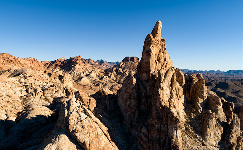
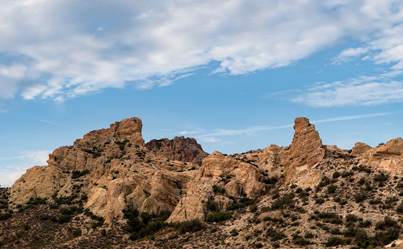
Union Pass – If you’re heading from Kingman to the Colorado River, you’ll find yourself winding through Union Pass, a rugged stretch that feels like something out of a something out of a John Wayne western. It’s a landscape dominated by layers of Tuff—volcanic ash that was once spewed from ancient eruptions like confetti at a Fourth of July parade. Over the millennia, the earth beneath Union Pass has shifted, crunched, and folded like a creased road map in the glove box, the layers into the Black Mountains we see today. The result? Jagged formations of twisted rock that look like they’d been tossed around by a giant who got fed up with a frustrating game of Jenga. These rocks are as old as time and just as stubborn, refusing to wear down despite the elements constantly gnawing at them.
The last time I made it through the Black Mountains of Mohave County was during last year’s trip to Oatman, where I nearly lost my mind watching burros treat the town like it was their buffet. Every time I drive through these mountains, it’s like catching up with an old friend who’s always got a new trick up his sleeve. This time, Union Pass caught my attention—a stretch of road that, depending on the light, either looks like a peaceful desert oasis or the aftermath of a Hollywood disaster flick.
I decided to pull over at the hilltop on my way home, determined to capture the rugged beauty of this desert landscape. I mean, how could I resist? The morning sun played peek-a-boo through thin clouds, casting soft shadows across the rock formations. The kind of light makes photographers drool and desert rats scratch their heads, wondering what the fuss is about.
This week’s featured image comes from my morning scramble at Union Pass. I named it after the location because that’s where I parked the truck, hopped out, and started pacing up and down the highway with my camera like a man on a mission. The morning light, softened by a delicate veil of clouds, created a perfect mix of shadows—.just enough to make the rock layers stand out without giving it the overexposed look of a tacky postcard.
I’m sure these are the same Tuff layers we learned about during our Organ Pipe National Monument visit. Tuff is the aftermath of volcanic eruptions—a thick blanket of ash that hardens over time into solid rock. What makes Union Pass fascinating is how those layers have been cracked and thrust into the sky during the tectonic tantrum—a geological fit of rage—formed the Black Mountains. It’s like nature’s geology lesson, written across the landscape in jagged peaks and crumpled ridges.
If you’re curious about what else I captured at Union Pass, swing by next week. I’ve got another shot that showcases just how wild and beautiful this stretch of the Black Mountains can get. Trust me, you won’t want to miss it!
Wickenburg’s traffic has worsened over the past couple of months—especially during the weekends. People might feel more comfortable traveling now that Covid restrictions are easing, or maybe folks are just sick of staying home. In either case, going to one of the town’s grocery stores becomes annoying.
There used to be three US highways that ran through our downtown—US 60, US 89, and US 93. That all changed when the feds built the interstates (yes, children, back in my day, there were no freeways). Today, only US 93 remains a significant commerce route—lots of big trucks still pass through town. It starts downtown at the intersection of US 60 and Tegner Street and ends in Jasper, Alberta (the Canadian part isn’t part of the US highway system, but they used the same number on their side of the border).
I have a lot of mixed feelings about US 93. It’s the main link between Phoenix and Las Vegas. It was a narrow two-lane road with twists and turns that made you slow down. There are little white crosses littering the roadside. So many that it was designated the country’s most dangerous road. So, the highway department began inserting four-lane sections over thirty years ago. Even then, they knew it would become a freeway someday (sometime this century, they promise).
When I thought I had extra money to burn, I looked forward to the five-hour trip to Vegas or Bullhead City for an evening in the casinos. Other times, I’d drag my fishing rod to Black Canyon or Lake Meade with dreams of bringing home a whopper. Then, when my folks retired, they’d pull their trailer across the country, alternating between Atlanta—where my sister lives—and Kingman (it was far too hot in Phoenix). As they aged and became unwell, driving north on US 93 became less fun. I can’t begin to count the times that Queen Anne and I made that drive.
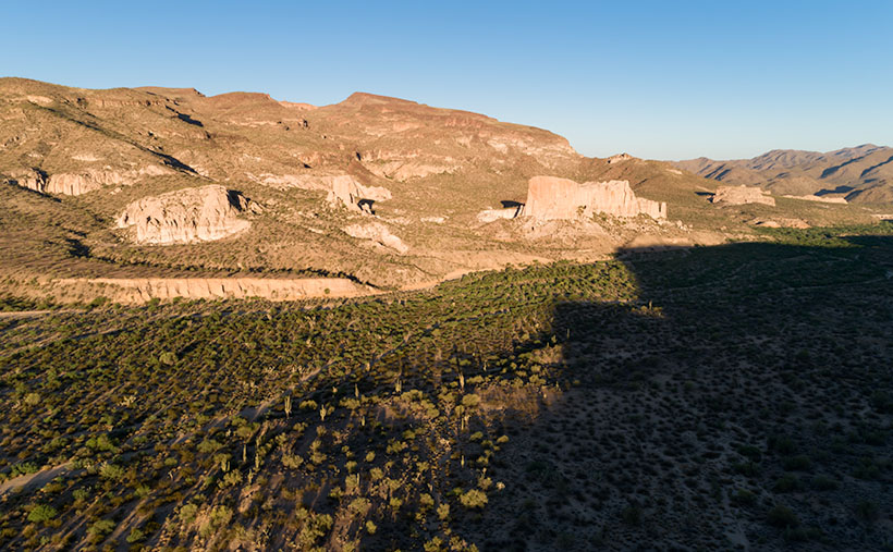
One of the landmarks along the road that I always looked forward to was along the Joshua Tree Parkway as the highway descends to the bridge crossing the Santa Maria River. Some large sandstone formations are hidden behind small hills just south of the bridge, and there’s a small gap where you can glimpse Shiprock. For decades, I planned a photography trip out there. The light was never right the couple of times that I tried.
Shiprock – Not the famous one on the Navajo Reservation that is spelled Ship Rock, but the lesser-known one right in our backyard.
The formations are at the eastern toe of the Black Mountains (yet another range with the same name—these are in Yavapai County) and on the other side of Black Canyon Wash, away from the highway. They’re too distant to get a good shot from the road. I found a Jeep trail that got me over the hill, but I needed something like Fred’s Toyota to go down the other side. However, our friends ran out on us for the summer before I could bum a ride.
I took this week’s featured image from the hilltop, and I think it gives a pretty good long view of the sandstone formation and the Black Mountains. You can tell that it’s spring because green chaparral and trees fill the wash. Shiprock is the middle formation (the shadows conveniently point at it). Its name comes from how the left side resembles the stern of an old pirate ship.
This photo also shows the Black Canyon Wash as it flows to the Santa Maria River, just beyond the photo’s right side. That river then flows between the Arrastra Range in the background and the Black Mountains to Alamo Lake. Everything in this picture behind the formations is part of the Arrastra Wilderness Area, so if you want to explore, you’ll do it on foot.
You can see a larger version of Shiprock on its Web Page by clicking here. Come back next week for another shot from around my neighborhood.