This is Augusts’ final post; the doves are skittery, there’s football on TV, and my astrological markers are lining up. Hmm—what do you think Mother Nature’s trying to say? For me, these are all precursors to summer’s end and the time when Arizonans will once again emerge from their dens. If we were smart, we’d form a committee to dress up a ground squirrel in a tux, call him Congress Cecil, and have him predict how many weeks of extreme heat warnings remain. The days will still be hot for another month, but soon the evening temperatures make being outdoors tolerable.
I should explain the skittery doves and astrological marker. September 1 is our state’s dove season, so doves begin to move to where the houses are because they have a better chance of not being shot. The day after hunting season closes, the doves return to the open desert and won’t be heard from until they get horny in the spring.
And yes, just like the ancient Anasazi, I have a special marker that precisely tells me when the spring and fall equinoxes happen. I didn’t carve a light-piercing spiral in sandstone as they did; instead, I use Bruce’s—my across-the-street neighbor—roof. Its ridgeline runs east-west, and on the mornings of the equinoxes, the sun comes up from its peak as I enjoy my coffee on my front porch. Y’all should come to join me on September 22. It would really freak out Bruce to see hundreds of people staring at his house at dawn.
As I said, this is the last image in my August cloud project. The monsoon took a vacation this week, so the sun’s brought the heat back. It’s had a chance to dry out, and now the yard’s full of weeds. But, Arizona Highway 89 is lined with orange poppies, and I spotted a couple of Palo Verde trees with yellow blossoms. It’s like spring again, and I’m getting that familiar wanderlust feeling.
Our monsoon will be back with a vengeance in a couple of days. There’s a hurricane traveling up Mexico’s west coast, and there’s a good chance it will come up the Gulf of California. When storms do that, it brings more than isolated showers—instead, the whole state gets soaked.
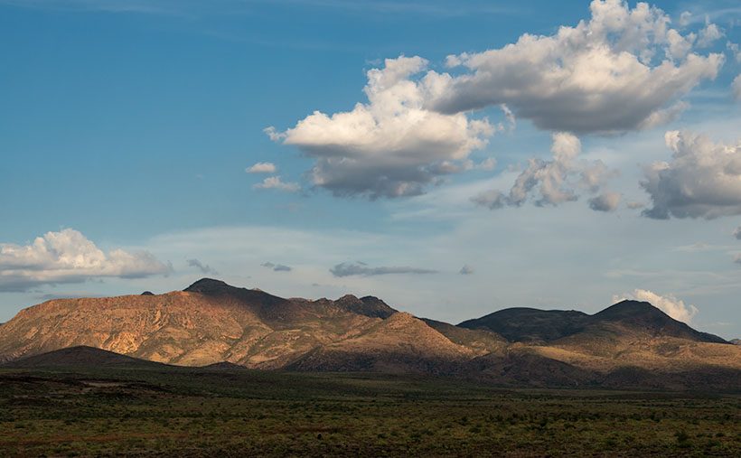
This week’s cloud picture kind of shows the weather’s dry break. The sky is clearer with scattered cumulus clouds. It also shows that it’s not just the puffy white sky-meringue that is pretty, but their shadows make the mountains more interesting. In the photo that I call North Weaver Shadows, we see cumulus cloud shadows cast on the north edge of the Weaver Mountains with help from the setting sun. This is my favorite image in this series because my familiar mountain range is different—more interesting. For your viewing pleasure, I also hid a black cow grazing on the desert floor somewhere in the picture—if you can find it.
You can see a larger version of North Weaver Shadows on its Web Page by clicking here. Next week, I’ll start a new September project. With the coming weather change, I hope I can get some shots in by then. So, be sure to come back and see if Dudley Duwright rescues Lit’l Nell from the railroad tracks in time (if you think about it—if he’s not in time, it’s not much of a rescue—is it?).
Until next time — jw