School Bus 11 Picture of the Week

The Summer of Love was 51 years ago. It was 1967 when a hundred-thousand flower children converged on San Francisco’s Haight-Ashbury District and challenged our worldly perceptions. At the time, I was on duty overseas, so I missed it. When I returned to the States the next year, I got married and had to pass up the free sex movement. Four years later my first wife divorced me and by that time, the movement was over. My timing has always been impeccable.

School Bus 11
School Bus 11 – An old school bus repurposed for other uses reminded me of the Summer of Love.

Before we retired, Queen Anne and I had the pleasure of attending seminars in the Bay area several times. On our last visit, we signed up for a walking tour of the historic old houses. On the tour, we learned that a by-product of the hippie period was the Painted Ladies. Needing a place to live, the invaders bought the cheap dilapidated Victorian homes that no one else wanted. Like any respectable homeowner, they began to restore and personalize the homes by painting them. Instead of using the traditional way—one muted-tone color—they made the house’s details pop with bright contrasting colors. These paint schemes shocked traditionalist, but it drew attention to how much craftsmanship went into building these old houses. It gave them character and made you appreciate them more, so the style of painting Victorian homes in multiple colors has become the norm. We even painted the shed we bought here in Congress with three colors and that shocked the neighborhood then.

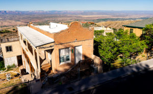
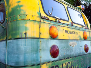
Last month, when I turned a corner in Jerome and saw this repurposed bus, it reminded me of those resourceful hippies and when I first visited the ghost town. There was a bit of tension in the old towns like Jerome and Bisbee then. People of my generation rejected the social norms and consumerist values of the period. They didn’t want to live in ticky-tacky tract homes and instead wanted a house that had character. They moved into Phoenix’s Encanto district and the abandoned shacks they found in these historic towns. They were perfect for making arts and crafts away from the rat race in Phoenix. The entrenched community pushed back. “We don’t want those weirdos living here, they’ll ruin everything.” Town hall meetings were often very heated and vocal and sometimes even made news in the Phoenix papers (yes, at one time, there were two papers). The conflict seems to have eased and there’s no apparent evidence of tension in today’s Jerome. It’s become a nice place to visit with the family, shop for mementos, and enjoy history—sort of a light version of Main Street, Disneyland.

The photo of the bus that triggered these recollections is called School Bus 11 and it’s my picture of the week. In it, I’m showing the essence of the school bus and its colors. The lights, the faded yellow, the rust, and the graphics tell stories about school children and—to me—the flower children of my past. I moved in to emphasize the patina, faded paint, and letters. From this close perspective, they become the composition and a story of yesterday.

You can see a larger version of School Bus 11 on its Web Page by clicking here. I hope you enjoy viewing my newest entry and come back next week when we move onto a new location for July.

Until next time — jw

WPA Sidewalk Picture of the Week

By now, you know that I’m a history buff—or perhaps I’m only interested in trivia. I don’t see the distinction, but I know I’m not cut out to be a scholar. I don’t have the patience to spend months in the Vatican Library tracing the origins of … anything. If Google or Wikipedia doesn’t explain, I move on. However, if someone mentions Hannibal, I think of elephants, not fava beans. I even watched all the James Burke’s Connections series—twice. I’m the only person that I know who has a personal copy of Arizona Place Names—and uses it. This probably explains why I write blog posts instead of novels, and it is the reason behind this thought I had when I published this week’s image—I wonder how many young people know the history of the sidewalk’s stamp.

While scurrying up and down Jerome’s hilly streets last week, I went into the Holy Family Catholic Church on Country Road for an interior shot. After that, because the day was late and I was out of breath, I returned to Main Street, where Queen Anne awaited me. A few stairs were at the end of the street, so I looked down to prevent falling. That’s when I first saw the stamping and decided that I needed to take another photograph. I call it WPA Sidewalk.

WPA Sidewalk
This section of sidewalk in Jerome is a museum piece that people walk on daily.

This is only the second existing example of a Works Progress Administration—renamed in 1939 as the Works Project Administration; it was the depression era program that employed people for public works projects—that I have cataloged in my brain’s world map. The other is a bridge on the US89 north of Flagstaff. (Maybe finding and shooting WPA sites would be a book-worthy photography project.) Jerome has already replaced many of its walkways with ADA-compliant versions. They had to because of age, winter freezing, and earth movement, but this one is still in good shape and used daily. With the hand-scribed lines (for better footing?), it’s certainly different from the sterile versions that machines spit out today. Since it’s over fifty years old, it probably qualifies for protection under the American Antiquities Act. This sidewalk is the only museum piece I know you can leisurely stroll down.

You can see a larger version of WPA Sidewalk on its Web Page by clicking here. I hope you enjoy viewing my newest entry and return next week when I post another Jerome photograph.

Until next time — jw

House with a View Picture of the Week

It’s June already and our wall thermometer is reading over 100º so it’s time to shoot somewhere a little cooler. Queen Anne and I racked our brains to come up with a scene close enough for day trips, and we decided to focus on Jerome this month. It’s a ghost town close by, it is a mile high clinging to the side of Mingus Mountain, and it is cooler than here. I have personal recollections about Jerome that I plan on sharing later this week, but Sunday’s are reserved for new picture announcements, so let’s get on with it.

I’ve photographed Jerome several times over previous decades and I already have a library of the town’s familiar buildings, so on this trip, I wanted to look for details that give Jerome character—you know—the artsy pictures. I got some shots that fit that bill, but to set the stage for Jerome Month, I wanted to start with an image that would give people who have never visited the town an idea of its geographical placement, and I think this week’s featured image does that.

House with a Veiw
House with a View – Building and maintaining a home on a mountainside is a daunting task. But like this house in Jerome, the views are priceless.

I call this image House with a View and it is one of the few private residences that has survived intact. It’s a modest home that is one story on the street but has three levels at the back. It’s a brick building indicating that it was home to a family of means—like a mine manager. To me, it shows how steep the slope of the lot it’s on and how much engineering it took to keep the house from sliding into Clarkdale below. Conversely, the upside of being tethered to a mountainside is the million dollar view of the Verde Valley two-thousand feet below—and to the north, the red rocks of Sedona. Can you imagine having cocktails on that veranda while watching the sunset on the southern edge of the Colorado Plateau?

You can see a larger version of House with a View on its Web Page by clicking here. I hope you enjoy viewing my newest entry and join Queen Anne and I as we show off Jerome this month.

Until next time — jw

False Cave Picture of the Week

This week’s featured photo concludes our May adventure to Alamo Lake’s mud cliffs. I have another couple of detail shots that would fit nicely into this grouping, but I’ve run out of weeks this month and we have other places to go. I suppose I could put together a set of six and make up a folio like Santa Lucia Fog, or maybe I’ll go back and shoot enough images to complete a portfolio. I’ll have to think about that—what do you think?

False Cave
False Cave – This appears to be the opening of a shallow cave, but it’s not that simple.

May’s final image looks like I shot the mouth of a shallow cave with—if you squint and let your imagination go wild—a pair of cherub heads as keystones, and that’s exactly what it looks like when you approach this structure in the field. But there’s something in the photo that gives a clue that this isn’t a cave. It’s the light shining on the floor past the opening. If you crawled into the cave where that light area is, you could stand up—or you could just walk around the pile of mud to the left, and come back down the stream bed. This is actually a low arch that is torso high. If I had a model, her legs would show in the lower opening while her head and shoulders would be visible on top. It would make a unique open shower design—like you would have poolside.

In all honesty, I wasn’t creative enough to come up with that idea. The woman in spring’s photo class, whose images inspired me to visit this place, came here with a group, and one of her friends posed behind the arch. Except he was a guy and he wasn’t naked. When I walked up to this spot, I wasn’t sure it was the same because it’s so well camouflaged. If I do go back for a reshoot, I’ll need to have a model join me. What are the odds of that happening: me—a toothless old geezer—convincing an attractive woman to go with me to this barren wasteland so that we could shoot that picture? Yeah, I didn’t think so either.

You can see a larger version of False Cave on its Web page by clicking here. I hope you enjoy viewing my newest entry and join Queen Anne and I as we present new photos from a different location—this time in Yavapai County.

Until next time — jw

The Spout

This week’s featured image is the third of my Mud Cliffs series that I’ve written about for the last couple of weeks (here’s the original). In the first post, I started at the mouth of the slot canyon and last week, we got to the narrow passageway’s end—or the head. Today, we begin filling the spaces between.

The Spout
The Spout – With a low sun showing the cliff face structure, the low point turns into a waterfall during stormy weather.

I shot today’s photo, like the first, late in the day on the outbound hike—after the light turned to gold. The low sun adds a warm color to the mud and, in this case, really shows the pillar structure in the sediment. All though, I wouldn’t want to put myself in that kind of danger, I can imagine a temporary waterfall pouring over the spout between the mounds during a summer monsoon. I’ve seen it happen at Lake Powell. We were exploring a similar canyon by boat when an afternoon deluge hit us. It was a Disneyland ride with waterfalls all around. Fortunately, we weren’t hiking and need to worry about escaping a flash flood.

You can see a larger version of The Spout on its Web page by clicking here. I hope you enjoy viewing my newest entry and tag along as we look at the canyon walls for the next couple of weeks.

Until next time — jw

Bat Ears Picture of the Week

A couple of weeks ago, I drove to a part of Arizona that I hadn’t seen before. I knew about Alamo Lake as a fisherman but never went there because it wasn’t stocked with trout, and the fishing reports always warned about rattlesnakes. That was enough to put me off. But, during our club’s spring classes, one of the students brought in photos from the Alamo area that I found so interesting that I changed my opinion about visiting the La Paz County lake.

She took photos east of the lake, where Date Creek cuts through an ancient mud deposit. Because of how the intermittent water has eroded the soil, the place is known as Mud Cliffs. It’s not shown on any maps I have, but I knew it was the general area, so I left the house with enough time to explore and still have a couple of hours to shoot before sunset.

From Wenden, the paved road to Alamo State Park runs due north. It has little or no traffic, and it only took me an hour to get to the park store. When I asked the friendly staff inside about the cliffs, the host handed me a hand-drawn map. “Head toward Wenden to the Wayside Road, then jog over to Palmerita Road and follow it north.”

“Thanks,” I said as I took the map and paid too much for a Butterfingers candy bar and the park’s day fee—even though I was leaving.

During the classes, my student said her group was out on ATVs, but she believed you could get there by car. She was right. All the roads were wide and well-graded, and when I drove them, they didn’t have a lot of washboards. After I reached the spot on the map, I searched for the canyon shown in her pictures, and when I found it, I spent an hour or so hiking and shooting the photos that I’ll be sharing this month—I guess it’s Alamo Lake Month.

Bat Ears
An erosion formation at the head of the slot canyon glows in the late afternoon sun. The pair of points on top reminded me of a bat or maybe even Batman.

This week’s image is called Bat Ears, and I took it at the slot canyon’s mouth towards the end of the day. I passed it going in, but the sun didn’t have the same warmth as in this image, so it wasn’t interesting enough to shoot. The name comes from the pair of points at the top. This cliff doesn’t have a name—none of them do. Because the soil is so soft, it quickly erodes. A good flood will wipe out the existing landscape and replace it with new formations. The ears may not last another year, so I got to name a geological feature that—maybe—no one else will see. My chest swells with pride.

You can see a larger version of Bat Ears on its Web page by clicking here. I hope you enjoy viewing my new entry, and I hope you’ll tag along as I work my way up the canyon. It’s a pretty exciting hike.

Until next time — jw

Reach for the Sky Picture of the Week

I drove down past the Safeway into the Vulture Mountains last evening to do some photography. My intent was to capture an image of Vulture Peak shining in the sunset, so I drove around until I found an angle where I could get the image that I visualized and set up my camera. It didn’t work. From the spot I was shooting, it would work better as a sunrise shot. While at that scene, I saw this funny little saguaro on my right and decided to shoot it instead. I call it little, but even with its center trunk lopped off, it’s taller than I am.

Reach for the Sky
Reach for the Sky – A near-full moon rises behind a decapitated saguaro in the Vulture Mountains.

By the time I got set up for this image, the sun was down and it was already into the blue hour—the period after the sun has set but still light enough to see colors. It wasn’t until I began to concentrate on the saguaro that I noticed the near-full moon rising, so I’m going to toss it in for no extra charge. The cactus is interesting for a couple of reasons. Somehow it lost the top of its main trunk and it has sprouted new arms, of which one looks like a melon … or even a head if you have a vivid imagination. The second notable thing is that it’s still plump with water even though we haven’t had rain for months—which may be the reason it was able to generate the new growth. In any case, it has cool apartments for woodpeckers, cactus wrens, and maybe an owl family this summer.

I called this shot Reach for the Sky and you can see a larger version of it on its Web page here. I hope you enjoy viewing my new pico’-week and that you’ll tell me what you think. Maybe next week, I may get out of bed early enough to get a better version of my first idea.

Until next time — jw