April Sunset Picture of the Week


April Sunset
April Sunset – After a flat and dreary day, a weather front breaks up at sunset.

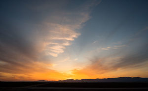
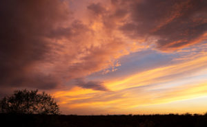
Life is full of ironies. After writing last week about sunsets, I spent most of Monday working in my wood shop. A weather front had moved in overnight and most of the day was flat and overcast. The disturbance brought snow to the high country but nary a drop of rain to the desert. It was a good day for working indoors. However, late in the afternoon, I noticed that Chuck and Kay’s house—our neighbors from across the street—was bathed in sunlight, which made me walk to our deck out back so I could see the western sky. I watched the clouds beginning to break up and leaving a clear sky behind them. From experience, I knew that meant that there would be a colorful sky once the sun dipped below the horizon. After writing a week ago that I have been too lazy to chase sunsets, I decided to make a lie of that comment, so I gathered my gear and when the time was right, I drove to a place where I had a clear view of the horizon. I took my time and recorded the psychedelic scene until it faded. Of the fifty images that I captured, I liked this one best and I call it April Sunset.

As opposed to the simple streaks of colors in last week’s photo, this one is about textures; all kinds of different textures. The streaks of yellow, the wisps of the pink cotton candy stand out against the single patch of blue. As I shot, there was color all around me, but there was only one area having a dark pile of cotton balls seen in the upper right and this was the shot best showing those lumpy edges as they grabbed the sun’s rays.

You can see a larger version of April Sunset on its Web page here. I hope you enjoy my new work. Tell me how you think it compares to Harcuvar Sunset, its predecessor?

Until next time — jw

Harcuvar Sunset Picture of the Week

There are good days and there are bad days. I have been out on photo shoots where nothing went right, and then there have been days when everything was perfect. This week’s photo is from one of my better days. Last week, I went on an expedition to Alamo Lake—a place I hadn’t visited before—because I saw a place in a student’s assignment that I wanted to photograph. I spent several hours driving to La Paz County and an hour searching for the right place. I spent another hour or two walking and shooting before I felt like I had what I wanted and packed up for the long drive home. As I got closer to home, the sun was setting and when I turned onto State Route 71, this was the view out of my door window so I pulled over to capture it.

Harcuvar Sunset
Harcuvar Sunset – After a day of shooting in the desert, I stopped on the drive home to take one last photograph.

I’m pretty ambivalent about sunset photos. They’re beautiful and all, but they’re everywhere. When I was younger I shot a lot of them, then I went through a period where I ignored them. Maybe I’ve mellowed in my old age because I feel like I’ve passed up some spectacular shots because I was too lazy to drive to an open field and I promised myself to rectify that.

This shot—called Harcuvar Sunset—is interesting to me because of the cloud layers. The sun’s last rays color the low clouds while the higher upper streaks are still white. The contrail—usually something that meddles in a photo—seems to be caught in the space between them. I captured this scene at the edge of an alfalfa field in Aguila and the mountains are the Harcuvar Range—I was shooting on the north side of them for most of the day.

You can see a larger version of Harcuvar Sunset on its Web page here. I hope you enjoy my new work and that you’ll tell me what you think. Do you think sunsets are beautiful or are they trite and overdone?

Until next time — jw

Yarnell Overlook Picture of the Week

For each picture of the week in this series, I normally select the best shots from the locations that I’ve written about. This week is a little different. I had to push back the scheduled image that I was going to use so I could insert a shot that I took yesterday. I intended to just shoot some test shots, but because this image fits into the current theme and because it came out better than expected, I decided to insert it into this week’s rotation. It’s called Yarnell Overlook named so because that’s where I shot it.

Yarnell Overlook  – The vista from the Yarnell Overlook takes in Fools Gulch in the foreground to Harquahala Mountain—fifty miles to the west.


I ordered a tripod part from Amazon that arrived Friday and I was anxious to put it to work, so I decided that I would ‘run up the hill’ at sunset and test it at the overlook. It was an easy place to get to and there’s little traffic there. During the day, I was concerned because of a boring cloudless sky and the winds kicked up a layer of dust making the atmosphere hazy. I resigned myself that the results would technically be OK,  so I didn’t expect more than that. As sunset approached, however, a few puffy clouds began forming near the Weavers which picked up my spirits. After dinner, I packed my gear into the car and set off for the pull-out located half-way up Yarnell Hill to conduct my test. The view from the overlook is most often hazy and the back-light from a setting sun is even worse for shooting a high detail photo.

After I processing the test, however, I think the results exceeded my expectations. Although the dust obscures the fine detail and acts, well … like fog adding some drama. I like it because of the afternoon clouds above the layer of dust. The viewpoint overlooks Fools Gulch with its working gold mine. The Stanton road that I wrote about for the last couple of weeks is just beyond the very large Parker Diary Farm that you can see in the middle-right. The last thing that is pleasing to my eye is the repeating round shapes of the boulder-covered foreground hill and Harquahala Mountain—some fifty miles away on the horizon. In case you’re curious, our house is located in a lighter patch of homes near photo’s center.

You can see a larger version of Yarnell Overlook on its Web page here. In last week’s post, I mentioned using a Like button. Fred correctly pointed out that when you follow the post links, there isn’t such a button. There are Like and Share buttons, but they are only on the blog’s homepage. To access that version, you need to first open my Webpage and click on the Blog link in the menu. That sounds like too much trouble, so I won’t bother mentioning them again. No matter which version you see, I hope you enjoy viewing my newest work.

Until next time — jw

Stanton Street Picture of the Week

This week’s new image shouldn’t be a surprise. I sort of previewed it in the last post. It is the row of houses that I took while visiting the ghost town of Stanton last week. If you missed the post you can scroll down to learn more about the gold and the shady characters that lived there. Maybe not as exciting as it was, Stanton, is now an RV Park where baby boomers like me can spend their vacations panning for gold.

Stanton Homes
Stanton Homes – Only three houses have survived the years of abandonment. They line a street surrounded by campers.

It was late in the day when I finally got to Stanton and the light was low with long shadows. I had watched the sky during the day thinking I may not go because it was gray and uninteresting, but in the afternoon, the clouds broke up into puffy finger-like shapes with a good light underneath. I started shooting the front buildings first, frankly because of the old signs on them, and when I satisfied myself that I had got what I wanted, I walked up the dirt street where this row of homes is. I loved the soft light falling on the white-washed buildings. The light wasn’t too harsh that it blocked up the shadows, yet it still showed off the building’s dimensions. Because the sky was so striking, I backed off from the homes to include the clouds. I think this shot came off as more than a house picture. I see it as a specific instant of time when the light was weird and the clouds were right. I’m very happy with it.

I named this shot Stanton Street and now you can see a larger version of it on my Website by clicking here. Please feel free to share your thoughts in the comment section below and don’t be bashful about clicking on the Like button if you enjoy what we’re doing.

Until next time — jw

Black Butte Picture of the Week

The Vulture Mountains are a twenty-nine-mile long collection of volcanic hills south of Wickenburg. The Hassayampa River runs along the range’s eastern boundary and the mountains taper off to the west. From our Congress home, two peaks rise out of the low mounds on our southern horizon: Vulture Peak’s rounded knob is to the left and the sloping top of Black Butte is on the right. Reminding me of a doorstop or a fallen cake, Black Butte is the subject of this week’s photo.

Black Butte
Black Butte – With its distinctive sloping top, Black Butte marks the western boundary of the Vulture Mountain Range.

The slanting top of Black Butte first caught my attention while I was still working. I drove the forty mile trip from Wintersburg to Congress on the Vulture Mine Road and the butte marked the place where the road turns north. I thought that its shape was the kind of thing you’d see in old western movie backgrounds. I knew that I would use it as a subject some time. A couple of weeks ago while I was shooting in Aguila, there it was waiting for me bathed in late afternoon light.

You can see the larger version on my Website by clicking Here. I hope you enjoy viewing it and I’d love to hear your comments below.

Until next time — jw