Placerita Hills Picture of the Week

While having this morning’s coffee, I sat on the front porch and watched the sunrise over the Weaver Mountains. That’s the best view from my house, but there are still homes and trees in the way, so I can only see their tops unless I walk down to the end of the street. Since the elevation here is 1500’ higher than the Phoenix basin, the mornings are still cool—even in June. Because my porch faces east, all of that pleasantness comes to an abrupt halt the second the sun clears the horizon. Then I’m forced to retreat to the back where I have a spectacular view of my neighbor’s shed.

When we moved here almost five years ago, I knew nothing about the Weaver Range other than their name. With time, I learned more about their secrets as I researched the subjects I photographed. I fear that by the time I run out of film, I’ll become a sort of grizzled old Gabby Hayes wandering the Wickenburg streets, wearing a torn cowboy hat, a mouth full of chaw, and spinning yarns about mountain ghosts, so the tourists will give me loose change.

The Weaver’s have been at the center of my attention for a couple of months now because they’re the subject of my third drone video that I’ll finish in a couple of weeks. For the video, I made a list of points to film, and I’ve grappled how to describe the range best. On the way to the Prescott Costco last week, I blurted to Anne, “They’re like a horseshoe wrapped around Peeples Valley.” She said, “Huh?” I probably should have started with some context. Then I came up with a better metaphor. They’re more like the palm of your left hand—not the Michigan one.

The Weaver Range - The geography of the Weaver Range can be summed up on one hand, but you have to use the correct one.
The Weaver Range – The geography of the Weaver Range can be summed up on the one hand, but you have to use the correct one.

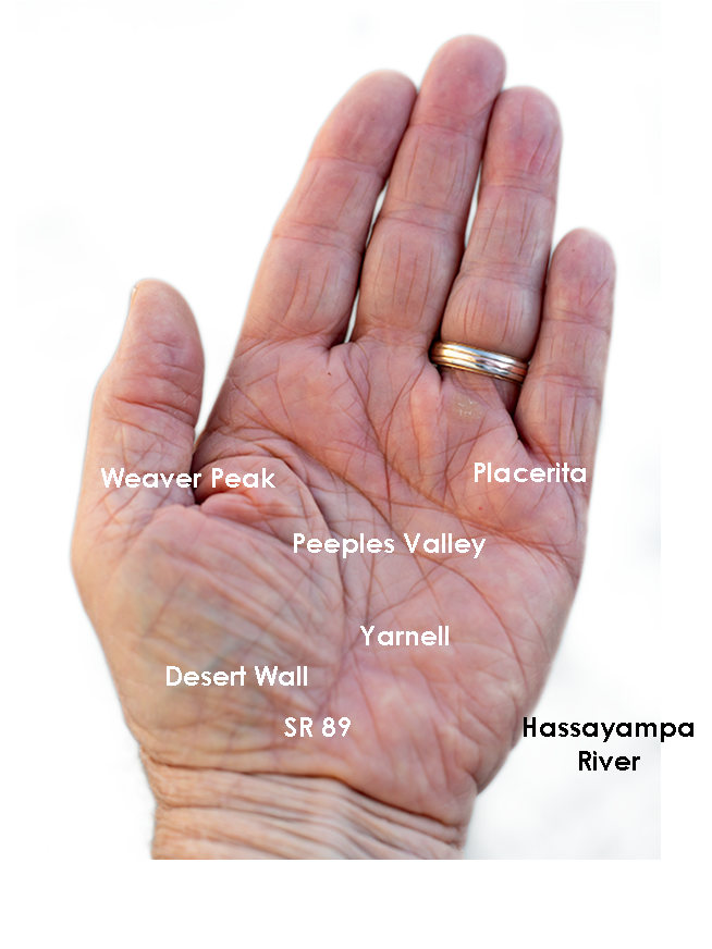
Use your imagination. Peeples Valley is the depression in the center, and State Route 89 is your life-line ascending from your wrist up Yarnell Hill to the little town at the pass. The Weaver’s tallest peaks are along with the thumb, and where gated communities of summer homes are. The desert wall (the northern boundary of the Sonoran Desert) is along your wrist. The area under your little finger represents the lower eastern peaks—more like rolling hills. The Hassayampa River separates the Weavers from the Bradshaws. The area that we’re exploring this month is at the base of your little finger.

Placerita Hills - The east flank of the Weaver Range are hills than tall peaks.
Placerita Hills – The east flank of the Weaver Range are hills than tall peaks. On the distant horizon is Weaver Peak which is on the other side of Peeples Valley, and is the range’s tallest peak.

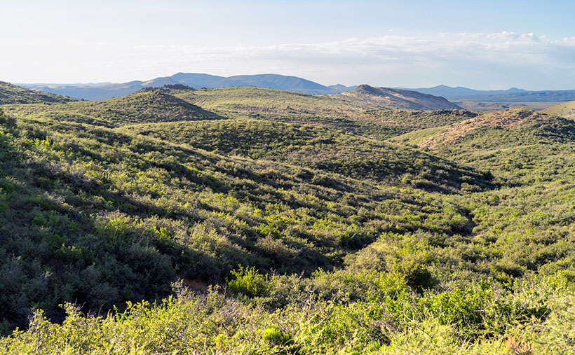
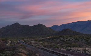
The east flank of the mountain range doesn’t have any soaring peaks, at least not when you drive in from Peeples Valley. The mountains are more like rolling hills, as seen in this week’s featured image that I call Placerita Hills. To get there, you have to drive up a long gradual incline. The hilltops have granite outcrops that are like miniature versions of eastern and southern peaks. In the photo, the dense vegetation is very evident and is a mixture of Manzanita, Scrub Oak, and some others that I’m not able to name. Unlike the desert floor, there’s no space to walk, and it’s easy to understand why cowboys wear chaps. The mule deer that we saw bounced over the brush instead of running through it. It’s incredible to me that the area’s ranchers can raise cattle here.

You can see a larger version of Placerita Hills on its Web Page by clicking here. I hope you enjoy it. Come back next week to see what else we found along the road to Placerita.

Until next time — jw

Sunrise on Track Picture of the Week

There are only a half-dozen places Queen Anne, and I frequent in our home town of Congress. There’s Nichol’s West—our favorite local restaurant, the Post Office, the clinic, the Kwikie Mart, and the Dollar Store. Oh, I forgot the dump. For anything else, we have to drive into town or—shudder—the big city. Half of those in-town destinations are on the west side of the railroad crossing, which never has a train—most of the time.

I wrote in a newsletter about our train when we first moved here. This section of track is called the Pea Vine Grade that follows Highway 60 out of Sun City till Wickenburg then continues north to Prescott and Ash Fork. The name is descriptive of the twists along the route.

The tracks aren’t busy like the southern route in Yuma, or the north through Flagstaff. This route isn’t bustling and only has four to six passing trains each day. They’re not on any schedule that I can discern and you don’t hear them go by as much as you feel their bass vibrations, especially the ones coming up the grade. The five engines work hard dragging loaded freight cars up the hill, while the ones headed south sound like a wooden roll-a-coaster as they effortlessly roll downhill. Their horns only blare in Wickenburg and the Congress crossings. That’s too far away to hear from the house unless we’re sitting on the back porch and there’s a north breeze coming off the mountains, but even that’s so faint that it’s like a scene from a Steinbeck novel.

Sunrise on Track
Sunrise on Track – Dawn breaks with a red sky over the railroad tracks heading north from Congress Junction.

This week’s featured image turned out completely different from how I originally visualized it. I wanted to capture this shot with a train in it. The tracks come into Congress Junction from Hillside through the valley between the Date Creek Range and the Weaver Mountains. On most mornings, there’s an early southbound train. We’ve seen it while we’re out for our morning walks. To further set the scene, the Date Creek Range foothills at the crossing are prettiest at sunrise. The rest of the day, they’re flat and dull. So that’s what I had in my mind when I drove there in the dark.

I previously scouted out a lovely spot overlooking the tracks, and I set up my camera and waited for the characters to arrive. As the eastern sky got brighter, the clouds overhead turned red, and I thought, “Ooo shiny.” I fired off a couple of frames. As I waited, the fast-moving clouds moved east and began to block the sunrise removing any drama from my scene. Besides, no trains showed up. Disappointed, I packed up and drove around town looking for other subjects to shoot.

When I got home and reviewed my images, this was the shot that impressed me the most. Even without a train, the tracks are a leading line that moves your eye to the foothills.  The light bouncing from the clouds tints the scene pink, and that light softly brings out the mountain’s cone shape. There is a feeling of tranquility in this shot. It’s a moment of quiet and calm.

You can see a larger version of Sunrise on Track on its Web Page by clicking here. I hope you enjoy viewing this week’s post and next week; we’ll show another featured image from Congress.

Until next time — jw

Stanton—The Outlaw Ghost Town Under Yavapai Skies

My lovely bride abandoned me for a couple of days to get her annual check-up at a beauty spa on the Arizona Rivera—Lake Havasu City. Before she climbed into her friend—Yasmeen’s—car, she turned to me and with a pointed finger and sternly said, “I have two words for you. Be – have!” Well … that sounded like a challenge to me, so I began thinking about what kind of trouble I could get into. I was in the mood for a photography outing and I hadn’t been to Stanton since Fred and I got lost, so I tossed my gear into the truck and set off to get some new photos.

Hotel Stanton
Hotel Stanton – During the Summer of Love, hippies moved in and set up a commune. Unfortunately, they tore down many of the old buildings for firewood. LDMA has slowly repaired the remaining structures since acquiring the town in 1976.

Stanton is one of the many towns in mountainous Yavapai County (rhymes with have-a-pie) where, because someone discovered gold, a town sprung up overnight and disappeared just as quickly when the ore played out. It was little more than a stagecoach stop on the Wickenburg-Prescott road at  Antelope Creek until a tracker named Alvaro chased an errant burro to the top of what is now Rich Hill. When he got back to camp and told the expedition leader—Pauline Weaver—about finding gold nuggets “the size of potatoes” on the summit, you can surely guess what happened next.

Opera House
Opera House – The Opera House is an adobe building with a brick façade. It’s now used as a meeting hall for the RV Park.

The town—known at the time as Antelope Station—got its name from an unscrupulous character named Chuck Stanton who moved to the thriving community several years later. Stanton opened a store and, with the help of his hired banditos, killed off his competition. His reign didn’t last very long as he was shot and killed that same year (living with swords, I guess). The town thrived afterward for several decades but it had a bad reputation. “In 1892, for example, a Prescott newspaper reported that the residents of Stanton liked to ‘drink blood, eat fried rattlesnakes and fight mountain lions’” (Wikipedia). By 1905 the gold ran out and Stanton was abandoned.

Stanton Homes
Stanton Homes – Only three houses have survived the years of abandonment. They line a street surrounded by campers.

Ownership has changed several times since then and now it belongs to Lost Dutchman’s Mining Association (LMDA) and they have turned it into a member’s only RV Park. Membership is kind of pricey but LDMA has methodically bought up mining claims in the area and its members can work those old claims without charge. It’s surprising how many people will pay good money to play in the dirt—I don’t even like to plant flowers. Guests are allowed to visit but they first have to stop by the office and sign a release.

After my visit this week, I drove further down the road to the old Octave and Weaver mine sites and saw people on either side of the road prospecting. Late in the day, I stopped to take a photo along the roadside at quitting time when several trucks pulled out of a side road. They all slowed and waved and one of the men stopped to ask if I was getting some good shots. I asked him how his day went.

“What do you mean?” he asked.

“Did you make a fortune today,” I explained.

He laughed and replied, “Only the boss makes any money.”

“I see.”

Then he started telling an old joke, “Do you know how to make a small fortune in placer mining?”

“Yeah, you start with a big fortune,” I responded.

With that, he laughed and drove off in a big trail of dust.

Until next time — jw