Shell Station Lowell Arizona

Shell Station - A small Shell gas station is located at the north end of Erie Street in Lowell, Arizona.
Shell Station – A small Shell gas station is located at the north end of Erie Street in Lowell, Arizona. The 51 Chevy parked out front was a nice touch. The pumps are priced at 41 cents per gallon if you’re interested.

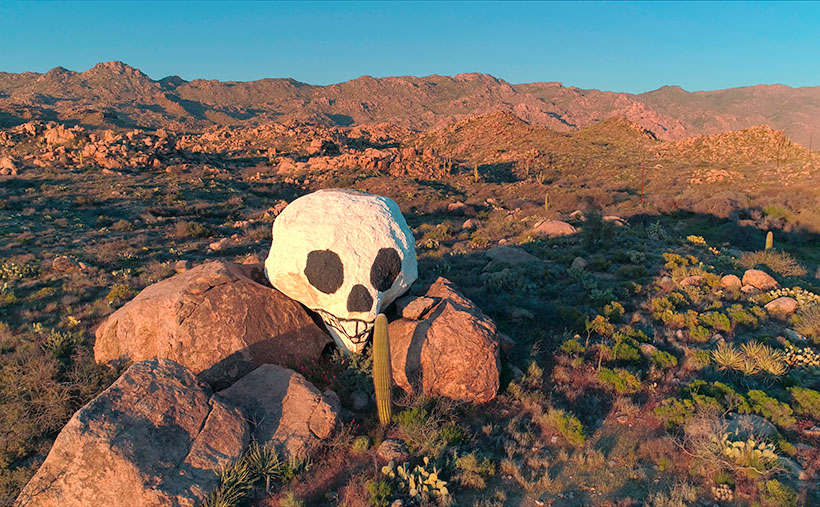
Maybe I’m doing this wrong, but I’m a photographer first and a storyteller second. When I’m out taking pictures in the field, I don’t have a story in mind that I have to illustrate. My stories come after I’m at my desk trying to explain why I bothered to snap the shutter. Some weeks I struggle to put together two pages of sensible words; other times, my thoughts fly at my keyboard, and my fingers seem to move barely.

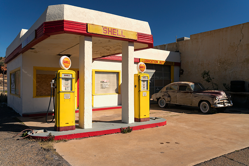
When Queen Anne and I happened upon Lowell and made our unplanned stop, I hopped out of the car and started snapping pictures down one side of Erie Street and up the other. When I returned home and processed the images, it was like there was a story in me begging to be told—and these were the perfect pictures to hang them. Like the rest of February, this week’s featured image, Shell Station—has a built-in untold story about my first real job.

I never got an allowance when I was in high school. My dad paid me to work at his drapery factory after school and on weekends. It should have been the perfect arrangement because I was mostly alone. I hated it because it was repetitive work, and it had nothing to do with cars or girls—besides, dad always thought I was goofing off—which I was.

The summer of my graduation, Dave—a good friend of mine—asked if I’d be interested in working evenings at his brother’s gas station. George—the owner—was short a person and needed someone dependable. I went for an interview, and George wanted me to start that very Saturday so that he could learn-me-up on how to pump gas. On Saturday, I was still in bed when the phone rang, and I vaguely remember driving to Van Nuys half dressed.

George’s station was an Atlantic-Richfield (ARCO now) on the northeast corner of Van Nuys and Magnolia Boulevards. It was about three times the size of the Shell Station in this week’s picture. He had three gas islands and two service bays, open 24 hours daily. My salary was only 1.65/hr, but because it was a service station, we got a commission on everything but gas. That’s why we were so happy to wash your windows (blades), check your oil (air filter), and your tire pressure (if you sold a set of tires, you were golden). Although it was common then, we didn’t pressure the customers to buy anything—we’d show them the evidence and let them decide. It worked for me, and I could make an extra $5.00 weekly.

There was another significant aspect of George’s station. I don’t know if you did this in your part of the country when you were a teenager, but cruising was extensive on the west coast. Every Friday night, pimpled face adolescents from across the valley would pile into shiny cars and drive up and down Van Nuys Boulevard. The guys paired up in someone’s hot rod, and the girls rode around in daddy’s T-Bird. Our traffic pattern started in Panorama City, south through Bob’s Big Boy, a turn around at Magnolia, and drove back to the beginning. There wasn’t any point to it other than to see and be seen (and it annoyed older people). If you need an example, run to Blockbuster Video and check out the movie American Graffitithat was us.

Our station was at the loop’s south end (less than a mile from Bob’s), and we’d have more traffic driving behind the gas station every Friday night than we did out front the rest of the week. Since we were convenient, the kids took advantage of our restrooms. From the horror stories I heard, I’m glad I wasn’t part of the Saturday morning crew that had to clean them.

As you’ve heard, everything shall pass, which also happened with George’s station. As property values rose in the San Fernando Valley, the gas station’s land was so expensive, Atlantic Richfield sold the land to a developer who built a high rise. George got an amicable settlement and a much smaller station in Reseda, which closed at 9:00 pm each day and didn’t open Sundays and holidays. I worked at that station until I got drafted. Besides getting my first drag racing ticket on my way home, I don’t have any interesting stories from there.

You can see a larger version of Shell Station on its Webpage by clicking here. This completes our February visit to Lowell, so we’ll move on next week. Come back and find out where the road led us—won’t you?

Till next time
jw

BTW:

Did you work at a gas station? How do you think they compare to the self-service ones we have today? Do you feel the cars get as much care as they need?

Colton Crater Juniper Picture of the Week

Colton Crater Juniper - A lone juniper surrounded by lava bombs stands before Colton Crater topped with monsoon clouds.
Colton Crater Juniper – A lone juniper surrounded by lava bombs stands before Colton Crater, topped with whipped cream monsoon clouds.

I’m unsure where my head was last week when I wrote that today was the last Sunday in October. It wasn’t until the middle of the week that I realized I was wrong, and another weekend was ahead. Don’t worry; I have one more photo from the San Francisco Lava Field that I’d like to show you. You’re so lucky.

Queen Anne and I didn’t have to travel far from S.P. Crater to find this week’s scene. She didn’t move at all. She sat in the Jeep and continued to read her Kendal while I walked due south across the dirt road to a tree that I found interesting. I composed my shot as I walked toward the juniper. I wanted to include the monsoon clouds building over the San Francisco Peaks and some of the lava bombs surrounding the tree; otherwise, I would have moved closer to capture its twisted trunk. When I finally processed the photo this week, I realized that I had grabbed another volcanic crater—it’s a twofer. I’d rather be lucky than good—it takes up less time.

The cone in this week’s shot is Colton Crater. It looks like a fallen birthday cake. No amount of icing will cover that mess up. Compared to the mountain I featured last week, this one doesn’t seem impressive. It doesn’t look tall and well-formed like S.P. Crater. That’s only an optical conclusion. Colton has more height and width, and the caldera is deeper. And there is another smaller cone inside Colton’s caldera. You’ll have to look on Google Earth or hike its rough grade to see it. Incidentally, along the horizon, the small pyramid-shaped peak is Mt. Humphreys—Arizona’s highest mountain peak.

The reason that Colton looks old and saggy is the same as why I do; it’s an old fart. While S.P. Crater’s last eruption was only 55,000 years ago (a baby), Colton Crater hasn’t seen any action in 200k – 800k years. That’s plenty of time for gravity and erosion to bring a mountain to its knees. For example, the interior of Colton’s crater has been swept clean of residual ash and pumice from its eruption.

Scientists don’t name things very creatively. They tend to give out codes instead of names. For most of the time that geologist has been studying the San Francisco Peaks, this crater was called V160. It was the 160th volcanic flow in the lava field. See what I mean—where’s the romance in that? Dr. Harold Sellers Colton was the founder and director of the Museum of Northern Arizona in Flagstaff, and after he died in 1970, the local academia renamed Volcano 160 in his honor. That was nice.

You can see a larger version of Colton Crater Juniper on its Webpage by clicking here. Come back next week when we finish our tour of the San Francisco Lava Field with one last photo. This time I’m sure—I looked it up on my calendar. We’ll see you then.

Till next time
Jw

BTW:

I have an old friend from my California racing days named Gary Wheeler. You might have read some of his comments in this journal. Since his retirement, he has been taking some fantastic bird photographs. I don’t know; maybe old racers turn to photography when they’re too old to do anything useful. After much urging, Gary has put his collection online for people to enjoy. If you enjoy birds, you should pay a visit at: https://gowheeler.smugmug.com/. Don’t worry; he didn’t pay me for this advertising.

The Grotto Picture of the Week

Grotto Interior - From the outside, the Grotto looks like a secluded place to hide from the world.
Grotto Interior – The Grotto looks like a secluded place to hide.

Over the past couple of weeks, we’ve been hiking and photographing the Grotto Trail in the Chiricahua National Monument. I know that seems like a long time for a one-mile trail, but I’m old and quickly fall. As you’ve seen in previous photos, massive rock formations that sometimes resemble sculptures line the track. That’s another reason the hike takes me so long—I can’t pass up these shots.

As I walked through the towering erosion formations, I wondered how the grotto would look. By definition, they’re a ‘picturesque cave,’ so I wasn’t sure what I was looking for. I shouldn’t have worried because, as that old proverb goes, “You’ll know it when you see it.” That’s precisely what happened. When I first peeked through a side window, I shouted, “Eureka, I’ve found it.”

It’s a cool room with light filtering in from outside. Four pillars line the room and hold up a slab of stone that fell on top. If you aren’t my size, you can crawl up inside and take a nap or play tea-time should you happen to bring your Barbie set. Because it’s open to the sky, you wouldn’t be able to take shelter from a storm like you’d be able to do in an actual cave.

Grotto From the Trail - When I looked back at the Grotto from the trail, I could see how it was assembled.
Grotto From the Trail – I could see how it is assembled when I looked back at the Grotto from the trail.

After catching my breath for a minute, I started back to the parking area. I was only a few steps down the road when I turned around and shot this second image. It gives you a better idea of how the Grotto is assembled, and quite frankly, it doesn’t seem to be a secret room—just an interesting pile of rocks. You can see a larger version of The Grotto on its Web Page by clicking here.

Since today is the last Sunday of the month, this is the end of April’s Chiricahua project. I took many more pictures, but I couldn’t show you all of them in only four weeks. If only there were another way for you to see them. Oh wait, there is.

Wrote a book about it—wanna see it?—here it is.

Chiricahua National Monument – My new photo essay of our trip to Cochise County will be available on Amazon, but you get a free preview because you’re a subscriber.


I’ve been working on a book while talking with you to prove that I can walk and chew gum. It’s the second in my sampler photo essay series. This one is called Chiricahua National Monument, and it includes the photos I’ve shown this month, plus a couple dozen more. Chapters in the book cover the Faraway Ranch, the hiking trails, and the landscapes surrounding the park.

It isn’t listed yet, but like my last book—Snow Canyon—it will be sold exclusively on Amazon at a ridiculous price of $68.00—unless you want to order a half-dozen or more, I can get a discount for you. Otherwise, no one will pay that price. But because you’re loyal readers, I devised a way for you to read the book and see my other photos—for free. I ordered a PDF version that you can open and download using this link: Chiricahua National Monument. PDF. You’re welcome to download it, print it, and toss it in the garbage when you’re done. I hope you enjoy it.

Next week is a new month, and we’re not entirely done with Cochise County. I found some pretty things to show you outside of the park, so come back next week when we begin May’s project.

Till Next Time

jw

Skull Rock Picture of the Week

It’s the beginning of May, and right on cue, we reached temperatures in the triple digits. The heat immediately sparked an exodus of winter visitors out of our park. Even some of our full-time residents have already left for summer retreats. Queen Anne and I have been abandoned by our friends to deal alone with the pair of terrorists nesting in the trellis outside our bedroom window.

Since we moved into our Congress home, we’ve had all kinds of birds nest in our vines outside. We’ve had quail, dove, hummingbirds, verdin, and the usual assortment of sparrows—the low-life of the bird world. They’ve always been quiet and discrete and never called attention to themselves. This pair is an alumnus of the Delta Tau Chi.

In spring, we love sleeping with open windows. The fragrant fresh breezes keep the house cool, and there’s the occasional coyote howl, hooting owl, or the sound of a nighthawk we enjoy. As the sun begins to show light in the eastern sky each morning—the mornings are getting pretty early these days—Frank and Margaret celebrate surviving another night by perching on the trellis top and begin a sparrow’s equivalent of “Ode to Joy.”

Have you ever really listened to a sparrow’s song? It’s a flat, monotonous “chirp – chirp – chirp.” If left unattended, it can go on for hours. The Queen—who has disdain for anyone having pleasure—soon yells, “Off with their heads.” My obedience is blind, so I stumble out of bed, walk over to the window, throw back the sash, and scare the birds away with my ugly pre-coffee face. That chases them off, but it’s only a while before they’re back and at it again. Sing – scare – repeat.

When the sun does come up, their second act begins. With the new light, they see their reflections in the glass, and like the emu commercial on TV, they start defending their nest. They fly against the window, pecking at the reflection. They fly back and forth along the window top, fighting their perceived intruder. It’s a wonder that my window isn’t perforated. It doesn’t stop until I get up, walk over, pull down the blind, and show my face.

It’s gone too far, so I concocted an evil plan to get even. I went to Goodwill today and purchased an old-timey alarm clock—a bright yellow one. You know—the kind with two bells on top that dances around the end table until you smash it with a hammer. I set the timer for 2 am and hid it in the vines near their nest. I can’t wait for tomorrow when Frank makes a sparrow’s impression of Don Knotts. Meanwhile, I found an old English recipe for Sparrow Soup if it doesn’t work.

Skull Rock - People in Yavapai County love to paint rocks resembling objects to make it more obvious to other people.
Skull Rock – People in Yavapai County love to paint rocks resembling objects to make them more evident to other people.

This week’s featured image is called Skull Rock. The people in Yavapai County have a thing about painting rocks that resemble things because people would never figure it out on their own. Unlike our frog, you have to search for the skull. It’s halfway up the Hillside dirt road. It’s hidden behind the elevated railroad tracks, so you have to do a bit of climbing to get a shot of it. One story I read said a Santa Fe engineer originally painted it to tell passengers that the Apaches killed a poacher and left his skull behind to warn others. Then he’d laugh when they reacted as the train rounded the bend and the rock came into view. I can’t vouch for the story’s validity, but it sounds reasonable. You can see a larger version on its Web Page by clicking here.

Until next time — jw

Beach for One Picture of the Week

Did you really think that we would leave California without bringing back a beach shot? No way—that would be unconstitutional. Whenever Queen Anne and I visit the Morro Bay area, we always save an afternoon for a drive up the Big Sur coast. Sometimes we make it to Carmel for lunch; sometimes, we’re blocked by a landslide—like this year.

Getting to Monterey Bay isn’t the point; there are traditions we have to uphold. As we pass by San Simeon, we point to and wave at the hilltop castle. A stop at the elephant seal colony is required to watch them sleeping on the beach. If we’re not planning a full drive, we’ll pick up a bottle of local wine, some cheese for Anne, and Italian deli meats for me. There’s a beautiful little beach under that famous bridge featured in all the postcards you see, and we spend a couple of hours picnicking on a blanket while we search for Japan on the Pacific horizon.

Four Elephant Seals - With mating season over, four young female elephant seals can finally nap on the warm sun without those big galoots accosting them.
Four Elephant Seals – With the mating season over, four young female elephant seals can finally nap in the warm sun without those big galoots accosting them.

Because of this year’s landslide, we didn’t even make it to our picnic spot. Instead, we drove leisurely along the Pacific Coast Highway to the spot where Caltrans turned back traffic. From the pull-out, we could clearly make out the slide area just south of our bridge. It still looked like Big Sur; only a section of the road was missing. The ocean below was full of silt that turned the water mud brown. It surprised me that it hadn’t settled during the month since part of a mountain fell into the sea.

With the rest of the afternoon to kill, we made our way back to Cambria, frequently stopping to take pictures of beaches, flowers, seals, and the San Simeon lighthouse. I was disappointed that the grounds were posted as a “No Drone Zone” because I had such a great shot planned.

Back in the village, we had one last dinner out and then stopped at the local liquor store. We found out a little secret during our last trip. It’s fun to taste the new vintages at the vineyards, but the liquor store (and the Circle K), sells bottles at discount prices. We sadly went back to the motel with the few bottles we bought and prepared for the long drive home.

Beach for One - Surprisingly, you can find a secluded beach for a private picnic along California's central coast.
Beach for One – Surprisingly, you can find a secluded beach for a private picnic along California’s central coast.

This week’s featured image is called Beach for One, and you can see a larger version on its Web Page by clicking here. I picked this shot because you’d never expect to find such a lovely spot in California without a single person on it or in the water surfing. I’m going to print a small version over my desk to remember this moment come July and 115º temperatures.

Until next time — jw

Gates Pass Dawn Picture of the Week

According to Google Maps, a Phoenican’s drive to Tucson takes an hour and thirty-eight minutes. That’s city hall to city hall, so the time you spend on Interstate 10 is less. It’s probably the most excruciating drive in Arizona. It used to be worse. Back during the oil embargo, when the Feds mandated a 55mph speed limit, it almost took two hours. It was a dangerous trip. The commute was so boring and depressing that people pulled to the side of the road and killed themselves rather than going on. Needless to say, I try to avoid that stretch of highway, and that’s why I haven’t been to Tucson in a decade.

After photographing in Organ Pipe Cactus National Monument last month, I became curious about Tucson’s National Park. Yes, that’s right—a National Park within the Tucson city limits (kind of). As you drive into the old pueblo from the north, there are mountains west of the freeway between Cortaro Road and Speedway Boulevard. Those mountains are the backbone of Saguaro National Park—another prime example of the Sonoran Desert diversity. I have never really visited before, so Queen Anne and I packed up the truck and headed east (or south—whichever direction I-10 goes between Arizona’s capital and its second-largest city).

Organ Pipe Cactus NM and Saguaro NP are quite different even though they share the same desert. Except for a swath of land along the roadsides, almost all of Organ Pipe is Wilderness Area, while Saguaro NP is in the middle of town. There are homes west of the park, so the bordering roads along the north and south side are heavily used by commuters. Saguaro National Park’s wilderness experience is like parking a trailer on the summit of Camelback Mountain. It’s hard to enjoy nature with all that traffic whizzing by.

We spent time exploring the roads surrounding Saguaro NP and the single dirt loop that’s still open from dawn to dusk inside the park. Like Organ Pipe, it’s lovely and very photogenic. The Tucson Mountains are at the park’s core, with Wasson Peak the tallest followed closely by Amole Peak on its western flank. As I said, there’s only one drivable loop road—with a great view from its summit—but there are beaucoups hiking trails throughout the park (if you’re into that sort of thing).

Gates Pass Dawn - Saguaro cacti grow up the side of Bushmaster Peak in dawn's early morning light.
Gates Pass Dawn – Saguaro cacti grow up the side of Bushmaster Peak in dawn’s early morning light.

I shot enough material to tell a story this month in chronological order—a day in Saguaro National Park as it were. I took this week’s featured image in the soft light of pre-dawn—the blue hour. It’s technically not from within the park but was taken from the road along the south side. Speedway Boulevard becomes Gates Pass Road as it heads west toward the Old Tucson movie set. I took this photo at the lookout from the top of Gates Pass. In the image, you can see the copious cacti growing up the slope of Bushmaster Peak—part of the Tucson Mountain Range. I named this image Gates Pass Dawn, and I hope you agree that it’s a great way to start our day of exploring Saguaro National Park.

You can see a larger version of Gates Pass Dawn on its Web Page by clicking here. Come back next week when the sun rises on another image further along the road.

Until next time — jw

Ajo Mountain Picture of the Week

I turned my calendar over this week, and that means a couple of things to me; the best is that it’s the final quarter of 2020. In an average year, the hot weather finally breaks in a couple of weeks, because there’s an Arizona law that prohibits kids from Trick-or-Treating on a hot night. Of course, nothing about this year has been normal, so I’m not holding my breath. The Queen and I are looking forward to opening the house soon, and I’m anxious to take my drone out again and resume filming.

For October’s project, I drove south into the heart of the Sonoran Desert. As I said, we live along the northern edge of the saguaro country. We have a good population here in Congress and Wickenburg, but in other parts of the state, the giant cactus thrives. To show you, I traveled south of Ajo last week and drove the Ajo Mountain Drive loop in the Organ Pipe Cactus National Monument. The road is unpaved, but a sedan will make it as long as it’s not raining.

A couple of years ago, Anne and I visited the monument for the first time. I wanted to take this loop, but we didn’t bring an off-road truck. Plus, when she saw a sign warning of smugglers and illegal aliens, she said no. The park is 10 miles from the Mexican border, and 30 miles south of the old copper mining town of Ajo (evidently the Spanish found wild garlic growing in the area, so that’s how it got the name). The road passes through the middle of the Goldwater Bombing Range, so I’d recommend not stopping along the way to pick wildflowers.

The Monument is the only place where you can see large stands of Organ Pipe Cactus. They’re more common south of the border, but on this side—not so much. The two columnar cacti (saguaro and organ pipe) grow side-by-side throughout the park. With the dry summer that we’ve had this year, I was pleased to see that the specimens in the monument looked healthy and watered. The rain patterns in lower Pima County are different from home, and they had a better monsoon than we did. The cacti are packed in down there—if you could ever call a desert lush, Organ Pipe would be an example.

Ajo Mountain - The volcanic peak rises above its foothills in the Organ Pipe Cactus National Monument.
Ajo Mountain – The volcanic peak rises above its foothills in the Organ Pipe Cactus National Monument.

Ajo Mountain is the name of this week’s featured image, and in it, I was trying to show two things. They are the volcanic mountain—rising above its surrounding foothills—and how many saguaros are growing per square mile. These giants also seem significantly taller than our home-boys.

You can see a larger version of Ajo Mountain on its Web Page by clicking here. Next week we’ll stop further along the drive and show you the organ pipe cactus from which the monument gets its name.

Until next time — jw