S.P. Mountain Picture of the Week

S.P. Mountain - The cinder cone on the north flank of the San Francisco Peaks was named by C.J. Babbitt because it resembled a shit-pot.
S.P. Mountain – C.J. Babbitt named the cinder cone on the north flank of the San Francisco Peaks because it resembled a shit pot.

When Queen Anne and I visited the San Francisco Lava Fields this summer, we were there to photograph one cinder cone—S.P. Mountain. I watched several YouTube videos that featured the area, and I thought the cones would make an exciting journal project. I don’t see as many pictures from the lava field as I would expect, so maybe Ansel Adams left something for me, “Here’s a nickel, kid. Don’t spend it all in one place.”

The San Francisco Peaks is the taller of the two major Arizona volcanoes (the other being Mount Baldy/Mount Ord which are southeast in the White Mountains). The Peaks are the remnants of San Francisco Mountain—an active volcano that became dormant 400,000 years ago. Scientists have calculated the volcano was over 16,000 feet tall—4,000 feet above Mt. Humphreys, the highest remaining peak and Arizona’s high point.

Although the mountain has been dormant for a half-million years, there have been newer local eruptions. Geologists date the flow at S.P. Mountain to 55,000 years, and only a thousand years have passed since Sunset Crater erupted. That eruption caused the Sinagua Indians (the people we visited in August) to move 13miles south to Walnut Canyon because their Safeway was severely damaged.

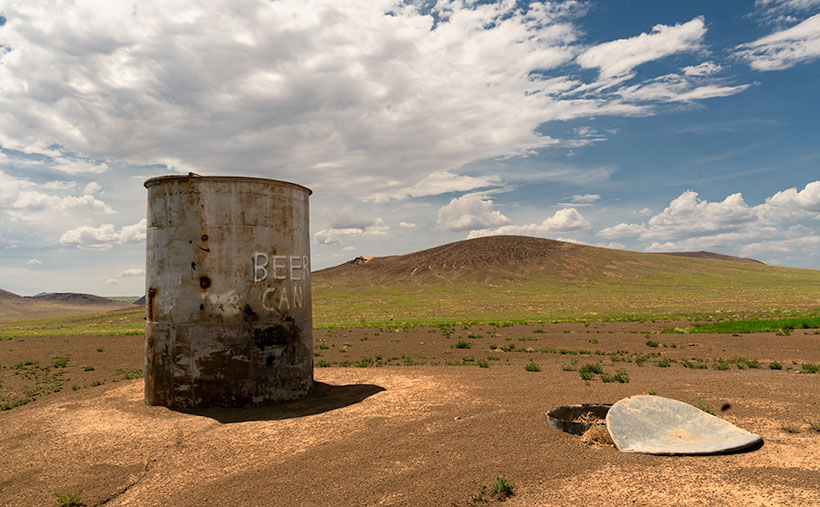
Maybe one of the reasons the lava field doesn’t get more visitors is that much of it is on private land and doesn’t get much press. C. J. Babbitt is credited for the mountain’s name. If you’re young and ambitious, you can climb to the rim, and from that point of view, the crater resembles an overflowing chamber pot—or Shit Pot as he called them (and you thought those pretty flowered bowls and matching pitchers you see in museums was for washing your face). When the cartographers heard what the locals called the crater, they said, “Oh dear. We can’t put that on the maps. We’ll just use the initials.” If you’d like to see the view from the top without leaving your Lazy-Boy, I captured this Google Earth view.

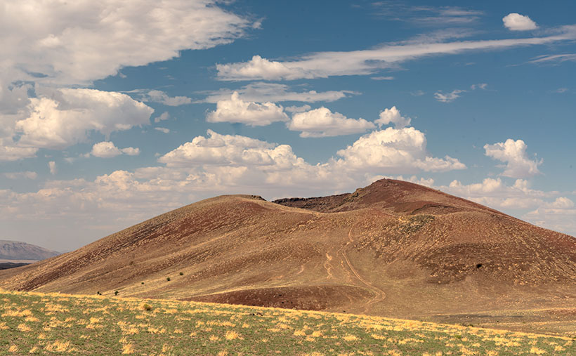
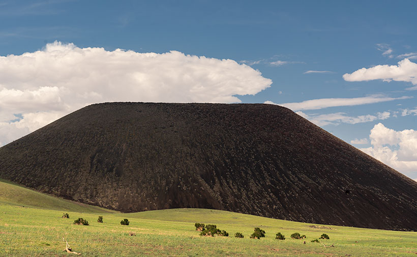
When we drove out to the lava field, I wanted to video the cinder cone. Most of the time we spent at S.P. Crater was with the drone, and I didn’t get a still shot that I liked (if you’re interested in seeing the videos, here’s the Pond5 link). As we started to leave, I stopped to shoot last week’s photo of Split Top, and when I turned back, I saw this image of S.P. Mountain. The clouds were casting shadows on the cone, but a break in them let sunlight spill down on the grass and juniper trees. I’m pleased about how well this photo turned out. It’s only a couple of zebras short of being from an exotic African location. Naturally, I called this image S.P. Mountain because I didn’t want the Internet censors after me.

You can see a larger version of S.P. Mountain on its Webpage by clicking here. Come back next week when we finish our tour of the San Francisco Lava Field with one last photo. We’ll see you then.

Till next time
Jw

BTW:

I’m working on my Website’s Arizona galleries to make them flow better. Unlike the other State groupings, I have too many shots from Arizona to have a single page. So, I have subcategories for deserts, farms, towns, mountains, etc. This week I posted a second Arizona Index page that allows visitors to switch between a slideshow view and a thumbnail view with a button click. Some people like the traditional thumbnail view, while others prefer to see slides. Here’s the link to the page. What do you think?

Split Top Picture of the Week

Split Top--An unnamed cinder cone in the San Francisco Lava Field that looks like a scored loaf of bread when viewed from space.
Split Top–An unnamed cinder cone in the San Francisco Lava Field looks like a scored loaf of bread when viewed from space.

(Note: I sent out a copy of this post earlier this morning, but I don’t think your copy was emailed (at least, I never got a copy in my inbox). I’m resending today’s post to make sure you get your money’s worth. If this is a second copy for you, please forgive me.)

When I was half my current age, and between wives, I didn’t need anyone’s permission to take a road trip. I’d close the blinds, lock the front door, and disappear for a couple of days whenever I had the urge—and an extra $20 for a tank of gas. Like the time, my friend Russ (of ‘Russ-Bus’ fame) and I drove to Lee’s Ferry for a weekend of fishing.

I don’t recall why we got a late start, but it was probably because he had to work on Friday and close up his shop. I guaranteed our room and told the innkeeper that we’d arrive late. She said she would leave a key for us, so there wasn’t a pressure to get there at a specific time. After he showed up at my apartment, we loaded his equipment into one of my $500 wonder wagons and headed north to Flagstaff, where we stopped for gas and a burger.

It was dark and cold when we piled back in the car. Still, at least the car heater worked, so we were cozy as we continued north on U.S. 89. As we started down the long grade north of town, we chattered like a couple of school girls about family, customers, fishing, and photography—the usual guy stuff. About halfway down the hill, I began to have trouble seeing the road, so I asked Russ if the headlights seemed dim.

“Well, we could always drive without them,” he quipped.

“Have you ever done that?” As I asked the question, I reached down and switched the lights off and counted—one thousand one, one thousand two. In that short amount of time, everything outside went topsy-turvy. The countless stars gave the sky a milky white glow, and everything below the horizon was a black hole. We couldn’t see the highway lines, much less the pavement.

Russ screamed and shouted, “DON’T DO THAT,” so I turned the lights back on.

As we drove on, I realized we were running on the battery, and it was getting critically low. The headlights were dim, but no idiot lights glowed on the dash. I wondered if we could make the gas station at Cameron twenty miles away. We swapped ideas and decided to try coasting as much as we could. There was no other traffic, and if we could keep up a minimum speed, maybe we could reach help. I let the Chevy roll to a crawl, fire it up for speed, and coast again. We got through three cycles before the battery was drained completely. Ahead, I saw a single light on at Hank’s Trading Post, so I coasted into the lot and stopped beneath it.

We popped the hood and wiggled a couple of things, poked at something else, looked under a lid, and kicked one of the front tires—all of the things men do when they’re stuck. I slammed the hood and looked around. All we had was the empty highway and an old telephone booth. Both options seemed useless since neither of us had any change in our pockets.

With no other choices, I tried a Hail-Mary pass. I went to the booth, pushed the door open, stepped inside, lifted the handset, and pushed the ‘O’ button. An angel’s voice said, “Operator.”

“Hello. I’m stranded on the highway, and I need to call a tow truck and charge the call to my home phone.”

She politely explained why she couldn’t do that but offered to stay on the line and get help for us. She dialed a few numbers without success, but on the third try, a man answered, “Cecil’s garage.” I think I forced our predicament out of my mouth with one breath.

“I’ll be there shortly,” he reassured.

I started to hang up, but the operator’s voice interrupted, “Don’t hang up. I’ll stay on the line until he arrives.” I thought it could take an hour, but Cecile pulled up ten minutes later. I thanked our operator about a thousand times before saying goodbye.

Cecil only took moments to determine that we needed to drag the old Bel Air wagon back to his shop. Once there, he put a charger on the battery and poked around in the engine compartment. “This is the wrong alternator belt,” he said, pointing to the culprit. I don’t remember if it wasn’t the right length or width, but it wasn’t making complete contact with the pulleys. He quickly took the old one off and held it against the row of dust-covered belts lining the upper wall. After finding one he liked, he pulled it down and muttered, “This one should work.”

After Cecil installed the new belt, I started the car, and it ran like a champ. Even the headlights were bright again. “You should be good to go. It’s charging, so the hour drive to Marble Canyon will fully charge the battery,” with that, he handed me a shocking bill. Before he could change his mind, I wrote him a check for the $15.00 he charged us for the belt.

That’s my most memorable U.S. 89 story, and it explains why I wave and give Cecil a shout-out each time I drive past his shop. You’re asking how does this story relate to this month’s project? Well, you turn onto S.P. Mountain Road—the road out to the lava fields— on the south side of  Hank’s Trading Post. “It’s a small world after all . . .” (Stop. There’ll be no singing dolls in my post).

I took this week’s picture just a short jaunt down S.P. Mountain Road; it’s the first cinder cone along the dirt road. In my search, I didn’t find a name for this peak, but when I viewed it on Google Earth, it looked like a rustic bread loaf where the baker scores the top before putting it into the oven. That’s why I called this week’s picture Split Top.

You can see a larger version of Split Top on its Webpage by clicking here. Come back next week when we continue on the dirt road to another volcanic cone that does have a name and an amusing story. We’ll see you then.

Till next time
Jw

BTW:

Over the past couple of weeks, I built and published a page to make it easier for new people to subscribe to my journal—a subscription page. I think it came out terrific. To protect new subscribers, the system sends an email to confirm that they want to sign up, so you can’t just willy-nilly add strangers to the list. So, if you know someone that would enjoy seeing new pictures and reading my musings, don’t be stingy and share me with your friends and family. Who knows, they may be just as crazy as we are.

Beer Can Picture of the Week

Beer Can - An uncouth visitor left an empty beer can near a cattle tank on the Babbitt Ranch.
Beer Can – An uncouth visitor left an empty beer can near a cattle tank on the Babbitt Ranch in Northern Arizona.

If you drive north on US Route 89 from Flagstaff, you get to see one of the best scenic views in the country. To get there, we need to get around the San Francisco Peaks—the remains of an ancient volcano, and they rise over 12,000 feet—Arizona’s high point. Route 89 is on the east flank of the peaks and winds through Flagstaff suburbs that suffered fire and flood damage this spring. As the road climbs a gentle grade, the scenery changes from open meadows full of new homes to a ponderosa forest. There was substantial fire scaring, but many tall, red-barked trees survived.

At the top of the hill, the four-lane highway briefly flattens before you reach the Sunset Crater National Monument entrance road and the 7288-foot elevation marker. A mile further, the road suddenly drops from its mountain elevation to the Little Colorado River Bridge, 3100 feet below and 35 miles away. On an exceptionally clear day, you can see into Utah—I swear.

This vista encompasses every rainbow color. On the left, the dark green pine trees grow down the mountain slope until they make way for lighter green junipers and then the yellow grass-covered cinder cones on the Babbitt Cattle Ranch. The twenty-one miles of perfectly straight blacktop divides the east side from the west. On the east side, patches of black lava flow give way to the distant Painted Desert colored in hues of reds, whites, greys, and purples. Above everything, the deepest blue skies—a color they don’t make anymore—tie the canvas together.

Every time I see this scene through my windshield, I have a smile on my face. My joy is probably because I’m on my way to someplace fun, like Lake Powell, Lee’s Ferry, the Grand Canyon, or (shudder) Utah. As I drive down the mountainside, I habitually switch my dash view to see if I can recover my gas mileage before I hit the bridge. It keeps my mind occupied for the next half hour. As you all know, I’m easily amused.

Except for a few visits to Sunset Crater and Wupatki National Monuments, I’m usually passing through this wonderland. But, during our July visit to Flagstaff, Queen Anne and I came to the mountain’s north side to photograph the cinder cones in the San Francisco Lava Field. They’re technically on the private ranch owned by the Babbitt family. The Arizona pioneers that have been successful ranchers, merchants, and politicians.

Before we drove out to the ranch, I checked in at their store in town to see if we needed a hall pass. “No, if the gate is open, you can enter as long as you’re respectful and drive on the roads.” Taking the caution to heart, I was surprised when we reached the old trading post that there wasn’t even a gate to open. The dirt road was so smooth that we didn’t tax our Jeep’s capabilities—not even its four-wheel drive. It’s only a couple of miles to the lava field, but before we got there, we drove by a cattle tank where some uncouth slob left an old beer can. I was so upset that I stopped to document what the thoughtless cretin had done. The picture came out so well that I made it this week’s featured image. I call it Beer Can.

As you might have figured out already, it’s not actually a beer can but graffiti that some vandal painted on the side of one of the ranch’s metal water tanks. They’re used to hold water for the cattle during the dry season. Indeed, the lettering is still vandalism, but one that appeals to my perverted sense of humor. Besides the tank, I don’t know what the trash can lid is. Perhaps it’s a cache to store surplus hay for when a herd is in the area.

An unnamed volcanic cone appears in the background, and it doesn’t seem very high until you try climbing it. Neither Anne nor I tried scaling anything on this trip because there weren’t any stairs for me to bitch about, so as usual, Anne stayed in the Jeep reading her Kindle while I ran around taking pictures.

You can view my Web version of Beer Can on its page by clicking here. We have a month’s worth of photos from the lava field, so we’ll be spending October here. I hope you enjoy this week’s pictures and come back next week when we present more. Be sure to join us then.

Till next time
Jw

BTW:

We recently discussed making a Route 66 photo trip and producing a large coffee-table book from the new photos. After burning down my calculator, we’ve put off any such trip until later. We’ll wait and see what happens next year.

Hotel Monte Vista Picture of the Week

Hotel Monte Vista - Built in the 1920s as an upscale hotel by Flagstaff investors. It was named the Community Hotel until a private corporation purchased it in 1960.
Hotel Monte Vista – Built in the 1920s as an upscale hotel by Flagstaff investors. It was named the Community Hotel until a private corporation purchased it in 1960.

The proverbial railroad tracks split Flagstaff’s downtown, but in this case, I don’t think there’s a wrong side. The north side is a historic district; on the other side, old warehouses fill the limited space between the tracks and Northern Arizona University. Each has a distinct vibe.

Older masonry structures make up the historic district and crowd the sidewalks. As a result, the streets are narrow, and parking is limited. If you find a parking spot, walking about the 24 blocks downtown is easy. When the founders laid out the town, they included alleys so deliveries and utilities would be off the street. That may have worked in the mid-twentieth century, but retail space is at a premium, so landlords split the buildings, and now shops occupy the building’s front and back. That means there’s always a beer delivery truck clogging the street somewhere.

I get the feeling that since the city is Arizona’s “premier” ski area, the city planners are using other resort towns as models. There is the usual mix of restaurants, bars, souvenir shops, and galleries for you to spend money in. The building owners maintain the facades well and have decorated them with low-voltage lights—for that Disney Main Street look. However, something’s missing. The Snow Bowl doesn’t draw the same skiers as Aspen, Telluride, or Park City (the airport couldn’t hold that many private jets). So, although I enjoy walking around and seeing the architecture of the old town, it needs more polish.

Nope - I spotted this sign in a tavern window and it confused me for days. Then I realized that it has a different meaning if you move the 'N' from the top, to the bottom.
Nope – I spotted this sign in a tavern window, which confused me for days. Then I realized it has a different meaning if you move the ‘N’ from the top to the bottom.

If the area north of the tracks is all façade, the south side is another story. As you’d expect from a college town, it’s more bohemian, rustic, and organic. The merchants may slap paint on their industrial buildings and hang an open sign on this side of town. They depend on the product and repeat clientele to survive. You’ll get the same bar food but without the pretentiousness. For example, this is where the youth hostel is. Over the past two weeks, I’ve shown motel signs from here, where you’ll find a café called the Tourist Home. This eating establishment has good food, but they’ve replaced the wait staff and cashier with your cell phone—petulant geezers like me, beware (they dare to expect tips).

For this week’s picture, we will cross the tracks north to the Aspen and San Francisco Streets intersection. Here, we’ll see Flagstaff’s third oversized sign on scaffolding. This one is on the roof of the Hotel Monte Vista, one of the oldest hotels in Northern Arizona.

Monte Vista has an interesting backstory. It was built in the 1920s with money raised by local citizens. Including a big chunk from Zane Grey, they raised $200,000 to fund an upscale hotel the town desperately needed. It opened on New Year’s Day 1927 as the Community Hotel. It was a publicly held business until private investors bought it in 1960. Besides the hotel, the building was home to the Post Office, newspaper, and radio station, and its lounge was a speak-easy during prohibition. The hotel’s Website has a page with other histories, famous guests, and ghost stories. You can read it here.

I shot this week’s image, Hotel Monte Vista, early morning before the sun and the empty streets. The lack of light muted the building’s colors. It looks like I was trying for a sepia-toned effect, but I wasn’t. It’s an unusual look, and I’m not sure it works. What do you think? I also noticed that the signs on all three of this month’s photos have the sign on the right. I would have changed that had I thought about a grouping layout.Teal 356 - I stumbled on this Porsche while on my morning shoot on the south side of the tracks. It proves that even the bourgeoisie appreciate classy cars.

Teal 356 – I stumbled on this Porsche while on my morning shoot on the south side of the tracks. It proves that even the bourgeoisie appreciate classy cars. You can view my Hotel Monte Vista web version on its page by clicking here. I hope you enjoy seeing this month’s trio of hotel signs. Next week, we start a new adventure from Northern Arizona, so be sure to join us.


Till next time
jw

BTW: A couple of weeks ago, I wrote about coffee cups, contests, and calendars. I asked for your advice, and the response I got was: <crickets> – – Silence – – </crickets>. You’re not interested, so to paraphrase Seinfeld’s soup-Nazi character, “NO CUPS FOR YOU—ONE YEAR.” Now, I must shave my head before meeting with Larry and Mo.

Motel Downtowner Picture of the Week

Motel Downtowner - The 1930's sign was built on a tower to lure tourists off of Route 66.
Motel Downtowner – Nackard built the 1930’s sign on a tower to lure tourists off Route 66.

Tourism is Flagstaff’s biggest money maker. According to one ASU study that I found, tourism accounts for 84% of the town’s employment. Some of our non-Zonie friends may wonder what’s the attraction; after all, most out-of-state people don’t know much about our state and can only name two Arizona cities. Every season has a reason to visit the town at the bottom of the mountains. As I said at the beginning of this project, its 6,909-foot elevation (1,600 feet higher than Denver), mild weather is an excuse we valley lowlifes to visit and escape the heat. Fall ushers in colorful aspen trees that the annual fires haven’t burnt—both of them. Then in winter, some people like to strap planks to their feet and slide down the big hill outback of town. Finally, everybody goes to Flagstaff to toast marshmallows during the spring fires.

In the above list, I didn’t mention the daily traffic on Beal’s Road—Route 66—now Interstate 40. It’s an excellent place to stop for a meal or to get some sleep. And—oh yeah, I forgot—it’s how you get to the Grand Canyon.

It’s no wonder overnight lodging shaped and dominated Flagstaff architecture—from abandoned stone ruins to tacky Route 66 motels to today’s boring corporate three-story shoeboxes lining I-40. I think it’s understandable but sad that, as highways evolve, the old buildings and signs are disappearing. I get a big grin when I see one standing and add it to my collection. It must be the same thrill a hunter gets when shooting a Moose, Elk, or Kiwanis.

Apartment House - I shot this down the street from the Downtowner sign. I'm positive that if my wife ever set foot in this building, it would rip a hole in the space-time continuum.
Apartment House – I shot this down the street from the Downtowner sign. I’m positive that if my wife ever set foot in this building, it would rip a hole in the space-time continuum.

Last week, I wrote about Du Beau’s novelty concept—lodging catering to the motor car traveler. His motel was the second of its kind in the country—the first was in San Louis Obispo, California (that one burnt down, which makes Du Beau’s the oldest survivor). The buildings in this week’s image are ten years older but were initially used for other purposes. According to one account, it was a brothel. How scandalous. There were whore houses in the west—who knew? It wasn’t until the 1930s that K. J. Nackard bought the place and turned it into a motel. At the time of its opening, the main road through town was on the south side of the tracks. Later, the highway department realigned Route 66 to the north side. That’s when the sign wars began.

If you’re fishing for customers and they drive by your door, you can hook customers on a bamboo pole, but when the traffic is on the far side of the train station, it’s time to break out the surfcasting tackle. Both motels began building bigger and brighter signs to lure travelers to the Bohemian side of Flagstaff. These signs make today’s city planners shudder.

I took this week’s photo that I call Motel Downtowner with the rising sun. I had been walking around town in the twilight, and the tower was one of the last places I shot. It was after 7:00 by then, and I needed a cup of coffee (Macy’s European Coffeehouse—he’s also a fellow photographer). I have tried to get a shot of this tower for years, but I’ve never been happy with my results.

Ford GT40 - Evidently, not all residents at the Motel Downtowner are lowlifes. I found this car parked in the motel's portico, and is rare, even for Route 66.
Ford GT40 – Evidently, not all residents at the Motel Downtowner are lowlifes. I found this car parked at the motel’s entrance ten years ago, and it is rare, even for Route 66.

You’ll notice that the characters are angled so that they’re readable while driving the Mother Road, and that angle points to Route 66. The motel is no longer open. Another type of business has taken over the buildings, but the sign remains; somebody in Flagstaff appreciates good kitsch and history as much as I do.

You can view my Motel Downtowner web version on its page by clicking here. Next week, we have another historic Flagstaff hotel sign to show, so be sure to join us then.

Till next time
Jw

BTW:

Oh, you’re still here even though the show is over. You must read to the article’s end. Good on you, mate. You’re probably wondering what’s down here in the basement. This is my new ongoing section with announcements, follow-ups, answers, etc. I intend it to be a paragraph long (my fingers are numb) so I don’t have to clutter your inbox with extra mailings. I hope you find it helpful.

Motel Du Beau Picture of the Week

Motel Du Beau - This 1929 establishment was one of the first to cater to tourists driving those new-fangled motor carriages.
Motel Du Beau – This 1929 establishment was one of the first to cater to tourists driving those new-fangled motor carriages.

When Queen Anne and I spent a week in Flagstaff last month, our primary goal was heat relief, but I was confident that I could snap a few shots of historic buildings and signs to add to my Route 66 collection. In this journal, I’ve written several times about my experiences traveling the Mother Road as a kid, so I’ll spare you from repeating them. Instead, I must say that I was disappointed at how hard it was to find kitschy motel and dinner signs along the main street. More profitable strip malls and professional offices are rapidly replacing them. Interstate 40 travelers prefer the newer hotels on Butler Street, where the Little America Hotel is. Nobody drives 66 anymore—too many lights and too much traffic.

John Steinbeck’s novel The Grapes of Wrath, the depressing story of dust bowl migrants, searching for survival, didn’t make Route 66 famous. Nor did that fame come from my father’s generation, who—like the Joad family—moved en masse to California after World War II. It came when Angel Delgadillo—the Seligman barber—pitched a historic highway idea to the State of Arizona. When that designation came through, tons of beer-guts had a play-pen to gather and drive their car toys. We’re dying off now, and like the coals in your Webber Grill, that passion is dying with us.

Master photographers Ansel Adam and Minor White influenced how I photograph the world. Still, in 1975, the George Eastman House showed a photo exhibition called The New Topographics: Photographs of a Man-Altered Landscape. The show still floats between museums today. It was a collection of ten photographs made by ten photographers that were opposite the landscapes I embraced. It was heresy. The photos are stark images of industrial buildings and houses devoid of people. I didn’t even think some of the artists printed very well. But I did kind of like the ones John Schott did. His pictures were of Route 66 motels. You can see where this led.

Flagstaff Train Depot - Either this is new or I've been blind, but the coolest Route 66 sign that I saw was the train station's address.
Flagstaff Train Depot – Either this is new, or I’ve been blind, but the coolest Route 66 sign I saw was the train station’s address.

I’ve considered compiling a book of my Route 66 photos. I have several, but most are from Arizona, with a couple from California and New Mexico, but nothing east of Texas. If this horse hadn’t been flogged to death, I still could work on my own Mother Road project. Now that I’m retired, I have time. I figure a month on the road should do it. To do it properly, I’d have to drive a classic car—something from the ’50s or ’60s. However, it needs air-conditioning, cruise control, and a good stereo (I won’t put up with AM radio stations dropping out under bridges). My ultimate ride would be a red ’62 Corvette—like the one Buzz and Todd drove—but hold the whitewalls. I could haul my camera equipment behind it in a small aluminum trailer like the autocross guys lug their race tires. October is a perfect month for a road trip, so if anyone out there wants to be my Angel investor, let me know. You’d get all the bills, half of the proceed, and a free book out of the deal.

This week’s featured image is of a prominent Flagstaff landmark. It’s called Motel du Beau, and the subject is the sign. It’s one of three hotel signs towering above the city (can you guess what this month’s project is). With the Lowell Observatory on top of the hill, Flagstaff has adopted a dark-sky policy, so the zoning people would never allow these enormous signs in town. If they weren’t historical landmarks, the city would tear them down.

In the late 1920s, Albert Eugene Du Beau vacationed in northern Arizona and envisioned a new way to make money. Instead of building a multi-story building for railroad and train travelers to stay, why not create a place for people traveling in these new-fangled motor cars? So, he designed and built a single-story motor-hotel (later shortened to motel) to be convenient to unload and load their vehicles in 1929. His design featured a U-shaped layout with steam-heated garages (they burned down in a 1970s fire) and indoor toilets. He built his motor court adjacent to downtown’s main street, which was brilliant because, in time, the busy highway became Route 66. The Motel Du Beau was one of the pioneering businesses to use neon signs and elevate them on towers.

In today’s modern world, the Motel Du Beau still looks like a nice place to stay, with rooms starting at $75—a far cry from the original price of $2.50 per night. Their website shows various room types, and they have a lovely little wine lounge called Nomads. I’d certainly be willing to try it after they reopen the bar.

I hope you enjoy seeing a part of Flagstaff’s history. You can view my Motel Du Beau web version on its page by clicking here. Next week, we’ll look at another historic Flagstaff motel sign, so be sure to join us then.

Till next time
jw

Blackout Why there's no picture this week

I consider weekends my workweek, and my routines are as regular as clockwork. Fridays, I record two albums from my collection so that I can listen to them in my car (we have terrible radio stations in Phoenix). On Saturday, I decide whether the oldest photo on my New Work webpage is worth moving into another gallery or getting rid of; then, I layout and upload the new Picture of the Week. On Sunday, I’m ready to crank out my weekly article. After I publish it, I’m free to spend the rest of the week as I wish.

It happened on Friday. I had finished my first album and was putting it into its jacket when boom (actually, it was silent, but I like making noises), the room went dark. There was a monsoon rain outside, but it wasn’t particularly violent. We sometimes get power outages that last an hour or less, so I was sure I’d finish the second record soon. I went out on the porch to enjoy the rain. The damp air was cool on my face as I sat down and drank my soda.

When the second hour passed, I opened the house to the cooler outside air. But the air was so still that none of it slipped past the screens. Finally, Queen Anne came home from her girl’s night out (she does that to avoid my music). She tried twice in the dark to find a parking spot, but she gave up when she backed into the garage door (why doesn’t my remote work). We talked about how the night had gone for another hour before going to bed in the dark. At least the temperature was pleasant, even if it was humid.

After an uncomfortable and restless night, we woke to her phone’s messaging buzz. The community gossip line was in full swing. “Did anyone else lose power?” “When will it be back on?” Finally, there was some positive information, “APS estimates it will be noon before the power’s back.”

I looked at Anne and said, “Come on, let’s go to Denney’s for breakfast.” There was nothing we could do without electricity, so we had time to kill. It turns out to be more than true. Next, the gossip line spits more bad news, “The wind took down 15 poles along US 93.” The bad part of the storm that we didn’t get had a micro-burst and snapped 14 wooden poles like a match. The newly installed metal one couldn’t carry the weight and folded like a straw. How was Arizona Public Service going to clean that up by noon?

There were lines outside the Wickenburg restaurants, so we decided to go to the Denny’s in town. Since we had time, we could stop a Lowes and Harbor Freight after breakfast. We spent a couple of hours buying air filters and looking at tools, generators, and battery-operated fans before the drive home. As we drove, the gossip machine spits out more realistic news, “APS says it may take three or four days to restore power.”

I sweat like a pig even when I think about being hot, so Anne and I swapped ideas of what to do. It’s Labor Day weekend, and people are crowding the roads. We checked Prescott Hotel prices, and even the Motel 6 was north of a hundred bucks. Who can we stay with? As we rounded the big bend in Wickenburg, I remembered that Aztec RV Park was on the south side, so I swerved across the yellow lines and two lanes of traffic into their driveway. When we stopped at the office, I was surprised that they had a space open that we could have for four days. I whipped out my credit card so hard that you thought I was striking a match. What great Samaritans these people are.

We then got home with four bags of ice and repacked the fridge and freezer to save as much food as possible. Then we filled our camping cooler with food and ice and loaded the little refrigerator in the Casita with as much food, drinks, and medicine as it would hold before we set off to our refugee camp and wait out the siege. Even though the outside temperature was only 105°, the first thing we did was to plug in power and turn the AC to South Pole.

After we splurged for a night-on-the-town Burger King meal, we returned to The Ritz for an evening in the trailer—under the bridge—down by the river. Camping is fun for us, but usually, we’re on a photo shoot away from home. It’s an adventure. We sit outside and relish the experience. On the other hand, sleeping in a cramped trailer just to get through the night 10 miles from my comfortable bed was not fun. The gossip machine groaned in the background, “APS has four crews on this outage and may have it fixed in a couple of days.” I fell asleep despite the air conditioner’s constant drone.

I woke this morning at dawn and began rousting Anne from her slumber. We needed to get home and check the ice in the fridge. As she got up, she was interrupted by the gossip machine, “The power’s back on. APS managed to route one line past the damaged area. The power came back on at 10 (pm).” I told Anne, “Oh jeez, we can go home and see if it’s true. Check-out isn’t until 11:00, and the office doesn’t open until 10. Let’s see if it’s true and come back for the trailer.” That’s what we did, and when we walked into the house, the temperature was perfect, my staging lights were still on, and the turntable was still spinning in the corner.

After unpacking the boxes, and the cooler and moving food around, we headed back to Wickenburg to fetch The Ritz. Since we didn’t set up the whole camp, it only took minutes to pack and hook up. On our way out, I stopped at the office to see if they’d be open to a refund. As you’d expect, the answer was no, “You made a reservation, and we require thirty days’ notice for a refund.” What great Samaritans these people are.

Till next time
jw