Lightner Creek Fire

It was the Wednesday before July 4th and the Lightner Creek Campground and Cabins staff were making preparations for the busy weekend when our friends and fellow camp hosts – Tony and Amelia – raced into the park. This was unusual because the speed limit is 5 mph and camp hosts try to enforce it. They had just come back from town and breathlessly told us that there was a house on fire just east of the campgrounds. We all rushed up the park’s hill to gawk.

It was the house of our, shall we say, interesting neighbor. She lives there with her kids and they regularly shoot off fireworks and guns. On Memorial Day there were loud gun shots coming from there well into the night which made the campground guests nervous. Someone called the sheriff, but the shots stopped before they got there. One of her other neighbors said there were three loud explosions before the house caught fire. The house was burning very quickly and the color of the flames suggested that a gas fueled the flames. Rumors in the community said that she grew pot and processed something more potent in a back room, but we never verified any of that.

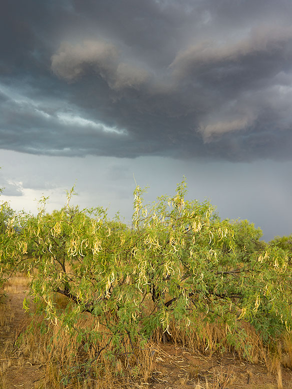
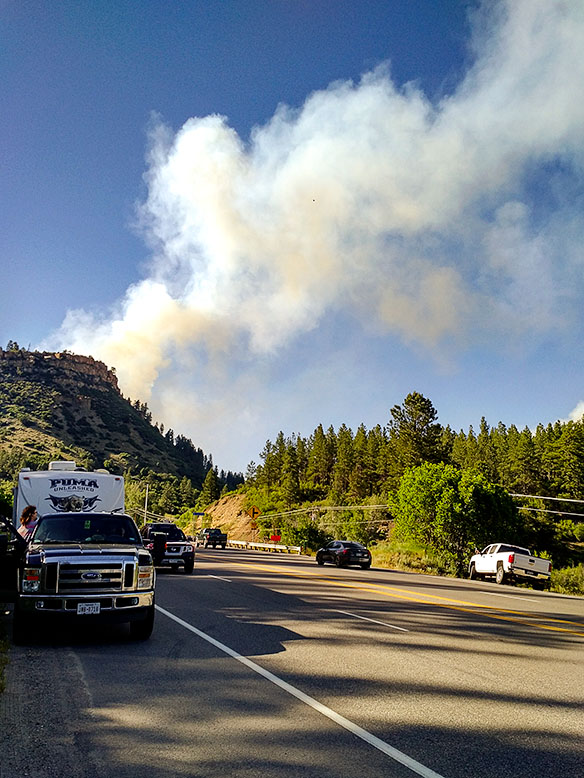
As we stood on the hill, we watched the fully engulfed house, when suddenly the fire jumped to the trees and started up the mountain. We all started panicking and using a lot of four letter words. Thank God the wind was blowing away from us.

Amelia – a 911 dispatcher in a previous life – asked if there was an evacuation plan. Robert and Andrea, the owners, fetched ours from office and contacted its creator – the original owner who lives alone at the campground’s west end. She came over, very upset and helped coördinate the evacuation. The plan broke the campgrounds into sections. The owners assigned camp hosts different sections and sent them to their assigned area with instructions for how each campsite should exit. We told everyone to “prepare to evacuate”. It couldn’t have been more than 15 minutes when we got a “MANDATORY EVACUATION” from Code Red – a must have cell phone app. No matter where you are in the USA, it will send you emergency alerts for your area. When the alert sounded, the camp hosts spread out to their assigned areas and began evacuating the campers. Several people were in Durango then, but we made sure anyone in the campgrounds knew they had to leave. After we got the guests out, Deb and I started to hook up our trailer, but before we could, a sheriff showed up in front of our rig and said we had to leave; NOW! So we started throwing stuff in the truck and car and abandoned the trailer. I had time to put in the awnings and turn off the propane, but that was it. A personal evacuation plan for our RV is on my to-do list from now on.

The fire quickly spread after jumping the road. Fortunately, the wind kept it away from the campgrounds.

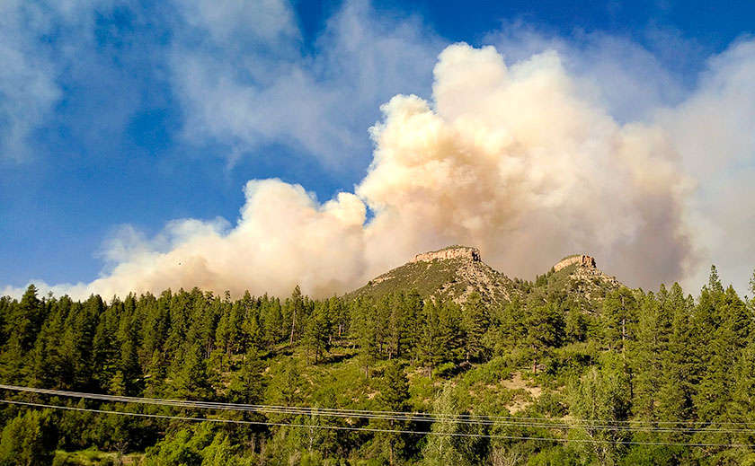
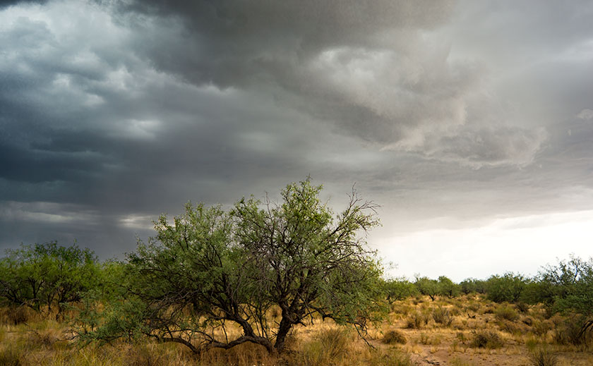
The campground is in a box canyon and the only way out was down the road toward the fire. The wind was blowing the fire away from us, but it had jumped the road and started up Perins Peak to the north.  The fire had jumped across high enough that the road was not blocked. We drove through a maze of fire trucks but finally made it to Hwy 160. We assembled on the side of the highway and wondered what to do. We could see the smoke billowing out of the canyon and flames crawling up Perins Peak. We didn’t know if we would have anything to return to, but we got everyone out safely.

At The Rendevouz
After getting out of the canyon, we gathered at the sided of the road to ponder what to do next.

One of the guests in the group got word that the Red Cross was at the La Plata County Fairgrounds setting up an evacuation center. A seasoned camp host knew where it was, so most of us followed him. Wouldn’t you know it, the fairgrounds booked a rodeo for the holiday and the parking lot was full. Trailers and motorhomes were redirected to the high school parking lot next door. The next day the shelter moved to the Escalante Middle School which had a big parking lot for rigs. The Rocky Mountain Team Black Hotshot fire fighters moved into the fairground shelter. By the way, the Red Cross was great! They provided a place to sleep, water, snacks, and food – donated by various town restaurants.

Deb and I opted for a hotel room instead of trying to sleep in a dormitory full of kids, dogs, and people. When I got on the phone I found out that most of the hotels were booked for the big weekend. I finally found a room at the Holiday Inn, and we spent two nights there until they let us go retrieve our trailer. One at a time, a sheriff escorted the camp hosts in to hook up trailers then get out. The fire was only 20% contained so planes were flying over us while helicopters picked up water from trout ponds close to the road. Some idiot was flying a drone in restricted air space and delayed air operations a day (he was later found and he’s facing charges).

Lightner Creek Fire Damage
This is the ridge that the fire went up when it first started. The wind blew it over to the other side. This ridge goes right up behind the campground. The burn line runs along the ridge line and the only campground exit was down the canyon and past the fire.

It was a relief pulling our rig out of the park. We headed straight for the middle school parking lot where we dry camped for two nights. The Red Cross commandeered the dining room and they organized a big meeting on the fire’s fourth day with all the players; fire fighters, police, sheriffs, etc. who gave us the status of the fire. Denver TV stations filmed the meeting and we made the evening news. They told us that the fire was still only 20% contained, but they were letting some homeowners return to their homes. Since we were not home owners but were permanent summer residents, officials excepted the camp hosts and they issued us special Rapid Access ID cards. The next day they let us go back to the campgrounds. Whoopee! The road was still closed to the public and we couldn’t take any guests yet, but we were back in our summer home.

Fire Damage
This is where the fire started and continued over the top of the ridge toward Hwy 160. You can see how close the fire came to the campgrounds.

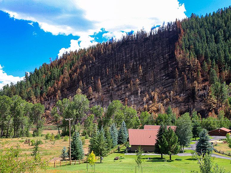
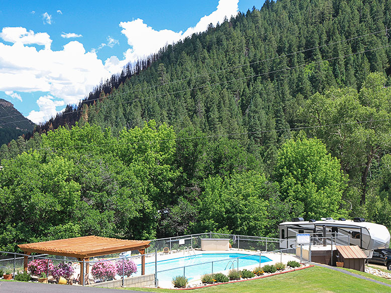
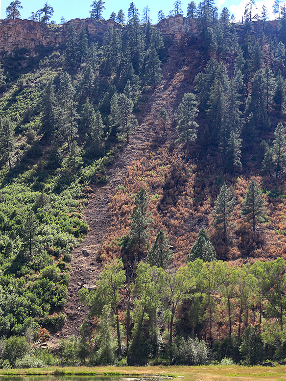
Since we had the campgrounds to ourselves, we threw a 4th of July Bar-B-Que. The campground wasn’t burned at all, and the facilities were fine. The fire came closer than we thought, but it did not cross the boundary. We were very lucky. There were a lot of cancellations for the 4th of July week, but we are now back up to full capacity and it is still a great place to spend the summer.

Fire Break
The morning we got our trailer out there was a line of fire fighters walking in single file to cut that fire line.

They have not identified the reason the house caught on fire, but it was very suspicious. Since the house was destroyed and the fire was so hot, the fire investigators couldn’t find the fire’s cause. As for our interesting neighbor … she wasn’t at home when the fire started, but she did check into the evacuation shelter, so she’s homeless but otherwise ok.

Fred Poteet

The Face of Mother Earth in a Sand Pile

As I wrote earlier this week, we’ve had a pretty good Monsoon Season. The afternoon storms have brought rain every other day. A couple of the storms were short but intense causing a lot of run-offs. The amount of rain is too much for the soil to absorb and so, most of it runs into the street. If the flow is great enough, it will drag sand off the lots on to the street.

On our morning walks around the trailer park, Queen Anne and I come across these sand trails all the time. One of them, however, stopped me in my tracks. I saw something that I recognized and as we examined it, we realized it was a pretty good map of the North American Continent. Alaska, Canada, Greenland, Cuba, and Mexico were all in their places. Missing in the map was Florida, some of the Aleutian Islands and parts of the east coast. With climate change and all, maybe it’s a sign of things to come.

A map of North America in sand run-off
A pretty good map of North America that we found in sand run-off while on our morning walk.

What do you think?

Till then … jw

ps: After three storm cells move through the area last evening, it washed more, sand onto the street. On this morning’s walk, the shape was completely different. Only the Alaska part remained recognizable.

Photobooks

I enjoy a fine photographic print as much as anyone but in all my years, I have only ever paid for one photo print — Jody Forster’s gorgeous print of the east wall of Shiprock — taken by another photographer. Sure, artists gave me a few prints over the years (including several from Jim) and I have traded prints with a handful of photographers whose paths I’ve crossed. I have also purchased a small number of platinum/palladium contact prints on eBay for no more than $25 each.  I don’t count those because the prices I paid for them effectively round to zero.

Knowing all this, it probably will not shock you when I say that it’s my belief that, in today’s art market, individually produced photographic prints generally cost too much and deliver too little in terms of value. And I say that despite having sold more than 50 prints of my photos through several galleries over the years. Unfortunately, the math just doesn’t work for me.  As much as I enjoy viewing and collecting the work of other photographers, which is a lot, the fact is that I am just not willing to pay the prices that most photographers ask for their prints. Which isn’t to suggest they’re not worth those prices, of course, only that they’re not worth those prices to me.

Fortunately, there is another way to view and collect the work of many photographers besides buying prints.  It’s a better, more cost-effective way that is potentially even more artistically successful too. I believe that photography books (or ‘Photobooks’ as they’ve become known in some online photographic circles) are a better option than individual photographic prints and very much the way of the future.  At least for serious photography, that is, because we all know the way of the future for general photography is to view photos as jpegs on a computer monitor or Smartphone screen and skip printing them on paper entirely.

Photobook Collection
A small sample of my photobook collection.

In fact, I’m so convinced that I’m correct about this that I’ve voted with my wallet and purchased several hundred photobooks over the past decade, averaging roughly one book a week over the last few years that my finances allowed me to actively collect them. Mind you, it wasn’t always this way for me.

When I was just getting started with photography in the mid-70s and continuing through last decade, I didn’t pay much attention to photobooks, because I generally found the image quality reproduced there abysmal compared to a proper photographic print, made using wet chemicals in a dark room. This was especially true of the handful of books that contained color photos, which were then still a new medium in the fine-art photography world.

However, this started to change for me around the end of the last millennium, when my parents gave me a signed copy of Christopher Burkett’s Intimations of Paradise as a 40th birthday present. Burkett’s landscape photography was sublime, as was the photo quality reproduced in his book.  Surely much of the credit for this belongs to Burkett himself: after all, he had worked for many years as a press operator before becoming a professional landscape photographer, during which time he surely learned a thing or two about how to reproduce photos well using the offset printing process. But regardless of where the magic in his photos originated, the results were visually stunning and very much a revelation to me. That’s because, until that moment, I didn’t know that photos printed in a photobook — and color ones, at that — could look so good!

Inside the Covers
One of my photobook collection showing the layout of story and images.

Of course, by then, I already knew that photos printed using paper and ink instead of paper and gelatin could look great because I had made them myself at home from my medium, and large-format film transparencies for a few years.  Between the prints I was making myself and those I had started buying buy off the shelf (in the form of photobooks), I quickly came to realize that photographic prints made digitally using paper and ink were the future … well, my future at any rate, where traditional prints were clearly doomed to become the past, and very quickly so at that.

More than 15 years have passed since my eyes were first opened and not surprisingly, what I believed true then is proving even truer today, as the two technologies (inkjet printing and book publishing) have moved-in together and are now happily cohabitating. While photobooks printed on a sheet-fed, offset press still have an edge over those printed on demand using a large-scale, high-volume, inkjet printer, the small differences between them matter only to those who have a very discerning eye or photographers who make their own prints and are picky about such things, such as Jim and me.

These days, the quality of a well-printed photobook is quite remarkable and their prices — even the expensive ones — are actually quite reasonable when you divide the cost of a book by the number of photos that in it.  The typical $50 photobook has at least 50 photos (and often multiples of that) so the cost per photo is almost always a buck or less. And many (most?) photobooks can be purchased new for less than $50, which makes them even more of a bargain.  At the other end of the scale, I have also purchased used photobooks for as little as 25 cents at garage sales and thrift stores, which makes the cost per image infinitesimally small. Tell me: When was the last time you saw an art gallery selling photographic prints for a buck apiece (or for that matter, even 50 bucks)?

The large number of photos contained in a typical photobook leads me to my next point, which is that most photobooks are projects, where the photographer presents many photos of and on a subject, then careful and thoughtful sequencing tells the viewer a story visually, or a visual story (which isn’t the same thing). When this is done well, the result is absolutely fascinating and far more so than is possible with just a single photo.

Although many photographers also use photobooks the way that musicians use “greatest hits” albums (i.e., collect their most successful/popular works from across their career into an easy to sell, easy to digest package) and there’s absolutely nothing wrong with that. The most successful books, artistically speaking if not also financially for the book’s publisher, are monographs that focus on a single topic. In my experience, there are very, very few single photos that are fully self-contained and able to tell a complete and compelling story without some added context, be it in the form of a written caption, an accompanying narrative text, or more supporting photos.

Collecting photobooks instead of individual prints has allowed me to broaden my photographic horizons and knowledge by a large margin, as well as affordably explore the work of emerging photographers and established photographers who are working in genres that are quite far afield from the type of photography I do myself. When they’re done well, photobooks are like mini-exhibitions. But instead of me having to go to a gallery across town or a museum across the country to see them, the mailman conveniently brings them to me!  I mean, how great is that?!

If I have somehow managed to piqué your interest (it’s always possible, right?), but you don’t know where to start, might I suggest one or both of Jim’s photobooks?  There’s a link to them somewhere on this page and as I own copies of both (bought with my money, in fact!), I can recommend them enthusiastically. Another source I use for new photobooks is the daily email I get from the Photo-Eye Gallery/Bookstore in Santa Fé. It features several photobooks each day. Better still, it offers a sample tour of most of the books featured, so it’s a quick and easy way to familiarize one’s self with both new and old photobooks. The sign-up page for it is here: http://www.photoeye.com/EmailNewsletter/index.cfm .

Happy hunting … JG

Check out Jeffrey’s photoblog here – Ed.

Lunch on the Front Porch

It’s raining this morning, a steady gentle shower that’s driven the outside temperature down to 73°. That’s the lowest reading I’ve seen on our outside thermometer all month. The rain postponed our morning walk until it let up. We made it through most of our route before Queen Anne felt a couple of drops and began screeching, “I’m melting.” By the time we made it back to the house, the point on her black hat flopped over into her face. I’m afraid that she looked like a bit of a cartoon.

It’s been a decent monsoon season so far. We’re getting rain every other day. There’s enough to fill Lake What-A-Muck-A until the waters lap onto the pavers out back. The ground is damp, the saguaros have plumped again and some of the cacti have begun to bloom for the second time.

There’s enough moisture coming up from Mexico that the thunderheads form over the plateau behind the Weaver Range each afternoon. We watch them as they boil in slow motion until they anvil out and spread in their direction of travel. As the hot air rises down here on the desert basin, it acts like a vacuum, sucking the thunderstorms off of the mountain. Here at the house, with our views to the horizon, we watch as the lightning and rain cells pass to the north and south of us. But sometimes, we’re in the path. It’s like playing dodgeball while standing still.

Thunderhead Over the Weaver Range
Each afternoon, thunderheads form above the plateau behind the Weaver Range.

First, come the outflow winds which can gust over 60 mph. That’s why we keep the tree out front trimmed up, so the wind can blow through the top canopy instead of breaking off limbs or blowing the tree over. In the neighborhood, we’ve had nearly a half-dozen century agaves bloom, with a 20-30 foot phallic center shoot. The Christmas tree like stalk gives the wind enough leverage to rip the roots of the four-foot blue agaves right out of the ground.

Skull Valley Monsoon
Monsoon clouds move down from the Bradshaw Range in Skull Valley.

Following the wind is rain. Sometimes it’s only a drop or two that leave spots on your dust-covered car. Other times it’s a gully washer and the streets fill like rivers. Out on the desert floor, the washes run with fast-flowing muddy red water; those are the flash floods that are dangerous even if your miles downstream. Every once in a great while, Mexico sends up enough moisture that you get a long-lasting gentle rain, like today. It’s slow enough that the ground has time to absorb it.

Mesquite Pods
Ripe pods on a mesquite tree will be dispersed in the winds of a monsoon storm.

Conveniently, the rains usually arrive in time for sunset cocktails, and we sit out on one of the covered porches while enjoying a glass of wine. It’s a popular summer past time in Arizona. The temperature drops 10 to 20 degrees below the century mark. The lightning show is always spectacular and can last for hours. With a stiff breeze and the moisture; it’s pleasant outside, besides you have to hold down the furniture somehow.

Mesquite and Monsoon
A mesquite grove is about to get drenched in an afternoon thunderstorm.

It ends abruptly. Shortly after the rain stops, the sweltering black top evaporates the last of the street’s water like hot sauna rocks. The wind dies and the humidity closes in. When it becomes intolerable, you retreat back into the air conditioning, if the power’s still on. There’s time for a TV show before watching the weather. It’s important to find out how the rest of the valley fared before calling it a night.

Till then … jw

Hikography

Hi, I’m Jeff, another one of Jim’s long-time friends. Jim recently invited me, along with his other friends to write a guest post for his blog. I presume he thought his friends would jump at the chance to give to his blog and like Tom Sawyer, his friends would paint his fence. I was onto him though and intended to politely decline, because I find writing too much work and I have done quite enough of that for now, thank you. But as I was drafting my response to his email, my fingers somehow typed the words “Sure … it sounds like fun” and now I’m stuck. I hate when that happens.  There is no pain worse than self-inflicted pain!

Because I didn’t have any ideas what I might write about, I subsequently asked Jim if he had any particular topics in mind.  Unfortunately, he wasn’t very helpful, suggesting only that I should write about something that’s related to travel or photography, even if only minimally. Oh, and if possible, I should try to make it humorous, too.

Well … okay then.

Unfortunately, my past and present family circumstances have been/are such that I’m not able to travel very often nor very far these days. Instead I wind up photographing my dog, Miss Abby, while we’re out walking. I have a photoblog where I post the resulting photos: https://abby.aminus3.com/. The only photography I do nowadays is typically done late at night while I’m walking around well-to-do Scottsdale neighborhoods with Miss Abby in tow or in the seedy, grimy downtown Phoenix warehouse district.

While I’m not able to travel as often or as far as I would prefer, I do still enjoy getting away from it all when I can, even if only to a small and very temporary degree, and the very best way I’ve found to do that is to take a hike … literally. Fortunately, I live in the geographic center of Scottsdale, which means there are two hiking areas within a 10-minute drive from my house and three more within 20-minutes, all of which are part of the McDowell Sonoran Conservancy project (https://www.mcdowellsonoran.org/).

Thompson Peak
The broadcast towers visible on top of Thompson Peak are the only clue that one isn’t in a pristine wilderness.

At each of these hiking areas, I can hike for several miles without backtracking over the same trail and better still, once I’ve hiked 15 minutes or so away from the trail head, it’s surprisingly difficult to tell that I’m on the outskirts of the fifth largest metropolitan area in the U.S. instead of way out in the remote desert, miles from anywhere (The only thing that occasionally ruins the illusion is the broadcast towers visible on top of some of the nearby mountains). The time commitment is small; two to three hours, max, round-trip from my front door. These trips require minimal planning, so I can usually be out the door and on my way within 10 minutes of when the urge to get away hits me.

The McDowell Mountains
Within 10 minutes drive from my home, I can immerse myself into nature.

While I’m not much of a landscape photographer these days, I always bring a camera with me and practice what I have come to call “hikography,” which means taking photos while I’m hiking, sometimes even one-handed and without breaking my stride.  It’s roughly similar to  “street photography” (walking around with a camera and recording scenes of everyday life), except that in the desert, there are no streets, only trails … and a lot fewer people.

Share the Road
Like Street Photography, you can capture shots of other travelers along the trail.

To my way of thinking, hikography is different from other genres of photography, because hiking is the primary activity and photography is strictly secondary.  This means that I leave my tripod home, as well as the extra lenses and filters and other accouterments that are part and parcel of the landscape photography experience, and instead carry a simple, point-and-shoot-type camera in my right hand, secured by a wrist-strap and always powered-on, so it’s immediately ready for use.

Sagauro
There is always time along the trail to stop and take shots of the giant icons of the Sonoran Desert.

For me, the key to hikography is that it’s not purely photography nor purely hiking, but a complementary combination of the two.  Without taking photos along the way, I find hiking pointless and boring; and without hiking, I find landscape photography ho-hum (which is almost, but not quite boring) and largely a waste of time due to the all the standing around and waiting on the ‘magic’ light.

But combine the two and something magical happens, just as when peanut butter and chocolate combine to make Reese’s Peanut Butter Cups.  When done together, the two activities, hiking and photography, create a greater, more enjoyable experience than either of them one does when practiced individually. Hiking now has a purpose, a raison d’être, if you will, and photography becomes a tangible experience, not just an intellectual search for pretty scenes to put in front of a camera when there’s good light available. The two activities build upon each other, the way that fine wine complements fine food and a cigarette after sex used to hit the spot.  Just ask the Queen … er, never mind.

So now I have a reason to hike regularly, as well as a reason to take photos while I’m doing so.  By engaging in both activities simultaneously, I am now actually engaging in both activities, instead of just thinking about doing them … tomorrow … maybe. Did I mention the fitness benefits of hiking?  They are real and if it’s done often and energetically enough, hiking can replace a significant amount of time spent in the gym (Unless your gym is amply stocked with attractive, toned women wearing Lycra and Spandex and doing pole aerobics [or, I suppose, depending upon one’s orientation, hunky men pumping iron], this is a good thing. Alas, my gym is not one of those, because it recently closed and I now use the free gym at the nearby Scottsdale Senior Center, which is very aptly named.  Needless to say, given my options, I would much rather spend my time hiking in the desert than working out at the gym.)

By now, you’re no doubt thinking, Well, … this is all well and good for him, but I don’t live in the desert with many hiking areas nearby and I’m not very good at using a camera, either, so what good does any of this do me? To my way of thinking, the answer to that question is crystal clear: Just as New York is said to be a state of mind, so is landscape photography. Landscape photography — literally, photographing the land, doesn’t mean just photographing grand vistas at a National Park or the Grand Canyon. It can also be done (in fact, it should be done!) close to home as well and not just during the two weeks of the year when you are vacationing somewhere scenic.

No matter where you live, there are many places nearby where you can hike and photograph the land.  It may not be the pristine, natural land untouched by man that you want to experience, but just as with sex and pizza, even the worst you’ve ever had is still pretty damned good! While there’s nothing wrong with appreciating the work of others (or buying many large prints to hang on your walls … hint, hint), there’s also nothing like creating art of your own. Even if the only camera you own doubles as a telephone and video arcade, it can still be used to take (nay, to make) great photos, so long as you point it at an interesting scene instead of at yourself (Just say No to selfies … puh-leeze!).

No matter where you live, there is somewhere nearby that you can explore, both on foot and with a camera. Now you have two reasons instead of just one to push your chair back from your computer, lace up your comfy shoes, and head out the door with your camera in hand. You may well come home empty-handed. Hey, it happens. At least you will have gotten outdoors for a while and had yourself an experience, and possibly even a bit of an adventure.

JG

Check out Jeffrey’s Photoblog – ED.

El Gato Azul

There are a lot of things we’re thankful for when we moved to Congress last year, but shopping isn’t one of them. Sure we have a couple of local grocery stores and merchants nearby that we make do for basics, and there’s always Amazon for the occasional weird stuff we need, but making a Costco run takes days of planning. The stores are far enough away that we plan our trip into town with multiple stops along the route. Shopping at the big box store is an all-day trip.

Our house is conveniently (if you can call it that) located midway between the two nearest stores. We exclude the one in Sun City because it’s impossible to maneuver around the golf carts and inattentive drivers. Our choice is between the Deer Valley store on I-17 and the one in Prescott. The drive time difference is literally five minutes, so the choice comes down to what other errands we need to run. If I need to pick up some hardwood, we go to Deer Valley. If I need something at Harbor Freight, we head to Prescott (for our friends out-of-state, the townspeople pronounce it ‘Press-kit’ and they’re not shy about correcting you). During the summer though, Prescott wins hands down because it’s in the pines and cooler.

When we make the Prescott run, Queen Anne and I try hard to build in time for lunch, and our favorite place there has become El Gato Azul a tapas place at 316 West Goodwin Street. Goodwin is the street that runs along the south side of the courthouse; the restaurant is two blocks east of Whiskey Row.

El Gato Azul Restaurant
Two blocks east of Whisky Row is the tapas bar, El Gato Azul.

The restaurant building is a small one story box on the east side of the Willow Creek trail. It’s smaller than most fast food chains, and the Dijon mustard colored façade has lavender ledges covered with potted plants and lights. The clutter almost obscures the sign.

To enter, you step down from the sidewalk (an access ramp is a few steps to the right) and walk through the bright blue door. Inside the dining room are two . . . maybe three tables and behind the hostess station, an ‘L’ shaped bar fills the rest of the room. The décor is a mix of upscale Goodwill and early garage sale interspersed with canvases from local artists. If you’ve come to eat, (why else would you be there) the host/hostess will escort you back outside through a door on the right. Here is a large covered main dining area that is open in summer, but enclosed with clear vinyl curtains in winter; portable heaters provide warmth.

The food that we expect at El Gato is not what you’d call rib sticking comfort food, but small dishes as you would find in a Spanish tapas bar, but with a southwest influence. It’s more of a tasting menu where you get an interesting burst of flavor combinations in one bite. As with a Chinese restaurant, it’s fun to pick out several items and share. One dish is not enough for a full meal, but the Queen and I fill up by sharing three items. It’s sort of like making a dinner out of a couple of appetizers. Plates range in price from $10-$13 each, so it’s not cheap. They offer a list of soft drinks along with the stocked bar.

Cajun Corn Dogs
One of the meals we enjoyed was their Cajun Corn Dogs. This consists of bacon wrapped tiger prawn fried in corn batter and a glaze of honey.

The next time you travel up Prescott way and you want to try something different, the Queen and I recommend you give El Gato Azul a try. We recommend it, even though Anne is now annoyed with me for letting The Blue Cat out of the bag.

Till then . . . jw

Mesa Verde National Park

After blowing all our money last year on the Alaska trip, Deb and I thought we were doomed to learning new survival skills for staying all summer in hot Arizona. Then our neighbor, Tom Beavert saved us. He spent his last five summers in cool Durango, Colorado and told us about jobs as camp hosts at the Lightner Creek Campground, so we checked in to it, and got the jobs.

We arrived in the middle of May, just in time for a little snow storm. This was a pleasant surprise after leaving AZ where it was already getting into the 90s. The campground is in a box canyon at 7000 feet elevation. That means the mornings are always cool (40s) and the afternoons are not that bad either (70s or 80s). We work 3 days on and 3 days off, so we have plenty sight-seeing time. It’s really nice staying here for the summer.

Google Map Durango Area
The map shows the highway between Durango, Colorado and Mesa Verde National Park.

Our first outing was to Mesa Verde National Park, about 35 miles west of Durango. We wanted to visit it before the hot summer set it. When we were dating, Deb and I had stayed in Cortez, CO and had stopped at the park, but only briefly. Hmm . . . I guess we had other things on our mind back then. This time as an old married couple, we saw everything. We spent 4 days in the park and took all the tours. There are a few self-guided tours and plenty of to do on your own, but the best ruins are only accessible via $5.00 guided tours, and because the tours fill quickly, you need to sign up early.

Cliff Palace
Cliff Palace, the crown jewel of Mesa Verde National Park and an architectural masterpiece by any standard, Cliff Palace is the largest cliff dwelling in North America.

Chapin Mesa is the main visitor center. It’s here you’ll find The Archaeological Museum, Cliff Palace (the largest cliff dwelling), Spruce Tree House, and Balcony House. The tours of Cliff Palace and Balcony House are a must. Balcony House is the most challenging tour. It starts with a climb up a 32 ft. ladder and ends with a crawl through a 12 ft. tunnel on your hands and knees. Believe me; it’s worth it. Allow a day to take both of these tours.

Long House
Long House, about equal in size to Cliff Palace, fills an expansive 298-foot-long sandstone alcove from end to end. The village includes about 150 rooms, 21 kivas, and a row of upper storage rooms.

Wetherill Mesa is the “quieter side” of Mesa Verde. It offers a number of opportunities, depending on the season. Mesa Verde is one of the few National Parks that allow bicycling, and on Wetherill Mesa there is a 5 mile loop built for a shuttle bus. The bus was discontinued, so now you can walk or ride your bike on a nice paved road. Wetherill Mesa was my favorite because it was less crowded and had one of the best tours.

Square Tower House
Square Tower House, a beautiful cliff dwelling built-in an alcove in the upper walls of Navajo Canyon. The “tower” had windows, doorways, and flooring, and the inner walls were plastered. About 60 of the original 80 rooms remain.

The Longhouse (the second largest cliff dwelling) tour takes 2 hours and you really get to explore all of it. Step House and Badger House are self-guided tours and you can ride your bike through the Badger House Community Trail. Allow one to two days to see everything on Wetherill Mesa.

Long House
Long House, a well-preserved four-story triangular tower rises from floor to ceiling at the far west end of the alcove.

Here is a tip for grabbing a good lunch. Far View Terrace is a nice cafeteria with a gift shop run by the Ute Indians. Their prices are good and the gift shop has a better choice than the Visitor Center. The only other place to eat on Chapin Mesa is Spruce Tree Terrace, near the museum. They are both good, but Far View Terrace is much larger and quieter. We had a wonderful Navajo Taco. If you are going to Wetherill Mesa, they only have a snack bar and a covered patio where you can eat your own lunch.

Far View
Far View was a popular place in the early days at Mesa Verde. From A.D. 900 to about 1300, it was one of the most densely populated parts of the mesa. Far View House in the background and Pipe Shrine House were part of the Far View Community.

Don’t forget to pickup the Amateur Photographer’s Guide at the Visitors Center. It is just one sheet, but it has some pretty good advice. It identifies the most photographed areas, the light at different times of day, and suggested locations for shooting. You need a telephoto lens for some overlook locations, but don’t wait for sundown to shoot from the overlooks. The best time is from 5:00 to 6:30 pm to get the most light on the cliff dwellings. Note that high contrast will overexpose parts of your picture and underexpose others. It is best to zoom in on either a dark or light area.

Petroglyph Point
Petroglyph Point Trail, An ancient loop trail starting at the Chapin Mesa Archaeological Museum leads to a petroglyph panel and through scenic wildlife habitat. Hikers must register at the trailhead or museum. The trail is physically challenging and is steep and uneven, with steps, cliff edges and tight passages, and includes strenuousness elevation changes.

We really enjoyed Mesa Verde and now it’s time to move on to our next adventure. We will be exploring downtown Durango and its surrounding area.

Fred