Sun Showers Picture of the Week

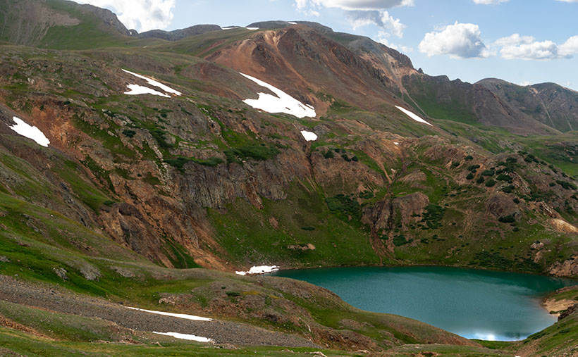
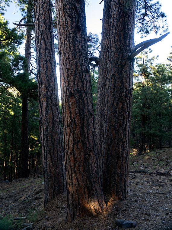
The day was getting late, and before Fred and I could go back, we needed to find one final pass to cross and return to Silverton—and eventually Durango. When we stopped to enjoy Lake Como—last week’s photo—it turns out that we were already near Hurricane Pass. Unlike the other passes, we didn’t have to crawl down one mountainside and up another. Instead, the road followed the ridgeline for a half-mile, and voila.

Unfortunately, Hurricane Pass wasn’t as photogenic as the others that day. The road simply turned east for a bit before disappearing down a crack. Of course, the crack opened into a gulch, then a river valley as we descended 5,000 feet into civilization. It was an anticlimactic way to end the day. The trail was soon gravel followed quickly by asphalt; with guardrails, of all things.

Sun Showers - Although small clouds filled the sky, the only rain we got was a sun-shower.
Sun Showers – Although small clouds filled the sky, the only rain we got was a sun-shower.

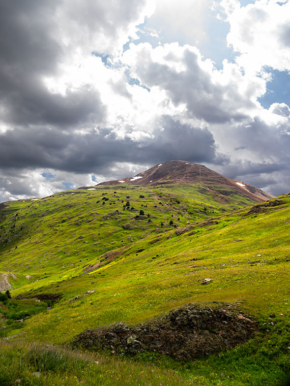
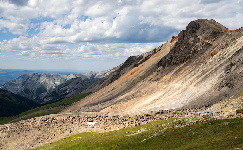
But don’t worry, I come bearing gifts. All during our outing, puffy little clouds filled the sky. They seemed to bump into one another like the balls on a billiard table. Then they would part again leaving large patches of blue sky. On our way down the hill, it started to rain—while the sun was shining. As we rounded a bend in the road, the sun appeared in one of those patches and backlit the mountainside. It’s one of those moments where the grass becomes iridescent and glows. I’ve seen this before in New Zealand. I failed to capture it there, but I think this week’s image is close. I call it Sun Showers. The mountain that we’re looking up as maybe Hurricane Peak, but I’m not sure. In case you’re wondering—yes, those are the Sun’s rays at the top. Did I tell you about the steep angles we experienced during this trip?

You can see a larger version of Sun Showers on its Web Page by clicking here. Be sure to come back next week when I’ll show you my favorite image from our adventure exploring Colorado’s San Juan Mountains in Fred’s Toyota—oh, sorry—Fred’s Jeep.

Until next time — jw

Lake Como Picture of the Week

Lake Como as seen from the top of Calaifornia Pass.Lake Como – A little alpine lake from California Pass in Colorado’s San Juan Mountains.

Something is intoxicating about standing on a mountaintop. You get a sense of accomplishment—an incredible buzz—while taking in the view. As you spot familiar landmarks, the map you carry around in your mind gets updated. I can understand the addition mountain climbers have to the highest peaks. I’m just too lazy to be one of them, and you won’t catch me on the climbing wall at the local gym—or inside the gym in the first place. Spending a day with Fred driving his FJ up-high passes in the San Juan Mountains was good enough for me.

When we decided not to spend all day driving Colorado’s Alpine Loop but drove up two of its passes, we wanted another challenge. The first ascent was scary, while the second was not so much. I felt like a kid on a swing urging his parents to push harder. “Again,” I shouted. So, we stood on Engineer Pass with the map spread over the hood, looking for another route back to Silverton. After all, we didn’t want to go back down the way we came. That was along the Animas River and was flat and dull. We agreed on a route that would take us over two more passes before dropping back to Silverton via Cement Creek, and that meant that we’d have first to drive back down to Animas Forks.

From the ghost town, we headed west up California Gulch. Going in this direction, the road ran straight ahead for several miles and appeared to end midway up California Mountain. Several times, I’ve traveled roads without a clue what’s ahead. For example, Interstate 15 is heading north out of Mesquite, Nevada. As it leads for the Beaver Mountains, you can’t pick out where the freeway climbs over them. I always involuntarily back out of the gas in case the road suddenly ends—like against the mountainside. At the very last moment, the Virgin River Gorge opens and swallows the highway. I was getting that feeling now.

It wasn’t until the perceived end of the road that it turned on itself and climbed behind a side ridge that hid the route from below, and as we drove around the bend, the trail went vertical. I questioned our decision to go this way because this was undoubtedly the beginning of the roller coaster from hell. Fred managed to keep all four wheels on the ground while his truck grunted its way up the grade. When we reached the top, as with the other passes, there was a spot to park and look around. When I got out, I decided a box of Depends would be a handy accouterment on these trips.

But the view! The light was coming in, and there were great shots back at California Gulch, and in front was this pretty little alpine lake—Lake Como—on the other side. I have seen pictures of places like these in magazines, but I’ve never been to one. It was breathtaking—well, 13,000 feet is stunning enough, but you know what I mean. I snapped several variations of this photo, and we eventually drove down to the lake where Fred tried to park over an open mine shaft, but that’s another story. This week’s featured image is the version I liked best because of its composition and color details. I call it Lake Como. I hope you like it.

Don’t let your eyes miss out—feast them on an even grander version of Lake Como right here (Jim’s Page)! Buckle up because we’re diving back into Colorado’s enigmatic San Juan Mountains aboard Fred’s Toyota next week. Trust me, you won’t want to miss this!

Until next time — jw

Engineer Pass Picture of the Week

When my friend Fred planned our off-road excursions through the San Juan Mountains, his initial itinerary was to complete the Alpine Loop, which includes two passes, circling Red Cloud Peak, Sunshine Peak (which are two of Colorado’s 14,000 foot mountains, but aren’t even in the top 10), and a stop in Lake City. Now that I’ve had time to recover and look at my maps, I think that would be a fabulous trip, especially if we did it later this month when the aspens turn color. But, when we stopped at the Silverton information center, he was told that it’s a seven-hour trip, and it was already afternoon, so we decided to sample some of the passes around Animas Forks instead.

Last week’s image was from Cinnamon Pass, and this week’s picture is from Engineer Pass—our second stop. Both of these places are along the Alpine Loop. If you do Cinnamon first, the route will be counter-clockwise and the opposite direction if you first go over Engineering Pass. The two passes are only miles apart, and most of the Alpine Loop is east of them. Although they’re relatively close, as the crow flies, driving the road requires descending 3,000 feet to the ghost town then 3,000 feet back up the other way. If I thought going up the mountain was exciting, going down was harrowing. I almost got out and walked.

Mountain Man Fred
Mountain Man Fred – It’s not an illusion that Fred’s hanging on to that wire. The sign is well over the slope, and the footing is unsure because of the loose shale.

As we rounded a corner, we saw a knoll where several vehicles were parked, and a crowd snapping selfies and taking in the view. We assumed this was it. It wasn’t. It was Odom Point, and we joined the others for the view and document our visit. As we returned to the road, a sign that said that our pass was further down the road, so we drove another couple hundred yards.

Engineer Pass
Engineer Pass – Looking north from the saddle, you can see two mule trails blazed by prospectors. One leads down into the valley while the other zig-zags up the unnamed peak.

This week’s image that I call Engineer Pass was taken from the 12,800-foot high mountain saddle looking north, and it shows an unnamed peak that’s another hundred feet higher. Also visible are two mule trails, one that descends into the valley and the other that cuts across the talus slope past the red streaks before a switchback as it zig-zags to the summit. I declined to try either of the trails.

While we were taking in the view, I turned around and was stunned to spot over a dozen cyclists peddling up the grade from Palmetto Gulch. No way! We were driving a jeep, and I was out of breath, while these guys were racing mountain bikes on the same road. It’s no wonder that Stephan Pastis ridicules bicyclists in his syndicated cartoon Pearls Before Swine. They’re insane.

You can see a larger version Engineer Pass on its Web Page by clicking here. Be sure to come back next week when we’ll continue exploring Colorado’s San Juan Mountains in Fred’s Toyota.

Until next time — jw

Hualapai Road Picture of the Week

To reiterate what I said in my first post on exploring the Hualapai Mountains, there isn’t much open space there. The little village consists of a cluster of homes, a general store, and the county park for everyone else. There aren’t the amenities that you expect in Flagstaff or the White Mountain communities, but if you like camping and a challenging day hike, the park at the top of Sawmill Canyon Road is a different destination.

Hualapai Road
Hualapai Road-A dirt trail on top of the Hualapai Mountains that reminded me of the Loan Ranger’s opening scenes.

When I first arrived, I explored every road to see what’s there, but the only trail leading out of town soon became to rough and exceeded my road rules, so I turned around and headed back to the park. Before I did, I liked the rustic feeling of the country road, so I composed this week’s featured photo of the scene. I call this image Hualapai Road, although it’s little more than a trail.

The reason that I selected this photo over some others was how the trail curves over a hill between the rocks and trees. It makes me wonder where it leads, and what will I see when I get there. The countryside also reminds me of the opening scene of the old TV show The Lone Ranger that I used to watch as a kid on Saturday mornings. It’s easy for me to imagine the masked hero galloping on his white stallion over the hill—kind of like me and Archie.

You can see a larger version Hualapai Road on its Web Page by clicking here. Be sure to come back next week when we start another series of image from another location.

Until next time — jw

Four Ponderosa Picture of the Week

When an Arizonan talks about a pine tree, the red barked ponderosa is most likely what they’re referencing. It’s the common pine tree in Arizona. We have so many of them that our grove grows like a slash across the state’s middle, like a belt, and they continue east into New Mexico. It’s the world’s longest contiguous ponderosa forest in the U.S. Sadly, some of our brightest citizens try to burn them all down each fire season.

It’s a happy tree for me because it means that I’m in the high country when they’re around. Most likely, I’ve traveled to escape the desert heat and spend some time in the shade of the tall pines napping with a bit of fishing line tied around my toe. I have a fond memory of getting up early on a fall morning to drive up to Hawley Lake, and as the sun came up, we were on the Rim Road. The morning sunlight flickered between the tall trees, and I felt like I was driving through the Black Forest in Germany. Although I’ve driven that road hundreds of times since then, I’ve never had the same feeling.

Four Ponderosa
Four Ponderosa – Growing in a grouping that reminded me of a four-poster bed. Maybe I thought that after my long hike and I was tired (and don’t forget, tired).

During my visit to the Hualapai Range outside of Kingman, I was surprised to see ponderosa growing. In the Desert Southwest, they only grow at higher elevations. On the road, I rely on the trees to estimate my height. First, come the pinion pine at around 5,500’, then the ponderosa starts at 6,500’, and then the aspen show up at over 7,500’. The mountain island on top of the Hualapai’s probably is most likely the western edge of our grove. Only the Black Mountains are west of here, and they’re not high enough to support the big trees.

I walked by the ponderosa’s in this weeks image on my way back to Archie after a hike up the mountain. My legs were already sore, and this four-tree grouping reminded me of a four-poster bed. The spacing between them was ideal for hanging a hammock. It’s a good thing I don’t carry one because I would have spent the night, or even worse, I would have rolled over and fallen out onto the ground. That would be just my luck.

I call this week’s image Four Ponderosa, and you can see a larger version of it on its Web Page by clicking here. Be sure to come back next week when we show another photograph from the Hualapai Mountains.

Until next time — jw