Red Canyon 2018 Utah Photo Shoot

Mother Nature is ruthless. It’s not that she has a vendetta against humans, after all, we’re natural too. We have a place in her scheme of things, but to her, we’re just ants on her sidewalk and stepping—or not stepping—on us doesn’t cross her mind. She has more important things to worry about. It’s our job to stay out of her way.

Gnome Garden
Gnome Garden – Red Canyon has spires, hoodoos, and ridges like Bryce Canyon, but the sandstone is redder and the site is not as extensive. It’s the first and a worthy stop when traveling Utah’s SR 12.

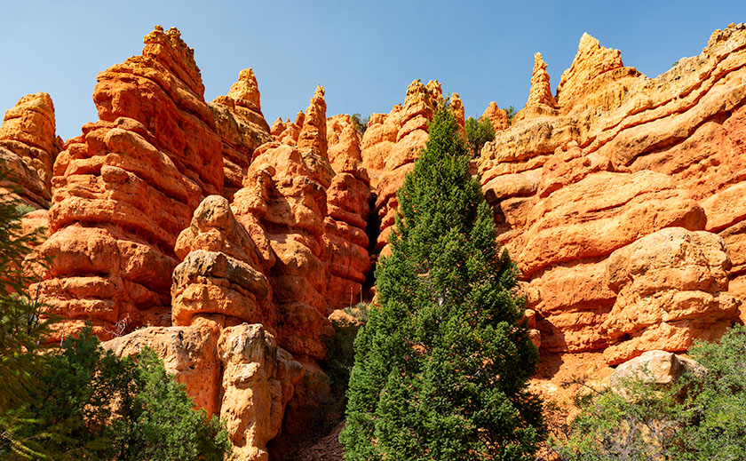
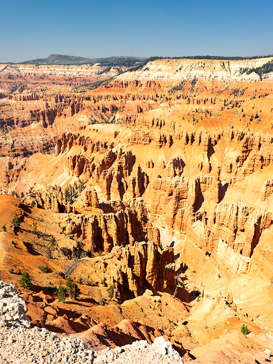
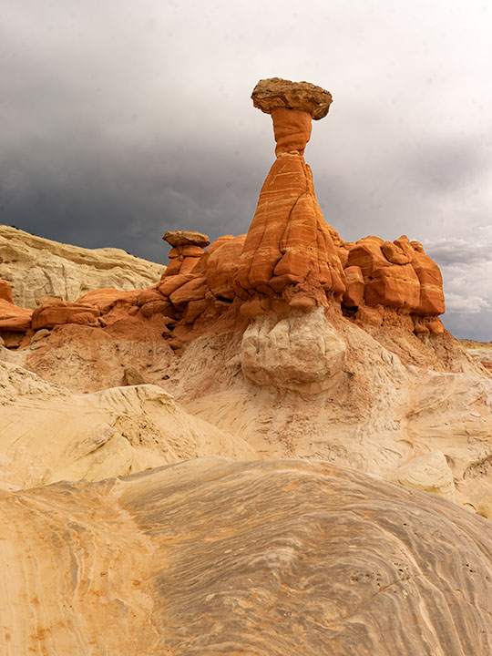
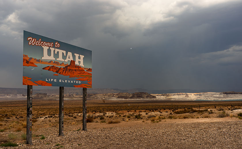
For the last couple of days we’ve hiked in Red Canyon—the first natural feature you pass when traveling east on Utah’s State Route 12. Red Canyon isn’t an official national or state park, but because it’s in the Dixie National Forest, the Department of Agriculture maintains a visitor center there. It’s Bryce Canyon’s foyer. The rocks are slightly redder and tourists traveling to Bryce stop to gawk and take pictures. When they built the road, the crews drilled two tunnels through the sandstone cliffs and that’s another cool thing about the canyon.

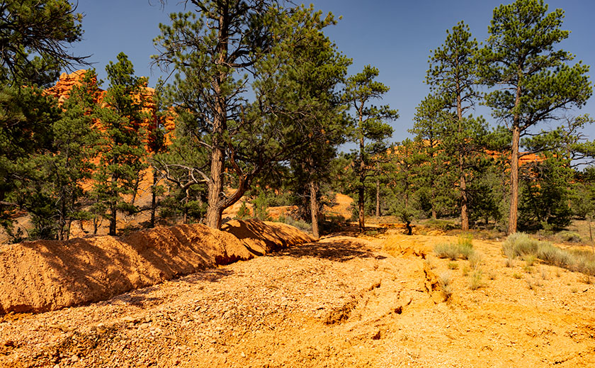
The Forest Service also maintains trails that wander through the pinnacles, and on our visit, Anne and I stopped at the center to select a trail that was suitable for a couple of old codgers. “Oh the trails have all been wiped out by the big thunderstorm we had last week,” the ranger told us. Well … she wasn’t really a ranger, but she had a yellow uniform on and sat behind the information counter. The storm that she referred to dumped 1.75 inches in 20 minutes resulting in flash floods that ripped up the parking lot, bike path, and some of the road. The rushing water threatened to damage the visitor center and restrooms but didn’t. When we drove in, the parking lot was stained red from the mud that a Bobcat scraped off, so we knew we missed the big mess.

Flood Path and Debris Field
Flood Path and Debris Field – With a rain rate of three inches an hour, rainwater rushes through the canyons with a vengeance.

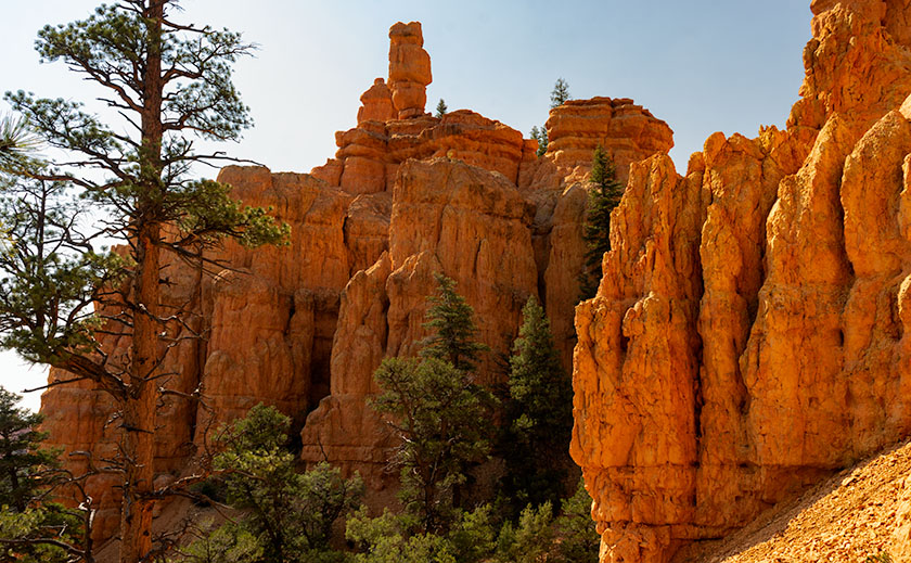
With persistence, we asked what options we had to hike among the rocks and take some photographs before she finally relented and provided us with a trail map. “This is the Pink Cliffs trail. It’s mostly intact on the east side, but people are getting lost on the west section of the loop. If you have trouble finding the trail, turn around and retrace your steps.” With that Anne and I set off for a short half-mile hike among the hoodoos.

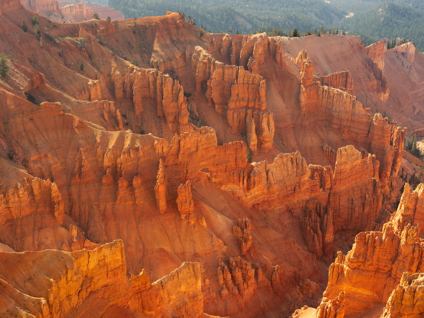
Following the trail wasn’t our problem. We had trouble finding the trail’s beginning. We walked across the parking lot to where the trailhead was and found the flood’s debris field. We made a couple of attempted starts. We walked up paths that could have been a trail including the debris field—which was fun because the field was one-inch sandstone chips. They were triangular and gave way as you stepped on them—like walking on a sand dune. I fell once when the loose rock gave way but as I fell I managed to grab a dead tree branch to stop my slide.

Anne found the trail and she called for me to come down and showed another group of lost hikers where it was. When I met up with her, we started along the real trail. There were places where water interrupted the trail, but you could pick out the other side once you understood what to look for. We spent an hour hiking with me happily snapping pictures and Anne grumbling the whole time. We even managed to navigate the dreaded west side although Anne fell on her butt once. It was when we got back to the parking lot that I realized that my lens hood fell off, and I knew where. This time Anne waited in the truck while I returned to the site where I fell on the talus slope. I managed to find my hood and while I was there, I gave the tree a hug.

Salt and Pepper
Salt and Pepper – The two most iconic hoodoos in Red Canyon. They’re visible from the highway and cause congestion when tourists stop to photograph the pair. They’re named for the dinnerware they resemble.

Did I mention that I did the hike twice? I had to because when we got back to camp, there was nothing on my memory card. No photos at all. I was upset but decided to go back for a re-shoot. I did that yesterday and had no problem finding or following the trail at all. I finished the hike in 45 minutes and that’s stopping to shoot everything again. I even took a picture of the spot where Anne fell and dented the ground. After I got back to the truck, I put the memory card in place for safekeeping. And that’s how the dog ate my homework and this blog is late.

Until next time — jw

Making Lemonade 2018 Utah Photo Shoot

As teenagers growing up in Los Angeles, we were ambivalent about the Santa Ana Winds. They would clear the air in the LA Basin, pushing it offshore where it was somebody else’s problem, and for a week or two, you could see where you lived and enjoy the beautiful mountains surrounding us. But the winds also dried out the scrub. Dry enough, a careless motorist could fire by flipping a cigarette out the window. Fires are a way of life in Southern California. They’re annual, but you don’t get used to it.

As a kid, I saw how smoke can choke the air, but I also saw a phenomenon helpful to photographers, although that didn’t sink in until I was older. When heavy smoke fills the air, it filters the sun—like sunglasses. During sunsets, the sun is an orange globe that you can look directly at. The smoky atmosphere causes beautiful orange sunsets. I don’t know if you’d call that a benefit, but they’re unusual.

After Monday’s shooting, I was processing some photos for yesterday’s blog when I glanced at the setting sun through Ritz’s window and saw an orange sun. Yesterday, as I wrote, I thought about trying to capture a sunset from my teenage memories. I decided to give it a go, and at 7:45, I drove north on US 89, looking for a suitable foreground for my sunset experiment. I settled on a spot where the sun would go down behind a lovely mountain—Sandy Peak. As a bonus, there was a vast field sprinkler spraying streams of water that would glow with the backlighting. I exited the truck and sat by the roadside, camera in hand, and waited.

The smoke in the air must have dissipated because as the sun got lower, it didn’t get duller, although it still had a tint of orange. I knew I would need to wait for the sun to kiss the mountain for the shot to work. That meant shooting when the sun was most colored anyway. Then, at 8:00, four children burst out of the house to my left. One got on a quad and started driving around while three girls—judging from the long dresses they wore—began running toward the sprinkler. When they got there, they turned off my sprinklers. I’m talking about one of those massive machines you see in fields moving on wheels in a circle. I’d be afraid to touch it, and these children turned it off like the hose in the front yard.

I thought about leaving, but the sun was inches away by then, and the girls hung around the fixture, so I adjusted the camera to bring up the foreground and started shooting until the sun slipped halfway behind the mountain.

Sandy Mountain Sunset
Sandy Mountain Sunset- This is my failed attempt to capture an orange sunset, but the story is nice anyway.

Here is my last and best shot. The smoke wasn’t thick enough, the water wasn’t spraying, and I have live humans in my photograph, but I thought I’d share my evening with you—at no extra charge. Can you find the girls? They’re there, I can assure you. Now, I can go back to shooting inanimate objects.

Until next time — jw

Cedar Breaks National Monument Utah Photo Shoot

Cedar Breaks Amphitheater - Cedar Breaks is a five-mile amphitheater that looks like someone took an ice cream scoop to it and left behind the candy toppings. The distant peak is Brian Head at over 11,000', where the ski resort is located.
Cedar Breaks Amphitheater – Cedar Breaks is a five-mile amphitheater that looks like someone took an ice cream scoop to it and left the candy toppings. The distant peak is Brian Head at over 11,000′, where the ski resort is located.

Yesterday could have been the perfect day to visit Cedar Breaks, the mini version of Bryce Canyon high on the eastern edge of the Markagunt Plateau in southern Utah. The muggy weather that had hung around all weekend moved out and it was dry and sunny with a light breeze from the west. As we entered the park the car’s temperature indicator said it was 68° outside. Conditions couldn’t have been better for an afternoon of hiking and picture-taking.

It wasn’t this nice the first time we visited Cedar Breaks. That was Memorial Day weekend in 2004. The Queen and I decided to get out-of-town to escape the 115° weekend. We had tossed the camping gear into the truck and left before dawn dressed in shorts and tee shirts. We drove straight through only stopping at the Flagstaff Mickey D’s for an egg-a-muffin. That truck didn’t have an outside temperature gauge and it barely made it up the 12% grade. We still had the air-conditioning on when we stopped in the parking lot. It was a sunny afternoon, but when we opened the doors, a blast of Arctic air greeted us and chilled us to our bones. We scrambled to find our jackets. At 10,300 feet, Cedar Breaks can be hostile.

Tee shirts and shorts were the perfect uniforms yesterday. That wasn’t a problem. The issue that I had was in the air. Up here, it’s normally clear and pristine, protected by its remoteness, but because somebody’s trying to burn down California, the air was filled with smoke that traveled across Nevada. That smoke-filled air is not conducive for taking detailed landscape panoramas. I had to change my mindset and look for more intimate images.

Bristlecone Pine
Bristlecone Pine – Probably over two thousand years old, bristlecones survive by shutting down damaged parts and only supplying new growth with nutrients.

From the visitor’s center, there’s a short one-mile hike to Spectra Point—an overlook that has a grove of large Bristlecone Pine trees. I’ve always admired these Methuselah trees for how they live for thousands of years in places where nothing else will grow. I had heard about them on my last trip, but it was spring thaw with snow covering parts of the trail and the rest being a muddy bog. That wasn’t an excuse today, so I put on my new camera backpack and balanced the tripod on my shoulder and set off to conquer nature.

Fins, hoodoos, and arches.
Fins, hoodoos, and arches – As the soft sandstone erodes it breaks down into long structures called fins. As the fins erode they leave individual spires called hoodoos. During that process, the bottom of the fin may fail and collapse leaving a window or arch. There are examples of all three in this photo. Can you spot the arch?

The trail actually leads to two overlooks, the second one being Ramparts. As I started skipping along I considered going the extra mile—as they say. It looked doable on the map because the parking lot is 10,300′ and Spectra point is 10,285′. A mere 15-foot drop—posh, child’s work. Ramparts, however, is 9,985′. I decided to see how I felt when I reached Spectra Point—after all, I have ridden a bike five miles every morning, so I’m buff … Right?

My skipping immediately ceased when I turned a corner and reached the base of a 300′ hill that’s not on the map. You can guess what my decision was already. I can walk three miles in an hour at home, but in the thin air, my trip took 45 minutes. I spent an hour shooting trees and views along the rim before heading back to Archie—our truck, where Anne was reading a book. You’d think she’d have carried the camera bag or a picnic basket or something. When I opened the back door in my sweat-soaked shirt and loaded the equipment while panting, all I got was, “How was your little hike dear?”

We spent today recuperating—she broke a nail—and I processed a couple of photos to show you. At dinner, we’ll decide where next to explore. We’ve concluded that the smoke has permeated Utah and we’ll just have to work around it, but we’re going to have fun even if it kills us.

Until next time — jw

Red Toadstool Picture of the Week

There’s a place on US 89 about halfway between Page, Arizona and Kanab, Utah where the road gets lost. As you know, odd-numbered routes run north-south, but this section of 89 goes east-west for 60 miles between the two towns and right in the middle the road hits all the compass points. There’s a perfectly logical reason they built the road this way. This is where US 89 cuts through the southern part of the Grand Staircase Escalante National Monument, and with three cliff tiers in front of you, it’s just easier to go around them.

The explanation for the five-mile section of looping road is the same. This is when the highway crosses a rift valley and climbs around to the north side of Buckskin Mountain. This is also the spot on the map that is a landscape photographer’s Mecca. You have probably seen photos of exotic geological features and wondered where they were taken. Places like The Wave, White Outcrops, Paria Canyon, Buckskin Canyon, Calico Mountain, and The Toadstools are all within fifteen miles from the road. The bad part of that—for us geezers—is that you must hike that distance to get to them.

This week’s featured image only required a jone-mile hike, but it involved a climb to a shelf 300 feet above the road. Once you make it, you’ll find a group of toadstools—columns of sandstone supporting a protective capstone. Although the trail up there isn’t flat, you don’t need to be an élite climber to make it. Queen Anne got far enough that she was able to watch her hero snap this photo, which filled her with so much emotion that she had to return to the car and do her nails.

Red Toadstool
Red Toadstool – A protective capstone is supported by a column of red sandstone near Kanab Utah.

I shot this toadstool from a couple of angles and after viewing the test strips back at camp, I preferred this version even though it’s smaller within the frame. The composition is stronger, and the image is uncluttered, so the formation becomes a stronger subject. The light wasn’t what I envisioned when I planned this trip, but the thunder clouds are kind-of cool. I call this image Red Toadstool and I’m pleased to start a month of Utah photos with it.

You can see a larger version of Red Toadstool on its Web Page by clicking here. I hope you enjoy viewing this week’s post and come back next week when we present another image from a different Utah site.

Until next time — jw

Welcome to Utah On Location

Welcome to Utah
Welcome to Utah – With rain cells all around, we stopped to memorialize the state change.

We made it to Utah in spite of getting lost in Williamson Valley because we missed the turn off for Chino. We had to back-track fifteen miles. We finally rolled into Kanab at 5pm and after setting up camp, we relaxed in Ritz’s air-conditioning. The temperature is in the 80’s but it’s really humid.

It’s been a while since we did any shooting in the Beehive State and I’m excited to revisit the National Parks along US 89. It seems like Utah has more National Parks than the other states. We plan on visiting three of them at least. I also want to check out other sites that I’ve heard about. We’re going to be here for a couple of weeks—at least.

It’s been a long day behind the wheel, so we’re making an early evening, but I wanted to get this post out before we crash. I plan on writing more about the things we see and do much like I did during last years Springerville trip, so be ready for more blog posts this month.

Until next time — jw

Kanab Utah

It took longer than planned, but we made it to Kanab Utah, our toughest leg of our trip. I think we misjudged the time it would take to go through Prescott. A lot of traffic and a lot of twisty roads. We left Congress a little after seven in the morning and arrived at our camping site just before 5 PM. Since Kanab is on daylight savings time, we lost an hour and the trip took ten hours averaging 45 miles an hour. That’s including potty breaks, emergency stops, and lunch.

The girls stretch their legs
Deb, Sally and Anne stretch their legs in the shade of Sally’s RV.

We only made it to the top of Yarnell hill when Sally called on the walkie-talkie that one of her tire pressures was over 100 pounds. We pulled to the side of the road and sure enough, it was. After letting enough air out to match the others, we were back on the road.

Mickie D’s hosted lunch in Flagstaff. After taking four hours to get there, we were ready for the break. After that we made really good time as the roads and weather were good.

Picture of Kanab's main street.
Located on the southern border of Utah, Kanab hosts tourists visiting the Grand Canyon, Bryce, and Zion National Parks.

Kanab is a little tourist town in southern Utah. It’s only six miles across the border from Arizona situated between the Grand Canyon, Bryce and Zion. It’s loaded with tourists and has a couple of nice restaurants. It’s most striking feature is that it is nestled under the Vermilion Cliffs and the brilliant colors they have at the end of the day.

Tomorrow we strike out for Provo. It will be a better day as the distance isn’t as great and there aren’t as many long pulls we have to climb. And to think, we only have 89 more days like this.

jw