White Barn Picture of the Week

I’ve been left home alone for almost a week now. Queen Anne had to fly halfway across the country to drag her friend back to the proper side of the Continental Divide. I keep telling you folks that nothing good ever happens on the other side of those mountains. She’s my editor, so if you find grammatical errors in this issue, you can blame her. Before she left, I told her that if she weren’t here, she wouldn’t get any press, so I’m not going even to mention her this week. It’s funny how you don’t understand how much you rely on someone until they’re gone. I miss her a lot—the sink is full of dishes, and I’m out of socks.

Smoky Sky - During the past few weeks, we've had atmospheric effects from the California fires. That smoke has drifted over our state and turned the sky white and given us red sunrises and sunsets.
Smoky Sky – During the past few weeks, we’ve had atmospheric effects from the California fires. That smoke has drifted over our state and turned the sky white and given us red sunrises and sunsets.

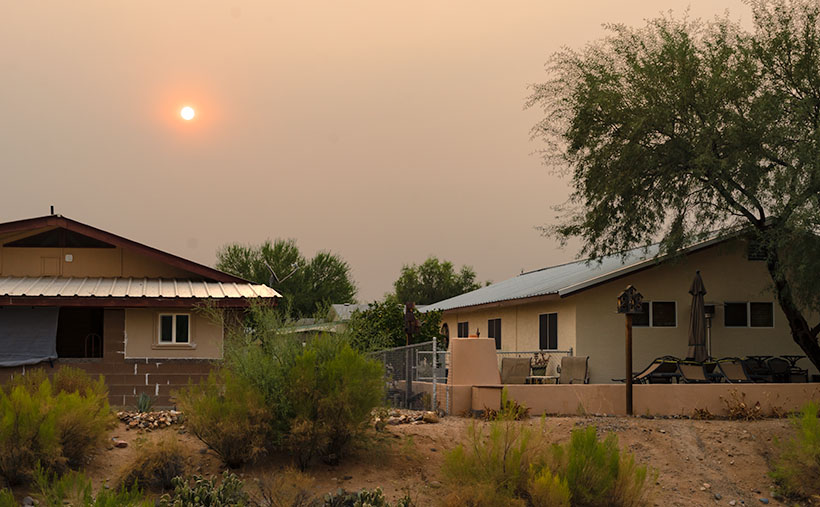
Another off-topic thing that I want to mention is how much the California fire smoke is making photography challenging. There’s a strange color cast, and it looks like it’s cloudy. The other morning, while I was riding my bike at sunrise, the sun was deep orange as it cleared the horizon. I grabbed my camera when I got home and tried to get that color on film. By the time I set up, the sun’s deep color had faded. You can see in this shot that the sun is exposed correctly, yet so are the houses. On a regular morning, that range of exposure would be more than my camera can record so that the buildings would be black from underexposure. You can’t escape the haze either. I was in Ajo this week, and the atmosphere was hazy there too.

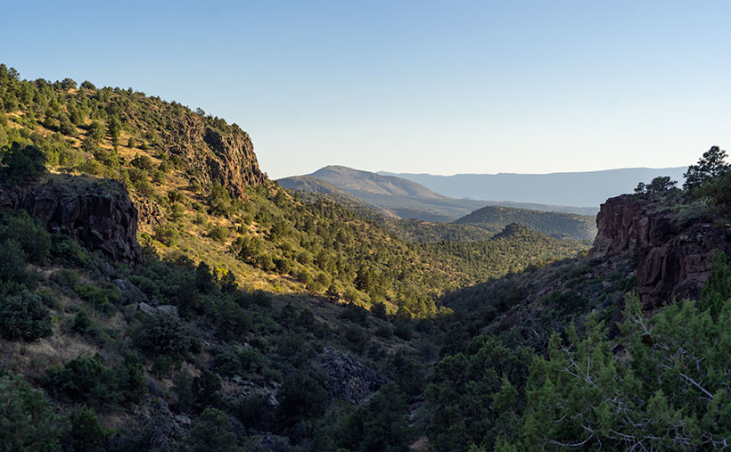
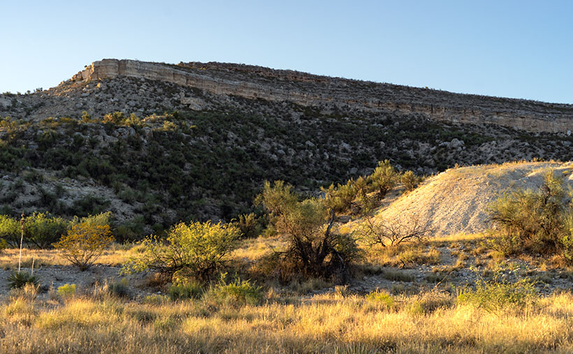
Now, where were we—oh right, driving General Crook’s trail. In last week’s episode, we stopped at 13 Mile Butte, which is about halfway up the grade out of the Verde River Valley. The climb isn’t as bad as some other routes to the rim, and if I intend to head east on Interstate 40, I usually go this way to get to Winslow. It cuts off a couple of miles, the grade is better than going to Flagstaff, and there’s less traffic. Once you’re on top of the rim, the road runs straight and flat.

White Barn - On a ranch near the edge of the Mogollon Rim, they are building a new barn. Still in its white Tyvek wrapping, it stood out like a jewel on the prairie.
White Barn – On a ranch near the edge of the Mogollon Rim, they are building a new barn. Still, in its white Tyvek wrapping, it stood out like a jewel on the prairie.

I took this week’s featured image shortly after we reached the plateau. On the south side, I spotted a ranch with a building under construction—maybe a barn. I don’t think it’s supposed to end up white. It was wrapped in the Tyvek moisture barrier and didn’t have siding yet. But, it gleamed in the sun well enough for me to stop the truck for a photo. It gives scale to the scene. I also liked how you can see the edge of the Mogollon Rim behind the building as it undulates across Arizona. I called this photo White Barn.

In The Pines - Once the General Crook Trail reaches the elevation of 7,000', it is surrounded by our countries largest contiguous Ponderosa Pine forest.
In The Pines – Once the General Crook Trail reaches the elevation of 7,000′, it is surrounded by our countries largest contiguous Ponderosa Pine forest.

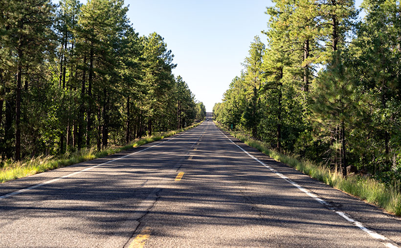
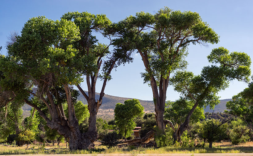
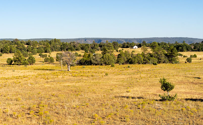
Since we don’t have a fifth Sunday this month, I’m including an extra photo, at no additional charge. I took this shot the road after Crook’s Trail enters the pine forest. When easterners think of Arizona, this is not the image that comes to mind. They believe we are one big desert with a great big ditch in the middle. But, this Ponderosa Pine forest is the largest contiguous stand in the country. It stretches across the state and into New Mexico. The plateau ranges from 7,000 to 9,000 feet, with a couple of 12,000 peaks on it. In summers, smart (or rich) Phoenicians either escape to San Diego or they have summer cabins up here. You can see why.

You can see a larger version of White Barn on its Web Page by clicking here. Next week we’ll begin a new journey somewhere in Arizona, so y’all come back and join us, ya hear? (Gawd, now I’m talking like the queen.)

Until next time — jw

13 Mile Rock Picture of the Week

Just thinking about road construction gives me a headache. I’ve had too many bad experiences traveling across the country. Don’t get me wrong; I know that roads need maintenance. Besides, I love driving on fresh pavement. It’s just that I’ve frequently gone across Arizona, New Mexico, and Texas in construction zones 10 or 20 miles long without any working crews. Inevitably, I’m stuck behind a Walter Mitty who’s afraid to drive over 25 when there are orange pylons on the road, and a close-up view of a Peterbilt 379 grill looming in my rearview mirror.

So, it’s hard for me to imagine a crew building a road—or in the case of General Crook, a trail—through pristine wilderness. It took them two summers to complete. During the first year, C.E. Cooley, Henry Dodd, and some troops from Fort Apache laid out the route to Fort Whipple. As a side note, this was the legendary trip where an Arizona town got its name. While camping in a White Mountain meadow, the men played a game of cards (I guess they couldn’t pick up a Wi-Fi connection for their iPhones), with the loser having to clean the evening’s dishes. The camp is now the town of Show Low, Arizona.

The second summer, a cadre of troops protected a construction team as they spent several months building a road wide enough to get wagons through. Imagine having to move rocks, clear downed logs, and building grades without a bulldozer. And even with all that hard work, their Yelp reviews sucked.

With each mile of progress complete, the construction crew left a marker, either carved into a tree or stone. Some of those markers are still there. The easiest to find is Mile 13 because the State has installed a historic plaque and turn-out on the south side. At mile 13, the road begins its ascent from the Verde Valley up the Mogollon Rim. It is east of the Fossil Creek road beside a large butte called 13 Mile Rock Butte.

13 Mile - From 13 Mile Rock Butte looking back down at the Verde River Valley, you can see all of the way to the Black Hills, which are on the far side of the river.
13 Mile – From 13 Mile Rock Butte, looking back down into the Verde River Valley, you can see all of the ways to the Black Hills, which are on the far side of the river.

This spot is where we stopped to take this week’s featured image. And I have to say that the view from there is pretty good. From above the Sycamore Canyon Ravine (5,000 ft elevation), you can see back down into the Verde River Valley. In the middle distance is about where the Fossil Creek Recreation Area is. Along the distant horizon is the Black Hills, which marks the Verde Valley’s south wall. Behind the knoll in the frame’s center, the Verde River turns south and becomes a designated Wild River from there until it empties into Horseshoe Lake near Carefree.

You can see a larger version of 13 Mile on its Web Page by clicking here. Be sure to come back next week and see where we stopped after reaching the top of the Rim.

Until next time — jw

Verde Limestone Picture of the Week

For centuries the Verde River Valley has been a peaceful home for many peoples. It makes sense because the Verde River flows year-round, even in times of drought—as we have now. The green waters of the Verde—Spanish for green—flow between the Black Hills (Mingus Mountain) on its south-west flank and the Mogollon Rim to the north-east. The river runs from Chino Valley to Fountain Hills—170 miles. It collects the runoff water from the rim via its tributaries like Sycamore Creek, Oak Creek, Beaver Creek, and West Clear Creek. Although the river bottom is a dense cottonwood forest, its flood plains are perfect for growing corn and squash.

There are many sites of early inhabitants along its length, but the best known is the pueblo of Tuzigoot—built by the Sinagua people in the 10th century. They only lived there for a couple of centuries before moving on. The next settlers to arrive were Apaches—Canadian migrants that were chased off the plains by the Sioux. The various bands of Apache established homes along the transition zones across Arizona and New Mexico. They weren’t aware that their new landlords were the Spanish, who were mostly interested in saving their souls and stealing their gold. For the next 300 years, life in the Verde River Valley was peaceful.

Then one day, in 1821, there was a knock on the door—er, teepee flap. It was a government man. He was there to inform one and all that they were Mexican citizens now and, by the way, do you have money to chip in for our new country?

After that, things began to happen fast, and life seemed to go downhill quickly. A mere 30 years went by when another man rode up on a horse, shook a bunch of hands, handed out flyers, and declared, “Welcome to America.” The very next year, Californians discovered gold, and easterners clogged up the trails rushing to get to it. Some got rich, but most of them didn’t get to the Golden State in time, so they made their way back and decided that our valley would be an excellent spot for a farm. There was a civil war going on back home anyway, so they moved into the neighborhood. The Apache’s homeland began to shrink.

In 1864, the Americans stuck a flag in the ground and called it Fort Whipple—the Arizona Territorial capital. The next year they moved the flag from Chino Valley to a mining camp on Granite Creek. The Army stationed cavalry troops to protect the miners, and that later became the town of Prescott.

Life was tense, but there was an uneasy truce between the tribes and the new settlers until those mangy miners started working the Verde Valley. They picked at the rocks, piled dirt everywhere, muddied the water, ate all the food, and drank all the whiskey. It was the straw that broke the Gila monster’s back, and the Apache tribes declared war—Yavapai War (1871-1875). That’s the precursor of General George Crook’s assignment to Fort Whipple and his trail to Fort Apache that we began exploring last week.

Verde Limestone - A limestone ledge in the Verde River Valley in the lovely light of the evening sun.
Verde Limestone – A limestone ledge in the Verde River Valley shines in the lovely light of the evening sun.

This week, we traveled east along the Verde River for a few miles and stopped near Dry Beaver Creek to photograph a limestone formation. They’re found throughout the valley and are most evident on the river’s north side. As you travel Interstate 17 towards Flagstaff, it’s the white layer between the Verde River and Sedona. Limestone forms in shallow seas from dead shells and bones. It’s a great place to look for fossils, and coincidently one of our planned stops was to be Fossil Creek, but it was closed due to COVID 19.

This week’s featured image—called Verde Limestone—shows a ledge exposed by years of erosion. For balance, I included the lower mound of the same compound shining in the lovely evening sunlight.

You can see a larger version of Verde Limestone on its Web Page by clicking here. Be sure to come back next week as we climb out of the Verde Valley and see what we found along the General Crook Trail.

Until next time — jw

Parade Grounds Picture of the Week

We Arizonans have it easy these days. Within a matter of hours, we can drive from the beaches of Yuma to the Flagstaff snowfields. We’re able to do that because of our modern cars and roads. With their bridges and gentle slopes, we forget how rugged our State’s terrain is. We sit in our air-conditioned cocoons and watch the scenery pass, without having to wonder, “How the hell am I going to get over that?” And the closest we ever come to getting scalped is from the guy selling souvenirs at The Thing.

Arizona was a different place when Martha Summerhayes arrived at Ehrenburg Landing via paddle-wheel steamer in the summer of 1874. She accompanied her husband—Jack, a Lieutenant—when the Army assigned him to the territory. She writes in her now-famous book—Vanished Arizona, Recollections of the Army Life of a New England Woman—about their travels to posts within our state, including her story of being the first woman to travel the subject of this month’s photo essay—The General Crook Trail.

George Crook was a Civil War officer who was assigned to Arizona to put a stop to Apache raids. Now, I fully appreciate the new awakening in our country about racial injustice, but that’s not the point of my story. I’m merely trying to explain, in my words, the trail’s history. George’s job of managing the Apaches wasn’t easy. They’re not a single people. There are the Chiricahuas, Yavapai, Mescalero, Tonto, and several more in Arizona alone. The tribe’s traditional homes were spread along the Mogollon Rim—the southern escarpment of the Colorado Plateau that slashes across the midsection of our state. It was like playing Whack-A-Mole; he’d quash one uprising only to have another pop-up 50 miles away. It didn’t take long for General Crook to understand that he had a logistics problem. He needed to move troops and supplies quickly from Fort Whipple (Prescott) to Camp Verde, and Fort Apache (near Show Low).

In August of 1871, the General took a company of men to mark out a trail between Fort Whipple and Fort Apache. It took over a month just to get that much done. His route hugs the edge of the Rim because if he went too far north or south, he had to navigate steep canyons. His men took another year to build a trail good enough for pack mules, and another couple of years to make it suitable for wagons.

Today, the General Crook Trail has morphed into a combination of Arizona Highway 260 and the Rim Road (Forest Road 300). The Rim Road is unpaved, and if you travel it, you’ll come across markers for Crook’s original pack trail. You can hike those sections, but a lot of the trail reviews say it’s easier just to walk along the dirt road.

Parade Grounds - A picket fence surrounds the Camp Verde Parade Grounds and make it a lovely back yard for the Commanding Officer.
Parade Grounds – A picket fence surrounds the Camp Verde Parade Grounds and makes it a lovely back yard for the Commanding Officer.

For September’s project, I’m only going to cover the section of A.Z. 260 from Camp Verde to the intersection with A.Z. 77 north of Strawberry. This week’s featured image is from Camp Verde, where they’ve turned the old post into a historical site. The Camp Verde Historical Society has preserved the buildings, built museums, and maintains the parade grounds within the State Park. It’s a great way to spend a day wallowing in history. This week’s image—called Parade Grounds—shows the parade grounds and the surrounding picket fence, with what I suspect is the Commanding Officer’s Quarters behind. How’s that for a back yard?

You can see a larger version of Front Parade Yard on its Web Page by clicking here. Be sure to come back and see our next stop along the General Crook Trail.

Until next time — jw

P.S. Martha’s book, Vanished Arizona, is not just a chick-book. It’s got cowboys, Indians, horses, rattlesnakes, and cactus in it. What more can a boy want? I smiled when she lamented how much Arizona had changed from her 1874 arrival to her 1911 death. It is the same feeling that most Arizonan have even today.

Front Yard Trees Picture of the Week

Are you a punctual person, or are you chronically tardy? Our house is split evenly. Queen Anne always manages to be 15 minutes late. Even if I try to compensate by giving her a false time that we should leave to get somewhere, she somehow knows and still isn’t ready on time. One phrase that you will never hear from her is, “Sorry, I’m early.” That is a novel concept to her. It drives me crazy, and she knows it. But then she speaks to me in her low, breathy voice and circles her finger around my remaining chest hair, and then I remember why I love her so much. She’s a good cook—well, she cooks a mean bowl of cereal.

A reason that I’m writing about punctuality is that this year’s monsoons have finally shown up to the party—six-weeks late. One thing that makes Arizona summers bearable is watching majestic thunderheads build up over the mountains in the day and then enjoying the evening thunderstorms from the porch. When the summer rains arrive, they break the extreme June and early July temperatures by about ten degrees. This year, our first rain didn’t come until last week, so it stayed hot through July and August. We had 50 days of temperatures above 115º, a new record. June, July, and probably August will go down as the hottest recorded, and without the refreshing rain, brush fires have plagued the state. The smoke from California and Arizona fires has added to this summer’s miserable conditions.

Things changed last week. Between the gulf flow shifting west and a tropical depression off the coast of Baja, there are pretty clouds in the sky, and the temperatures have dropped—the last couple of days have been under the century mark. As I write and look out my office window, I can see cumulus clouds building towers over the Weaver Range. Maybe we’ll have rain again tonight. I think I’ll go to the car wash and improve our chances.

Front Yard Trees - Tall cottonwood trees grow along the road-side in front of a Ferguson Valley ranch.
Front Yard Trees – Tall cottonwood trees grow along the road-side in front of a Ferguson Valley ranch.

Looking back at the photographs from this month’s portfolio, I wonder how different they might have been, had the skies been more dramatic. Take this week’s featured image; for example—the treetops stand in for clouds. Had the sky been brimming with fluffy cumulus clouds above Baldy Mountain, would I have seen the scene differently? I can visualize that image being less about giant cottonwoods along a rancher’s fence line and more about the mountain in the background. In any case, I have to work within the given conditions, and so I took this week’s photo—called Front Yard Trees—as it was then.

You can see a larger version of Front Yard Trees on its Web Page by clicking here. Next week we’ll begin a new adventure out along another Arizona road, so come back and find out where the trail leads us.

Until next time — jw

Standing Rocks Picture of the Week

Do you remember my buddy, Fred? He’s been an actor in several of my adventures when his wife allows us to go out together. The truth is that his wife—Little Deb—and I have been longtime friends. We first met when we were both decorators at a local curtain shop, and have counseled each other through our serial marriages. I think well enough of her that I asked her to be my best man when Queen Anne and I tied the knot.

Miss Deb—as we call her now that she’s a grandma—has a caring heart, and—unlike me—will drop everything to help people out, sometimes to a fault. She must have been a nun in a past life, and she’s shorter than Sally Field (so, two and two equal Flying Nun). At one point in her life, she went through a goose phase. The art in her home involved all kinds of poultry. I think it influenced her maternal instinct because she fusses about her kids, and now grandkids, like an old mother goose.

She does have one idiosyncrasy—well, maybe more than one, but we’ll talk about those some other time. She collects rocks. Each time we’d go camping, we’d drive home with a backseat floor full of rocks—pretty rocks, interesting rocks. When she got back to the house, she would wash them, label them like an archeologist, and then carefully place them out in the yard. She’s trained Fred well. Each time we go out together, he kicks at the dirt, looking for pretty rocks to bring home. So far, they’re working on their yard’s third layer.

I tried it, and it works for me too. When I’m out on a shoot, sometimes I’ll pick up a hardened piece of dirt and toss it in the truck. When I get home, I’ll present it to Her Majesty and sincerely look her in the eyes and tell her, “I found this pretty rock, and thought of you.” Then I tell Anne that I think there’s a gemstone hidden inside. She always says, “Thank you, honey,” before she rushes to the sink with her Waterpik and tries to erode the stone to expose the jewel. It keeps her busy for hours.

Standing Rocks - A cluster of upended granite boulders that we found at the edge of a field in Ferguson Valley.
Standing Rocks – Here is a cluster of upended granite boulders that we found at the edge of a field in Ferguson Valley.

That’s the story of why—whenever I’m out on a photoshoot—I always wind up with pictures of rock piles—like this week’s featured image that I call Standing Rocks. “I saw these and I thought of you.” On our August outing to Ferguson Valley, we passed a group of granite boulders at the edge of a field. These are the same granite boulders found scattered throughout central Arizona, except some cataclysmic event upended these. They could be the Jolly Green Giant’s headstones in a cemetery overgrown with scrub oak. Anyway, when I saw this scene, I had to stop and snap a picture just for you.

You can see a larger version of Standing Rocks on its Web Page by clicking here. I hope you enjoy your rocks. I think there may be a jewel hidden in them. Be sure to come back next week for another Ferguson Valley image.

Until next time — jw

Brushy Mountain Picture of the Week

 What’s your favorite color? Mine’s blue—I don’t know why, but it’s always been my go-to color. Perhaps my mother once said that it’s the color of my sparkly eyes—but then, what about my red nose? Because I like blue, I’m a commoner. A higher percentage of men and women chose blue as their color favorite. According to some Websites that I looked at, the second most popular color was either red or green. Surprisingly, yellow had the least amount of fans, but as we age, orange works it’s way to the bottom of the list. By the way, Queen Anne’s favorite is green—as in emeralds—but she wouldn’t toss a ruby out of bed for eating cookies.

If I had to pick a Crayola to color in a map of Arizona, I’d look for a color that looked like dirt. There are the reds and vermilions from the Colorado Plateau, the gold granite of the central highlands, the yellow fields of the grasslands, and the browns of the desert ranges. When I got done, the green crayon would still have a sharp point. I don’t associate green with Arizona. That color belongs to Ireland, New Zealand, or maybe Kentucky.

Sure, Arizona has a lot of greenery. Our cactus, our palms, the pines, and the Scottsdale golf courses are green, but not that vibrant hue that people in other states have. When we come across a small patch, we believe we’ve found an oasis.

Brushy Mountain - Brightly colored cottonwood trees are a sign of water nearby.
Brushy Mountain – Brightly colored cottonwood trees are a sign that water is nearby.

That’s what happened when I captured this week’s featured image. As we drove the Ferguson Valley Road, we saw a grove of healthy cottonwood trees growing in an unnamed wash. As I’ve written before, a grove of deciduous trees with Kelly-Green leaves means that there’s water near the surface. Sure enough, when I checked the Topo maps for names, they showed a spring seeping from the ground near Coughran Canyon near Skull Valley.

When I composed this image, I wanted to contrast the shade trees against the dryer chaparral and mountain in the background. It speaks to me as an island of cool in a sea of heat. I called this picture Brushy Mountain, which I’m guessing is the spring’s water source.

You can see a larger version of Brushy Mountain on its Web Page by clicking here. I hope you like it. Be sure to come back next week for another image from Ferguson Valley.

Until next time — jw