Harbor Fog Picture of the Week

Harbor Fog - A dense fog covers the Avalon Harbor.
Harbor Fog – A dense fog covers the Avalon Harbor.

Do you have a bucket list? If you don’t know what I’m talking about, it’s a list of things you’d like to see or do before you die. The concept existed before Rob Reiner’s 2007 movie The Bucket List (starring Jack Nicholson, Morgan Freeman, Sean Hayes, and Beverly Todd), but maybe the film made this type of to-do list more widespread.

As I wrote at the beginning of this month’s project, we chose to go to Catalina because the island was on Queen Anne’s list. She’s bugged me for years about going. We had a lot of fun, so I’m happy we went. However, more adventures remain on her list, including seeing the Northern Lights (she claims that she’d settle for the Southern Lights, but I’m not sure that’s the truth). Anne is always showing me deals on Iceland tours from Travel Zoo. The hitch is that the best time to see the lights is in the middle of the night in winter. I can’t imagine dragging her from a warm bed into the freezing night.

I’ve never honestly compiled my bucket list. I married a wonderful woman; what more do I need? Besides, if I had such a list, I’d be afraid she’d kill me if I finished it. She’d say, “You’ve had your fun; now it’s time for you to go.” That’s why we’ll never own a chest freezer.

After we returned from Avalon, Anne asked several times if there was something that I wanted to see or do. I’ve been thinking about it since. In my late fifties, I realized that I was never destined to be rich or famous, so dreaming of yachts, private airplanes, or exotic cars was a waste of my time. With that burden gone, I’ve had time to learn about the poor slob I am. Over the last couple of decades, I’ve winnowed my hobbies so that I can concentrate on photography. Since I retired seven years ago, I no longer call myself a designer or computer programmer. Now I’m a photographer, and I’m happy about that.

On the other hand, one goal that has eluded me involves fishing. Since my ex-brother-in-law introduced me to trout fishing, I’ve always dreamed of landing a fish over ten pounds. During our 2016 Alaska trip, I had my best (and last?) chance of accomplishing that goal because Fred and I were going after salmon. My best catch that summer was the nice silver salmon I landed on a fly. It was eight pounds. Close, but not cigar worthy.

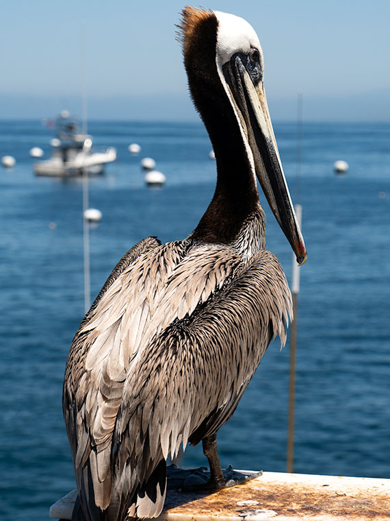
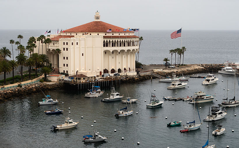
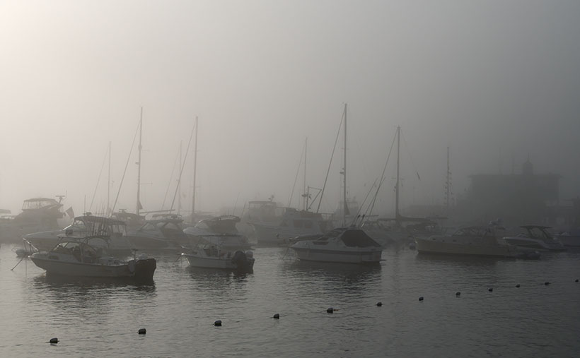
I haven’t been on the water since, and I put that lunker idea out of my mind—until we got home from Catalina. When we researched adventures to fill out our week, I came across fishing charters, specifically fishing for tuna. I discarded the idea because this trip was to celebrate our anniversary, and leaving Anne alone in a sailor bar while I was out all day on a stinky fishing boat didn’t seem right. But sailing out into the open waters off Catalina’s west coast intrigued me. I prefer a nice piece of tuna over steak; they come in large packages. So, I started my first bucket list. Next, I have to research the best season and place to hire a boat—like the ones you in this week’s picture.

One morning in Avalon, I woke up and left to take pictures. When I went outside, I found dense fog. I might as well be in London. Since I’m used to the clear desert air, this was both a challenge and a treat. I ran around town, reshooting everything I had done over the past days but in the fog. I wanted to show the weather but still have a subject identifiable. This week’s image, which I call Harbor Fog, is the one that worked best. It was taken on the harbor’s north side looking south. I like how the morning sun tries to burn through the low clouds, how the boats fade in the distance and the faint hint of the pier buildings in the right background. What do you think—did I get it right, or should I stick to the desert? You can see the larger version of Harbor Fog on his Web Page by clicking here. Come back next week to see another side of Avalon.

Till Next Time
jw

Pete Picture of the Week

Pete - the opportunistic pelican waits at the end of the Avalon Pier for someone to bring lunch.
Pete – the opportunistic pelican, waits at the end of the Avalon Pier for someone to bring him lunch.

When you’re on an extended stay at a resort town, there’s only so much time you can shop for T-shirts, scarf down gelato at Scoops, or inhale pastrami hoagies under the umbrellas in front of Antonio’s. You need a break in the routine—we crave adventure. Tour operators know this, and that’s why they do well in high-traffic attractions like Avalon. They’re the carnival rides at the State Fair. Instead of riding grease-stained high-speed Merry-go-rounds, these carnival barkers use gimmicks like parachutes, steel cables, bungee cords, or jump from a perfect airplane to take money from your pocket. Being the big fella I am, I don’t have faith in those contraptions.

When Queen Anne and I planned our week in Avalon, we poured over the adventure packages the town offered. Given our advanced stage of dementia, superior physical fitness, and risk of cardiac arrest, we chose to look at stars through a telescope, ride a boat with a glass bottom, and take a drive in a Hummer. None of those activities involved walking, climbing, or jumping. The only exertion we made was finding a seat.

The stargazing was a bust. The hostess doesn’t offer tours until the warm summer months. That’s because you need clear skies to look at stars, and the cooler months have persistent fog. All that you would see through the telescope would be cloud bottoms.

Garibaldi - the little golden fish doesn't go after the chum. Instead he's protecting his nest from the other fish.
Garibaldi – the little golden fish, doesn’t go after the chum. Instead, he hopelessly tries to protect his nest from the other fish.

The boat was fascinating but less exciting than we had hoped. There are two versions of this tour; the original glass-bottom boats and another they call a submarine. The former is open to the sky and looks down through the hull. In the latter version of the ride, you climb into a tube, sit,  and look through windows along the side. The sub never submerges. Since it’s dark inside the sub, you can see better through the dirty windows. After everyone is loaded, the sub (ours was painted yellow, of course) motors to a small bay south of the main Avalon harbor, where the crew tosses food into the water. The food attracts so many fish that they cover the windows. It’s cool, except their advertisements hint that you might see marine mammals, sharks, or mermaids. Chances are that you’ll only see the locals. We thought it was a fun hour-long boat ride through the kelp forest.

Mike Bison - Our jeep driver, Chief, spotted Mike napping in the grass and drove to where we could take his picture.
Mike Bison – Our jeep driver, Chief, spotted Mike napping in the grass and drove to where we could take his picture.

The ridgeline jeep tour was our only chance to see other parts of the island. On these tours, they load 4 to 8 people in the back of an open Hummer and drive the dirt roads along the mountain ridges. I suppose you could walk or bike around the locked gates, but that’s exercise. It was foggy during our trip, so we didn’t enjoy any grand vistas possible from the mountain tops. There were times when we saw the city below and caught a glimpse of an empty west-coast bay through the damp mist. One of the tricks the guides routinely pull on the unsuspecting tourists is to stop at a steep fire break that crosses the ridgeline. After explaining how firefighters built the gap to slow spreading wildfires, the driver shifts the Hummer into low range and begins to drive up the steep ridge until the passengers all scream for him to stop. But, after riding with Fred in the San Juan Mountains, I’ve done worse. The highlight of our ride was the ‘puppy’ our guide—Chief— spotted napping in the tall golden grass. Chief stopped the Hummer and got him to sit up so we could take Mike’s picture.

Another thing we considered—but ruled out—was hiring a fishing charter. The captains claim that there are some nice fish to be caught off the island’s west side. In Avalon, you’ll see people carrying fishing gear, so there must be some truth to their claims. Some locals will go to the pier’s end in the mornings and fish for shad and other bait fish. Then they head for deeper water in boats and fish for big trophies. That brings us to this week’s picture that I call Pete. Pete was an opportunistic brown pelican perched on the pier railing waiting for one of the anglers to drop their catch. Why plunge into the cold ocean for lunch when someone brings it to you? He must be used to people because he let me get this close-up shot without flinching. He was content sitting there until a young girl tried to touch his feathers. That was a step too far. We watch Pete drop 20 feet to the water and skim along the blue surface. Without flapping his broad wings, he picked up speed, then circled overhead the girl and her father walking hand in hand along the boardwalk, and then he expressed his displeasure—splat.

You can see the larger version of Pete on his Web Page by clicking here. Come back next week to see another Avalon photo and read about our adventure.

Till Next Time
jw

Avalon Casino Picture of the week

Avalon Casino - The Art Deco style building opened in 1929 the large gathering hall was never used for gambling. There is a movie theater and ballroom inside.
Avalon Casino – The Art Deco style building opened in 1929. The large gathering hall was never used for gambling. There is a movie theater and ballroom inside, so as you’d suspect, it’s a favorite spot for Southern California brides.

Listen, guys, I know this goes against the man code, but you really should pay attention to your wife every so often. This seemingly innocent act of unselfishness pays dividends. She may let you watch the race (game?) and cook a pack of pizza rolls for you; she could let you play golf, or—in my case—the sock-fairy returns a drawer full of footies before I order another pack from Amazon. You got to try it. A little act of kindness pays off tenfold.

By now, you’re probably wondering what I’m babbling about. Let me explain. Here at the Witkowski double-wide mansion, we’ve had the fortune to get small returns from the IRS over the past couple of years. We treat it as unexpected vacation money, but we always spend it on tires, garage doors, or new cameras. This year, we didn’t have any incidental expenses, so I asked Queen Anne, “Honey, where would you like to go on vacation.” At first, she squinted and scowled at me, but when she realized I was serious, she answered, “Catalina Island is high on my bucket list.” So, we agreed to blow all our tax returns on an island for a week.

Before I get too far, let me clarify a point. Unless you own a yacht, you’re into backpacking, or your family name starts with Wrigley, you don’t visit Catalina; you go to Avalon. They don’t have rental cars on the island, but you can rent a bike, golf cart, or steal a local’s Smart Car, but you’re mostly going to walk around town. We didn’t mind because that was enough to keep us entertained for the week.

Although Avalon is still in Los Angeles County, its atmosphere makes you feel like you need a passport to travel there. First, the air is free of LA smog so that you can see the mainland’s San Gabriel Mountains through the fog. As you walk past the shops and bars on Crescent Avenue, you get the aroma of sea air mixed with waffle cones, beer, and pizza. The businesses along the strand are the same mix of souvenir shops, restaurants, hotels, ice cream, and adventure tours that you’d expect in any popular tourist attraction. We spent the week scouring through all the T-shirt shops before selecting a couple to bring home.

Before we even left home, I knew one of the photos I would take would be of Catalina’s iconic casino. Since I had plenty of time on the island, I took nearly a dozen. I shot it in the sun, in the fog, under a cloudy sky, from ground level, and this week’s featured image is from the cliffs overlooking it. I picked this version to show because it has soft shadows, and you can see its details and its relationship with the harbor. I call this image Avalon Casino even though its actual name is the Catalina Casino.

The Santa Catalina Company built the building and opened it in 1929. They never used it for gambling. ‘Casino’ is a European term for large gathering hall, but Vegas operators thought that casino sounds more hoity-toity than gambling hall, so they stole the word. The multi-story hall is the largest building on the island, and its art-deco design has fans worldwide (I’ll have more to say about that in a couple of weeks).

This week’s photo also includes my dream boat. Can you guess which one it is? It’s not the biggest, but it’ll do. I’m scheming a way to have Santa bring it for Christmas, so after I publish this morning, I have to do dishes and mop the floor. I got to keep the jolly old elf happy, you know.

We’ll spend the rest of our hot July remembering our Avalon trip. You can see the larger version of Avalon Casino on its Web Page by clicking here. Come back next week and see more from our Avalon adventure.

Till Next Time
jw

My Tracks  Picture of the Week

It’s the end of January already, and we have a final image from the Algodones Dune Field to talk about before moving on to a new project. I’m not sure that I’m ready. At the beginning of the month, when I started writing about the Algodones Dune Field, I wasn’t sure there was enough information for five articles. But, there was enough for that and more—like the relationship between the dune field, Lake Cahuilla, and the San Andreas Fault. If I aroused your curiosity, you’re going to have to hit the books yourself.

After working on this week’s picture, I realized that shifting sand was also a metaphor for time passing (Wasn’t there a daytime soap called, The Sands of Time? If not, there should have been.) As I examined my photos of endless piles of sand, I wondered why someone hadn’t come up with a way to put it to use. That was until my brain’s hammer came crashing down with an obvious answer. They have, or had—it’s already been done. You see the device every New Year with a picture of father time holding an hourglass about to run out of sand; of course, an hourglass. Why didn’t I think of that?

I even bought one a long time ago when I was wet behind the ears. I was still in the Army and stationed in Pasadena, California. My brandy new and very young bride—neither of us could legally drink in bars at the time—leased a furnished apartment three blocks north of Colorado Boulevard for a year. We didn’t need furniture as we set about nest building, so we bought shiny things from our local head-shop. There were posters taped to the wall (we couldn’t put nails in the drywall), kitchen trinkets, an alpaca throw rug, and a three-foot-high hourglass.

It was harvest gold that matched our appliances. It was big enough that we used it as a side table. We regularly turned it over when friends visited, but that soon got boring. I still don’t know how long it ran because I couldn’t afford a stopwatch, and when I tried timing it with the stove clock, my ADD kicked in, and I forgot what I was doing. I believe it was somewhere between 45 minutes to an hour.

After four years, the hourglass was one of the things I got from that divorce. I don’t know what happened to it, but I suspect that it turned bright flaming red in the eyes of one of my subsequent wives and wound up at Goodwill (assuming they were that kind to it). It wasn’t like I immediately noticed the day it was gone; I simply realized that the clock was no longer part of the decorations.

With how precise we can measure things these days, you’d think building an ultra-accurate hourglass would be possible. We could sift sand to within one micron, machine a precise orifice, and calculate the right weight to make the sand run out within a nanosecond. The results would make a super-accurate timepiece—once. It would quickly become out of tolerance because it grinds the hole imperceptibly larger while the sand flows. I guess I’ll just stick with my trusty ol’ Timex.

My Tracks - I photographed the set of tracks that I made on the Algodones Dunes to have a semi-permanent record that I was there.
My Tracks – I photographed the set of tracks that I made on the Algodones Dunes to have a semi-permanent record that I was there.

For this week’s picture, I wanted to show a semi-permanent record of my footprints in the sand. In real life, my tracks probably disappeared in hours—or days if the wind was calm. After taking last week’s photo, I headed back to the road. I turned before leaving the dune and shot this photo that I call My Tracks. The giant mess at the dune’s top is mine, and if you look closely, you’ll find other fainter tracks. Near the bottom are bug tracks, and there’s a set of coyote (or fox) tracks in the middle. There will always be some tracks in the dunes if you take time to look.

You can see a larger version of My Tracks on its Web Page by clicking here. Next week we move on to another location in search of natural beauty. Come back then and see where we landed.

Until next time — jw

Wilderness Dune  Picture of the Week

Although I’m sure that chasing each other around dunes in Mad Max-style is fantastic fun, being an artist and naturalist, I prefer my sand without tire tracks. If only there were an area of the Algodones Dunes like that. Fortunately for me—and you, if you feel the same—there is. It’s across the street in the North Algodones Dunes Wilderness Area. This set-aside area starts at the highway and continues north for another 15 miles to the Salton Sea. The only tracks you’ll find are those of the critters calling this home.

Wilderness Dune - You can explore dunes without tire tracks in the North Algodones Wilderness Area, which is across the street from the Imperial Dunes Recreation Area.
Wilderness Dune – You can explore dunes without tire tracks in the North Algodones Wilderness Area, across the street from the Imperial Dunes Recreation Area.

For four weeks, we’ve been walking with sand-filled shoes, and you’re asking, “Why is all of this here? Aren’t sandy beaches associated with large bodies of water?” Well, you’re right—here’s your gold star.

Here’s an interesting fact about Imperial Valley, much of Coachella Valley, and the Salton Sea—they’re below sea level. When you drive to San Diego on Interstate 8 and pass the Calexico exit—on the south side, there’s a large water tank rising from the lettuce fields with a painted mark indicating sea level. The grade runs downhill from there north to the Salton Sea. This entire basin was once underwater.

“So, was the Salton Sea much larger then?” No, grasshopper. California’s largest lake is not a ‘natural wonder.’ It’s an engineering blunder. The lake is the result of underestimating the Colorado River’s floods, which resulted in irrigation canals breaching their dykes, diverting the river for two years (1905-1907), and sinking the small community of Salton under 52 feet of water. The Sea suffers from decades of farm runoff laced with high fertilizer and salts that killed everything living in it. It’s now a toxic cesspool best viewed from miles away.

What actually happened was that the entire Salton Basin was part of the Sea of Cortez. Over time, the Colorado River Delta dumped enough sediment to bridge the gap between the mainland and a mountain chain off the western shore (today called Baja California). Like how the Mississippi formed Lake Pontchartrain in Louisiana. The historic landlocked body of water is named Lake Cahuilla (don’t confuse it with the Cholula hot sauce, as I did).

After the last Ice Age, Lake Cahuilla (ka-we-a) began to dry because there was not enough runoff to keep it filled. It finally went dry sometime after 1580. We know the lake existed then because the Spanish sailed ships past the delta into the lake. Today researchers have evidence of old shorelines and native archeological sites around them, providing evidence that people lived in the area for centuries. On the lake’s eastern shore was the Algodones Dunes. Geologists believe that the prevailing northeasterly winds carry Salton Basin sand aloft then dumps it at the foot of California’s Chocolate Mountain Range. Aw geez, now that Queen Anne has read this, she wants to go there because she thinks it’s where Willy Wonka lives.

This week’s photo shows a pristine dune I took from the roadside. The bad news is that you can’t stop here for at least two miles on either side of the fee area described in previous posts. So, to get this shot, I could’ve parked far away and hiked back (uphill in both directions) or paid the $35.00 fee. I’m lucky and glad that the Rangers took a day off.

You can see a larger version of Wilderness Dune on its Web Page by clicking here. Next week we’ll have the final Algodones Dunes story, so come back then.

Until next time — jw

Dune Avalanche Picture of the Week

Dune Avalanche - When the angle of wind-blown sand meets or exceeds 35 degrees, the sand collapses under its own weight and slides down the dune's leeward face.
Dune Avalanche – When the angle of wind-blown sand meets or exceeds 35 degrees, the sand collapses under its weight and slides down the dune’s leeward face.

My sisters and I never got to play in sandboxes when we were toddlers. My dad said it was because the cats kept covering us (cue drum). That joke was the extent of my dune knowledge until this month’s project. It turns out that they’re pretty complex.

For example, I thought they were a large pile of uniform sand grains. Not so. Only the grains on the surface layer are the same. Below—about a yard (or a meter, if you’re Canadian)—is another layer where the sand grains are large enough that wind can’t lift them. The surface has even more refined grains that get picked up and suspended in the air—like dust—and carried to faraway places. Recently, scientists found that dust from the Sahara Desert is held aloft high in the trade winds and falls back to earth in the Amazon Rain Forest. The settling dust is the source of nutrients supporting jungle plants. The soil in that area of Brazil is otherwise nutrient-poor because the river constantly flushes everything out to sea.

The weirdest fact that I learned was that dunes could sing—not like in tunes from Rocky Horror Picture Show—but a deep booming bass note (70-100 Hz). Conditions have to be perfect. The sand must be dried (in the hot summer), it must be windy, and the dunes must be tall—120 ft or more. The Algodones Dune field is not that high, but the Dumas Dunes between Barstow and Las Vegas are, so now I have to hear this for myself.

Here’s how it works. As wind moves over the field, the windward face of the dune forces air up and move faster—like an airplane wing. The fast-moving air picks up sand from the middle of the face and drops the sand at the top. When the angle of the top sand exceeds 35 to 38 degrees, it’s not able to support its weight, and it begins to slide down the dune’s leeward face—as we see in this week’s image called Dune Avalanche, but on a larger scale. As the sand slides, it creates vibrations reflected off the denser layer beneath—like the strings and body of a cello work together to make music. If you’d want a more thorough explanation from a more credible source, you can watch What Makes These Dunes Sing? (ft. @It’s Okay To Be Smart) on YouTube, but be warned, you need a good bass response from your speakers, or you won’t hear the song. And you thought last week’s story about the sandworms was fantastical.

I took this week’s picture at the Imperial Dunes Recreation Area, as you can guess by the tire tracks in the background. When I saw the sloughing sand, I knew that it was essential to the ecology of the dunes, but I didn’t appreciate why. After this week’s research, I’m glad that I snapped the photo, and—as I said above—I want to check out the Dumas Dunes and maybe go back to Death Valley. I want to hear their song—but do I want it bad enough to go when it’s 120 degrees?

You can see a larger version of Dune Avalanche on its Web Page by clicking here. Next week we’ll poke more into the beauty of the Algodones Dune Field, so come back then.

Until next time — jw

Predator Tracks Picture of the Week

We need to drive an hour to show you a different part of the Algodones Dunes. I hope you had breakfast because we’re not stopping. There are only two roads that cross the dunes, Interstate 8—east of Yuma and California State Highway 78. We’ll hop onto I-8 and head west to Holtville, then north to Brawley.

Most of this drive is flat and dull except for the towering green John Deere tractors that take up three lanes of the two-lane road. The farmers drive them on public roads to remind you that if you eat steak and salad in winter, this is where they were likely grown—either here in the Imperial Valley or Yuma.

Once we get to Brawley (there’s a bypass, so thankfully, we don’t have to go into town), we’ll turn west onto S.R. 78—the road to Blyth (boy, it keeps getting worse, doesn’t it). It isn’t far out of town that you see a cloud bank on the horizon—or at least that’s what it appears to be. The sand reflects light on a bright day, and the detail gets lost. The shapes and color begin to resolve in another mile, and the windshield fills with an overwhelming sea of golden sand.

We have arrived. This area of the dunes is the home base for So Cal dune-buggy enthusiasts. As soon as the highway starts up the sand, you’ll see Gecko Road on the right. It’s a paved street loaded with vendors, campers, and rangers. This road is a fee area, so we may have to buy a permit if the rangers come to work today. There are several designated camping areas along the road, and they’re full of R.V.s and trailers—even in the middle of the week. Judging from the size and luxury of these rigs, they’ve come from the L.A. Basin—and they’re richer than anyone from Arizona. There must be a thrill racing up and down dunes; otherwise, what’s the point? I wouldn’t try it in Archie, but with Bluto, I might. It could be fun.

Predator Tracks - An innocent victim was snatched from her friends by a giant sandworm California's Imperial Dunes .
Predator Tracks – An innocent victim was snatched from her friends by a giant sandworm in California’s Imperial Dunes.

It can also be dangerous. Some creatures live in the sand that nobody’s seen—their tracks are the only evidence that they’re real. They’re called sandworms, and they feed on unsuspecting victims as they try to cross. It’s true; they were in the ’90s movie Tremors, and you can see for yourself in this week’s picture called Predator Tracks. In it, you see footprints from a herd of bikini-clad tawny blond valley girls, moving north across the sand while staring at their phones. They were defenseless because they ignored their parent’s warning to take a chainsaw.

As they incessantly chattered about their Instagram likes, they overlooked the sandworm lurking behind a distant mound. Like dolphins feeding on a school of mackerel, the sandworm blindsided the girls. From their midst, it snatched Cassie in its massive jaws and drug her under as she complained about losing all her bars. None of the others noticed. They continued to the snack truck making snide remarks about how Cassie had just ghosted them. The only record of this tragedy is the tracks in the sand in my photo. Within a couple of days, even those will blow away.

You can see a larger version of Predator Tracks on its Web Page by clicking here. Next week we’ll hang around the Imperial Dunes and see what other sand tracks we can find.

Until next time — jw