Lava Grass  Picture of the Week

Christmas, along with the rest of the solstice holidays, is almost over. I hope that Santa brought you something better than the lump of coal I got. Queen Anne is on the couch in her bathrobe and tiara with a box of Kleenex. She’ll be useless until Amazon Prime stops showing Christmas movies. Since we won’t be back before then, we’d like to wish you the best New Year in 2022. Things have got to turn around eventually, so let’s give it a go one more time.

Today, I will finish up the year, and our visit to Snow Canyon State Park by talking about the other rock found there—basalt from recent lava flows. If wind, water, and ice sculpt sandstone, the cooled magma is geology’s Etch-a-Sketch reset button. The black rock covers the softer sandstone and forces water to change course. The runoff carves different canyons, like in the park.

As you explore the park’s north side, you’ll see basalt-covered cliffs. They used to be the canyon floor, but 27,000 years ago, the lava forced the drainage west and carved a new floor—now a couple of hundred feet lower. Snow Canyon has a couple of trails that wander through the jagged black rocks; the Lava Tube and the Cinder Cone trails. The latter is interesting because you can hike to the cone’s rim and look into the extinct caldera. However, the track is uphill, and on the east side of State Route 18, so we skipped it.

Lava Tube - When the magma skin cools and then ruptures, the flowing magma escapes leaving behind a cave.
Lava Tube – When the magma skin cools and then ruptures, the flowing magma escapes leaving behind a cave.

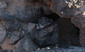
The Lava Tube Trail is shorter,  level, and leads to two lava tubes—which are places where the hardened surface fractures releasing the still molten magma inside to flow away. The remaining caves are sometimes big enough that you can crawl into and see where the bats and spiders live—I’ll pass. The above photo is the smaller tube, and visitors— braver than I—crawl into it.

Lava Grass - A small tuft of grass ekes out a living in barren basalt.
Lava Grass – A small tuft of grass ekes a living in barren basalt.

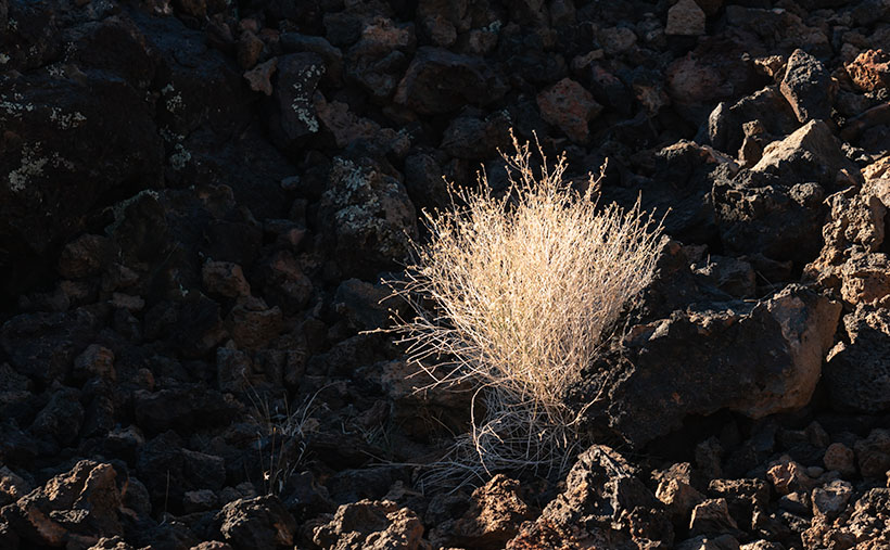
I find basalt a challenging subject to photograph. It’s like taking a picture of a black cat in a coal mine. To get any detail, you need to over-expose, which washes out the rich depth. Fortunately, and is the case with this week’s picture that I call Lava Grass, there’s enough green lichen growing on the rock to prevent the shadows from completely blocking up.

I feel lucky to have spotted the tuft of dried grass surviving in the barren rock. I concentrated hard on staying upright as I hiked the trail in the early morning. The jagged basalt is not skin-friendly and will likely draw blood if you fall on it. And—silly me—I left my bicycle helmet at home.

You can see a larger version of Lava Grass on its Web Page by clicking here. Next week we start a new year, with a new project in a new location. Be sure to come back and see where the road takes us.

Until next time — jw

Cottonwood Grove Picture of the Week

I want to begin this week’s post by thanking Deb Poteet for her advice about wearing fish-net stockings. If you missed what she said, it was a helpful comment to last week’s post. She said that she got her information straight from the Candy Store dancers—the gentlemen’s club on Cave Creek Road near Costco. It made both Queen Anne and me wonder what she was doing hanging around old strip clubs. Deb really does surprise us sometimes.

On another subject, Her Majesty is improving with each day. She goes to physical therapy three times a week and limps around the house without her walker or a cane. When I remind her that she doesn’t need to do that, she drops the Chester impersonation. It’s interesting to see how fast a woman can recover when you walk up to her death bed with a bottle of Dawn dish detergent and ask, “How much of this do I put in the dryer?”

Cottonwood Grove - A small grove of cottonwood grow along a dry brook in Peeples Valley, Arizona.
Cottonwood Grove – A small grove of cottonwood grows along a dry brook in Peeples Valley, Arizona.

Meanwhile, back up the mountain in Peeples Valley, and the second in my series of cottonwood tree images. This week’s featured image that I call Cottonwood Grove was another image taken on the Maughan Ranch north of town. Like other members of the Poplar family, these large fast-growing trees only grow where there’s a good water supply. In this image, there’s about a half dozen growing along the banks of a dry brook, which eventually feeds Kirkland Creek. Scenes like this one are familiar throughout the west.

In an Arizona Geography class that I took at Arizona State University, the professor told us how the trees filled the length of the Salt River bed. A family of beavers dammed the river under the Mill Avenue Bridge while the river still flowed. When the Corps of Engineers built the dams east of town, the Salt River stopped flowing, and the trees died, rotted, and eventually, a summer monsoon storm blew them over. That would have been a swell topic for a photo essay, but I wasn’t here then.

You can see a larger version of Cottonwood Grove on its Web Page by clicking here. I hope you like it. Be sure to come back next week for another cottonwood portrait from Peeples Valley.

Until next time — jw

Mount Tipton Wilderness Picture of the Week

Since our trip to Pearce Ferry, I’ve written about the Grand Wash Cliffs, and rightly so. Last week, I mentioned that they formed the western edge of the Colorado Plateau and that the great river bisects the cliffs. But the Hualapai Valley has another mountain range on its west flank, and they’re the Cerbat Mountains. They fill the 23 miles between Kingman and Dolan Springs. On the drive to Las Vegas on US 93, they’re to the east side of the highway as you travel north through the Detrital Valley.

There are some old mines located in the Cerbats; Cerbat, Mineral Park, and Chloride. Traveling north from Kingman, you first pass the ghost town of Cerbat, which is hidden at the end of a challenging (4wd) road. The next is Mineral Park, which is due east of Santa Clause (that’s another story unto itself). Finally, the biggest one is Chloride—whose tailings are visible from Highway 93. I think Chloride is still active, but I don’t know for what they’re digging.

Mt. Tipton Wilderness Area - The jagged peaks in the Mt. Tipton Wilderness Area are at the north end of the Cerbat Mountain Range.
Mt. Tipton Wilderness Area – The jagged peaks in the Mt. Tipton Wilderness Area is at the north end of the Cerbat Mountain Range.

More interesting to me is the Mount Tipton Wilderness Area, which is almost at the northern end of the Cerbat Range. At 7148 Mt. Tipton is the tallest peak, but the wilderness area also has some jagged peaks that made me stop to take this week’s featured image—even though the sun had gone behind the looming storm clouds. I named the photo Mt. Tipton Wilderness, and it shows dried grasses and creosote bush against the barren granite mountains.

On the whole, I enjoyed our drive to Pearce Ferry. There were a lot of beautiful sights found there, and I can see returning in the future to do more serious photography. That’s the downside of these trips. They’re to photography what Cliff Notes are to books. To get the best results, you need to study and understand the subject.

On the other hand, we’ve only begun to explore Arizona’s back roads, and there’s so much more to see. I feel like I wasted the first two-thirds of my adulthood working for a paycheck. However, I understand that I wouldn’t be here if I hadn’t. I hope I have enough time to finish it all.

You can see a larger version of Mt. Tipton Wilderness on its Web Page by clicking here. I hope you enjoy seeing it. Next week I have a surprise for you. Something completely different, so I hope we’ll see you then.

Until next time — jw