Mount Tipton Wilderness Picture of the Week

Since our trip to Pearce Ferry, I’ve written about the Grand Wash Cliffs, and rightly so. Last week, I mentioned that they formed the western edge of the Colorado Plateau and that the great river bisects the cliffs. But the Hualapai Valley has another mountain range on its west flank, and they’re the Cerbat Mountains. They fill the 23 miles between Kingman and Dolan Springs. On the drive to Las Vegas on US 93, they’re to the east side of the highway as you travel north through the Detrital Valley.

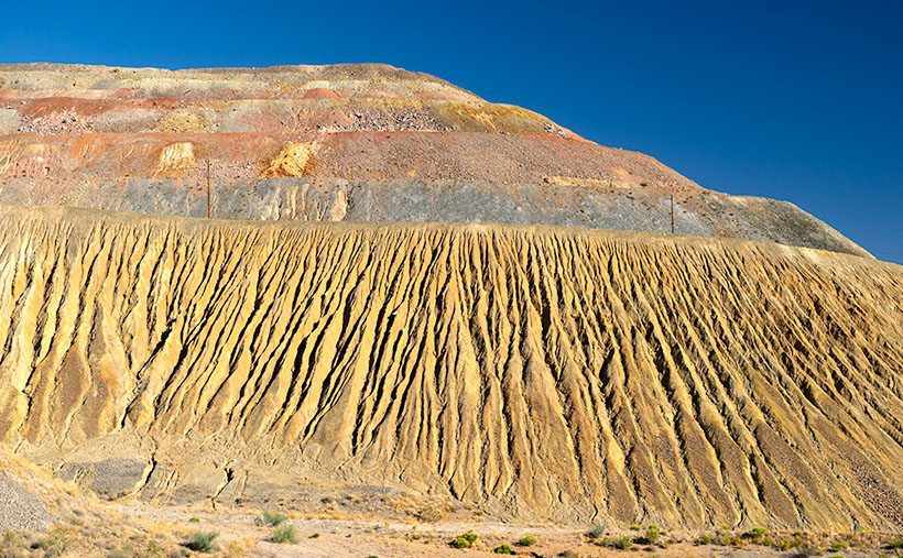
There are some old mines located in the Cerbats; Cerbat, Mineral Park, and Chloride. Traveling north from Kingman, you first pass the ghost town of Cerbat, which is hidden at the end of a challenging (4wd) road. The next is Mineral Park, which is due east of Santa Clause (that’s another story unto itself). Finally, the biggest one is Chloride—whose tailings are visible from Highway 93. I think Chloride is still active, but I don’t know for what they’re digging.

Mt. Tipton Wilderness Area - The jagged peaks in the Mt. Tipton Wilderness Area are at the north end of the Cerbat Mountain Range.
Mt. Tipton Wilderness Area – The jagged peaks in the Mt. Tipton Wilderness Area is at the north end of the Cerbat Mountain Range.

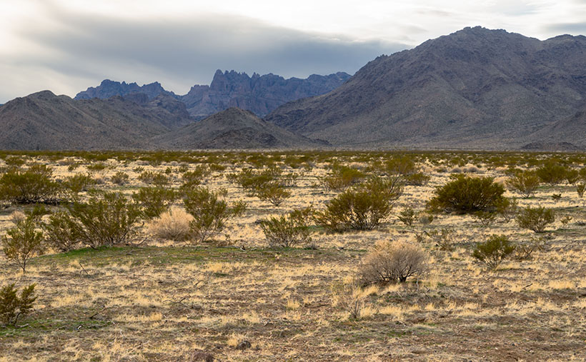
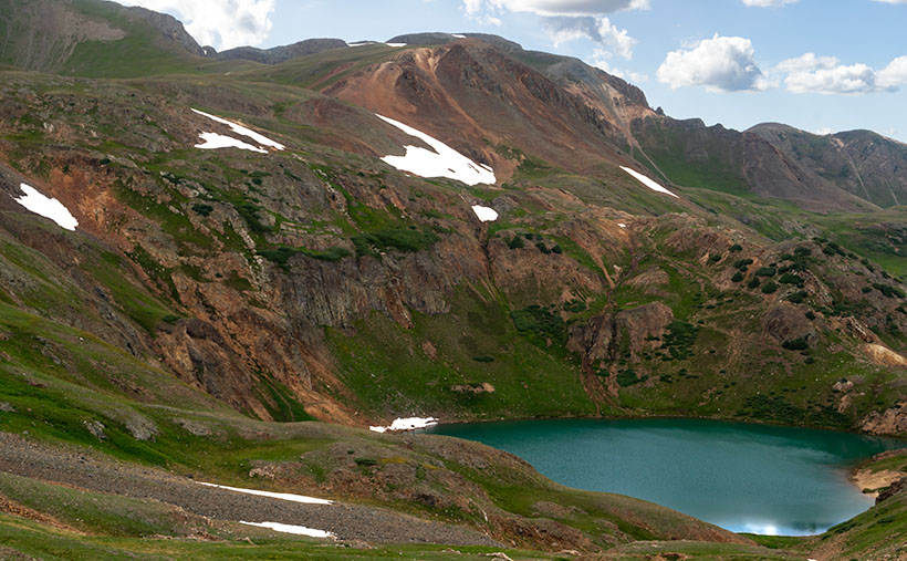
More interesting to me is the Mount Tipton Wilderness Area, which is almost at the northern end of the Cerbat Range. At 7148 Mt. Tipton is the tallest peak, but the wilderness area also has some jagged peaks that made me stop to take this week’s featured image—even though the sun had gone behind the looming storm clouds. I named the photo Mt. Tipton Wilderness, and it shows dried grasses and creosote bush against the barren granite mountains.

On the whole, I enjoyed our drive to Pearce Ferry. There were a lot of beautiful sights found there, and I can see returning in the future to do more serious photography. That’s the downside of these trips. They’re to photography what Cliff Notes are to books. To get the best results, you need to study and understand the subject.

On the other hand, we’ve only begun to explore Arizona’s back roads, and there’s so much more to see. I feel like I wasted the first two-thirds of my adulthood working for a paycheck. However, I understand that I wouldn’t be here if I hadn’t. I hope I have enough time to finish it all.

You can see a larger version of Mt. Tipton Wilderness on its Web Page by clicking here. I hope you enjoy seeing it. Next week I have a surprise for you. Something completely different, so I hope we’ll see you then.

Until next time — jw

Ray Tailings Picture of the Week

Queen Anne's directives - From her royal coach, Anne delights in pointing the way we should've gone.
Queen Anne’s directives – From her royal coach, Anne delights in pointing the way we should’ve gone.

Picking a new back road to explore, photograph, and talk about is easy for some months. I may have seen a place that piqued my curiosity, and I’m ready to go. Other months are hard. I’ll pour over my maps, hoping to find inspiration. This month was different. When Queen Anne told me that she wanted to visit an ex in Florence (1), I knew right away which trail we’d be talking about in November. Of course, we’d pick the Florence-Kelvin Highway.

The highway between Florence and Kelvin is a 34-mile shortcut between the towns. Although it’s 13 miles shorter, driving around the Tortilla Mountains and through Superior using the paved highways is faster. I’ve partially traveled this road before when I photographed the Cochran site—the ghost town where only the coke ovens remain. They paved sixteen miles of the highway between Florence and the Cochran Road. It’s a long gentle grade rising 1500 feet. Then it winds through the Tortilla Mountains, past a couple of ranches, before descending into Kelvin—a small community along the north bank of the Gila River. Although there may be some wash boarding between gradings, the dirt is broad and doesn’t require a particular vehicle.

On this trip, Anne and I drove east to west, so we’d be somewhat closer to home. From Congress, we drove two and one-half hours to Superior, and most of that time was spent getting to the other side of Phoenix. In Superior, we turned south on County Road 177 to Kelvin—a community so small it doesn’t even have a Dollar Store. Something that Kelvin does have is the Ray open-pit copper mine currently managed by the Mexican mining company, Asarco. And it’s where I photographed this week’s featured image that I call Ray Tailings.

Ray Tailings - A 500-foot tall inside out mountain of mine tailings.
Ray Tailings – A 500-foot tall inside out mountain of mine tailings.

This operation is so massive that you see it on the east side of the highway for a couple of miles. The central pit—Jimmie Luck Gulch—looks like it could be used to mold giant Devo hats (“Whip it good“). In the middle of the Dripping Spring Range, the mineworkers have dug a negative mountain with terraces that the behemoth trucks use to haul ore to the surface. Digging that much dirt out of the ground to remove the copper, you have to stack the sterile waste somewhere, and that’s what I photographed for this week’s issue. It’s the mountain stacked up—inside out. The minerals found beneath the surface colors each layer. To me, the 500-foot pile looks like a gay-pride wedding cake.

It’s an impressive bit of technology to see, but it also causes environmental problems. Because the rocks and dirt are devoid of nutrients, unless scientists intervene, it will take centuries for plants to colonize the tailings. So that makes them susceptible to accelerated erosion. With each heavy rain, bit by bit, the pile makes its way into the Gila River and eventually the Sea of Cortez. That’s not good for the downstream people who rely on the river for clean water (Arizona Copper Co. vs. Gillespie).

You can see a larger version of Ray Tailings on its Web Page by clicking here. I hope you enjoy viewing it. Next week, we’ll continue along the Florence-Kelvin Highway, and I’ll show some of the natural beauty we found there.

Until next time — jw

(1). For those of you that live in another state, or don’t get the joke, Florence is the location of Arizona’s State Prison. She doesn’t really know anyone incarcerated there, but that’s not as funny.

Lake Como Picture of the Week

Lake Como as seen from the top of Calaifornia Pass.Lake Como – A little alpine lake from California Pass in Colorado’s San Juan Mountains.

Something is intoxicating about standing on a mountaintop. You get a sense of accomplishment—an incredible buzz—while taking in the view. As you spot familiar landmarks, the map you carry around in your mind gets updated. I can understand the addition mountain climbers have to the highest peaks. I’m just too lazy to be one of them, and you won’t catch me on the climbing wall at the local gym—or inside the gym in the first place. Spending a day with Fred driving his FJ up-high passes in the San Juan Mountains was good enough for me.

When we decided not to spend all day driving Colorado’s Alpine Loop but drove up two of its passes, we wanted another challenge. The first ascent was scary, while the second was not so much. I felt like a kid on a swing urging his parents to push harder. “Again,” I shouted. So, we stood on Engineer Pass with the map spread over the hood, looking for another route back to Silverton. After all, we didn’t want to go back down the way we came. That was along the Animas River and was flat and dull. We agreed on a route that would take us over two more passes before dropping back to Silverton via Cement Creek, and that meant that we’d have first to drive back down to Animas Forks.

From the ghost town, we headed west up California Gulch. Going in this direction, the road ran straight ahead for several miles and appeared to end midway up California Mountain. Several times, I’ve traveled roads without a clue what’s ahead. For example, Interstate 15 is heading north out of Mesquite, Nevada. As it leads for the Beaver Mountains, you can’t pick out where the freeway climbs over them. I always involuntarily back out of the gas in case the road suddenly ends—like against the mountainside. At the very last moment, the Virgin River Gorge opens and swallows the highway. I was getting that feeling now.

It wasn’t until the perceived end of the road that it turned on itself and climbed behind a side ridge that hid the route from below, and as we drove around the bend, the trail went vertical. I questioned our decision to go this way because this was undoubtedly the beginning of the roller coaster from hell. Fred managed to keep all four wheels on the ground while his truck grunted its way up the grade. When we reached the top, as with the other passes, there was a spot to park and look around. When I got out, I decided a box of Depends would be a handy accouterment on these trips.

But the view! The light was coming in, and there were great shots back at California Gulch, and in front was this pretty little alpine lake—Lake Como—on the other side. I have seen pictures of places like these in magazines, but I’ve never been to one. It was breathtaking—well, 13,000 feet is stunning enough, but you know what I mean. I snapped several variations of this photo, and we eventually drove down to the lake where Fred tried to park over an open mine shaft, but that’s another story. This week’s featured image is the version I liked best because of its composition and color details. I call it Lake Como. I hope you like it.

Don’t let your eyes miss out—feast them on an even grander version of Lake Como right here (Jim’s Page)! Buckle up because we’re diving back into Colorado’s enigmatic San Juan Mountains aboard Fred’s Toyota next week. Trust me, you won’t want to miss this!

Until next time — jw

Mine Tailings Picture of the Week

With this posting, we’ve completed this month’s photo excursion of Castle Hot Springs Road. The detour north of State Route 74 started with almost prairie-like flat desert adjacent to the Wickenburg range. Then the road ascended into the Buckhorn Range with a magnificent view of the Bradshaw’s. Next, our back road dropped down to Castle Creek through the Hieroglyphic Mountains past the hot springs resort. Finally, we returned to asphalt at Lake Pleasant where we saw vast groves of saguaros growing on the mountain slopes (I put that in my mental filing cabinet for a future outing).

There was one scene along the way that wasn’t quite ripe enough to shoot when I first drove by it, so I wanted to backtrack and see if it improved with the warm afternoon sun. It did, and it is this week’s featured image which I call Mine Tailings.

Mine Tailings - Tailings comprised of red soil caught my eye because of the color and erosion pattern.
Mine Tailings – Tailings comprised of red soil caught my eye because of the color and erosion pattern.

I don’t know if there are an inordinate number of mines in Yavapai County, but it seems like they’re everywhere. A few hearty souls—that either suffer from unrelenting gold fever or have nothing better to do—still work the claims, but most of the mines are abandoned. When the ore runs dry, the prospectors move on in search of the next elusive bonanza. Because there’s no economic incentive to restore the claim, abandoned mines are left unposted and are often dangerous. Just this year, rescuers have pulled a couple of people trapped in mine shafts. It’s a growing Arizona problem.

One of the tells of an old mine is the tailings. As prospectors tunnel into a mountainside, they have to remove the diggings and pile them somewhere. In massive operations, fleets of trucks build hundred-foot-tall dikes, like the one that used to line Highway 60 in Miami, Arizona. But with smaller claims of one or two men, they will fill a wheelbarrow and walk it outside and dump it over the edge, building a tailings dump; the deeper the mine, the bigger the tailings.

The thing that makes the tailings in this week’s photo interesting to me is that they’re red, and the late afternoon sun exaggerates that color. The red against the blue sky vibrates my eyeballs. There’s more that we can learn from the image, like how old it is. The erosion patterns are deep from many seasons of heavy rain, and its fan pattern is reminiscent of what you see in the Painted Desert. In both cases, water easily cut through soft soil. Finally, dirt and rock that comes out of a shaft is well below the topsoil level, so it’s not rich in nutrients. Here, the desert Mesquite has begun to colonize the hillside, so the soil contains some organic material already.

You can see a larger version of Mine Tailings on its Web Page by clicking here. Be sure to come back next week when we set off for another adventure exploring Arizona’s back roads.

Until next time — jw

Rock Frog Picture of the Week

Frog Rock
Frog Rock—The pile of boulders painted to resemble a frog has been a Congress landmark since 1928.

Our adopted town of Congress is a quiet retirement community these days, but it wasn’t always this sleepy. Like most of the old mining towns in Arizona, Congress was a bustling hive of activity as long as gold poured out of the ground. At its peak, the town had more people than a dusty farming village called Phoenix. But when the gold ran out, so did the reason to stick around. The land here is too rocky to farm, and there isn’t much to see—unless you’re a fan of large green amphibians.

Yes, Frog Rock puts Congress on the map. It’s not just any pile of boulders; it’s a pile of boulders that has been painted to look like a giant frog since 1928. I like to imagine that this oddball landmark sprang from the mind of Sarah Perkins, a homesteader’s wife who was bored out of her mind.

Picture a sweltering summer afternoon in 1928. Sarah is rocking on her front porch, the oppressive heat pressing down like a wet blanket. She’s sipping lukewarm lemonade and staring at the same pile of rocks she’s stared at every day for the last decade. Across the road runs US89, the main highway through town—a lifeline of commerce and travel. “Lester,” she says, her voice dripping with determination, “next time you’re in town, bring me some green paint.”

Lester, who’d been married long enough to know better than to question Sarah’s whims, nodded without so much as a grunt of inquiry. Weeks later, when he returned from Wickenburg with supplies in their rickety Model A pickup, Sarah found two cans of green paint and three sturdy brushes buried among the flour and beans.

The following day, before the heat became unbearable, Sarah gathered her sons and marched them across the road to the pile of boulders. With the determination of Michelangelo tackling the Sistine Chapel, they slapped on layer after layer of green paint. By noon, the Perkins family had created a masterpiece: a giant rock frog that gazed serenely at passing Model Ts.

Over the years, Frog Rock has become Congress’s pride and joy, our version of the world’s largest ball of twine or the giant ketchup bottle. Sure, it’s kitschy, but it’s our kitschy. When the paint fades, a self-appointed committee—armed with more enthusiasm than skill—ensures Frog Rock gets a fresh coat. On their last go-round, they even added spots to its back for extra flair.

Today, that highway is known as Arizona State Route 89, a quieter and more scenic version of its old self. Locals call it The Lost 89, a stretch of road that seems to have slipped out of time. Frog Rock has kept watch over it all through the rise and fall of mining, the rerouting of highways, and the inevitable march of progress.

When I decided to photograph Frog Rock, I wanted to capture more than just the green paint job. I wanted to show how the massive granite boulder fits into its rugged desert surroundings, so I framed it with other rocks in the foreground. The result is a tribute to Sarah’s imagination and Congress’s ability to find joy in the simple things.

If you’re ever passing through town, stop by and say hello to Frog Rock. Don’t be surprised if you feel inspired to grab a brush and add your artistic touch. After all, in Congress, anything is possible—even turning a pile of rocks into a legacy.

Until next time — jw