When I was roaming around Black Canyon City a couple of weeks ago, I was on a street with homes along the right side and open land on the other. On the hillside was a dense stand of saguaro growing, and I knew I wanted to capture their image, but the field had a barbed wire fence. As I drove further down the street, I found an open spot. A gravel road led onto the property, so I parked the truck and got out for a closer look.
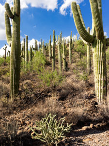
Saguaro Grove – these giant cacti grow exceptionally well on south-facing, well-drained slopes.
I’m usually cautious about trespassing, so I always look for Keep Out signs. After all, this is Arizona, and I’m allergic to bullets. I saw no postings nearby, but a sign was down the road. It read, “Agua Fria National Monument.” I thought, “There’s a national monument? Here, this close to Phoenix? Why don’t I know about this?” All the open areas from Black Canyon City to Cordes Lakes and east of Interstate 17 were given monument status in 2000 because the Agua Fria River is a treasure of ancient dwellings, petroglyphs, and artifacts. There are no freeway signs, visitor centers, or entrance fees. There is a hiking trail that runs its length, and you can walk, bike, or ride horseback. Bloody Basin Road cuts through the monument; from it, you can access a couple of rugged jeep trails. So, I’ve already mentally filed it away as a future project.
Meanwhile, back at Black Canyon City …
Saguaro grows exceptionally well on well-drained south-facing slopes, so when you see a grove like this, you can tell the compass direction—like moss on the north side of trees. The overhead clouds are remnants of Hurricane Rosa, which dumped enough rain to plump up these giant cacti. They look like my uncle making his way to the couch after Thanksgiving dinner. I could have titled the image with a snarky name, but I didn’t. It’s merely titled Saguaro Grove.
You can see a larger version of Saguaro Grove on its Web Page by clicking here. I hope you enjoy viewing this week’s post and return next week when we show another featured image from Black Canyon City.
By now, you know that I’m a history buff—or perhaps I’m only interested in trivia. I don’t see the distinction, but I know I’m not cut out to be a scholar. I don’t have the patience to spend months in the Vatican Library tracing the origins of … anything. If Google or Wikipedia doesn’t explain, I move on. However, if someone mentions Hannibal, I think of elephants, not fava beans. I even watched all the James Burke’s Connections series—twice. I’m the only person that I know who has a personal copy of Arizona Place Names—and uses it. This probably explains why I write blog posts instead of novels, and it is the reason behind this thought I had when I published this week’s image—I wonder how many young people know the history of the sidewalk’s stamp.
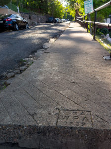
While scurrying up and down Jerome’s hilly streets last week, I went into the Holy Family Catholic Church on Country Road for an interior shot. After that, because the day was late and I was out of breath, I returned to Main Street, where Queen Anne awaited me. A few stairs were at the end of the street, so I looked down to prevent falling. That’s when I first saw the stamping and decided that I needed to take another photograph. I call it WPA Sidewalk.
This section of sidewalk in Jerome is a museum piece that people walk on daily.
This is only the second existing example of a Works Progress Administration—renamed in 1939 as the Works Project Administration; it was the depression era program that employed people for public works projects—that I have cataloged in my brain’s world map. The other is a bridge on the US89 north of Flagstaff. (Maybe finding and shooting WPA sites would be a book-worthy photography project.) Jerome has already replaced many of its walkways with ADA-compliant versions. They had to because of age, winter freezing, and earth movement, but this one is still in good shape and used daily. With the hand-scribed lines (for better footing?), it’s certainly different from the sterile versions that machines spit out today. Since it’s over fifty years old, it probably qualifies for protection under the American Antiquities Act. This sidewalk is the only museum piece I know you can leisurely stroll down.
You can see a larger version of WPA Sidewalk on its Web Page by clicking here. I hope you enjoy viewing my newest entry and return next week when I post another Jerome photograph.
My lovely bride abandoned me for a couple of days to get her annual check-up at a beauty spa on the Arizona Rivera—Lake Havasu City. Before she climbed into her friend—Yasmeen’s—car, she turned to me and with a pointed finger and sternly said, “I have two words for you. Be – have!” Well … that sounded like a challenge to me, so I began thinking about what kind of trouble I could get into. I was in the mood for a photography outing and I hadn’t been to Stanton since Fred and I got lost, so I tossed my gear into the truck and set off to get some new photos.
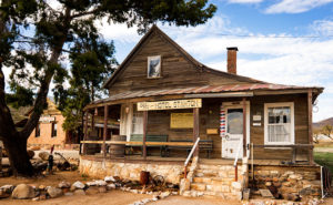
Hotel Stanton – During the Summer of Love, hippies moved in and set up a commune. Unfortunately, they tore down many of the old buildings for firewood. LDMA has slowly repaired the remaining structures since acquiring the town in 1976.
Stanton is one of the many towns in mountainous Yavapai County (rhymes with have-a-pie) where, because someone discovered gold, a town sprung up overnight and disappeared just as quickly when the ore played out. It was little more than a stagecoach stop on the Wickenburg-Prescott road at Antelope Creek until a tracker named Alvaro chased an errant burro to the top of what is now Rich Hill. When he got back to camp and told the expedition leader—Pauline Weaver—about finding gold nuggets “the size of potatoes” on the summit, you can surely guess what happened next.
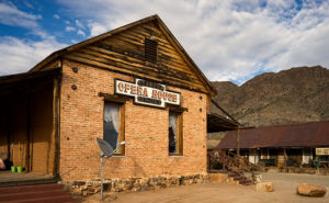
Opera House – The Opera House is an adobe building with a brick façade. It’s now used as a meeting hall for the RV Park.
The town—known at the time as Antelope Station—got its name from an unscrupulous character named Chuck Stanton who moved to the thriving community several years later. Stanton opened a store and, with the help of his hired banditos, killed off his competition. His reign didn’t last very long as he was shot and killed that same year (living with swords, I guess). The town thrived afterward for several decades but it had a bad reputation. “In 1892, for example, a Prescott newspaper reported that the residents of Stanton liked to ‘drink blood, eat fried rattlesnakes and fight mountain lions’” (Wikipedia). By 1905 the gold ran out and Stanton was abandoned.
Stanton Homes – Only three houses have survived the years of abandonment. They line a street surrounded by campers.
Ownership has changed several times since then and now it belongs to Lost Dutchman’s Mining Association (LMDA) and they have turned it into a member’s only RV Park. Membership is kind of pricey but LDMA has methodically bought up mining claims in the area and its members can work those old claims without charge. It’s surprising how many people will pay good money to play in the dirt—I don’t even like to plant flowers. Guests are allowed to visit but they first have to stop by the office and sign a release.
After my visit this week, I drove further down the road to the old Octave and Weaver mine sites and saw people on either side of the road prospecting. Late in the day, I stopped to take a photo along the roadside at quitting time when several trucks pulled out of a side road. They all slowed and waved and one of the men stopped to ask if I was getting some good shots. I asked him how his day went.
“What do you mean?” he asked.
“Did you make a fortune today,” I explained.
He laughed and replied, “Only the boss makes any money.”
“I see.”
Then he started telling an old joke, “Do you know how to make a small fortune in placer mining?”
“Yeah, you start with a big fortune,” I responded.
With that, he laughed and drove off in a big trail of dust.
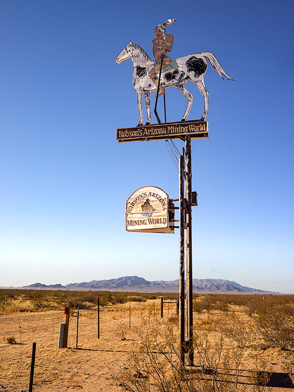
Robson Mining World Sign – The entrance to Robson Mining World is bullet-riddled Yavapai Apache riding a pinto.
I grew up during the era of the TV cowboy. After dinner, my family would gather in the living room and watch shows like Gunsmoke, The Rifleman,Maverick, and Have Gun—Will Travel to name a few. My dad was a tyrant about the shows we watched and we kids were the remote. Maybe that’s the reason I—and perhaps all my generation—have a fascination with ghost towns. We grew up with Tombstone, Dodge, and Virginia City on our TVs, and vowed to visit them one day. Maybe we’re longing for a simpler time—when the good guy wore a white hat.
The ghost towns best known in Arizona are Jerome, Tombstone, and my favorite, Bisbee. All of these places have residents, so they’re not as much a ghost town as they are tourist traps. A mining town’s fortune is dependent on the mineral wealth removed from the ground. The town’s size correlates perfectly with the amount of ore; be it gold, silver or copper. As soon as the ore plays out, people move on to the next bonanza leaving the hovels and shacks they occupied behind. Without maintenance, those relics soon rot or they’re repurposed for sheds, outhouses, or worst of all, firewood. Most often, when you visit a ghost town, the only things you find are a slab or wall. There’s not much interesting left to photograph. Fortunately, there are exceptions where a state or county government acquired and preserved the scene as a park, such as Bodie and Calico in California.
Yavapai County, where Queen Anne and I live, has its share of Ghost Towns—including Jerome—the most famous. Most of the old sites are high in the Bradshaw Mountains, but mining towns are scattered throughout all the Yavapai mountain ranges; including Congress—our hometown. It wasn’t until we moved here a couple of years ago that I learned about the best ghost town ever, and it’s a mere fifteen miles down the road tucked into the south-eastern flank of the Harcuvar Range.
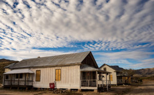
Travel west on Highway US 60 and Aguila is the first small farm community you’ll come to. The name is Spanish for Eagle derived from the eagle-shaped window in the low mountain overlooking the town’s cemetery. The western terminus of Arizona State Route 71 is a mile east of Aguila, and that’s the short-cut you take if you’re heading northeast to Congress or Prescott from California. Just before the road crosses the Maricopa-Yavapai County line is a sign with a bullet-riddled Indian riding a pinto horse. The sign is for Robson’s Mining World—the ghost town you can see at the mountain base. It’s a mining town that no one ever lived in, but has an interesting story nevertheless.
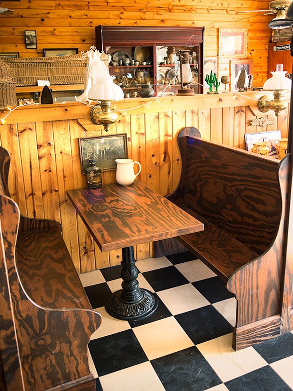
Robson Ranch Booth – When you enter the town’s soda parlor, you’d expect to order a milkshake. You’d be disappointed because it’s all for a show.
The gold mine at the end of the trail was first claimed in 1917 by Westley Rush, an Aguila melon farmer. Rush’s two daughters—Nella and Alameda, for whom the Nella-Meda gold mine was named—managed to hand dig through the first 115 feet of solid rock before Ned Creighton—a Phoenix banker—bought the claim in 1924. Ned hired a crew to work the mine, and over decades he expanded the claim to its present size. His crew worked until World War II when the Feds shut down all private mines. The mining engineer, Harold Mason, stayed on as caretaker and eventually got the property deed after Ned passed.
After the war, Charles Robson was building his fortune by farming, running the Saguaro motel in Aguila, and hustling the health benefits of his local bee pollen. Harold and Charley became acquaintances when Mason let Robson place hives at the mine. There were minerals around the mine that made the bee pollen exceptional and the bees deterred poachers. That informal partnership lasted until 1979 when Charlie bought the mine from the aging Mason. Robson had bigger plans for the place.
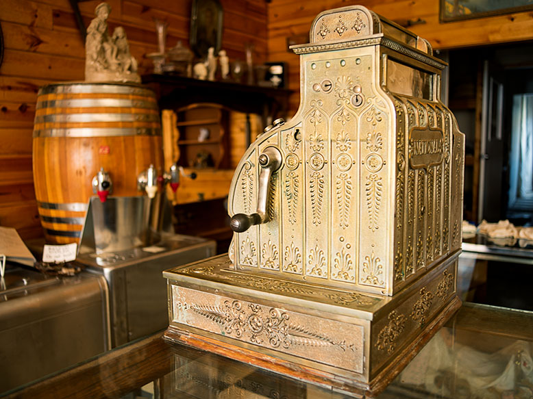
Cash Register – What this old cash register lacks in functionality, it makes up for with class.
Meanwhile, in 1922, Wilber T. Johnson migrated from Missouri to Apache Junction—a community east of Phoenix at the foot of the Superstition Mountains—so he could work in the mines. In 1930, Wilber traded his pick and shovel for an engineering degree from the University of Arizona which made him a highly valued employee. Now we’d call Wilber a hoarder because he collected mine junk—lots of mine junk—for the next fifty years. Johnson got his stash from abandoned mines in the Superstition Mountains, the Mazatzal Mountains, and other mines east of Phoenix and because of its size, his collection wasn’t a big secret. He reputedly turned down a multi-million-dollar offer from Disneyland Tokyo because he knew that they cherry pick the best and discard the rest.
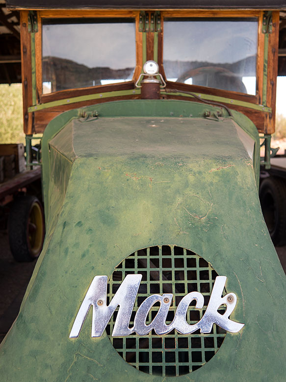
Mack Truck – A classic truck that miners used to haul stuff.
After Charles Robson acquired the mine, he offered to buy Wilber’s collection and the two men finally struck a deal when Charlie promised that the collection would stay intact on Robson’s property. The ink on the signatures hadn’t dried yet before more than 250 truckloads moved decades of mining history to its new home. For ten years Charles, his wife, Jeri, and their sons reassembled the buildings and filled them with the collection’s artifacts. After Charlie died in 2002, Jeri carried on the dream, and toward the end of her life sold the place lock, stock, and barrel to Western Destinations Corporation—the present owners—on the stipulation that nothing ever leaves the property.
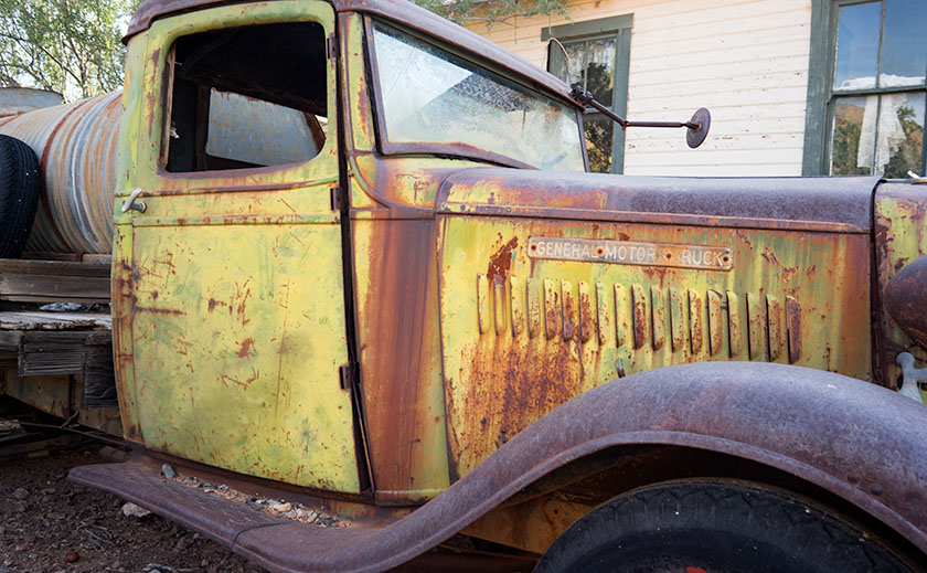
Water Truck – A GMC truck that was used to haul water up from the well to the mine.
There’s a small garden in front of the Opera House where we sat in a mesquite tree’s shade as Brett Bishop told me this story. He’s the current caretaker and he and his family live on site. He’s a young man, and when he’s not greeting visitors he keeps busy unpacking the remaining crates and creatively arranging the contents for display. It’s easy to tell—from the tone of his voice and the sparkle in his eyes—that he loves his job. He calls Robson’s a living museum and he often must unravel the mystery of the items he finds in the boxes.
If you’re a photographer interested in nostalgia, I highly recommend a visit. The cost is $20.00 per person which goes toward upkeep. Don’t count on food or entertainment and even the restrooms are period authentic—that’s right; crescent moons. The mile-long dirt road is navigable by a sedan, except after heavy rains. I know that Robson’s will become one of my resources.
I am a reluctant traveler. When Linda — my wife — suggested we go to Serbia this year to join my son and his family on vacation, I was more reluctant. Then she said we would also be spending ten days on a Greek island visiting new beaches every day during the middle of our visit to Belgrade. That’s when I reluctantly agreed.
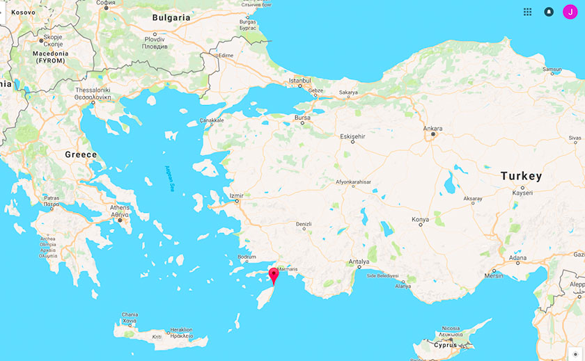
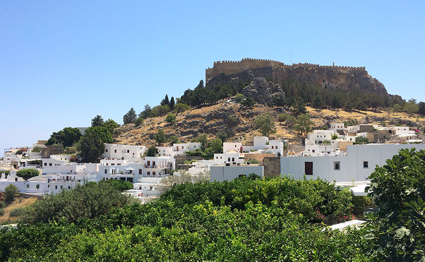
The island of Rhodes is closer to Turkey than Greece.
My wife, my son, Nathan, his wife, Nela, and their three-year-old son, Matija and I took a ten-day diversion trip from Serbia to see Rhodes. This was one of the best vacations I have ever been on. We booked a package tour that included the flight from Belgrade, ground transportation, and ten days at a hotel with what’s called “half board”. That means the price included breakfast and dinner and we were free each day to explore the island for good places to eat lunch
I am barely off the plane and I am already awestruck by the history of this island! Most of us are familiar with the Colossus of Rhodes, the giant statue that stood at the mouth of Rhodes harbor, and one of the wonders of the ancient world, built in 280 B.C. Historians estimate the statue was as tall as the Statue of Liberty. An earthquake destroyed it in 226 B.C. and the harbor it overlooked has a “new” lighthouse built quite recently (1412 A.D.).
The whole north and east coasts of Rhodes have become a resort Mecca on the Mediterranean Sea. The west coast is on the Aegean Sea. It’s windier and has more waves, so all the resorts are on the east side of the island. The water on that side is calm, clear, and warm enough for even us Southerners to enjoy. All beaches have chairs and ‘sunbrellas’ to rent, and most have kayaks or motor boats to rent, and some even offer parasailing. Our hotel was in a small town called Faliraki. The town’s main attraction is a long, wonderful beach with sand that felt like velvet under our bare feet.
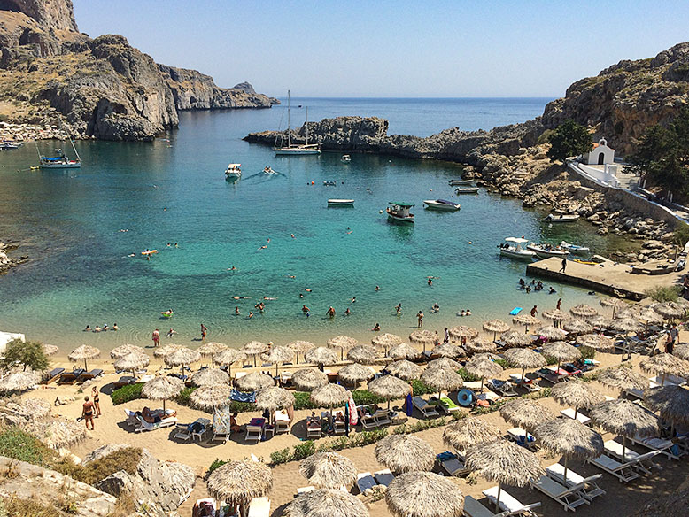
This was my favorite beach and it typifies the beaches there. The white chapel on the right is dedicated to Saint Paul in honor of his 3rd missionary journey. You can see how clear the water is!
We shared a rented car with another family and used it to explore the island’s beaches and attractions. Every other day we would drive to a new beach, eat at new Tavernas (as they call them in Greece), and explore new fortresses. One day we visited Lindos, a famous town with a huge fortification at the top of the hill, but found we could not get to the beach easily with our bags and grandson. Just around the corner, however, was another called Saint Paul Beach — my favorite of the trip. There was a scuba diving school, good food, excellent beach sand, and we could swim out to a rock and jump from it. We walked over to a small white chapel to see it up close, and we saw a plaque that explained the bay’s name; it said Saint Paul visited here on his Third Missionary Journey as he returned to Jerusalem. The island’s incredible history came at us like waves all week.
The town of Lindos with the restored fortress at the top of the hill. The Knights of Saint John built the fortress after the Crusades.
Speaking of waves, there weren’t any. No tide either. This made for some very clear water and we realized it was perfectly safe to let the three-year-old play in the water without fear of him being dashed to bits by surprise wave action. Swimming was wonderful and the snorkeling was some of the best I have seen. The weather in July was incredible with blue skies every day, nice breezes to keep us comfortable, and temperatures in the mid-80s. One day there was a cloud and we all stopped to marvel at it; that’s how good the climate is there.
Everyone we met was friendly and almost no one was American. Along the coastline, nearly all the folks in shops and restaurants spoke enough English that communication was simple. We did take a couple of trips to remote areas of the island where English was not spoken, but we quickly learned to point and grunt to make our needs known. The real Greek food was delicious and they press olive oil right on the island. All the dining was al fresco and most places where we stopped had good Wi-Fi so we could update our messages and stare at our phones like true Americans. My only complaint about Rhodes (and most of Europe really) is they still allow smoking in restaurants and even seem to encourage it with ash trays on all the tables. Make sure to get an up wind table!
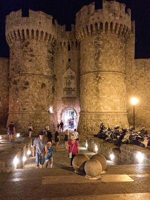
This is one of the gates to the ancient walled city of Rhodes. Just across the street behind where I took this photo, is the ancient harbor where the Colossus once stood.
I have gotten this far in the telling and have not mentioned the old, walled city of Rhodes. Oh, my! The history there is worth its own narrative. We spent a day visiting the shops, eating gelato, looking in at several restaurants, touring the old walls and bridges, walking down narrow alleys and passageways; did I mention the gelato yet? One of my hobbies is geocaching — an outdoor treasure hunting game using GPS enabled devices — so I took some time and found all the caches in the city. It led me to places I would never have seen otherwise.
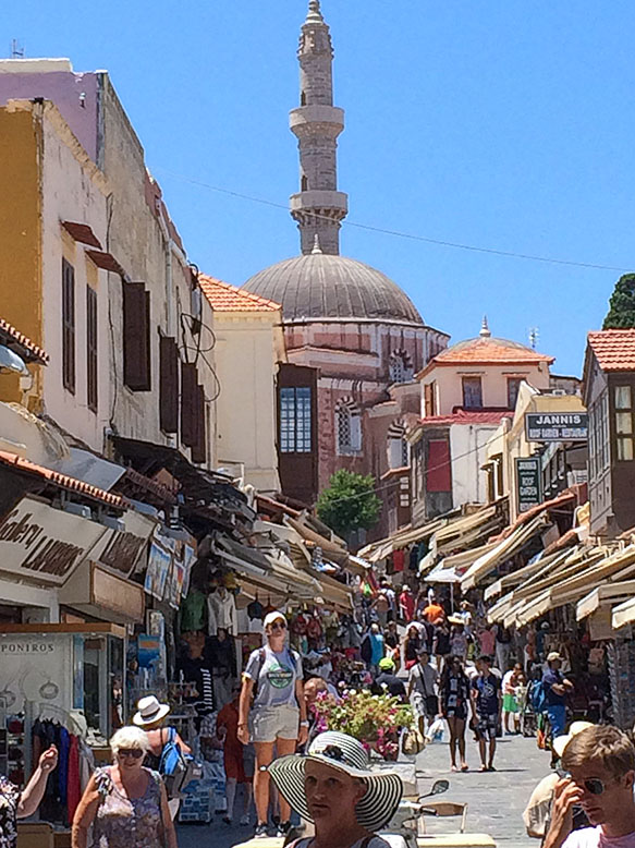
The new city of Rhodes surrounds the walled city but it still exists and is vibrant and alive. This is the main shopping street which runs through the city; one side to the other.
I wish I could adequately convey the sense of awe and wonder we all felt at seeing the ancient and modern artifacts on the island. I would go back tomorrow if I could and I am so grateful to my wife for cajoling me into going this summer. Perhaps I won’t be such a reluctant traveler in the future.
Don
Don is Queen Anne’s older brother and he and his wife live in Charlotte, North Carolina. I’m pleased that they shared this story and pictures with us and I thank him for contributing to our blog. – jw
In the spring of 1959, my dad traded in his ’52 Ford Business Coupé for a brand new Ford station wagon. It was two-tone — white over red — with red vinyl seats, push button radio and 4-60 air conditioning — you’d roll all four windows down at 60 miles an hour for greatest effect. Neither my three sisters nor I had a clue why he bought the new car. His pride and joy was the ’56 Crown Victoria that was in the garage. We didn’t need a reason, and we didn’t care. It was new and shiny and had pretty wide white walls. As we found out later, he bought it so we could visit his uncle in California. The six of us were taking a two-week road trip from Pittsburgh to LA and back. We were the Griswolds prototype.
When my dad was behind the wheel, he focused on the destination. I don’t think the man would have stopped for a bathroom break had not one of us been whining from the back. We started out on Friday evening, and drove all night to Chicago, but not stopping until the next evening in Joplin. Mom may have done a stint, but we were asleep in the back.
We were on Route 66, The Mother Road. We didn’t appreciate its significance then, the TV show wouldn’t air for another year and we were too busy making truckers honk their air horns. My dad was relentless, he wouldn’t stop to see the Jackalope, the Thing, the Grand Canyon, or any of the other cool places that cost time and money. Can you imagine torturing kids like that? Signs along the road … “The Thing – 50 miles”, “The Thing – 10 miles”, 5, 4, 3, etc. At least he didn’t stop the car to kill us. Of course, that would have meant stopping the car.
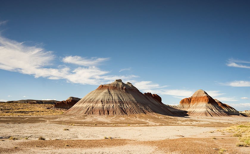
A pair of Chinle Shale formations showing the different colored layers of volcanic ash.
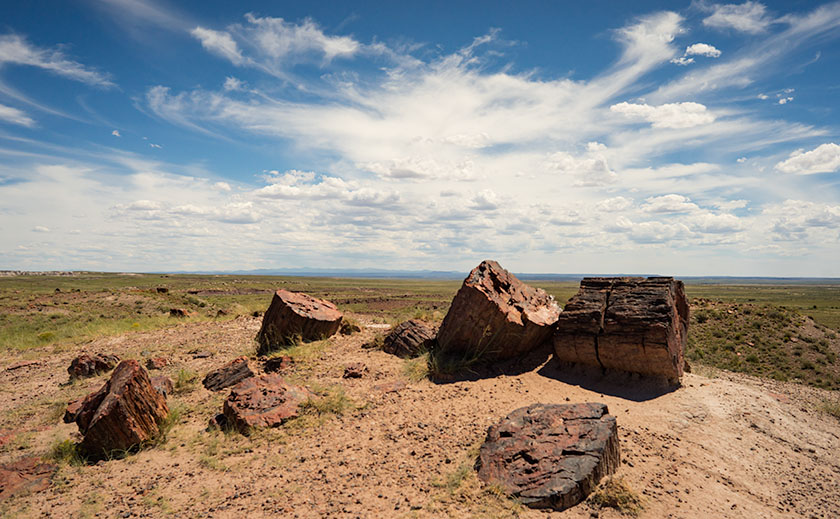
He did stop at one place — The Petrified Forest — he had to. The stupid road ran right through it. He said we could stop and go through the park and we were giddy. Finally, we’d see something and maybe get a break from the treeless desert we drove through. A forest, with trees; made from rocks … yeah! Imagine our shock when we saw all the rock-trees were knocked over. This wasn’t a respite from the desert, this was just more desert … with cool looking rocks. “There’s so many of them, can I take just one mom … huh? … huh? … Can I?” Even now, I sound so annoying, I want to slap myself.
The stops along the park road show off the park’s best. This is the Large Trees exhibit.
Within a month of our return from that vacation, my parents sold our Monroeville house and the second car. They got rid of most of our excess baggage and we moved to California. We settled into a Sylmar rental house so quickly that none of us kids missed a day of school. Although our family drove along Route 66 four more times, we never again stopped at the Petrified Forest. After I moved to Arizona decades later, I made two photography outings to the park on my own.
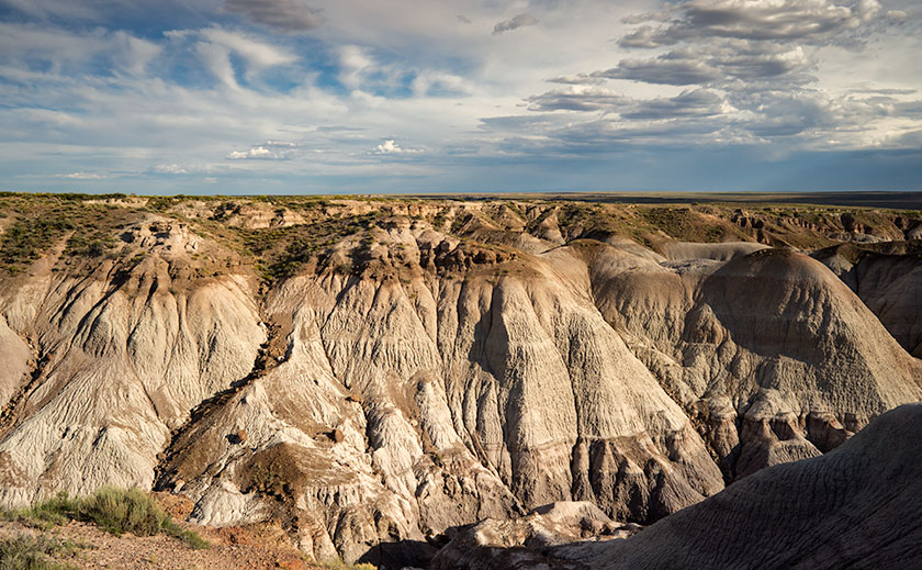
My favorite part of the park is Blue Mesa with its maze of Chinle Shale erosion.
Yesterday, I took Queen Anne to visit the park for her first visit. Despite what Google Maps says, it’s only an hour trip along U.S. Route 180. The road follows the Little Colorado as the river descends from the grass-covered Springerville Volcanic Fields, past the little town of Saint Johns where the cinder cones give way to dirty tan sandstone. The red silt river played hide and seek, only revealing itself when it passed under the empty highway. As the elevation continued to drop, the sandstone formed low tables and — where water eroded the softer underlying shale — large angular blocks broke off and slumped on the red soil below. Further along, I saw a bright white swell that I guessed was Chinle Shale and I knew we were almost there.
When we visit a national park, we head straight to the visitor center. That’s where you learn stuff … besides, I love those giant relief maps — which they didn’t have here. This time, we sat through the documentary film, browsed the museum exhibits, picked up some pamphlets, and bought two photo books before driving north along the road. As a photographer, I want to see the ‘long-shot’ first, so we slowly drove the road’s length. I made mental notes as we went, and tried to figure out how I’d shoot those images after the crowd thinned. After we turned around, we stopped at each pull-out, walked the trails, and photographed what we saw. As the day passed, I watched how the light and the sky changed as clouds formed over the White Mountains and the San Francisco Peaks before they drifted away in the invisible air stream.
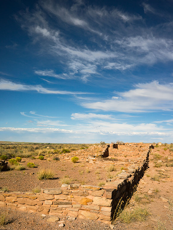
Along the bank of the Puerco River, a Pueblo ruin can be explored at leisure.
We discovered that the park isn’t just about petrified trees, it’s about layers. There are layers of soil and rocks, layers of flora and fauna, and layers of settlers and travelers for everyone to see in an open time capsule. As each rainy season washes away soil, more fossils are uncovered. There are fossils of ferns, grasses, lizards, crocodiles, toads, dinosaurs … and yes, trees. People before us settled this land, and they’ve left things behind for us to find. They left arrowheads, baskets, weaving, petroglyphs, and along the bank of the Puerco River, a pueblo ruin. Other people have traveled through the park. The Mogollon’s had trade routes to and from the Pueblos in New Mexico. In 1853, Lt. Amiel Weeks Whipple used those trails to survey the route now used by Burlington Northern Santa Fé Railroad. The tracks were a basis for U.S. Route 66 and now Interstate 40. These routes are layer upon layer of traders and countless migrants moving across the Colorado Plateau.
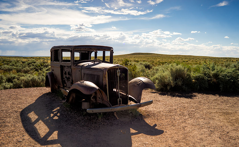
To commemorate the famous highway, the park service placed a 1932 Studebaker shell at the place where the highway and park road crossed.
Even though the National Park’s mission is to preserve and protect natural history, I was pleasantly surprised to see a nod to history more recent. There’s a turn-out north of the Interstate 40 bridge marked by a rusty skeleton of a 1932 Studebaker on blocks. It’s the spot where Route 66 passed through the park. The pavement has returned to grass and sage, and only the telephone poles give away the road’s alignment. The road of my past. While I was photographing the scene, I swore I heard distant echoes of four kids in a red and white station wagon, begging dad to stop.
One of the things tourists do upon arrival is to visit the city park. I don’t know why, but when you browse the brochures, the local park is usually at the top of the list of to-do things. For example, San Francisco has the Golden Gate Park, there’s Central Park in New York, and Griffith Park in Los Angeles. Phoenix has the Margaret T. Hance Deck Park, but I don’t think anyone has ever gone there. These are open spaces within the city that their leaders felt important to protect from development. Springerville has Casa Malpais which isn’t really a park in the traditional sense of the word, but rather a fourteen acre archaeological preserve that the city owns and maintains. In other words, it’s a Pueblo Indian ruins.
Listed on the National Register of Historic Places since 1966, Casa Malpais was built on a basalt ledge overlooking the Little Colorado River a couple of miles north of Springerville. The Mogollon people lived there from 1250 to 1350, before abandoning the site. Frank Cushing was the first European Archeologist to visit the Pueblo in the 1800s and the University of Arizona did partial excavations a hundred years later. The findings of that dig are on display at the museum on Main Street back in town.
Queen Anne and I wanted to see Casa Malpais yesterday, so we stopped by the museum to get directions. We found out that the pueblo is not open for self guided tours, but guides take visitors out to the site three times daily. Since it only cost $10.00 per person ($8.00 for geezers), we signed up for the next bus. As we waited for our tour, we watched a twenty-minute background film that explained the history and what to expect. The museum hosts made sure we had sturdy shoes, sun block and water before we left. At 1:00 we (just the two of us) boarded the shuttle for what was a private tour. After making sure we had all of our gear, Phil, our guide drove us to the scene.
When we arrived we got off the bus and I slung my camera bag over my shoulder while Anne threw some water in her purse/backpack thingy. Phil asked if we didn’t want to take a walking stick, so we each grabbed one from the rack. Looking up at the cliff, I thought, “This will be fun.” I didn’t see an obvious way to get up there. After we were ready, Phil explained, “The trial over there used to be the only one until the archaeologist brought a drone to film the site a couple of years ago. After studying the films, they realized that there was a second path up the ledge, so we’re going to go up this way and come down on the old trail.” I wondered what he was talking about, I couldn’t see a trail in front of us much less the one over there. While we’re at it, I don’t see any ruins up there either!
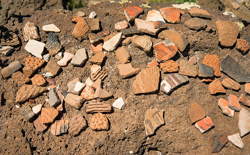
At the door Kiva’s door is a display of pottery sherds for you to examine. You’re welcome to pick them up and look closely, but please put them back so that others can have the same opportunity.
We started walking up where the bigger rocks were kicked aside until we got to flat rocks that were reinforced and cemented in place. Ah, a trail — I get it. We’d move forward until we got winded, and Phil would conveniently stop and find something to talk about long enough that we’d catch our breath. The walking stick helped me keep my balance with a camera on one shoulder and bag on the other. Before we knew it, we reached the Grand Kiva — a large meeting hall — with basalt stone walls four-foot tall and equally wide. We listened as Phil talked about two hundred men packed in the smoke-filled ceremonial room. Then we went up more steps till we got to the 150 room apartment house were we heard stories of the ancients and how the volunteers take care of it.
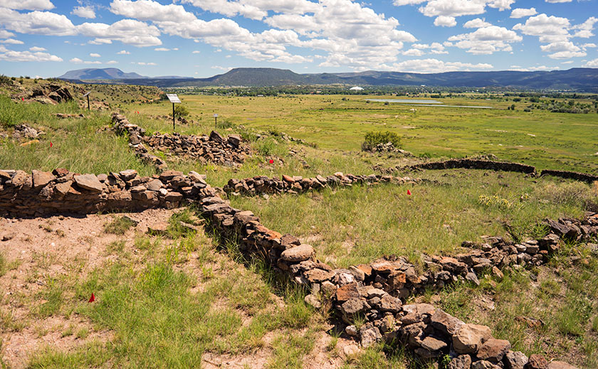
The pueblo at Casa Malpais has over one hundred fifty rooms, some of which have never been excavated. In the background is the town of Springerville at the foot of the White Mountains.
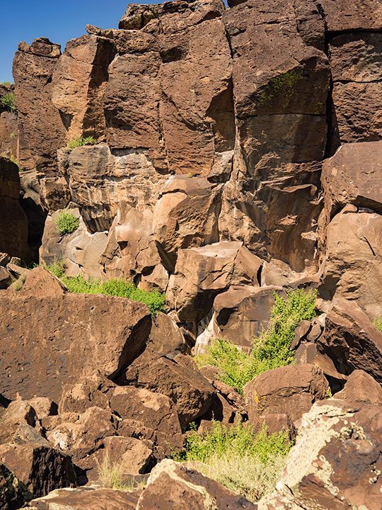
As we walked around the pueblo’s back side, Phil took us aside toward the cliff wall. “This is the lost canyon,” he said pointing at where the lead edge of basalt columns had pulled away from the original cliff. “Jeff and I have explored back there,” he said in such a way that you knew he had a genuine love of this place. Then he showed us three rams head petroglyphs carved into the rocks. “That one marks the summer solstice, the one on the right is the spring equinox and the one in the middle lines up with the cross quarter.” I would never had seen them, much less got a photograph if we were on our own.
Behind the Pueblo is a place where the leading edge of basalt columns have pulled away from the cliff. See if you can find the three rams head petroglyphs carved into the rocks.
We spent two hours on the ledge listening to Phil explain what he knew and us asking questions like a couple of six-year-old. He answered what he could and was honest about what his speculations were. “I wish I could go back 800 years to know that answer, but my best guess is … ” Before we knew it, we were back at the bus. Neither of us had fallen and I hadn’t dropped anything into a bottomless crevice, so I counted the day a success. When I mentioned this, Phil said, “Yeah, last month I went out with four and came back with two. My boss said, this is not good.” On the drive back he told us that story. If you’d like to hear it, sign up for a tour and ask Phil.