As you would expect, the edge of the Colorado Plateau isn’t smooth and polished. It’s quite the opposite. Over eons, the streams that drain the plateau have eaten away the walls and carved a series of steep canyons. These parallel canyons look like an evil witch with rheumatoid arthritis pressed her fingers into a curb of wet cement.
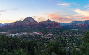
Oak Creek Canyon—and the village of Sedona—is probably the most famous example that I can name. The creek has cut into the iron-rich sandstone leaving behind beautiful red-rock formations that attract visitors from the four corners of the globe. And why not? There’s a lot to see and do here. Magazines have called Slide Rock one of the ten best swimming holes in the country (Havasupai Falls also made that list, not bad for a desert state, eh). Sedona always makes the top of the list for romantic getaways for Valentine’s Day, Thanksgiving, Christmas, and on and on and on. If you want to be romantic in Sedona these days, you have to be careful not to bump the couple making out next to you.
When people visit Oak Creek Canyon and Sedona, they understandably fall in love and don’t want to leave. Over the past 50 years, I’ve seen Sedona grow from a gas station intersection to a resort town that’s on a par with Aspen, Telluride, or Santa Fe. The catch is that there’s not enough water to support all of the rich people building second homes there. We all visit to see nature at its best, but now the McMansions are in the way. We love it to death.
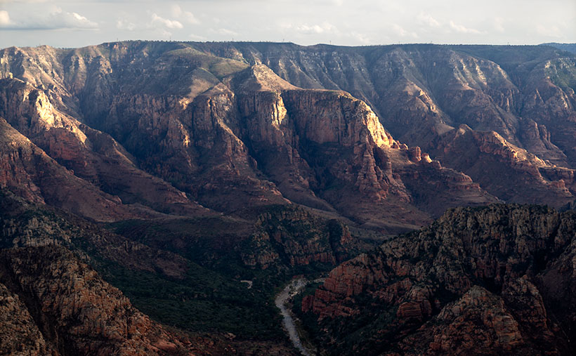
But there’s hope for us tree-huggers. Less than 17 miles northwest of downtown Sedona is Oak Creek Canyon’s sister—Sycamore Canyon. Here there are no McMansions, Gucci Stores, or Whole Foods because, in 1972, the Feds set it aside as a Wilderness Area. While standing on the rim at Sycamore Point, you can begin to imagine what Oak Creek Canyon was like before the mobs got there. Imagine a time when a campfire was the only tell of humans in the area.
My friend Deb and I camped here before Queen Anne ever arrived on the scene. When she finally did, this was the first place Deb and I took her camping. As we ate a dinner of grilled stuffed pork chops and watched the sun go down, she was hooked. That’s when we convinced her that everything tastes a little better with dirt on it.
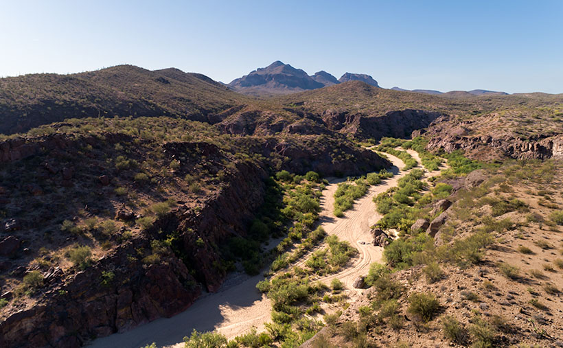
I wanted to come back this year after watching the fire news early this summer. One fire had ripped through here, and I wanted to see how much damage it caused. Queen Anne and I found black scars on the ridge on the canyon’s far side, but only a couple of pinions had burned on the edge where we stood. Overall, the canyon fared well, except years of drought have left Sycamore Creek dry. We didn’t see any remaining pools of water from our vantage point.
The BLM has moved camping back a half mile now. They’ve removed all of the rock fire rings and built a parking area. If you want to come here, your best camp is at one of the small lakes up the road. Since Sycamore Point is less than twenty miles from Williams, it’s an easy drive from town and back in one afternoon.
As the sun got low, it reached a crack in the clouds and lit the cliffs while I had my camera in hand. I snapped a couple of shots, and this is the version I preferred. I named the photo Sycamore Canyon. I like how the setting sun makes the cliff faces glow, but you can still see the dry creek bed below. Along the rim in the center-left, you can make out the black scar left by this summer’s fire. That’s ok though, unlike a McMansion, it’ll heal soon.
You can see a larger version of Sycamore Canyon on its Web Page by clicking here. Next week, we return to the bright lights of Williams. Come back then and see what we found.
Until next time — jw