Date Creek and Tres Alamos Picture of the Week

Working during the summer is challenging, whether in house chores or photography. That’s why my favorite pastime during these months is procrastination. Face it; I’m allergic to heat. Thinking about going outside is worse than actually doing so. After all, in today’s southwest, we’ve learned to minimize our heat exposure. We move about in a succession of air-conditioned cocoons.

Heat is why I had difficulty coming up with a theme for  July. The monsoons haven’t kicked in yet, so most pleasant campsites are on fire or closed. I must stay close to home, venturing early or after dinner, find a shot, and then hurry home.

I decided that July’s theme will be U.S. Highway 93. That’s the main thoroughfare near my house that Phoenicians (and Tucsonans) use to commute to Las Vegas. The route goes to Canada, but I’m only concerned about day trips. Because I’ve often traveled the section between here and Kingman, I know a few vistas I wanted to capture on film but never had time to stop. This week’s image is an example.

Date Creek and Tres Alamos - Date Creek as it flows by the Tres Alamos Wilderness Area near Congress, Arizona.
Date Creek and Tres Alamos – Date Creek flows by the Tres Alamos Wilderness Area near Congress, Arizona.

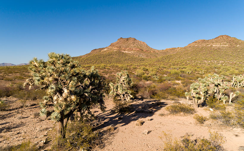
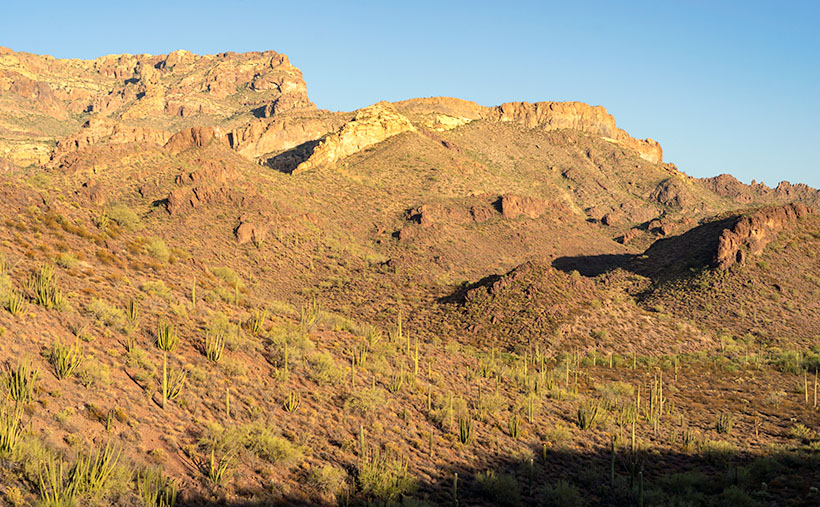
North of the SR 71 – 93 junction, the Alamo-Congress Rod is a lousy shortcut to Alamo Lake. It’s a broad dirt road that gets graded annually at best. It passes the Tres Alamos Wilderness Area about 10 miles west of the paved highway. It’s a small nature preserve (83,000 acres) compared to the neighboring Arrastra Mountain Wilderness (129,800 acres). The high point on which Tres Alamos is centered is the 4257-foot Sawyer Peak. To reach the spot where I took this shot, I had to slowly travel a couple of miles on a Jeep trail that left Archie with some Arizona Pinstripes—a badge of honor for a Luxo-SUV.

The wash in this shot is Date Creek, which should be familiar to regular readers because Congress—and the old Congress Gold Mine—are located next to the mountains of the same name. As it were, the creek flows from the Weavers, along the north side of the Date Creeks, to where it merges with the Santa Maria River upstream from Alamo Lake.

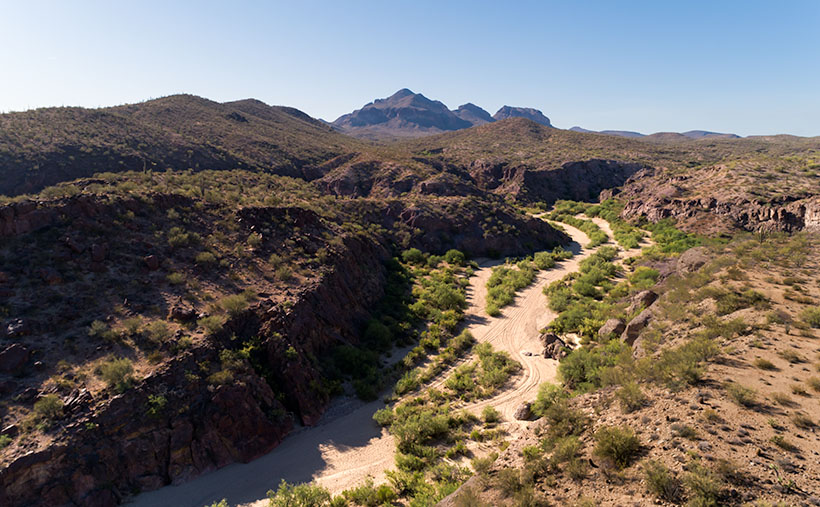
An interesting thing in the photo is the tire tracks in the sand. With the rising popularity of those all-terrain buggies, it’s easier for off-roaders to drive through the washes. Most of the time, the ride is smoother than the so-called mine roads. However, in the past, you could see tracks of the animals crossing the river bottoms. It was a visitor guest book. Now that natural history is erased each time they drive over it.

When I first moved to Congress, I coveted owning an ATV. I thought it would help me get into the backcountry and get some unique landscapes. After a couple of rides in Fred’s, I found them uncomfortable because you’re exposed to the elements, and riding in his air-conditioned FJ is more my style of roughing it. Earlier this year, I got hooked on watching Matt’s Off-Road Recovery. He’s a towing company in Hurricane, Utah, and he documents his crew on YouTube as they drag 4-wheelers back to civilization. The best part is that he uses a modified Corvair Lakewood—the station wagon version. Watching him drag ATVs off mountains and dunes convinced me I was better off without one.

Click here to see a larger version of Date Creek and Tres Alamos on its Web Page. Next week, we’ll travel further down the highway and see what’s around the next bend.

Until next time — jw

Joshua Tree Below Picture of the Week

Everyone has several traits that make up their personality, and psychologists measure these traits by where they fit on a line—called a continuum. The most common example is being an extrovert or an introvert. Most people fit in the middle, of course, but some people are really outgoing and unconstrained, while others are shy or withdrawn. I’ll bet, off the top of your head, you can name several people on either side of that teeter-totter.

Another—lesser-known—continuum is thrill-seekers. Even if you’re not adventurous, you’re still somewhere along that line—maybe just right of center. You can name friends that will jump out of a perfectly good airplane while others avoid sidewalk cracks. I’m a moderate risk taker, but there are certain things I won’t do. I’m not too fond of roller coasters, for example. More accurately, I don’t like the initial weightless drop—I’m fine with the sharp twists and turns throughout the ride’s latter part.

Another fun thing that I can’t make myself do is bungee jumping. I’m confident that the hosts know what they’re doing, and the physics have been worked out to the last decimal place. I also know that with my obesity, jumping off a bridge would lead to my premature demise. And I can tell you exactly how it happens.

I’d have to watch at least a half dozen people come back alive before I summoned up the courage to give it a try. Once I put on the helmet and harness, I’d be trapped. Somehow, I’d climb up on the railing and stand there for an eternity before closing my eyes and jumping. That’s just the beginning of the end. When that feeling of weightlessness first hit my stomach, I’d spew the old Technicolor yawn. As I fell through the air, I’d be surrounded by atomized droplets of my morning breakfast. Then at the bottom, I’d start the rebound only to find out that Galileo was wrong. I’d hurtle upstream through my own mouth shower. At the apex, I’d catch a whiff of my own stench and spew second upchuck, and I would fall through that mess a second time. But—at the bottom—the overstressed bungee cord catastrophically fail, and I’d do a belly flop on the ground. As I lie there, a gentle vomit mist would fall, covering my lifeless body. For a final insult—and as everyone who watches South Park knows—your bowels release the moment you die. No one would ever volunteer to come and clean up that mess. The authorities would throw a blue tarp over me, and that spot would become my forever resting place.

Joshua Tree Below - The sight of a pointy object, like this Joshua Tree, hurtling towards you should make you reconsider skydiving in the Sonoran Desert.
Joshua Tree Below – The sight of a pointy object, like this Joshua Tree, hurtling towards you should make you reconsider skydiving in the Sonoran Desert.

What motivated me to consider my tragic demise was this week’s featured image—Joshua Tree Below. All I intended to capture was a different view of one of our Joshua Trees—the large tree in the second image, to be exact. But, when I processed the photo, it became obvious why no one should skydive in the Sonoran Desert—no matter where they lie on the Thrill Seeker Continuum.

Black Mountain Joshua - The large Joshua Tree before Black Mountain is the model I used for this week's featured image.
Black Mountain Joshua – The large Joshua Tree before Black Mountain is the model I used for this week’s featured image.

You can see a larger version of Joshua Tree Below on its Web Page by clicking here. Be sure to come back next week when we begin a series of photos from Skull Valley.

Until next time — jw

Skull Rock Picture of the Week

It’s the beginning of May, and right on cue, we reached temperatures in the triple digits. The heat immediately sparked an exodus of winter visitors out of our park. Even some of our full-time residents have already left for summer retreats. Queen Anne and I have been abandoned by our friends to deal alone with the pair of terrorists nesting in the trellis outside our bedroom window.

Since we moved into our Congress home, we’ve had all kinds of birds nest in our vines outside. We’ve had quail, dove, hummingbirds, verdin, and the usual assortment of sparrows—the low-life of the bird world. They’ve always been quiet and discrete and never called attention to themselves. This pair is an alumnus of the Delta Tau Chi.

In spring, we love sleeping with open windows. The fragrant fresh breezes keep the house cool, and there’s the occasional coyote howl, hooting owl, or the sound of a nighthawk we enjoy. As the sun begins to show light in the eastern sky each morning—the mornings are getting pretty early these days—Frank and Margaret celebrate surviving another night by perching on the trellis top and begin a sparrow’s equivalent of “Ode to Joy.”

Have you ever really listened to a sparrow’s song? It’s a flat, monotonous “chirp – chirp – chirp.” If left unattended, it can go on for hours. The Queen—who has disdain for anyone having pleasure—soon yells, “Off with their heads.” My obedience is blind, so I stumble out of bed, walk over to the window, throw back the sash, and scare the birds away with my ugly pre-coffee face. That chases them off, but it’s only a while before they’re back and at it again. Sing – scare – repeat.

When the sun does come up, their second act begins. With the new light, they see their reflections in the glass, and like the emu commercial on TV, they start defending their nest. They fly against the window, pecking at the reflection. They fly back and forth along the window top, fighting their perceived intruder. It’s a wonder that my window isn’t perforated. It doesn’t stop until I get up, walk over, pull down the blind, and show my face.

It’s gone too far, so I concocted an evil plan to get even. I went to Goodwill today and purchased an old-timey alarm clock—a bright yellow one. You know—the kind with two bells on top that dances around the end table until you smash it with a hammer. I set the timer for 2 am and hid it in the vines near their nest. I can’t wait for tomorrow when Frank makes a sparrow’s impression of Don Knotts. Meanwhile, I found an old English recipe for Sparrow Soup if it doesn’t work.

Skull Rock - People in Yavapai County love to paint rocks resembling objects to make it more obvious to other people.
Skull Rock – People in Yavapai County love to paint rocks resembling objects to make them more evident to other people.

This week’s featured image is called Skull Rock. The people in Yavapai County have a thing about painting rocks that resemble things because people would never figure it out on their own. Unlike our frog, you have to search for the skull. It’s halfway up the Hillside dirt road. It’s hidden behind the elevated railroad tracks, so you have to do a bit of climbing to get a shot of it. One story I read said a Santa Fe engineer originally painted it to tell passengers that the Apaches killed a poacher and left his skull behind to warn others. Then he’d laugh when they reacted as the train rounded the bend and the rock came into view. I can’t vouch for the story’s validity, but it sounds reasonable. You can see a larger version on its Web Page by clicking here.

Until next time — jw

Saguaro Bouquet Picture of the Week

We’ve spent March exploring the Black Hills—an interesting group of low mountains on Wickenburg’s north side that gets their name from the dark surface crust on their top. I was able to shoot them from different perspectives by driving the old mine roads that my SUV—Archie—could navigate easily. While I’m out jaunting about and looking for different angles of my subject, I try to keep an eye out for other good scenes—and that’s the case with this week’s featured image.

When I drove out Rincon Road a couple of weeks ago, I intended to get the shot Black Hills—last week’s featured image. While I was there, I discovered a hill covered with saguaro. As I’ve written before, saguaro does well on a south-facing well-drained slope, and when I see a stand like this, it makes me happy. This is a healthy forest. Since I’d already invested the time driving out there, I also took this shot.

Saguaro Bouquet-A small but dense grove of saguaro growing on a hillside near Wickenburg, Arizona.
Saguaro Bouquet-A small but a dense grove of saguaro growing on a hillside near Wickenburg, Arizona.

I named this week’s image Saguaro Bouquet jokingly because—although they each weigh a couple of tons—it looks like you could pick them for a Mother’s Day bouquet (hey, no one said I was normal). Although this grove is small, it’s densely packed along the hillside.

There are some other things I see in the photo. It was still winter when I took it, but the scene will change dramatically as the weather warms next month. For example, the little gray bushes covering the ground are brittlebush. In a couple of weeks, they will sprout yellow daisy-like flowers. Shortly after that, the palo verde trees will start flowering, adding more yellow. Finally, in May, the saguaro will be adorned with large white blossoms. That’s an Arizona Highways kind of picture. If you’d like to see it yourself, ask me, and I’ll give you the map coordinates.

I am happy you took the time to view my new photo. You can see a larger version on its Web Page by clicking here. Be sure to come back next week for a complete change of pace. I promise that for April, there won’t be a single saguaro.

Until next time — jw

Ajo Mountain Foothills Picture of the Week

In my post a couple of weeks ago, I tossed out the fact that Organ Pipe Cactus National Monument was established in 1937—Franklin Roosevelt proclaimed it on April 13th, to be exact. In the subsequent weeks, we’ve explored the east side loop, which shows off the beautiful and rugged Sonoran Desert. So we accept that the monument is worth traveling a half-hour south of Ajo to visit—in fact, 22 million people did that last year—but in 1937, who knew?

If you look at a 1935 Arizona road map, you’ll notice that there isn’t anything south of Ajo except for the Papago Indian Reservation (They now call themselves Tohono O’odham, which means “Desert People” in their language—Papago is a derogatory derivative of a Spanish word for “Bean Eaters”). The only settlers in the Monument area were the Grays—a ranching family who bought up several local homesteads. So, how did word get back to the president about this unique area?

I came across one story that I liked, and I hope it’s true. In the Wikipedia listing for Organ Pipe Cactus National Monument, I found a line that says, “Land for the Monument was donated by the Arizona state legislature to the federal government during Prohibition knowing that the north-south road would be improved and make contraband alcohol easier to import from Mexico.” Of course, the very next words are “Citation needed.” It sounds too good to be true, but it also sounds like something the Arizona Legislature would do. A fact that makes me skeptical is that Prohibition was repealed in 1933, four years before Roosevelt’s proclamation. If the story is true, the smuggler’s highway has become the main thorofare to the Arizona Riviera—Puerto Peñasco—or as we Zonies call it, Rocky Point.

Ajo Foothills - Organ Pipe and Saguaro grow on a hillside below rugged cliffs in the Ajo Mountain Range.
Ajo Foothills – Organ Pipe and Saguaro grow on a hillside below rugged cliffs in the Ajo Mountain Range.

This week’s featured image was taken on the Ajo Mountain Loop’s downside as the road descends into a valley among the foothills. The shadows were getting long when I took the shot, and you can see Organ Pipe and Saguaro growing on the hillside below the rugged cliffs of Rhyolite and Tuff. I call this image Ajo Foothills.

I really enjoyed my afternoon at the monument. I want to return and drive the western loop. I want to take the Ritz and spend a night under the stars. Maybe we can do that next year when we’re able to move about the country again freely. Besides, there are other beautiful places in Arizona that we can show you in the coming months.

You can see a larger version of Ajo Foothills on its Web Page by clicking here. Come back next week when we begin another adventure traveling Arizona’s back roads.

Until next time — jw