In my effort to bring you photos from this month’s Aquarius Range Project, I returned to the crime scene last week and explored more of the Mohave County mountains. According to my trusty DeLorme Gazetteer, there are two roads—meeting my requirements—that cut through the Aquarius Mountains: the Trout Creek Road that I covered over the past couple of weeks and a second road called Burro Creek Crossing, which is nine miles south of Wikiup.
If you’ve ever driven to Vegas on US 93, you’re familiar with the twin bridges spanning a 400’ canyon at Burro Creek. It’s one of the few desert creeks that run all year. Its headwaters are at the foot of Mount Hope on the San Louis Baca Land Float No.5—the Spanish Land Grant I mentioned last week. From there, Burro Creek flows in a canyon between Goodwin Mesa and Bozarth Mesa, under the bridges, and eventually into the Big Sandy River and Lake Alamo. There are several places where the roads cross the creek; the campgrounds on Highway 93 and the Six-Mile crossing are two that I’ve made. Six-Mile is the ford you make on Burro Creek Crossing Road.
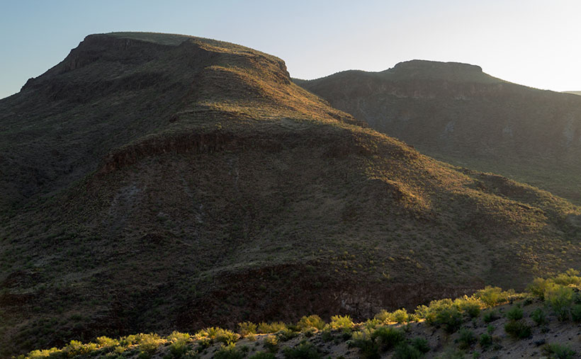
Immediately after turning off Highway 93, Burro Creek Crossing begins to climb into the Aquarius Mountains. The first few miles run along the south wall of Box Canyon and past a small mountain-like structure called Burro Cliffs—the subject of this week’s photo. When I got there, the sun had barely cleared the horizon and bathed the hills in a warm yellow color. The light’s low angle pulls out the luscious curves in the mountain while the vertical walls of basalt show as dark fortresses along its flank rising from Box Canyon. I liked the backlit trees along the ridgeline in the foreground, so I included them for detail, contrast, and scale. Palo Verde and Mesquite appear as bushes, reaching 10-20 feet—well over a person’s head.
After I took this shot, I continued along the road to Burro Creek crossing, and guess what? I found it there. Burros! I saw about a dozen of them along the way. That’s the only wildlife I saw on this trip (besides the dead snake in the road that a roadrunner killed). The wild burros have become a systemic problem in Arizona. Spanish prospectors first abandoned them in 1690, and each subsequent generation of prospectors contributed to the situation by releasing them after their claims ran dry.
Most people find them fuzzy and cute, but the mules don’t have a natural predator. They aggressively defend their young and will gang up to chase off a big cat. They can survive by eating anything and everything. Unlike deer, antelope, and bighorn that eat grass shoots, the donkeys pull the plant right out of the ground; roots and all—try that on your lawn. They kill trees by stripping off the bark and branches as food. According to BLM, Arizona has four times the amount of burros that the land can support. I think Shrek should have clubbed Donkey in the first reel and we would all live happily ever after.
You can see a larger version of Burro Cliffs on its Web Page by clicking here. Be sure to come back next week when we set off for another adventure exploring more Arizona back roads.
Until next time — jw