Schwertner House Picture of the Week

Schwertner House - Built as an overnight barracks for Army officers during the Apache Wars, the Schwertner family bought and lived in the house until 1980.
Schwertner House – Built as an overnight barracks for Army officers during the Apache Wars, the Schwertner family bought and lived in the house until 1980.

In 1880, when Southern Pacific established a whistle-stop in Willcox, there was peace everywhere in the country except in Cochise County. Here the Army was busy battling Cochise and Geronimo in the Chiricahuas. Stupid decisions made by Army officers prolonged the Apache Wars, but that’s another day’s story.

The U.S. Army operated from several forts in the southeast corner of the Arizona Territory, and the newly built railroad was an efficient way to get officers into Arizona. So, the Army immediately paid to have a boarding house built within walking distance of the Willcox train station. The green officers had a place to stay until troops escorted them to Fort Bowie, Fort Grant, or Fort Thomas.

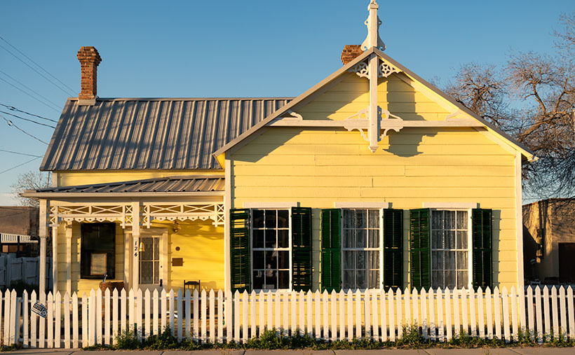
After hostilities ended, Joseph Schwertner bought the barracks for his family’s home. Joe was a well-off Schley saloon owner, one of several that lined Railroad Avenue at the turn of the century. After Joe died in 1929, his heirs continued to live in the house until 1980, when they gifted it to the local historical society. Today, the pretty little yellow house with green shutters is one of several buildings in Willcox on the National Registry list and is open for tours.

In this week’s picture, I shot the historic home at dawn just after I got my first cup of coffee and my eyes finally opened. I called the shot Schwertner House—its proper name. In addition to the lovely morning light on its yellow front and new metal roof, I like the picket fence (I’m a sucker for picket fences because they’re rare in Arizona). The dark green shutters should be next on the TLC list.

What if you’re not into history and old buildings? What else is in Willcox that makes it worth a visit? A mile or so east of the railroad crossing is the town’s golf course. It’s not fancy, and it will never be on the PGA tour, but that’s not important to most golfers. I’ve never been good at stick-and-ball sports, so I’m not keen on golf. However, on the road and just past the course is something that I do find exciting.

Willcox Playa Sandhills - Sandhill Cranes stop at the Wilcox Playa on their way to Canada.
Willcox Playa Sandhills – Sandhill Cranes, stop at the Wilcox Playa to rest and feed on their way to Canada.

We started our Willcox story a couple of weeks ago by explaining why Southern Pacific picked this spot for a stop. The railroad located the town along the northeast part of the Willcox Playa. Usually a dry lakebed, there is enough seasonal water to fill the low spots. Because these shallow pools are dependable year after year, migrating waterfowl stop for food and rest.

The most notable flock of birds is the Sandhill Cranes. The large stilt-legged gray birds are in the ponds late winter until the weather warms enough to continue to Canada. The playa is the best place to watch the red-faced birds this side of New Mexico’s Bosque del Apache preserve.

Since the access road encircles the ponds, you can watch the cranes from your car. In freezing mornings, the birds cluster in tight groups, communicating with trills, clucking, and squawks. Before they take to the air, their cacophony gets louder and the pace quicker. Then a half dozen take a couple of steps and flap their long broad wings rising gracefully above the pond. In winter, the air in Sulfur Springs Valley has temperature inversions, so the birds fly up to where the air is warmer and soar over town. The locals proudly call the phenomena Wings over Willcox, or WOW.

You can see a larger version of Schwertner House on its Web Page by clicking here. Next week, I have a final shot of historical Willcox, so come back and see what we’ve dug up.

Until next time — jw

Eagletail Peak  Picture of the Week

In last week’s article, I mentioned that the Eagletail Wilderness encompassed two desert mountain ranges and the Sonoran Desert basin that lies between them. The Eagletail Range was one, while the other is a chain known as Cemetery Ridge. After I gave you their name, I made an offhand remark about how they got that name. Well, I accepted that question as this week’s homework assignment, boys and girls. Here’s what I found—nothing.

Cemetery Ridge - A 16 mile-long chain of mountains that make up the southwest flank of the Eagletail Mountain Wilderness Area.
Cemetery Ridge – This is a 16 mile-long chain of mountains that make up the southwest flank of the Eagletail Mountain Wilderness Area.

Well, that’s not wholly true because, in my handy Arizona Place Names book, there is this entry:

“This sixteen-mile-long and two-mile-wide, low range was the scene of the killing of several prospectors in the 1870s, according to local stories. Their bodies are said to be buried on the ridge (sic), which is also known as Cemetery Hills.”

When I read that, I thought, “Alright, there’s an interesting historical story to tell my loyal readers.” So I, as the unofficial Marshall Trimble understudy, started a week of research that would have made Jimmy Olson proud. I wanted to find out what miners, who killed them, why, and where are they buried. I asked Alexa, Siri, Cortana, and Google’s unnamed assistant. None of them knew nothin’.

I did find out that I’m not the only person searching for those answers. Google referred me to the Desert Mountaineer blog. There I found the anonymous author had written a three-part journal covering Cemetery Ridge. The writer is a pretty good storyteller and photographer, but his passion is climbing mountains, and the photographs are incidental, kind of the opposite of what I do.

His three-part saga covers four days of driving the same roads I did, looking for graves. He travels with his dog, sleeps in his truck, and often stops to climb the mountains he passes—sometimes two or three in a day. I’m impressed! Anyway, after exploring the entire length of Cemetery Ridge, he didn’t find our legendary graves. He does mention the place where Deadman Wash crosses Cemetery Ridge on the west side. If ever there were a place to look, that would be where I’d start. It has all the intrigue of a pirate’s treasure map.

Framed between two of the Cemetery Ridge Mountains, Eagletail Peak's feathers lit by the sunrise.
Framed between two of the Cemetery Ridge Mountains, Eagletail Peak’s feathers lit by the sunrise.

I shot this week’s image along the Arlington-Clanton Well Road on the south side of Cemetery Ridge. The Ridge’s mountains (like hills really) appear and disappear in a straight line for 16 miles. At one of those places where they slip below the surface like a giant sea-serpent, I saw Eagletail Peak framed and lit by the sunrise. You can make out the ‘tail feathers’ sticking up at the top in the picture. I want to explain that the Eagletail Wilderness is directly under the Los Angeles-Phoenix flyway, so contrails are part of the natural landscape, but they won’t let me fly my drone there.

You can see a larger version of Eagletail Peak on its Web Page by clicking here. Next week we go hunting for more treasure in the Eagletail Range. Come back then and see if we were successful.

Until next time — jw

Skull Valley General Store Picture of the Week

Skull Valley (the town, not the people) is an odd community. You will think it’s another Arizona ghost town when you drive north on Yavapai County Road 10—Iron Springs Road. With its empty buildings, you’d be right to believe that. However, it wasn’t always that way. There’s a lot of history associated with this town.

Before the white man came here, it was home to the Yavapai Apaches, who were noted for marauding neighboring tribes. Undocumented stories tell of one particular raid they made on the Maricopas. In the skirmish, the Apaches stole crops, livestock, and women while killing the village men.

The Maricopa didn’t much like that, so the normally peaceful valley farmers gathered warriors to exact revenge. The gathering set off to hunt down the Apaches, and to keep this story short, they kicked ass and then left the raiders to lie where they fell. Years later, when Captain Hargraves was leading a squad of The First California Volunteers—the first white people that traveled through this area—they found a pile of bleached skulls in a dry wash. This was the only evidence of the great battle.

Then in 1866, a band of 100 Apaches challenged four freight wagons escorted by four foot-soldiers. One of the infantrymen ran three miles back to Camp McPherson for help (that’s what Skull Valley Station was long before it ever sold gas—see last week’s post). When the Calvary showed up, things quickly heated up, ending in a gun battle with another 35 Apache warriors added to the bone pile. At least, that’s what it says in my copy of Arizona Place Names.

Skull Valley General Store - After a century of serving the community and highway travelers, the General Store in Skull Valley closed in 2015.
Skull Valley General Store – After a century of serving the community and highway travelers, the General Store in Skull Valley closed in 2015.

The general store in this week’s featured image was opened in 1915 and served Skull Valley for over a hundred years. Half of that era was before freeways when the main highway between the Valley and Prescott was US 89 and/or the Iron Springs Road, and travelers needed to buy gas more frequently then. I suppose that—while you’re stopped—running across the street to buy a basket of food was handy. Locals both shopped and got their mail at the store.

Today, the passenger train doesn’t run anymore, and most of the Prescott traffic is on Interstate 17—on the other side of the Bradshaw Mountains. Little traffic flows through Skull Valley, and that’s probably the main reason two of the three buildings I’ve recently photographed have been shuttered. It would be easy for you to conclude that this little town is dead. You’d be wrong.

Oddly enough, our little town is Arizona’s mecca for Polo. The field is on the Van Dickson Ranch, and you’re welcome to come to watch a match—or worse, take lessons. On the dirt roads north of town, you can visit the Painted Lady Vineyard, smell the flowers at the Skull Valley Lavender Farm, and have a beer at the Barnstar Brewing Company. It’s a small craft brewery that’s open on the weekends. You would never know that these places were there because you can’t see them from the highway. I only found out about them from an Arizona Highways TV episode.

In this week’s picture, I really like how the morning light creates a two-tone effect on the building. I was there before 6 am so I timed the light pretty well. Incidentally, the cottonwood trees behind this building—and last week’s station—are growing in Skull Valley Wash—three miles upstream from where the bleached bones were discovered.

When I win the Power Ball, I’m going to buy this place and convert it into the perfect breakfast and lunch café/gallery—as I wrote about when we were still living in Goodyear. I will hire a Michelin Chef to run the place and have a Danish baker sell pastries in the front next to the cash register. All of the walls will be covered with my photographs for the patrons to enjoy and buy. Since there won’t be much traffic, I’ll purposefully run it at a loss until the money runs out or I do. Since I don’t care to work anymore, my responsibilities will be to stop in occasionally and sample the Danish Waffles for breakfast or the world’s best Reubens at lunch. Watch this space; I’ll let you know how it’s going.

You can see a larger version of Skull Valley General Store on its Web Page by clicking here. We have one more image to share from Skull Valley, so make sure to come back next week.

Until next time — jw

Skull Valley Station Picture of the Week

It’s been a while since I pointed my camera at an old building. The last time I did was before we all got locked up last year. I did publish that shot of Oatman’s empty streets last year, but that image spoke about desertion rather than historic buildings. I guess I missed this genre because after I shot the train depot in last week’s photo, I hung around and worked on other Skull Valley buildings.

Shooting architecture is a different discipline than nature photography. That’s because lens distortion is more obvious when you’re shooting boxes. That’s why view cameras have movements that allow the artist to correct for perspective distortions. These days, you can correct that in Photoshop—to a degree. A photographer can use a couple of other secrets to minimize camera distortion that I could reveal to you, but then I’d have to kill you.

As I grow old, history becomes increasingly important to me, so I wish I could tell you the story behind each of the buildings I shoot. However, most of my subjects are ordinary, and they’re only historic because they survived the wrecking ball. If I were a better researcher, I could visit the local museums and city halls to uncover records. Unfortunately, I’m not going to because I’m lazy. If it doesn’t exist on Google, then it never happened.

Skull Valley Station - Located on Iron Springs Road in Skull Valley on the north side of the Peavine tracks.
Skull Valley Station – Located on Iron Springs Road as it winds through Skull Valley just north of the Peavine railroad tracks.

Take this week’s featured image, for example. Up until this year, tenants used this building as a feed store. I guess that the pandemic was bad for their business, and they closed shop early this spring. I don’t know when someone last sold gas here, but the pump is set to 33 cents per gallon. I did find this article from The Daily Courier that suggests that a previous owner—Bob Colbert—didn’t know he owned a service station until he uncovered the original sign under layers of paint. Now someone has slapped more paint over the sign again (I wonder what happened to the other two pumps).

We drive by this building each month on our way to the Prescott Costco. It’s on the right immediately after Iron Springs Road crosses the Peavine tracks I talked about last week. I never stopped to take a picture because of the feed signs, and there were always newer vehicles parked outside. They kinda ruined the old-gas-state motif. This time with the early-morning light in the cottonwoods and dappled on the orange façade, I took time to shoot the station from several angles. This week’s featured image is the version I liked best. I called it Skull Valley Station. What else could I call it?

You can see a larger version of Skull Valley Station on its Web Page by clicking here. We’re going to hang around Skull valley for another couple of weeks, so come back and see what else caught my attention.

Until next time — jw

Skull Valley Depot Picture of the Week

I’m not considered a sociable person, so you may be surprised that I joined a car club back when I was a younger man—more than half my life ago (oh jeez, where has it all gone). This club’s existence was based on owning a particular brand—which one isn’t important for my story—but the club member’s general attitude was that no one should drive one of these cars because the mileage brought down their value. Insane, I know. Despite that, the club put on well-attended events like parties, tours, meetings, and track days.

The club event that drew the most participation was their annual progressive dinner. If you’ve never heard of that, it’s a three to seven-course dinner served at the volunteers’ houses who prepared each course. So we’d meet at the appetizer house, have a glass of wine, and when the food was all gone, we’d jump in our cars and drive to the next course. The club paid for the food and a couple of jugs of Carlo Rossi wines, and members paid a flat per-head attendance fee. The club made a lot of money. Things were different then. Phoenix had few roads north of Northern Avenue, and traffic was nil on Saturday nights, so by the end of the evening, the drive between houses turned into a Targa Florio race. Half the club would wind up in the slammer on DUI charges these days, and the insurance companies would cancel their policy.

Now hold that thought in the back of your head while I talk about the other part of another one of my grandiose ideas. I’ve written before about the trains that pass our house. They run less than a half-dozen times each day (and night), so the tracks are empty most of the time. The route runs from Phoenix to the northern town of Ash Fork, and it has so many twists and turns that it was dubbed The Peavine Line when it opened a century ago. The tracks run through the heart of Arizona’s historic gold mining country.

Historically our little train used to carry passengers with depots in Phoenix, Wickenburg, Congress, Kirkland, Skull Valley, Prescott (now bypassed), and Ash Fork. Most of the town’s stations are still there in one form or another. And—unlike the routes between Phoenix to Tucson and Phoenix to Yuma—there is some interesting backcountry scenery and at least two climate zones along the journey.

Skull Valley Depot - The townspeople of Skull Valley have put their abandoned depot to good use as a local museum.
Skull Valley Depot – The townspeople of Skull Valley have put their abandoned depot to good use as a local museum.

So, after my photo outing where I shot this week’s featured image in Skull Valley, I began to fantasize about having a progressive dinner—on a train. The trip would start in Wickenburg (or maybe Sun City West), then make scheduled stops where the old stations are. At each stop, you could peruse the local museum, enjoy the designated course, spend money on useless trinkets in the gift shop, pee, and get back on the train. Between stations, the guests could taste wine samples (from Arizona vineyards?) and purchase bottles that they would pick up at the evening’s end. At the end of the line, the train would make a leisurely two-hour trip back to the station. The night will have fallen by that time, and guests would enjoy non-alcoholic beverages to sober them up.

I only know of two train excursions in Arizona; the Verde River Line and the trip from Williams to the Grand Canyon. There once was the White Mountain steam train, but that closed a long time ago, and Durango bought the engine (which fell off the trailer along US 89—however that’s another story). I think there’s plenty of market for another train ride in our state, and the dinner would make it a unique experience. Think of it as a dinner cruise on rails.

If this lame-brain idea sounds good to you, then it’s yours. On the other hand, if you feel it’s a stupid idea, I never said anything. My brain hurts too much to work on stuff right now. I’m too old and penniless. Besides, it’s time for my nap.

You can see a larger version of Skull Valley Depot—the picture that set my brain on fire this week—on its Web Page by clicking here. Be sure to come back next week when we continue with another Skull Valley artifact.

Until next time — jw

Verde Limestone Picture of the Week

For centuries the Verde River Valley has been a peaceful home for many peoples. It makes sense because the Verde River flows year-round, even in times of drought—as we have now. The green waters of the Verde—Spanish for green—flow between the Black Hills (Mingus Mountain) on its south-west flank and the Mogollon Rim to the north-east. The river runs from Chino Valley to Fountain Hills—170 miles. It collects the runoff water from the rim via its tributaries like Sycamore Creek, Oak Creek, Beaver Creek, and West Clear Creek. Although the river bottom is a dense cottonwood forest, its flood plains are perfect for growing corn and squash.

There are many sites of early inhabitants along its length, but the best known is the pueblo of Tuzigoot—built by the Sinagua people in the 10th century. They only lived there for a couple of centuries before moving on. The next settlers to arrive were Apaches—Canadian migrants that were chased off the plains by the Sioux. The various bands of Apache established homes along the transition zones across Arizona and New Mexico. They weren’t aware that their new landlords were the Spanish, who were mostly interested in saving their souls and stealing their gold. For the next 300 years, life in the Verde River Valley was peaceful.

Then one day, in 1821, there was a knock on the door—er, teepee flap. It was a government man. He was there to inform one and all that they were Mexican citizens now and, by the way, do you have money to chip in for our new country?

After that, things began to happen fast, and life seemed to go downhill quickly. A mere 30 years went by when another man rode up on a horse, shook a bunch of hands, handed out flyers, and declared, “Welcome to America.” The very next year, Californians discovered gold, and easterners clogged up the trails rushing to get to it. Some got rich, but most of them didn’t get to the Golden State in time, so they made their way back and decided that our valley would be an excellent spot for a farm. There was a civil war going on back home anyway, so they moved into the neighborhood. The Apache’s homeland began to shrink.

In 1864, the Americans stuck a flag in the ground and called it Fort Whipple—the Arizona Territorial capital. The next year they moved the flag from Chino Valley to a mining camp on Granite Creek. The Army stationed cavalry troops to protect the miners, and that later became the town of Prescott.

Life was tense, but there was an uneasy truce between the tribes and the new settlers until those mangy miners started working the Verde Valley. They picked at the rocks, piled dirt everywhere, muddied the water, ate all the food, and drank all the whiskey. It was the straw that broke the Gila monster’s back, and the Apache tribes declared war—Yavapai War (1871-1875). That’s the precursor of General George Crook’s assignment to Fort Whipple and his trail to Fort Apache that we began exploring last week.

Verde Limestone - A limestone ledge in the Verde River Valley in the lovely light of the evening sun.
Verde Limestone – A limestone ledge in the Verde River Valley shines in the lovely light of the evening sun.

This week, we traveled east along the Verde River for a few miles and stopped near Dry Beaver Creek to photograph a limestone formation. They’re found throughout the valley and are most evident on the river’s north side. As you travel Interstate 17 towards Flagstaff, it’s the white layer between the Verde River and Sedona. Limestone forms in shallow seas from dead shells and bones. It’s a great place to look for fossils, and coincidently one of our planned stops was to be Fossil Creek, but it was closed due to COVID 19.

This week’s featured image—called Verde Limestone—shows a ledge exposed by years of erosion. For balance, I included the lower mound of the same compound shining in the lovely evening sunlight.

You can see a larger version of Verde Limestone on its Web Page by clicking here. Be sure to come back next week as we climb out of the Verde Valley and see what we found along the General Crook Trail.

Until next time — jw

Stamp Mill Picture of the Week

Everyone has heard the axiom, “All roads lead to Rome.” Well, not in Yavapai County, they don’t. Over the past couple of years of traveling Arizona’s back roads, I’ve found that they lead to mines, and with good reason. We all have a vision of a dusty prospector sneaking off with a couple of burros to a secret gold mine in the mountains—this is before he became the Arizona Lottery huckster. A man like Jacob Waltz may discover a vein of gold, but it takes a corporation to extract it effectively.

To make a ton of money, you have to move a thousand tons of ore. A couple of burlap sacks strapped to a burro’s back just won’t do. You have to move unrefined earth by wagon, truck, or railroad car. So part of The Company’s infrastructure is getting things to and from the mine site. That is the Phelps-Dodge and the Senator Mine story—and this month’s back road adventure.

While bouncing along the Senator Highway in R-Chee (according to his license plate that’s the correct spelling), Anne suddenly blurted, “There’s a large building down there.” Since my side wasn’t overlooking the cliff, I couldn’t see it, so I stopped the truck and walked back to see the steel skeleton of an old structure. “Cool,” I told her as I climbed back into the driver’s seat. “It’s too early, so we’ll stop on the way back when the light is better.”

Stamp Mill - The ruins of the Senator mine stamp mill are perched above the headwaters of the Hassayampa River.
Stamp Mill – The ruins of the Senator mine stamp mill perches above the headwaters of the Hassayampa River. The mill is visible on Google Earth if you zoom in to the Senator Highway where it crosses the Hassayampa River.

After some research, I found out that the building was a 10-unit stamp mill for the Senator mines. As rock came from one of the three parallel shafts, the miners hauled it to the mill, where the hammers pounded big boulders into small ones. As far as ghost towns go, we struck gold (I couldn’t resist the pun, sorry). Concrete foundations usually are all we find in these places, but since this frame was a steel and not timber, the skeleton survives and gives scale to its size. From the road, I could easily walk down the stairs and wander the four floors. Vandals have decorated the remaining vertical walls for Christmas with colorful graffiti everywhere, so I guessed that we weren’t the first people to find this place.

Kennecott Mine - The Kennecott mining town is preserved in the Wrangell-St Elias National Park in Alaska. This should give you an idea of how a mill looked with the clapboard still intact.
Kennecott Mine – The National Park Service has preserved the Kennecott mining in the Wrangell-St Elias National Park in Alaska. This photo should give you an idea of how a mill looked with the clapboard still intact.

In Alaska, I visited a similar mill at the Kennecott Mine in the Wrangell Saint Elias National Park. At this location, the Park Service keeps that building in an arrested state of decay, and it still has the red clapboard siding. I wanted to show you how the Senator stamp mill might have looked while it was running, so I’m including my Alaska photo.

For this week’s featured image—that I call Stamp Mill—I wanted to show the building and its environment, which is hard to do while standing inside of it. So, I took this shot from the far side of the Hassayampa River Canyon as the sun hung low in the western sky. I was lucky in that the remaining silver paint glowed in the afternoon sun, which makes the frame pop from the background.

You can see a larger version of Stamp Mill on its Web Page by clicking here. I hope you like it. Be sure to come back next week when we present the final image from our drive on the Senator Highway.

Until next time — jw