We put another 250 miles on today, and we arrived at Provo, an hour and a half south of Salt Lake City. Today’s route is one of my all time favorite drives. Head north out of Kanab following US Route 89. It provides access to Zion and Bryce Canyons, and a handful of State Parks too. Traffic was light, so we had time to look at the scenery. Unfortunately, not enough time to get any shots (Besides, the light is never perfect during the day).
When asked tonight, someone said that lunch was the highlight of the day. It was pretty good. We stopped again at Big Daddy’s Deli on a side street in Richfield. Anne, Sally and I ate there on a trip to Yellowstone a few years ago. Food is still good, and I’d recommend it for lunch if you’re in the area.
Tomorrow, we will be in Idaho. However, we will be traveling on I15 and through Salt Lake City. I don’t consider it a day of oo’s and ah’s. I must admit that the Wasatch Range is a pretty backdrop for the town.
It took longer than planned, but we made it to Kanab Utah, our toughest leg of our trip. I think we misjudged the time it would take to go through Prescott. A lot of traffic and a lot of twisty roads. We left Congress a little after seven in the morning and arrived at our camping site just before 5 PM. Since Kanab is on daylight savings time, we lost an hour and the trip took ten hours averaging 45 miles an hour. That’s including potty breaks, emergency stops, and lunch.
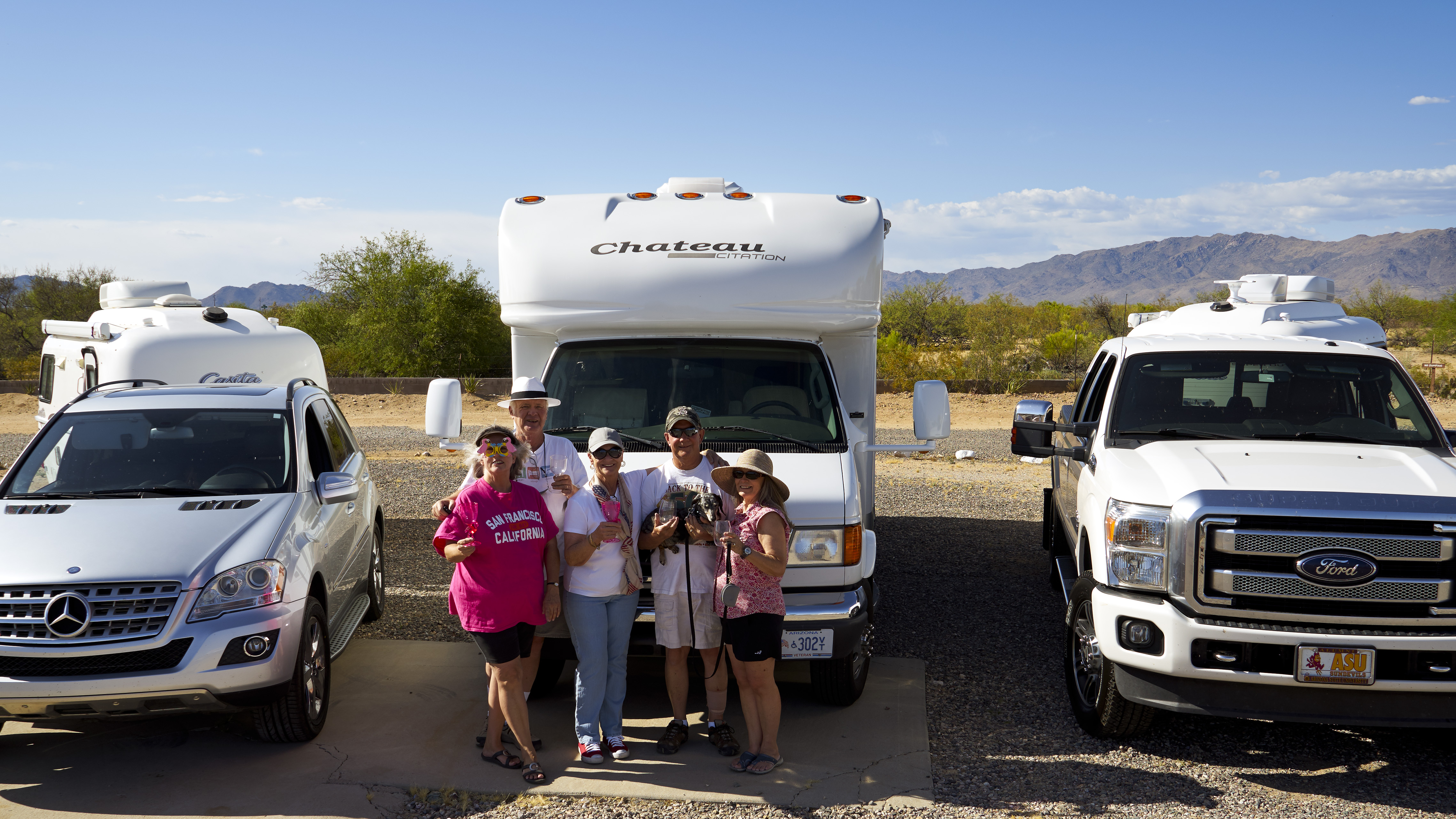
Deb, Sally and Anne stretch their legs in the shade of Sally’s RV.
We only made it to the top of Yarnell hill when Sally called on the walkie-talkie that one of her tire pressures was over 100 pounds. We pulled to the side of the road and sure enough, it was. After letting enough air out to match the others, we were back on the road.
Mickie D’s hosted lunch in Flagstaff. After taking four hours to get there, we were ready for the break. After that we made really good time as the roads and weather were good.
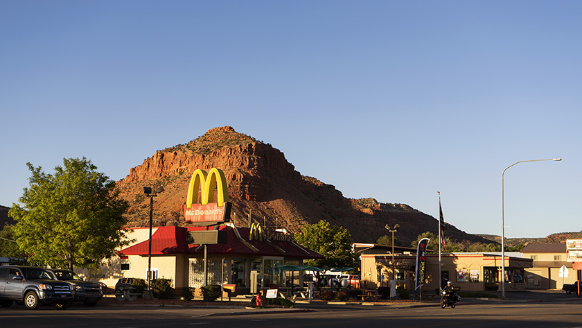
Located on the southern border of Utah, Kanab hosts tourists visiting the Grand Canyon, Bryce, and Zion National Parks.
Kanab is a little tourist town in southern Utah. It’s only six miles across the border from Arizona situated between the Grand Canyon, Bryce and Zion. It’s loaded with tourists and has a couple of nice restaurants. It’s most striking feature is that it is nestled under the Vermilion Cliffs and the brilliant colors they have at the end of the day.
Tomorrow we strike out for Provo. It will be a better day as the distance isn’t as great and there aren’t as many long pulls we have to climb. And to think, we only have 89 more days like this.
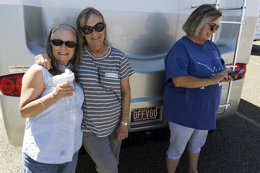
The gang takes a pack break to pose in front of the caravan. From left to right: Anne, Jim, Sally, Fred holding Gus and Deb.
Hold on to your hats, folks, because after a year of planning and packing, our road trip to Alaska and back to Arizona is finally kicking off tomorrow morning. We’ll be hitting the road from Congress, driving through Prescott, Verde Valley, and Flagstaff, and then spending the night in Kanab, Utah. I don’t know about you, but I won’t feel like I’m out of town until we’re on the other side of the San Francisco Peaks.
We’ve spent the last month getting our vehicles ready, but there’s always something else to pack. This morning, we had to make an emergency run to get longer chains because, of course, the hitch needed replacing. The pile of stuff in the dining room is smaller now, but I can’t shake this feeling that we’ve forgotten something… something important. But hey, at some point, you just have to get in the car and go. We’ll figure out what we forgot when it’s too late to turn back.
Our route will generally follow the I-15 corridor until we get to Montana, then we’ll cross the Continental Divide and head into Canada on the east side of the Rockies. From there, we’ll drive through the Canadian Rockies up to the Yukon Territory, and eventually reach Fairbanks.
We’ll make a loop through Alaska, hitting up Fairbanks, Denali, Anchorage, and the Kenai Peninsula before making our way back to Tok. And then, we’ll finally start the journey home. We plan to take a more scenic route on the way back, traveling along or near the coast until mid-California. But let’s not get too ahead of ourselves – who knows what kind of trouble we’ll run into along the way.
I’ll be posting updates from our journey, but it would take something pretty catastrophic to stop me from doing so (knock on wood). But hey, if something does happen, at least it’ll make for a good story, right? See you on the road!
Ah, the joys of extended travel. The open road, the breathtaking scenery… and the looming threat of losing all your precious digital files. I mean, what could go wrong when you keep all your images on those tiny little memory cards? I’ve had a few trips where a card disappeared into the abyss of the night, and my friend Jeff once left a box of prints in a motel room and had to backtrack to retrieve them. Can you imagine traveling nine thousand miles and having nothing to show? The horror.
So, how do I plan on safeguarding my files this time around? Rule number one is to back up your data and store it in multiple locations. I won’t be taking my work computer with me, but we splurged on a laptop perfect for traveling. It has loads of storage and plenty of working memory, and it can quickly run PhotoShop and my web management software. My first line of defense will be keeping backup files on it.
But what if the laptop gets damaged or lost? That’s where cloud storage comes in. There are many options, like Amazon Web Services and Microsoft Azure, but I decided to go with Google Drive. I already have a Google account, and their pricing plan was affordable.
Of course, you can’t rely on just one copy, so I shelled out $10 monthly for a terabyte of space. That should cover me for the three months we’ll be on the road. And if I need more space, I can grab it on the fly – no waiting required.
The beauty of cloud storage is that I can access it anywhere worldwide and upload my photos as I go. When I return to my desk, everything will be there waiting for me to download. Unless, of course, someone hacks into Google and destroys everything. Who needs digital memories when you have the real thing, right? (Please don’t hack Google, hackers. Pretty please.)
This morning, as is my usual routine, I visited the blog The Online Photographer, where I read the sad news the Michael Reichmann passed away May 18th at the age of 71. Michael was a man of many accomplishments, most significant to me; he was the creator of the Luminous Landscapes Website of which I was a regular visitor for the last thirteen years.
During my transition from film to digital photography, the Luminous Landscapes (also nicknamed LuLA) was my textbook for growing my art. Most important to me were the lessons on color management and printing techniques. I’ve integrated these ideas into my workflow and use them to this day.
My heart goes out to the Reichmann family and to his many fans that share with me this great loss.