Dean Peak Picture of the Week

Dean Peak
Dean Peak – One of several points in the Hualapais over 7,000′. I captured this as the sun was setting and the rest of the mountain was in shade.

There’s a Prime Video series Queen Anne, and I watched this month called Good Omens. We enjoyed it so much that we watched it a second time, and caught a lot of the subtler jokes that we missed the first time. The main characters—an angel and his demon buddy—aren’t very good at their jobs, and consequently, they screw up Armageddon. This riddle was in an episode, “How many angels can dance on the head of a pin?” It’s a trick question because as God—the voice of Frances McDormand—explains; Angels don’t dance, that’s something the devil conjured, and there’s not a substantial enough number to count them all, because demons can line-dance in the spaces between the pin’s atoms—funny stuff. When I visited this month’s photo location, I thought about the show’s riddle.

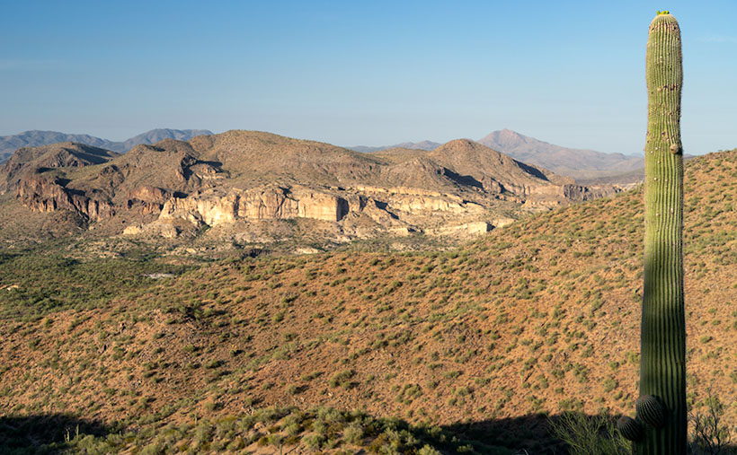
For my August pictures, I only had to walk across the street—as such. My new subject is the mountain range on the west side of the Big Sandy River and U.S. Highway 93—the Hualapai Range. They’re part of the parallel mountain ranges making the Basin and Range Domain which runs from Utah to the California Sierras. From space, these formations look like a pack of caterpillars stampeding across a sidewalk.

The Hualapai’s are a twin to last month’s Aquarius Mountains, except they are high enough—7,000 to 8,400—for pinion and ponderosa pine to grow. That means they are often snow-covered in winter. They fill the area between Wikiup and Kingman.

When my folks lived in Kingman, I heard of a park up on the mountain, but never visited, so last week I loaded Archie and drove up Sawmill Canyon Road (alas, if there was a sawmill, it’s gone now). The DW Ranch Road exit on Interstate 40 is a handy shortcut to use if you’re coming from the valley. It’s less than 10 miles from the Interstate to the County Park which is situated in a tiny valley at the top, and where Kingman residents have packed summer cabins into every available space. As I drove along the deeply rutted streets, I wondered, “How many Ford executives can camp on the top of Hualapai Peak?” In the village’s center, there is a concrete catch basin that’s called Pine Lake, but I couldn’t find public access to it, and—from its color—I’m not sure you would want access anyway. I got frustrated at having to back out of each street I tried and decided to check out the Hualapai Mountain Park and campgrounds.

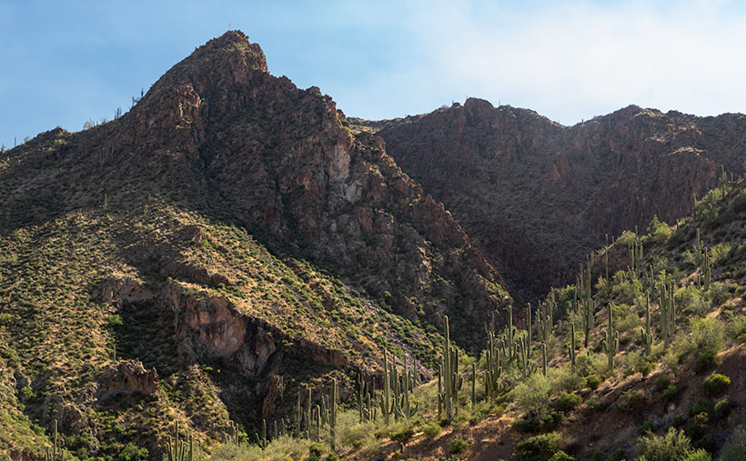
After paying a day fee, I parked in the trailhead parking lot and checked out the maps. It was already after five when I started on the path to Stair Step Overlook, about a half-mile hike. I was never athletic, and I don’t claim to be in great shape today. I grew up uncoordinated, and when I was a kid, I was always the last pick for team sports. But, I regularly walk now, and my average speed is over two miles an hour. I figured a 15-minute walk at the most, so I grabbed my camera and left my water in the truck. I was wrong. It took 10 minutes—coming back down the mountain. The trail climbed four-hundred feet in that half-mile. As I hiked, I followed a group of two men and a woman who were in their early thirties and equipped with day-packs. I followed them inch-worm style; they walked out of my sight and then they’d be resting when I caught up.

When I finally got to the overlook, my new hiking friends were lounging on large granite slabs and taking in the view. As I climbed up the stairs, I looked up to see six of them before my eyes could focus again. The woman looked concerned and asked, “Do you need water?”

“No,” I replied. “I only wanted to get here and take some pictures. I’m going back down right after that.”

Then the guy with the beard drove a stake through my heart, “Man! I hope that I can be hiking up and down some mountainside when I get as old as you are.”

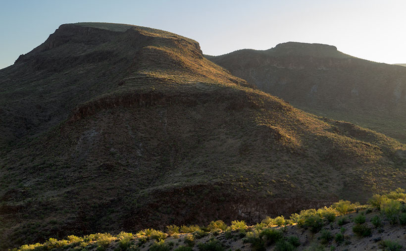
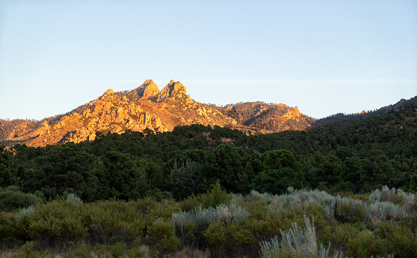
I did get a shot from the overlook, but I took this week’s featured image on the drive home. I call it Dean Peak because that’s what this point’s name is. When I took this shot, the sun was almost down, and the lower part of the mountain was already in the shade. I hope you enjoy viewing it.

You can see a larger version of Dean Peak on its Web Page by clicking here. Be sure to come back next week when we’ll be showing more from the Hualapai Mountains.

Until next time — jw

Clay Hills Picture of the Week

July is soon ending, and I’ll be writing about a different mountain range and its backroads next month. In a way, I’m not ready to move on. The Aquarius Range has more that I’d like to explore, and it may be a while before I get a chance to come back. I could use an extra Sunday to squeeze in another story. Oh well—a promise is a promise.

So, this week, we’ll finish up at the beginning or end—depending on your direction of travel—of the Aquarius Range, its south end. Here, there’s no sharp boundary that identifies that we’ve arrived. The mountains just taper into low hills then gently deliver you into the Burro Creek Valley at Six-Mile Crossing.

Depending on the source the Clay Hills or Hell's Half Acre
Depending on your reference these are the Clay Hills or Hell’s Half Acre as viewed from the south end of the Aquarius Range near Burro Creek Crossing.

As you descend from the higher mountains into the valley, you’ll notice a cluster of small hills with buckskin-colored cliffs for which I found two names. On the valley floor, there are Bureau of Land Management (BLM) signs saying these Clay Hills were restoration protection. On my TOPO Maps, however, they’re called Hell’s Half Acre. It amuses me that when pioneers found land that wasn’t flat and plowable, they called it Hell’s This or Devil’s That. I once had a friend who was an Ohio farm boy who told me, “… the Grand Canyon is a wasteland. You can’t grow crops there.”

I took this week’s image after I poked around the Six-Mile crossing for a while. I looked for a pretty shot of the creek running under the Cottonwood trees. The water was slow, stagnant, and choked with algae. It resembled a cesspool, so I gave it a pass, although the shade was pleasant.

As I began driving up into the mountains, I stopped to capture the scene that I call Clay Hills. It was already late morning, and the pretty light was quickly disappearing. The glare of the harsh desert sun would soon replace the warm colors. The camera is pointed west in this perspective and highway US 93 crosses Burro Creek Canyon on the far side of the cliffs. The pointy mountain eight miles in the distance is Burro Peak, so the air was pretty clear considering the recent fires near Prescott. For a cherry topping, I threw in a young saguaro with fresh buds sprouting from its top like the hairdo kids wear these days.

Click here to see a larger version of Clay Hills on its Web Page. Be sure to come back next week when we set off for another adventure exploring more Arizona back roads.

Until next time — jw

Burro Cliffs Picture of the Week

In my effort to bring you photos from this month’s Aquarius Range Project, I returned to the crime scene last week and explored more of the Mohave County mountains. According to my trusty DeLorme Gazetteer, there are two roads—meeting my requirements—that cut through the Aquarius Mountains: the Trout Creek Road that I covered over the past couple of weeks and a second road called Burro Creek Crossing, which is nine miles south of Wikiup.

If you’ve ever driven to Vegas on US 93, you’re familiar with the twin bridges spanning a 400’ canyon at Burro Creek. It’s one of the few desert creeks that run all year. Its headwaters are at the foot of Mount Hope on the San Louis Baca Land Float No.5—the Spanish Land Grant I mentioned last week. From there, Burro Creek flows in a canyon between Goodwin Mesa and Bozarth Mesa, under the bridges, and eventually into the Big Sandy River and Lake Alamo. There are several places where the roads cross the creek; the campgrounds on Highway 93 and the Six-Mile crossing are two that I’ve made. Six-Mile is the ford you make on Burro Creek Crossing Road.

Burro Cliffs at dawn.
Burro Cliffs – Not far from Highway 93, Burro Cliffs rises from Box Canyon as you drive up Burro Creek Crossing Road.

Immediately after turning off Highway 93, Burro Creek Crossing begins to climb into the Aquarius Mountains. The first few miles run along the south wall of Box Canyon and past a small mountain-like structure called Burro Cliffs—the subject of this week’s photo. When I got there, the sun had barely cleared the horizon and bathed the hills in a warm yellow color. The light’s low angle pulls out the luscious curves in the mountain while the vertical walls of basalt show as dark fortresses along its flank rising from Box Canyon. I liked the backlit trees along the ridgeline in the foreground, so I included them for detail, contrast, and scale. Palo Verde and Mesquite appear as bushes, reaching 10-20 feet—well over a person’s head.

After I took this shot, I continued along the road to Burro Creek crossing, and guess what? I found it there. Burros! I saw about a dozen of them along the way. That’s the only wildlife I saw on this trip (besides the dead snake in the road that a roadrunner killed). The wild burros have become a systemic problem in Arizona. Spanish prospectors first abandoned them in 1690, and each subsequent generation of prospectors contributed to the situation by releasing them after their claims ran dry.

Most people find them fuzzy and cute, but the mules don’t have a natural predator. They aggressively defend their young and will gang up to chase off a big cat. They can survive by eating anything and everything. Unlike deer, antelope, and bighorn that eat grass shoots, the donkeys pull the plant right out of the ground; roots and all—try that on your lawn. They kill trees by stripping off the bark and branches as food. According to BLM, Arizona has four times the amount of burros that the land can support. I think Shrek should have clubbed Donkey in the first reel and we would all live happily ever after.

You can see a larger version of Burro Cliffs on its Web Page by clicking here. Be sure to come back next week when we set off for another adventure exploring more Arizona back roads.

Until next time — jw

Mohan Range Picture of the Week

Have you ever looked at an Arizona road map and noticed the large chunks of unpopulated areas? It seems like the western third of the state is deserted. Most of the time there’s a good reason no one lives there and maps that show the land ownership quickly show why. For example, the military uses much of the land between Interstate 8 and the Mexican Border for bombing practice—what better use of a desert is there? Most of the area north of Interstate 40 and Utah is either the Grand Canyon or tribal land. The western third of Arizona is lower Sonoran or Mohave desert, and it gets a lot less rain than the rest of the state.

Then there’s Arizona’s Bermuda Triangle. Three highways define its legs: U.S. 93 on the west, Interstate 40 on the north and its eastern boundary is Arizona 89. The land included here isn’t desert wasteland; it ranges in elevation from 3-6 thousand feet. It’s transitional grassland, about the same as Prescott Valley. As I look out my window, I see thunderheads developing in that direction—as they do on most monsoon afternoons, so it gets seasonal rain. Why are there no settlements up there?

As I wrote in last week’s post, this month’s area of exploration is the Aquarius Mountains, and my first journey into them was via Upper Trout Creek Road. It’s a short loop road that intersects with Bogles Ranch Road which my map incorrectly identifies. It climbs to a pass and down the far side. At the top, there’s a religious retreat with a parking area wide enough to stop, take in the view, and then turn around, just like I did when I took this week’s featured image called Mohan Range.

Mohan Range-Very few know or have visited the Mohan Mountains in Arizona.
Named for one of General Cook’s Indian scouts, the Mohan Range is seldom visited.

I had never seen or heard about the Mohan Mountains before because as you travel US 93, the Aquarius Range hides them. At one foot shy of 7500’, Mohan Peak is substantial—one of the top 100. I’ve learned since that you can see it in the distance on Interstate 40 and from higher Prescott elevations. As is my way of doing things, I wanted to learn more about these mountains, so when I got back to my office, I hit Google pretty hard. This time I found a goldmine.

The first referral that came back was on a Peakbaggers page. These are people who—for no good reason—like to climb the top 100 mountains in each state (I have no idea what the do in Florida). It’s very informative, well written, and has photos of their expedition. It had a link to a second Webpage written by Kathy McCraine, which has even better photography along with her story of the O-RO ranch.

So why aren’t there any settlements here? Because this land—all quarter million acres of it—is the O-RO ranch (no Dr. Carson, it’s not a cookie). The ranch’s east half started with the Baca Land Float #5. That’s right, one of the authentic Spanish land grants honored by the US Government. According to her story, the original owners merged with a second parcel on its west side­—The Mohan Ranch—to create the most significant and oldest cattle ranch in Arizona. It’s run the same as it always was, cowboys on horses rounding up cattle and sleeping in tee-pees. With no town’s or roads, it a hard life and as Kathy tells it (I love this line), “Cowboy wannabe’s need not apply.” The ranch does not welcome visitors and if you’re the area, you best heed of the warning signs.   

You can see a larger version of Mohan Range on its Web Page by clicking here. Be sure to come back next week when we set off for another adventure exploring Arizona’s back roads.

Until next time — jw

Aquarius Boulders Picture of the Week

Long before Arizona was a state, it belonged to another country—Mexico. In retaliation to the Alamo massacre, the U.S. declared war on our southern neighbor and took away half of their land. When Mexico surrendered, we tossed fifteen million dollars (the same amount as the Louisiana Purchase) on the bed and said, “The money’s for the room, babe.” Our newest land acquisition was called New Mexico Territory, but—because it was so vast—we split it into several states. Arizona was the last to make the team.

To see what their money got, cigar-chomping Washington politicians handed some change to a young lieutenant—Amiel Weeks Whipple—then told him, “Here, kid. Grab a couple of guys, a tape measure, and measure the backyard.” This expedition was Lt. Whipple’s first across our state. He started in San Diego and headed east, surveying land along the new border. His second journey was in the other direction, and this time, he was to lay out a railroad route along the 35th Parallel—Interstate 40.

I mention Lt. Whipple because, when I research how an Arizona location got its name, it is often cited in Arizona Place Names—that’s the reference I usually use. As he worked his way across the territory, surveying, mapping, and fighting Apaches, Whipple didn’t have the luxury of stopping someone to ask, “Excuse me, but what do you call those mountains?” Not many people lived here, and many who did were cranky. After all, air conditioning hadn’t been invented yet. Instead, if a place needed a name, he’d make something up that seemed to fit.

That’s precisely how the Aquarius Mountains got their name. Whipple, who found abundant water sources in the range, named them after the mythological water bearer. If you’ve driven to Kingman, you’ve passed by the Aquarius Range. They are on the east side of U.S. Highway 93 from Wikiup north to almost Interstate 40. The highest peak is Snow Mountain, with an elevation of 5880′, so it sometimes has snow. Several dirt roads go up into the range, which will be the routes we’ll scout for exciting photographs. We will be spending the month of July photographing along the Aquarius’s back roads.

The first road I’ve always wanted to follow has perplexed me since I drove U.S. 93—Upper Trout Creek Road. I mean, give me a break, this is the Upper Sonoran Desert (the transition zone), how can there be a creek cold enough to support trout? It doesn’t, or at least not this particular Trout Creek. This one is a tributary of the Big Sandy River. As soon as the road crosses the Big Sandy, it’s called something else according to Archie’s navigation system (but not on the Gazetteer). I drove the road to the ridge, where I was treated to a beautiful vista to the east.

Aquarius Boulders
Aquarius Boulders – With the sun setting over the Hualapai’s, the rocks, trees, and sky are bathed in a warm glow.

This week’s image is from Granite Flat, halfway up the mountainside. When I stopped, the sun was going down behind the Hualapai Range (on the west side of Highway 93), and its rays cast a warm glow on the rocks, peaks, and low clouds hovering in the sky. I call this shot Aquarius Boulders. It’s a scene looking north with Hwy 93 in the valley to the left and the Aquarius peaks to the right.

You can see a larger version of Aquarius Boulders on its Web Page by clicking here. Be sure to return next week when we set off for another adventure exploring Arizona’s back roads.

Until next time — jw

Mine Tailings Picture of the Week

With this posting, we’ve completed this month’s photo excursion of Castle Hot Springs Road. The detour north of State Route 74 started with almost prairie-like flat desert adjacent to the Wickenburg range. Then the road ascended into the Buckhorn Range with a magnificent view of the Bradshaw’s. Next, our back road dropped down to Castle Creek through the Hieroglyphic Mountains past the hot springs resort. Finally, we returned to asphalt at Lake Pleasant where we saw vast groves of saguaros growing on the mountain slopes (I put that in my mental filing cabinet for a future outing).

There was one scene along the way that wasn’t quite ripe enough to shoot when I first drove by it, so I wanted to backtrack and see if it improved with the warm afternoon sun. It did, and it is this week’s featured image which I call Mine Tailings.

Mine Tailings - Tailings comprised of red soil caught my eye because of the color and erosion pattern.
Mine Tailings – Tailings comprised of red soil caught my eye because of the color and erosion pattern.

I don’t know if there are an inordinate number of mines in Yavapai County, but it seems like they’re everywhere. A few hearty souls—that either suffer from unrelenting gold fever or have nothing better to do—still work the claims, but most of the mines are abandoned. When the ore runs dry, the prospectors move on in search of the next elusive bonanza. Because there’s no economic incentive to restore the claim, abandoned mines are left unposted and are often dangerous. Just this year, rescuers have pulled a couple of people trapped in mine shafts. It’s a growing Arizona problem.

One of the tells of an old mine is the tailings. As prospectors tunnel into a mountainside, they have to remove the diggings and pile them somewhere. In massive operations, fleets of trucks build hundred-foot-tall dikes, like the one that used to line Highway 60 in Miami, Arizona. But with smaller claims of one or two men, they will fill a wheelbarrow and walk it outside and dump it over the edge, building a tailings dump; the deeper the mine, the bigger the tailings.

The thing that makes the tailings in this week’s photo interesting to me is that they’re red, and the late afternoon sun exaggerates that color. The red against the blue sky vibrates my eyeballs. There’s more that we can learn from the image, like how old it is. The erosion patterns are deep from many seasons of heavy rain, and its fan pattern is reminiscent of what you see in the Painted Desert. In both cases, water easily cut through soft soil. Finally, dirt and rock that comes out of a shaft is well below the topsoil level, so it’s not rich in nutrients. Here, the desert Mesquite has begun to colonize the hillside, so the soil contains some organic material already.

You can see a larger version of Mine Tailings on its Web Page by clicking here. Be sure to come back next week when we set off for another adventure exploring Arizona’s back roads.

Until next time — jw

Salvation Peak Flag Picture of the Week

Castel Hot Springs Resort
Castle Hot Springs Resort – Originally built in 1896 by the owner of the Congress Mine -Frank Murphy – will reopen in October, so cash in your IRA and visit. I believe the tarp is covering the garden where the chief grows fresh vegetables for the restaurant.

It doesn’t much matter which way you travel on Castle Hot Springs Road, either clockwise or the other way, will get you to the historic retreat—the luxury resort for the rich and famous built in 1896. Your choice of travel depends on whether you want to drive through the mountains via Morristown or north from Lake Pleasant via Castle Creek. As a history buff, I prefer the original route, but I also live closer to the old railroad depot, and I’m too lazy to drive that distance to Lake Pleasant.

After I moved to Arizona, I heard stories of the ghost resort from friends, but I didn’t lay eyes on it for thirty years. After the last of my infamous station wagons was totaled while it was parked in the Sun City Boswell Hospital parking lot, we replaced it with my first SUV—Shadowfax. It was an Olds Bravada with ground clearance and four-wheel drive good enough to begin exploring back roads. One of my first outings was to Castle Hot Springs. As a film shooter back then, I didn’t have a perfect shot of the main house, so I didn’t bother taking any pictures.

There’s quite a bit of history that would make good stand-alone stories. Trivia like:

  • The hot spring found by Ft. Whipple Calvary soldiers tracking bandits.
  • Frank Murphy—the Congress Mine owner—bought the land, built the buildings, and then paid for the road.
  • The resort thrived during the first half of the 20th Century catering to the likes of the Roosevelts, Rockefellers, Vanderbilts, Wrigleys, Zane Gray, and Clark Gable (there had to be famous actresses that visited too, but I didn’t discover any of their names).
  • Murphy’s brother—when he was the territorial governor—turned the resort into Arizona’s Mar-A-Lago because winters were too cold in Prescott. And because Warren Murphy ran the state from here, Arizona’s first telephone was installed in the hall of the main building (I believed it survived the ’76 fire).
  • The temperature of the hot springs water is 12oº, which is the same as every Phoenix household during summer.

There’s another more interesting story, however. During the Second World War, the resort was dark because of rationing and shortages. After the war ended, Walter Rounsevel—then owner and general manager—leased the property to the US Military as a recovery and rehab facility for injured officers. One of those officers was a young lieutenant whose back was injured after a Japanese destroyer rammed his PT boat. The officer’s name was John F. Kennedy, and he spent several months recovering at Castle Hot Springs soaking in the springs, hiking trails, and golfing.

Salvation Peak Flag - For providing a place for injured servicemen to recuperate during World War II, the Castle Hot Springs Resort got special dispensation to fly an American Flag on Salvation Peak 24 hours a day.
Salvation Peak Flag – For providing a place for injured officers to recuperate during World War II, the Castle Hot Springs Resort got special dispensation to fly an American Flag on Salvation Peak 24 hours a day.

For its part in helping with the recovery of these servicemen, a special dispensation was given to Castle Hot Springs to fly an American flag 24 hours a day atop Salvation Peak. The flag is visible along the road before and after passing the resort, and I took several shots of it even though the sun was directly behind. My favorite version is this week’s featured image, and I call it, Salvation Peak Flag. Although it looks formidable, Salvation Peak is a smaller outcrop of Governors Peak which is located within the Hells Gate Wilderness area.

You can see a larger version of Salvation Peak Flag on its Web Page by clicking here. Be sure to come back next week when we’ll present our final photo that I made on my Castle Hot Spring Road outing.

Until next time — jw