Skull Rock Picture of the Week

It’s the beginning of May, and right on cue, we reached temperatures in the triple digits. The heat immediately sparked an exodus of winter visitors out of our park. Even some of our full-time residents have already left for summer retreats. Queen Anne and I have been abandoned by our friends to deal alone with the pair of terrorists nesting in the trellis outside our bedroom window.

Since we moved into our Congress home, we’ve had all kinds of birds nest in our vines outside. We’ve had quail, dove, hummingbirds, verdin, and the usual assortment of sparrows—the low-life of the bird world. They’ve always been quiet and discrete and never called attention to themselves. This pair is an alumnus of the Delta Tau Chi.

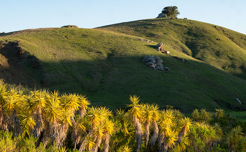
In spring, we love sleeping with open windows. The fragrant fresh breezes keep the house cool, and there’s the occasional coyote howl, hooting owl, or the sound of a nighthawk we enjoy. As the sun begins to show light in the eastern sky each morning—the mornings are getting pretty early these days—Frank and Margaret celebrate surviving another night by perching on the trellis top and begin a sparrow’s equivalent of “Ode to Joy.”

Have you ever really listened to a sparrow’s song? It’s a flat, monotonous “chirp – chirp – chirp.” If left unattended, it can go on for hours. The Queen—who has disdain for anyone having pleasure—soon yells, “Off with their heads.” My obedience is blind, so I stumble out of bed, walk over to the window, throw back the sash, and scare the birds away with my ugly pre-coffee face. That chases them off, but it’s only a while before they’re back and at it again. Sing – scare – repeat.

When the sun does come up, their second act begins. With the new light, they see their reflections in the glass, and like the emu commercial on TV, they start defending their nest. They fly against the window, pecking at the reflection. They fly back and forth along the window top, fighting their perceived intruder. It’s a wonder that my window isn’t perforated. It doesn’t stop until I get up, walk over, pull down the blind, and show my face.

It’s gone too far, so I concocted an evil plan to get even. I went to Goodwill today and purchased an old-timey alarm clock—a bright yellow one. You know—the kind with two bells on top that dances around the end table until you smash it with a hammer. I set the timer for 2 am and hid it in the vines near their nest. I can’t wait for tomorrow when Frank makes a sparrow’s impression of Don Knotts. Meanwhile, I found an old English recipe for Sparrow Soup if it doesn’t work.

Skull Rock - People in Yavapai County love to paint rocks resembling objects to make it more obvious to other people.
Skull Rock – People in Yavapai County love to paint rocks resembling objects to make them more evident to other people.

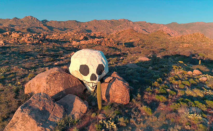
This week’s featured image is called Skull Rock. The people in Yavapai County have a thing about painting rocks that resemble things because people would never figure it out on their own. Unlike our frog, you have to search for the skull. It’s halfway up the Hillside dirt road. It’s hidden behind the elevated railroad tracks, so you have to do a bit of climbing to get a shot of it. One story I read said a Santa Fe engineer originally painted it to tell passengers that the Apaches killed a poacher and left his skull behind to warn others. Then he’d laugh when they reacted as the train rounded the bend and the rock came into view. I can’t vouch for the story’s validity, but it sounds reasonable. You can see a larger version on its Web Page by clicking here.

Until next time — jw

Yucca Hedge Picture of the Week

I’m a morning person. I wake up at dawn’s first light. If I try sleeping in, I just lay in bed with my eyes open until I give in and get up. Then, I work a few hours (writing blog posts, for example) before we have breakfast, and then it’s time for my morning nap. I haven’t needed an alarm since retirement. In fact, when I need to get up early and set a time on my clock, I wake up before it goes off. That’s the story of this week’s picture.

When Queen Anne and I traveled to California a couple of weeks ago, we only had four days, so that’s two days of driving and two days for play. Since I like photographing in the early morning and late afternoon, I planned to be shooting during those times, even if it meant getting up in the dark.

One of the subjects that I wanted to take pictures of was the Santa Lucia Range’s rolling foothills at sunrise. At home, the sun’s been coming up before 7 am, and since California goes on Daylight Savings Time (whatever for?), I should be good if I hit the road by then, so I set the alarm for 6:30.

During the night, I woke at 12:15, again at 1:37, and yet again at 3:30. By the time 5:45 came, I gave up. I got up and dressed in the dark so I wouldn’t disturb Her Majesty. I grabbed my gear and went out to the car only to remember that I forgot my mask, so I snuck back into the room to retrieve it. Getting up earlier than I expected meant that at least I had time to get a Quickie Mart cup of coffee.

Armed with a fresh hot cup of French Roast, I started driving up to the mountain pass. The amount of traffic that I encountered during the fifteen-minute drive surprised me. But then I realized that I was the one on vacation, and other people were going to work. When I reached the top, I found a safe place to park and waited for sunrise, but the sky was awfully dark still.

It took another hour for the sun to break the horizon. I completely misjudged the effects of the time change, and I didn’t take into account that Cambria is about 200 miles further west than San Diego. When the sun finally came up, I began to slowly make my way back down to the ocean stopping and shooting along the way.

Yucca Hedge - The morning sun highlights a hedge of Yucca while shadows remain on the background hills.
Yucca Hedge – The morning sun highlights a hedge of Yucca while shadows remain on the background hills.

This week’s featured image was taken at a ranch only a few miles inland of the Pacific Coast Highway. The owners had planted a hedge comprised of Yucca plants along their drive. They were in full sun while shadows played on the hills behind them. The contrast in light is interesting, and how the spikey Yucca leaves contrast with the rounded hills. The soft morning light also brings out how years of grazing cattle have created terraces in the hills. That’s good because the cattle would otherwise fall over and roll to the bottom. This terracing reminded me of New Zealand, where sheep have changed the landscape in the same way.

I called this photo Yucca Hedge, and you can see a larger version on its Web Page by clicking here. Be sure to come back next week when we add another picture from our time along California’s central coast.

Until next time — jw

Morro Bay Harbor Picture of the Week

The grass is always greener. People who live by the beach travel to the mountains for skiing. Others living in snowy climates come to the deserts to dry out and get warm. What do we desert dwellers do for a change of pace? We go to the beach of course.

After being cooped up in Arizona for the last year, when Queen Anne and I finally got our vaccine shots, we headed off to the left coast for a couple of days. It’s the anti-desert if you will. We drove an extra distance to our favorite part of California because we don’t care much for the giant megalopolis of San Die-Angeles-Barbara. There are too many people there, and they’re all out driving on the freeways.

We drove to what we call—the central coast—the Morro Bay area, and the little hamlet of Cambria. I love the place so much that two out of my three wives spent their first honeymoon there—and the third would’ve preferred it over Utah.

We spent three nights sleeping to the sound of crashing waves on the beach while a fireplace warmed the room. During the days, we put our masks on and enjoyed meals at our favorite diners and discovered new cafes (did you know that there are only four restaurants in the US with a Michelin star?). We strolled along the beach until my calves hurt, drove up to the Big Sur landslide, and peered into the windows of boutiques and galleries. Most importantly—we tasted wines at open vineyards—something we haven’t done since our 2016 Alaska trip. Let me tell you, our local Safeway gets really testy when we set up tables and start uncorking wine bottles for sampling.

But I also needed to photograph something fresh. Last month, I looked at the thumbnails on my New Work index page and realized that everything was brown. No matter how green the saguaros are, the Desert Mountains are brown. Aargh, I’m drowning in the dust. I need water. While Anne was snoring, I snuck out of the room to capture the sunrise, or after dinner, I’d plant her on a bench (she can’t walk when she’s full, so there isn’t much chance that she’d run off) while I walked around the harbor and snapped pictures as I did for this week’s featured image.

I consider Morro Bay’s town to be the southern edge of the famous drive through Big Sur. The Pacific Coast Highway (California 1) returns to the sea here and then continues up through the world’s best coastal scenery section. Here the Santa Lucia Range plunges 2,000 feet into the Pacific Ocean. The highway is temporary here because rock-slides frequently rip the road away from its precarious perch, like this year.

Morro Rock is the stump of a grand old Santa Lucia mountain that time and the sea have worn away. The rock and four neighboring smokestacks are a landmark that you can see from the mountain passes miles away. Morro Bay’s town used to be renowned for the abalone, but that delicacy has been fished out and is now protected. The commercial fishermen have moved on, so mostly private yachts are moored in the town’s harbor.

Morro Bay Harbor - private sail boats and cruisers during a calm spring sunset in Morro Bay, California.
Morro Bay Harbor – private sailboats and cruisers during a calm spring sunset in Morro Bay, California.

In this week’s featured image—Morro Bay Harbor—I tried to capture part of the local fleet using the big rock as an anchor. The setting sun made the cool, moist air glow gold. There’s an unexpected extra between the two boat groupings. In the water near the far shore is a sea otter floating on its back. Only his feet and head sticking above the water. You’ll never see it in these photos or on the Web Site. He’s there, at least I think he’s there . . . well I’m saying he’s there, and you’ll have to take my word for it.

I hope you enjoy April’s change of scenery. You can see a larger version of this week’s picture on its Web Page by clicking here, but if you want to find Waldo—the sea otter—you’ll have to buy an enlargement. Be sure to come back next week for another shot from the Big Sur coast and more fish tales.

Until next time — jw

Blue Tank Wash Picture of the Week

Along U.S. Highway 93, between Congress and Wickenburg, are a set of peaks that I’ve had my eye on for the last five years. They aren’t named because they’re slightly greater than a line of hills. Their color is the same as the surrounding desert, except they have a basalt mantle along the top. Sometimes the darker capstone looks like a shadow on the hilltops.

They’re generally aligned in an east-west direction, with the Hassayampa River on the west and the Blue Tank Wash on the east side. As they face south, there never seems to be a flattering light on them. The other challenge that I have is getting all four peaks into a frame. Even from the highway (3 ½ miles away), they only fit in with a wide-angle lens. That means that all of the homes, ranches, and construction lining the Hassayampa would be included in the photo. So I decided to get closer and pick them off one-by-one.

Two old mine roads radiate out from Wickenburg (Rincon Road and Constellation Road), and connecting the two is another path called the Blue Tank Wash Road. This dirt trail runs through the valley on our range’s south side. Late afternoon this Tuesday, I drove Archie up there to see what I could do.

Blue Tank Wash - Two of the four mountains that rise above the Blue Tank Wash Road near Wickenburg, Arizona.
Blue Tank Wash – Two of the four mountains that rise above the Blue Tank Wash Road near Wickenburg, Arizona.

This week’s featured image is the first variation that I liked. I wanted shadows to show texture and depth, so I shot this from the third peak looking west at the second. I was fortunate to find some sunlit saguaro growing in reddish soil to place in the foreground for scale. The bright spot gives balance to the dark peak in the background. I call this image Blue Tank Wash.

You can see a larger version of Blue Tank Wash on its Web Page by clicking here. Be sure to come back next week for another of my images from the small mountains above the Harquahala.

Until next time — jw

Eagle Eye Cliff Picture of the Week

There’s trouble brewing for me. In this case, it’s a good problem—it’s mischief, really. My conflict is a clash between my annual wanderlust and self-preservation. Sitting on each of my shoulders is an angel and a devil (they’re a metaphor, I don’t really see them, so don’t send a paddy wagon after me). The good one tells me to take the long-term view, while its counterpart tempts me with immediate gratification.

Arizona’s winters come in two parts; cold and wet. They’re relative, of course, nothing like what you see in other parts of the country, but hey, it’s what we’re used to. During the cold period, our weather drops in from the Gulf of Alaska. The second half of our winter is wet because the incoming storms originate over the Pacific. In between these mini-seasons, high pressure settles over the State, and we have warm, sunny days and cool evenings. This period of ideal weather can last from one to six weeks. Last year, we skipped the wet part and went straight to summer.

Last week we had a cold front move through our state with high winds and cloudy skies. It left us and went to Texas, and you can see what happened there. But the second half of the week was sunny and clear. The air was so clean; you could make out boulders on distant mountains. I immediately knew that this is our mid-winter lull. I say we should close the Arizona border so outsiders don’t find out why we live here.

Thursday morning, I took my cup of coffee out onto the back of the deck, and I got that familiar feeling in the pit of my stomach. I need to be on a boat somewhere with a fishing line tied to my big toe while I nap in the sun. This is my annual spring wanderlust, and I want to go somewhere—anywhere. I’ve had enough of winter; I’m ready for adventure.

But, we still have this global plague to deal with. Queen Anne and I have received our first vaccine dose, and next week, we get the second. However, that isn’t a Get out of jail free card. We still have to constrain ourselves. I don’t know how much more willpower I have. I’m really ready to flick the angel off my shoulder and drive to the coast to taste the new wines, visit some Santa Fe galleries, or explore Utah’s Henry Mountains, anyplace but Aguila.

Eagle Eye Cliff - The cliffs on the south side of the Eagle Eye Mountains shows that there is limestone foundations under the lava.
Eagle Eye Cliff – The cliffs on the south side of the Eagle Eye Mountains show limestone foundations under the lava.

But since we’re still stuck in Aguila, let me show you this week’s featured image. I call this one Eagle Eye Cliff. It’s from the same pair of mountains as we’ve explored for the last couple of weeks. The two peaks are the eastern end of the Harquahala Range and are dwarfed by their big brother next door.

I’ve already talked about how the Eagle Eyes are covered in lava, but you can see a limestone foundation underneath in this shot. I don’t know if the white cliff is the remnant of an old reef or the volcanic stone shielded it from erosion. To me, it looks like sloppily done chocolate icing on a white cake. That’s barbaric. Everybody knows that white cake should have caramelized pineapple on it.

You can see a larger version of Eagle Eye Cliff on its Web Page by clicking here. Be sure to come back next week, and I’ll show you the final shot that I liked from my outing in Aguila.

Until next time — jw

Resting Santa Picture of the Week

Gather around children because Uncle Jim has some sad news to tell. As you know, my job is to wander the countryside searching for pretty things to photograph, so I’m always on the hunt for interesting subjects along the roadsides. After Christmas, I was out with my camera, and I came across something that shocked me. Out in the desert west of Congress, I found a man—passed out—covered from head to toe in soot. This wasn’t the run of the mill derelict. No, he was our beloved Santa Clause flat on his back among the McMullen Valley creosote.

I don’t know what happened. I rushed to help, but I couldn’t wake him. He smelled of rum-spiked eggnog. There were cookie crumbs in his dirty mustache, and he was heading north judging from the trail of broken candy canes he left behind. I assumed that y’all left him one too many treats, and as he stumbled around in the dark, he tripped over the Harcuvar Mountains, and while he lay there, he slipped into a sugar coma.

A rescue was too daunting for me alone, so I drove home for more help. Queen Anne always knows what to do. As we drove back to the scene, I tried to explain what I’d found. Her typically skeptical response was, “Yeah—right.” (BTW, that’s an example of double positives making a negative. Take that, Mr. Horowitz) When we returned to the field north of Aguila, I pointed and smugly said that I was right, “… as you can see with your own eyes.” She shook her head, gave me one of her patented ESAD looks, and snapped, “Put on your glasses.”

I frowned, then walked back to the truck and grabbed my readers. When I took a second look, I was humiliated—again—and quietly thought, “Oh no, it’s just a big rock pile.” I turned towards she-who-knows-all, and in a voice that would have made Emily Litella proud, I mumbled, “Never mind.”

Resting Santa - After a night of carousing, Santa tripped over the Harcuvar Mountains and passed out in the McMullen Valley.
Resting Santa – After a night of carousing, Santa tripped over the Harcuvar Mountains and passed out in the McMullen Valley.

And so begins the New Year. Santa was obviously too indisposed to bring worldwide immunity from Covid 19. We still have to cope with the virus by ourselves, as we did last year. Since Queen Anne and I aren’t old enough and are not front-line workers, we’re considered part of the Useless Third that Douglas Adams describes in his book, The Hitchhikers Guide to the Galaxy. So, we have to wait patiently for our turn with that oversized needle. It could be anywhere from two to six months before we get our vaccines.

Until then, we’ll keep on keeping on—as they say—which means staying close to home and away from crowds. I’m ok with that because I’ve seen some things I want to show you from around our neighborhood. For January—at least—I’m going to catch up with some of these odds and ends. As soon as it’s safe, we’ll be exploring new highways with our usual cast of ne’er-do-wells. Here’s hoping that it will be soon.

You can see a larger version of Resting Santa on its Web Page by clicking here. Next week, I’ll show you another interesting shot from around the neighborhood.

Until next time — jw

Tucson Mountains Sunrise Picture of the Week

I woke up in a very chipper mood this morning. When I put on my jeans, they were so loose that I had to tighten my belt a notch to make things better. My morning routine is to check my vitals before making coffee, and my blood pressure was perfect today. There’s been a great weight lifted off my shoulders, and let me tell you what I think it is. First of all, I finally finished the wood project that’s kept me busy all summer—I’ll show you on Wednesday—and secondly, summer’s finally over—well I hope it is.

Over the past couple of days, clouds have filled the Congress skies, and it sprinkled Friday evening. That’s the first precipitation in months. This morning, our new wall thermometer got below 40º for the first time, and I got to put on one of my bulky sweaters. It keeps getting better—today’s forecast is for snow in the mountains. Yep, straight from summer to winter. Today, the world is better.

My mood is so good; I don’t have any snarky stories about Queen Anne, so let’s go back down to Tucson and see where we stopped for our second November image. Last week, we visited the overlook at the top of Gates Pass before dawn. Believe it or not, I wasn’t the only photographer there. A handful of guys were hanging out with their tripods set up for a sunrise shot when I got there. I’m not usually late to one of these parties, and when I saw what they were getting ready to shoot, I wasn’t impressed—it was more of a sundown kind of shot. After snapping a few other scenes, I hopped in the truck and headed down the road stopping again at the bottom of the pass.

Tucson Mountain Sunrise - The morning sun shines on top of the Tucson Mountains.
Tucson Mountain Sunrise – The morning sun shines on top of the Tucson Mountains.

In this week’s featured image—that I call Tucson Mountain Sunrise—we’re looking back at the overlook. It’s the flat area between the two forward peaks at the bottom of the sunlight. Behind that, you might recognize Bushmaster Peak from last week’s image. Actually, all of it is Bushmaster Peak, but I really liked the western side’s gnarly part. It has the most character. For scale, I found a couple of young saguaros and placed them in the foreground—that means that I was wandering around in the dark, rocky, snake-infested desert to get this shot just for you.

How could you ruin a beautifully quiet moment like this? Well, let me tell you how. Just as I finished my shot and began walking back to R-chee, a guy who was parked nearby in a black late-model Chevy pick-up fired it up, and the distinct sound of a V8 with open headers reverberated throughout the canyon. Now, I enjoy loud race cars as much as anybody, but it has to be in the right context. As this gentleman drove east through the pass, it was obvious that he wasn’t racing—he was making noise just for the sake of noise. Fortunately, after the summit, he rode the brakes downhill, and the bird songs once again filled the morning air.

You can see a larger version of Tucson Mountain Sunrise on its Web Page by clicking here. Next week, we’ll make a morning stop in Saguaro National Park for another photograph in our story.

Until next time — jw