Mount Union Picture of the Week

One day, I’m going to stand on top of Mount Everest—or Chomolungma (Mother Goddess of the World) as the Tibetans call it. I’ll to need some help, so I’m waiting until they finish the escalator, and a Starbucks is open at each of the decompression stations. It’s bound to happen. The mountain is already overcrowded, so we may as well wholly ruin the highest spot on our planet. Everybody should get a chance to experience that majestic view once in their life.

I love standing on mountains, canyon edges, and tall buildings. Standing there and taking in the vista enhances my map of the world. We all carry one deep in our hippocampus. It’s our sense of direction, and we probably developed it long before we fell out of the trees. It’s natural for us to want to know what’s over there and where the lions are. It’s a tool that we have located in the most primitive area of our brain. Like all of our other muscles, our spatial map works better when it’s exercised.

When I travel to the mountains like the Bradshaws, I make it a point to stop at the viewpoints and take a look around. Being the nerd that I am, I love it when the Highway Department has those displays that tell you what you’re seeing. I spend so much time studying them that Anne finally wakes up mad in the car. She thinks that I’ve abandoned her at the curb, which is silly because I would never leave the car behind.

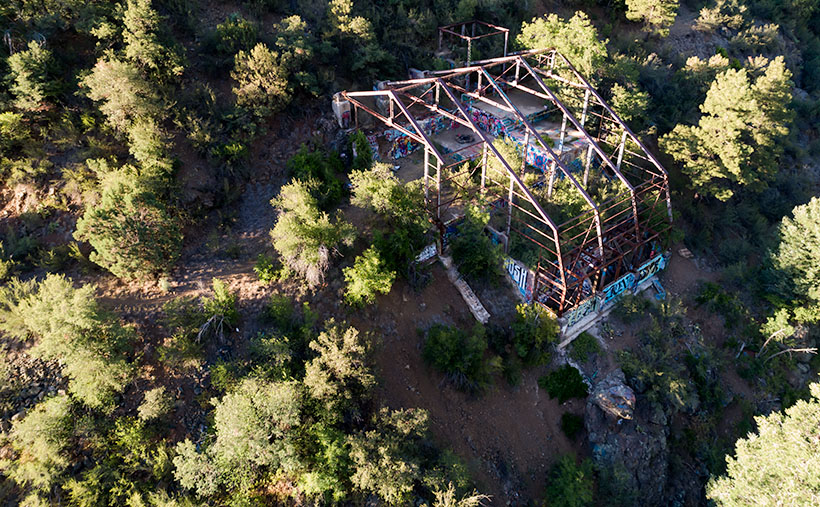
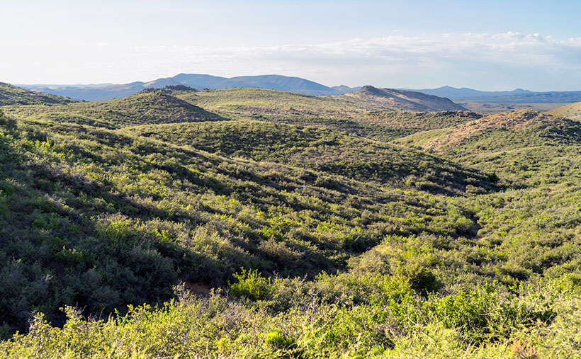
The Bradshaw Mountains—or Wi:kañacha, in the Yavapai language (rough, black range of rocks)—have six peaks over 7000 feet. The two highest peaks, named during the Civil War, are Mount Union (7979) and Mount Davis (7897)—yes, Jefferson Davis. They’re located on the same ridgeline less than a mile apart. On the Senator Highway that Queen Anne and I explored this month, there’s a side road that goes to Mount Union and a lookout tower. On the other hand, to reach Mount Davis, there aren’t any trails—you have to hike cross country from the Mount Union picnic area.

Mount Union - Or rather, the view from Mount Union looking east towards the Mazatzals.
Mount Union – Or rather, the view from Mount Union looking east towards the Mazatzals.

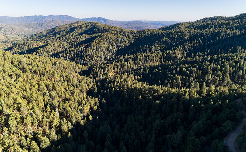
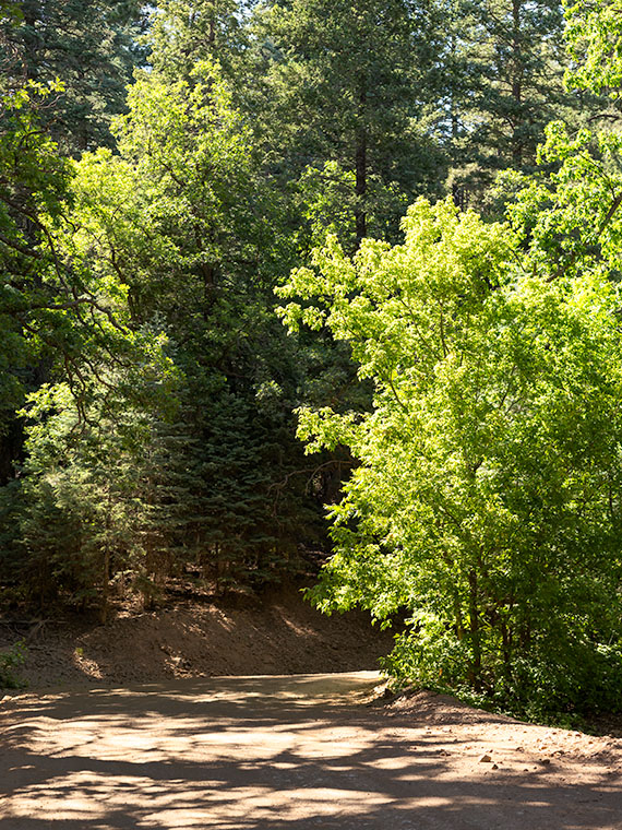
This week’s featured image has a name different than how I usually name my work. It’s called Mount Union, and I called it that because of where I stood rather than the image’s subject. This time, I found a place for the camera where trees weren’t in the way and of the several angles that I captured; I liked this version the best. This photo is of the view looking east, and it not only shows the dense pine forest on the mountain’s top, but it also includes the Black Hills that are east of Cordes Junction and on the horizon is the Mazatzal Range. Somewhere in the valley between the mountains is Interstate 17—Arizona’s primary north-south corridor.

You can see a larger version of Mount Union on its Web Page by clicking here. I hope you enjoy seeing it. Be sure to come back next week when we begin a new adventure traveling more of Arizona’s back roads.

Until next time — jw

Stamp Mill Picture of the Week

Everyone has heard the axiom, “All roads lead to Rome.” Well, not in Yavapai County, they don’t. Over the past couple of years of traveling Arizona’s back roads, I’ve found that they lead to mines, and with good reason. We all have a vision of a dusty prospector sneaking off with a couple of burros to a secret gold mine in the mountains—this is before he became the Arizona Lottery huckster. A man like Jacob Waltz may discover a vein of gold, but it takes a corporation to extract it effectively.

To make a ton of money, you have to move a thousand tons of ore. A couple of burlap sacks strapped to a burro’s back just won’t do. You have to move unrefined earth by wagon, truck, or railroad car. So part of The Company’s infrastructure is getting things to and from the mine site. That is the Phelps-Dodge and the Senator Mine story—and this month’s back road adventure.

While bouncing along the Senator Highway in R-Chee (according to his license plate that’s the correct spelling), Anne suddenly blurted, “There’s a large building down there.” Since my side wasn’t overlooking the cliff, I couldn’t see it, so I stopped the truck and walked back to see the steel skeleton of an old structure. “Cool,” I told her as I climbed back into the driver’s seat. “It’s too early, so we’ll stop on the way back when the light is better.”

Stamp Mill - The ruins of the Senator mine stamp mill are perched above the headwaters of the Hassayampa River.
Stamp Mill – The ruins of the Senator mine stamp mill perches above the headwaters of the Hassayampa River. The mill is visible on Google Earth if you zoom in to the Senator Highway where it crosses the Hassayampa River.

After some research, I found out that the building was a 10-unit stamp mill for the Senator mines. As rock came from one of the three parallel shafts, the miners hauled it to the mill, where the hammers pounded big boulders into small ones. As far as ghost towns go, we struck gold (I couldn’t resist the pun, sorry). Concrete foundations usually are all we find in these places, but since this frame was a steel and not timber, the skeleton survives and gives scale to its size. From the road, I could easily walk down the stairs and wander the four floors. Vandals have decorated the remaining vertical walls for Christmas with colorful graffiti everywhere, so I guessed that we weren’t the first people to find this place.

Kennecott Mine - The Kennecott mining town is preserved in the Wrangell-St Elias National Park in Alaska. This should give you an idea of how a mill looked with the clapboard still intact.
Kennecott Mine – The National Park Service has preserved the Kennecott mining in the Wrangell-St Elias National Park in Alaska. This photo should give you an idea of how a mill looked with the clapboard still intact.

In Alaska, I visited a similar mill at the Kennecott Mine in the Wrangell Saint Elias National Park. At this location, the Park Service keeps that building in an arrested state of decay, and it still has the red clapboard siding. I wanted to show you how the Senator stamp mill might have looked while it was running, so I’m including my Alaska photo.

For this week’s featured image—that I call Stamp Mill—I wanted to show the building and its environment, which is hard to do while standing inside of it. So, I took this shot from the far side of the Hassayampa River Canyon as the sun hung low in the western sky. I was lucky in that the remaining silver paint glowed in the afternoon sun, which makes the frame pop from the background.

You can see a larger version of Stamp Mill on its Web Page by clicking here. I hope you like it. Be sure to come back next week when we present the final image from our drive on the Senator Highway.

Until next time — jw

Road Bend Picture of the Week

Although I’ve tried my best to hold back time, the season has changed,  and it’s summer again in the desert. Summer’s dog days are the worst time to be photographing our arid home. Except for the brief respite at either end of the day, the bright sun and ozone combine to wash the colors away. It’s like seeing the world through a 2% milk bottle—the glass ones, not the cartons. You need polarizing sunglasses to force the blue to show in the sky again.

We desert-rats are nothing if not adaptive. Like all of the other Sonoran critters, we hide in our holes during the day. For example, the Round-tailed Ground Squirrel escapes the day heat in his den by sleeping splayed-out on his back. I do the same thing, and I’d show you photographic evidence except I’d be banned forever from the Internet. The other thing we do is migrate. Even during this pandemic, Highway U.S. 93 was a parade of boats heading north towards the rivers and lakes on this holiday weekend.

When we were deciding on a project for July, Queen Anne and I followed a similar logic. We looked for someplace cooler—trust me, 90º is cooler than 110º. We scoured our maps for a place nearby in the mountains, a location that wouldn’t have crowds yet be accessible. We settled on the Senator Highway that runs from Prescott south into the Bradshaw Mountains.

Road Bend - Bright yellow-leaved deciduous trees obscure what's beyond the road on the Senator Highway south of Prescott, Arizona.
Road Bend – Bright yellow-leaved deciduous trees obscure what’s beyond the road on the Senator Highway south of Prescott, Arizona.

Until this month, I didn’t know why there was a dirt road called the Senator Highway. I imagined that it was a route that our state assemblymen traveled when Arizona’s capital swapped several times between Prescott and Phoenix—foolish me. Instead, it’s just another mine road that the miners built it to transport ore and supplies between the Senator Mine and Prescott. If you’re skilled at navigating the Bradshaws, you can technically get to Congress via the Senator Highway.

I find the pine-covered mountains, like the Bradshaw’s, hard to shoot. The trees get in the way. I mean, how many different ways can you get an image of ponderosa pine tree bark? I hunt for edges—splashes of color, an opening to the horizon, or building ruins. That’s what I’m showing in this week’s featured image. At a bend on the highway, I saw some trees (I believe Arizona Ash) with bright yellow-green leaves shinning in the sun against the duller blue-green evergreens. I liked how they obscured the path. My mind wants to find out what’s beyond. It’s a classic leading-line perspective trick, and I find the dappled shade on the road a bonus. I named the first image for our July project Road Bend because it’s a simple title for a simple photo.

You can see a larger version of Road Bend on its Web Page by clicking here. I hope you like it. Be sure to come back next week when we present another image from the Senator Highway outside of Prescott.

Until next time — jw

Kirkland Junction Picture of the Week

A couple of decades ago, there was a TV ad where a sleepy-eyed baker got out of bed and made his way to his Dunkin Donuts store, and as he made his way, he mumbled, “Time to Make the Doughnuts.” I felt sorry for the poor guy and wished he could crawl back in bed. But, if your business is selling coffee and deep-fried cake to a morning crowd, you gotta’ make some product. You’ve got to work your schedule.

In photography, the quality of light is vital for making memorable images. Pictures that stand apart from the millions posted daily on Instagram. This topic is one that I’ve covered in my writings several times. Any subject looks better when you capture it when the light is warmer, and the shadows are longer—known as the golden hours. Those happen after sunrise when healthy people are still in bed, and before sunset when smart people have sunset cocktails. When I go out on a photo shoot, I try to time my sessions using that light.

The light is even more complicated in Arizona. Because we live in a longitude closer to the equator, that golden hour dramatically shrinks in summers. To further complicate things,  the desert afternoons are too hot for scouting subjects. That’s why I chose the early morning when Fred and I went to Placerita. To get there at the right time, we left before sunrise. Unfortunately, by the time we arrived, the clouds moved in and took away the color, so I made a second trip last week. This time I was on my own because Fred was nursing an old war wound, and Queen Anne doesn’t get out of bed unless there’s a jewelry store involved.

So, in the darkness, I packed my gear into Archie and drove north on State Route 89 with a USB stick full of fresh tunes and a hot mug of coffee in the cupholder. In Yarnell, the sky was bright with a line of clouds leftover from the day before. I watched the color deepen as I passed through Peeples Valley. By the time I arrived at Kirkland Junction, I had to stop so that I could get a shot. After turning onto Wagoner Road—this month’s back road—there was enough light to show color on the ground. I lined up the scene so that some abandoned structures were under the pink clouds.

A set of abandoned buildings at Kirkland Junction underneath beautiful pink clouds.
This week’s photo is of a set of abandoned buildings at Kirkland Junction underneath beautiful pink clouds. The mountain in the background is Kirkland Peak.

That’s how I took the last photo in June’s series. I call this week’s featured image, Kirkland Junction. Interestingly, this month we showed the subject of this month’s journey from the end to the beginning. We began the month at our destination—Placerita-and worked to the road’s start. It’s like that movie Momento.  You knew the protagonist was guilty of the murder right up to the story’s beginning that was at the film’s end. I was so confused by the time the movie was over; I had to think about it for weeks. I hope that I haven’t done that for you.

You can see a larger version of Kirkland Junction on its Web Page by clicking here. I hope you enjoy it. Next week, we’ll begin a new journey on a different, less-traveled highway. I hope you’ll join our expedition.

Until next time — jw

Seal Mountain Picture of the Week

I wouldn’t have made a good prospector if I had lived during the Weaver Mountain mining boom. Since it is Father’s Day, a quote from my dad seems especially appropriate today. “You’re nothing but a lazy bastard, and you will never amount to anything.” Thanks, dad. I’ll cherish those words forever. He’s right, though. I don’t even like to water our flowers much less pick at a mountainside. In last week’s post, I was shocked to see in the photograph of my hand, a callous below my ring. Where did that come from—I haven’t touched a hand tool in decades.

If mining is off my list, what else did men do to earn wages back then? To find out, I continued my exploration of the Weaver Range east side by following the other side-roads near Placerita. This week I drove the Wagoner Road down to the Hassayampa River. I’ve never seen that area, and besides, I might get different scenes for my drone film. I struck pay dirt (sorry for the mining metaphor).

The Wagoner Road descends the east slope of the Weavers into a river valley where the Hassayampa flows above ground. As expected, where there’s surface water, there’s farming—or in this case ranching—big ranches. They’re stacked along the river one after another. They have well-maintained fences, impressive gates, and lots of black cattle (although I did see a herd that had Wagyu markings). The valley reminded me of north Scottsdale when it was mostly Arabian horse farms. It would be an ideal place to live except for grocery shopping. There are only two ways out, the 38-mile road back to Kirkland Junction or crossing over the Bradshaw Mountains on the Senator Highway (Wickenburg is only 20 miles distant in a private aircraft, which is possible given the size of these estates).

Seal Mountain - A remote mountain only seen in an obscure valley is the model that was used on the Arizona emblem.
Seal Mountain – A remote mountain only seen in an obscure valley is the model that was used on the Arizona emblem.

Since I was scouting new views of the Weaver peaks, I found a doozy. It’s the mountain that is in the background of this week’s featured image that I call Seal Mountain. Every Arizonian should know this mountain by heart because it was the model used for the Arizona State Seal. In 1912, who knew it existed? The only place you can see this peak is from the ranches in this remote valley. I’m impressed, however, that my local mountain range is represented on the Arizona seal.

The Arizona Seal - If you squint hard, you can see the similarity.
The Arizona Seal – If you squint hard, you can see the similarity. Personally, I would have chosen Four Peaks.

So, could I have been a rancher instead of working in a mine? MMM—maybe not. That kind of work still involves toiling with shovels, rakes, other hand tools, and even possibly riding a horse. Horses don’t like me. The last one that I road said, “Oof,” when I got on. Let’s take a closer look at that state seal—shouldn’t there be a programmer or a Web designer on it? Come to think of it, there isn’t even a real estate agent, and that’s the number one Arizona job.

You can see a larger version of Seal Mountain on its Web Page by clicking here. I hope you enjoy it. Come back next week to see what else we found along the road to Placerita.

Until next time — jw

Placerita Hills Picture of the Week

While having this morning’s coffee, I sat on the front porch and watched the sunrise over the Weaver Mountains. That’s the best view from my house, but there are still homes and trees in the way, so I can only see their tops unless I walk down to the end of the street. Since the elevation here is 1500’ higher than the Phoenix basin, the mornings are still cool—even in June. Because my porch faces east, all of that pleasantness comes to an abrupt halt the second the sun clears the horizon. Then I’m forced to retreat to the back where I have a spectacular view of my neighbor’s shed.

When we moved here almost five years ago, I knew nothing about the Weaver Range other than their name. With time, I learned more about their secrets as I researched the subjects I photographed. I fear that by the time I run out of film, I’ll become a sort of grizzled old Gabby Hayes wandering the Wickenburg streets, wearing a torn cowboy hat, a mouth full of chaw, and spinning yarns about mountain ghosts, so the tourists will give me loose change.

The Weaver’s have been at the center of my attention for a couple of months now because they’re the subject of my third drone video that I’ll finish in a couple of weeks. For the video, I made a list of points to film, and I’ve grappled how to describe the range best. On the way to the Prescott Costco last week, I blurted to Anne, “They’re like a horseshoe wrapped around Peeples Valley.” She said, “Huh?” I probably should have started with some context. Then I came up with a better metaphor. They’re more like the palm of your left hand—not the Michigan one.

The Weaver Range - The geography of the Weaver Range can be summed up on one hand, but you have to use the correct one.
The Weaver Range – The geography of the Weaver Range can be summed up on the one hand, but you have to use the correct one.

Use your imagination. Peeples Valley is the depression in the center, and State Route 89 is your life-line ascending from your wrist up Yarnell Hill to the little town at the pass. The Weaver’s tallest peaks are along with the thumb, and where gated communities of summer homes are. The desert wall (the northern boundary of the Sonoran Desert) is along your wrist. The area under your little finger represents the lower eastern peaks—more like rolling hills. The Hassayampa River separates the Weavers from the Bradshaws. The area that we’re exploring this month is at the base of your little finger.

Placerita Hills - The east flank of the Weaver Range are hills than tall peaks.
Placerita Hills – The east flank of the Weaver Range are hills than tall peaks. On the distant horizon is Weaver Peak which is on the other side of Peeples Valley, and is the range’s tallest peak.

The east flank of the mountain range doesn’t have any soaring peaks, at least not when you drive in from Peeples Valley. The mountains are more like rolling hills, as seen in this week’s featured image that I call Placerita Hills. To get there, you have to drive up a long gradual incline. The hilltops have granite outcrops that are like miniature versions of eastern and southern peaks. In the photo, the dense vegetation is very evident and is a mixture of Manzanita, Scrub Oak, and some others that I’m not able to name. Unlike the desert floor, there’s no space to walk, and it’s easy to understand why cowboys wear chaps. The mule deer that we saw bounced over the brush instead of running through it. It’s incredible to me that the area’s ranchers can raise cattle here.

You can see a larger version of Placerita Hills on its Web Page by clicking here. I hope you enjoy it. Come back next week to see what else we found along the road to Placerita.

Until next time — jw

Placerita Post Office Picture of the Week

It was lust for gold that lured men to the Weaver Mountains in southern Yavapai County. They heard stories of miners plucking nuggets from the ground and, in just a day, returning to camp a wealthy man. The fever for gold outweighed the risks of hostile Indians, treacherous mountains, poisonous snakes, and oppressing heat from the relentless sun.

Prospectors discovered several veins of the precious mineral with Rich Hill at their center. Pauline Weaver’s party started the rush when they accidentally found placer gold on the hill’s top. Boomtowns sprung up surrounding Rich Hill. The camps in Stanton, Octave, and Yarnell all had ore-bearing mines. There were so many claims on the hill; it’s a wonder that prospectors didn’t dig into each other’s tunnels. But it only took 20 years for the gold to dry up; as a result, when Anson Wilbur Callen arrived in the 1880s, he decided to prospect somewhere else.

If you flew a small airplane due east of Yarnell, you’d see a geographic anomaly. Instead of the regular distribution of peaks and hills in the Weaver Range, there’s a 2-3 mile gash between Antelope Peak and Rich Hill. From Yarnell, it runs northeast, and it looks like a score on the top of a loaf of bread. It’s very evident on a topo map or Google Maps.

There’s a natural divide in the gap’s center, and Antelope Creek drains south along the east flank of Rich Hill. Arrastre Creek flows in the divide’s north side (Arrastre is the Spanish word for a drag, as used for mining). Anson set up his camp where Arrastre Creek flows out of the canyon.

By accounts, Anson Callen was a big man and weathered beyond his age. Locals called him Old Grizzly at the age of 40. When he set up camp, his initial task was to create a reliable water source, so he dammed up the creek. As he dug a five-mile water ditch to his base, he uncovered two pieces of gold that earned him $550. There are more stories of finding large gold nuggets in the area—one of which was four pounds that the assay office valued at $900 ($107,792 in today’s market). Before Anson knew what had happened, the town of Placerita sprung up around his claim.

On Tuesday morning, I dragged my friend—Fred—out of bed, and at 5 a.m., we drove his Toyota FJ into the sunrise to find the ghost town of Placerita. As I’ve written, real ghost towns rarely have any remaining artifacts. Maybe there’s a pile of timber or a concrete slab, but never an intact building. My research showed that Placerita had a standing stone cabin, and I needed to photograph it.

Ruins in the Woods - From the roadside, we could see the remains of one of the town buildings, but we couldn't see an easy way to get to it.
Ruins in the Woods – From the roadside, we could see the remains of one of the town buildings, but we couldn’t see an easy way to get to it.

When we got to the area, we drove by a shed with a collapsed roof, but the brush was so thick that we couldn’t find a path to it. Instead, Fred drove down to the creek crossing and parked in an apparent campsite. We intended to hike up the creek, find the buildings, and photograph the ruins. Indeed, they were built along the banks. We soon discovered that walking in a dry creek bed wasn’t the best thing a couple of septuagenarians should do—especially a pair that has a hard time walking on carpets. We struggled for what seemed like a couple of miles, occasionally falling on the rocks and swatting at attacking insects.

Placerita Post Office - The 30 townspeople were served by this Post Office from 1896 to 1910, when the gold ran out.
Placerita Post Office – The 30 townspeople were served by this Post Office from 1896 to 1910 when the gold ran out.

Finally, we gave up and started back to the truck, but instead of the creek, we found a cattle track that had boot prints. We followed it to a clearing where—you guessed it—we found the collapsed building. We spent some time shooting photographs from different angles, including this week’s featured image called Placerita Post Office. About half the walls were standing, but the timbers were full of termites, and that finally caused the roof to collapse.

We never found the stone cabin—or at least we thought we hadn’t—but after I got home and did some further research, I found a photo caption that said, “It has been reported that the roof has collapsed since this picture was taken.” We did reach our goal; it’s just ten years too late. I also found out that the stone building that we shot was the town’s Post Office—built in 1896 and closed in 1910. As a federal building, it was built more durable than the rickety shacks that the miners cobbled together. It makes sense that it outlasted the rest of the town.

You can see a larger version of the Placerita Post Office on its Web Page by clicking here. I hope you enjoy it. Come back next week to see the work I’ve shot along the road to Placerita.

Until next time — jw