Thumb Flat   Picture of the Week

With a basic knowledge of native Arizona plants and observational skills, it’s easy to tell what elevation you’re at in our state. Maybe only Florida is easier because the entire state is below 350′. I’ve written before about how State 48 has all but two of the world’s climate zones; sub-tropic and tundra permafrost. So all you have to do is look at the bush you’re standing next to you for a clue.

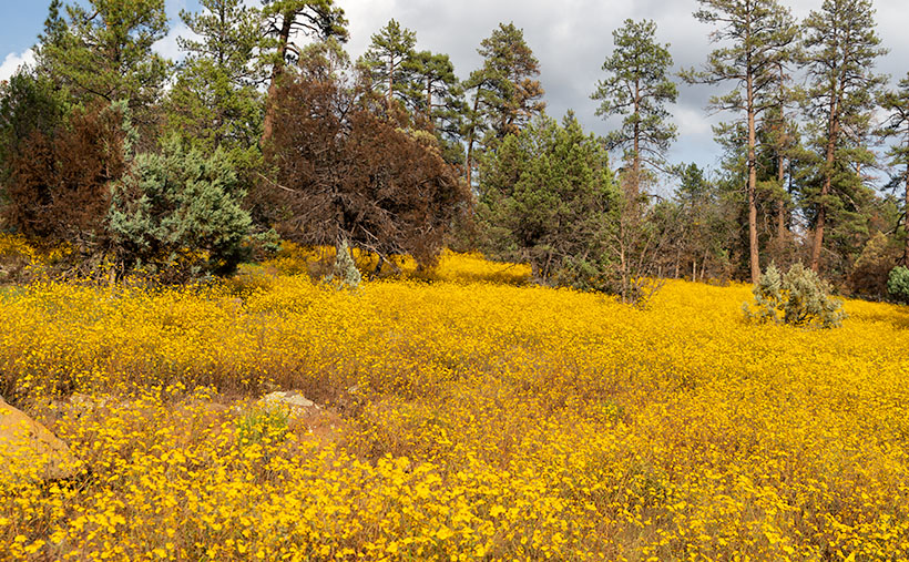
For example, compare last week’s picture to the one that I posted today. The tall ponderosa pines you see in Yellow Field thrive at altitudes over 6,500 feet. While the pinion pine in this week’s image—Thumb Flat—is the dominant plant between 5,000 and the appearance of tall pines. My rule is only a rough generalization because there are microclimate pockets all across the state. I can name two places off the top of my head as examples; Palm Canyon in the KOFA Range south of Quartzite and the east slope of the Poachie Range south of Wikiup. The state’s only native palms grow in a mountainside crevice at the first location, and the latter has saguaro and pinion pine intermingling on its slopes.

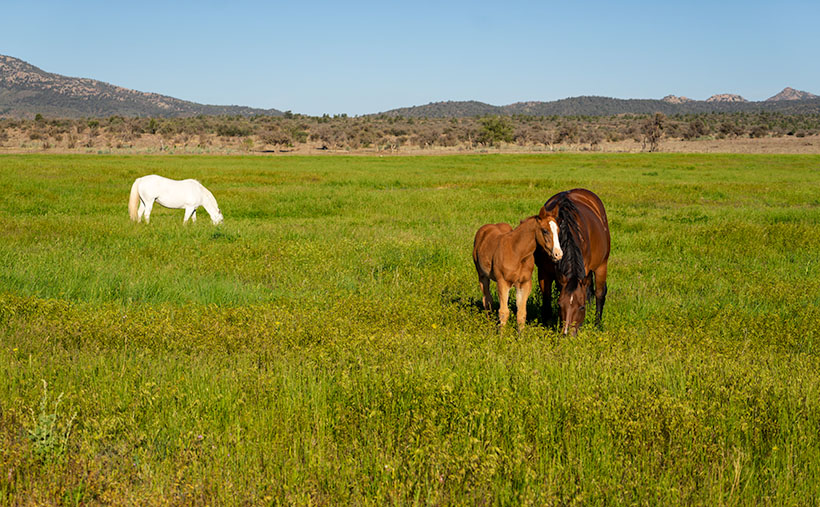
When Queen Anne and I visited Williams, it was only natural as we drove down the south slope of the dormant volcano to see ponderosa pine replaced with stands of juniper. As the White Horse Lake Road descended even lower, the juniper became sparser. By the time we reached Thumb Flat—as it’s called on the map—individual trees had stood alone in the wildflower-covered fields.

Thumb Flat - A beautiful alligator juniper stands in a wildflower covered field.
Thumb Flat – A beautiful alligator juniper stands in a wildflower-covered field.

Here I spotted this beautiful alligator juniper, which made me stop Archie and get its portrait. I think this specimen would be a prized possession in anyone’s garden. Probably the only reason this tree isn’t already in somebody’s front yard is that it’s in the middle of the Kaibab National Forest.

In this week’s featured image that I call Thumb Flat, I like how the foreground is darker in color from being in the shade of a cloud. It contrasts nicely against the bright white background cumulus clouds. The wildflowers are the same as in last week’s image, but you can see how much more dull they are when they’re not in direct sunlight. In this case that’s OK because they’re not the subject here—this week, they’re only playing a ‘walk-on’ part.

You can see a larger version of Thumb Flat on its Web Page by clicking here. Next week, we turn onto another side road, so come back and see where that road ends.

Until next time — jw

P.S. If the picture is not showing up in your email version of this post, you can click on the article title (Thumb Flat) to open the Web version of this post.

Yellow Field Picture of the Week

The four roads out of Williams, Arizona, point to the four compass directions. To the east and west is Interstate 40—the modern-day version of Route 66 and even older trails that the First Nation People used. To the north is Arizona Route 64—the busiest route to the Grand Canyon. The least traveled road goes south and is Coconino County Route 73, or Perkinsville Road. This is the back road that we’re using for this month’s project.

If you’ve never heard of the town of Perkinsville, it’s understandable. It’s been a ghost town ever since its lime quarry shut down in the 1950s. Several families still live in the Perkinsville area, but its biggest claim to fame is the Verde Canyon Railroad stop, where they turn the train around. Also, if you’ve ever bought Arizona red flagstone, it comes from neighboring quarries between Drake and here.

To get to our road, you take 4th Street south from downtown Williams, to where it changes name at the town’s edge. The paved two-lane road winds through Cataract Canyon past a handsome masonry dam and reservoir. The railroad built it to supply water for the steam trains, and the name, Santa Fe Reservoir, has stuck. Shortly after, the road climbs up and over the east shoulder of Bill Williams Mountain, and you’re quickly in a ponderosa pine forest.

Within minutes you reach the road’s crest, and open pastures appear. Here you’ll see hiking trail signs that direct you to a trail that climbs to the mountain’s 9253-foot summit—should that be something on your bucket list. Further along, there’s another side road that goes to the Williams Ski Area. I didn’t even know that Williams had a ski area.

As Anne and I drove along the downhill slope, juniper replaced the tall pines, and large fields of yellow wildflowers were all around us. The good rains that we’ve had this summer have been beneficial for the flowers. We continued south on CR 73 until we turned east onto White Horse Lake Road. We were out after a weekend of rain, and although its surface is packed gravel, it’s navigable even for a 2wd sedan.

Yellow Field - The abundant monsoon rains that we've had have been especially good for the wildflowers.
Yellow Field – The abundant monsoon rains that we’ve had have been perfect for the wildflowers.

Since the flowers were so profuse, I wanted to take their picture with the sunlight beaming down on them, but a cumulus cloud got in the way every time I stopped Archie. I played this cat-and-mouse game several times before I captured this week’s featured image. I call it Yellow Field. I don’t know the flower’s actual name, but it’s the same weed we’ve been spraying for the past month in our yard. Wildflowers is weeds—who’d have thunk?

You can see a larger version of Yellow Field on its Web Page by clicking here. Next week, we’ll show more of the scenery we found on White Horse Lake Road. Come back then.

Until next time — jw

North Weaver Shadows Picture of the Week

This is Augusts’ final post; the doves are skittery, there’s football on TV, and my astrological markers are lining up. Hmm—what do you think Mother Nature’s trying to say? For me, these are all precursors to summer’s end and the time when Arizonans will once again emerge from their dens. If we were smart, we’d form a committee to dress up a ground squirrel in a tux, call him Congress Cecil, and have him predict how many weeks of extreme heat warnings remain. The days will still be hot for another month, but soon the evening temperatures make being outdoors tolerable.

I should explain the skittery doves and astrological marker. September 1 is our state’s dove season, so doves begin to move to where the houses are because they have a better chance of not being shot. The day after hunting season closes, the doves return to the open desert and won’t be heard from until they get horny in the spring.

And yes, just like the ancient Anasazi, I have a special marker that precisely tells me when the spring and fall equinoxes happen. I didn’t carve a light-piercing spiral in sandstone as they did; instead, I use Bruce’s—my across-the-street neighbor—roof. Its ridgeline runs east-west, and on the mornings of the equinoxes, the sun comes up from its peak as I enjoy my coffee on my front porch. Y’all should come to join me on September 22. It would really freak out Bruce to see hundreds of people staring at his house at dawn.

North Weaver Shadows
North Weaver Shadows – With help from the setting sun, cumulus clouds cast shadows on the Weaver Mountains.

As I said, this is the last image in my August cloud project. The monsoon took a vacation this week, so the sun’s brought the heat back. It’s had a chance to dry out, and now the yard’s full of weeds. But, Arizona Highway 89 is lined with orange poppies, and I spotted a couple of Palo Verde trees with yellow blossoms. It’s like spring again, and I’m getting that familiar wanderlust feeling.

Our monsoon will be back with a vengeance in a couple of days. There’s a hurricane traveling up Mexico’s west coast, and there’s a good chance it will come up the Gulf of California. When storms do that, it brings more than isolated showers—instead, the whole state gets soaked.

This week’s cloud picture kind of shows the weather’s dry break. The sky is clearer with scattered cumulus clouds. It also shows that it’s not just the puffy white sky-meringue that is pretty, but their shadows make the mountains more interesting. In the photo that I call North Weaver Shadows, we see cumulus cloud shadows cast on the north edge of the Weaver Mountains with help from the setting sun. This is my favorite image in this series because my familiar mountain range is different—more interesting. For your viewing pleasure, I also hid a black cow grazing on the desert floor somewhere in the picture—if you can find it.

You can see a larger version of North Weaver Shadows on its Web Page by clicking here. Next week, I’ll start a new September project. With the coming weather change, I hope I can get some shots in by then. So, be sure to come back and see if Dudley Duwright rescues Lit’l Nell from the railroad tracks in time (if you think about it—if he’s not in time, it’s not much of a rescue—is it?).

Until next time — jw

Burro Creek Canyon Picture of the Week

There is the phrase Grand Canyon State on every Arizona license plate—it’s our state slogan. I find it ironic that the biggest thing we brag about is something that eroded millions of years ago. Sure, we have the World’s biggest hole in the ground, but there are many other sights in Arizona that we can be proud of.

I think that the slogan can have two meanings. First is obvious; the Grand Canyon State—we’re the state where the Grand Canyon is. The other interpretation that I see is; the grand canyon state—meaning that we’re a big state with lots of canyons within it. It’s true. We have pretty canyons all over the state. There’s the big ditch, of course, but there is also Canyon de Chelly, Salt River Canyon, Oak Creek, Madera Canyon, Sabino Canyon, and too many others to list here. Actually, I looked for a comprehensive list like the one I found for our mountains, but it alluded me.

Burro Creek Canyon - An awesome view that most people miss because they're in a hurry to get to Vegas, or back home.
Burro Creek Canyon – An awesome view that most people miss because they’re in a hurry to get to Vegas or back home.

Our stop this week along Highway US 93 is Burro Creek Canyon. The view of the canyon is spectacular, but it’s hard to see from the road. The bridges over the chasm are short, and the walls are high, so unless they’re in a semi-truck, most people don’t get to see over them—a gripe I share with the new bridge at Hoover Dam. The highway department didn’t build a scenic overlook, and you’re not supposed to walk across the bridge. You can take in the vista in my shot by parking in an unmarked lot accessible from the northbound lanes. Then, a short hike up a trail will get you to the south wall.

Canyons have always been important to Arizona travelers because you usually find water in them. After all, that’s how they were carved. Burro Creek is one of those exotic desert waterways that always has water (in normal years). As you can see in my shot, a couple of surface pools reflect the blue sky even during our extended drought. That makes the creek a reliable water source for wildlife, cattle, and even the wild burros that are pervasive in western Arizona.

I’ve considered adding canyons to my projects list. There’s enough subject matter to fill another of my book fantasies. However, my to-do list already has mountains, old towns, historic hotels, deserts, farms, Colorado Plateau, and the Grand Canyon on it. How do I prioritize them? Where would I ever find the time to photograph them all? I’d have to clone myself because my time is getting short, and the list keeps growing.

You can see a larger version of Burro Creek Canyon on its Web Page by clicking here. Next week, I’ll turn the camera around for a nice look in the other direction.

Until next time — jw

Skull Valley Station Picture of the Week

It’s been a while since I pointed my camera at an old building. The last time I did was before we all got locked up last year. I did publish that shot of Oatman’s empty streets last year, but that image spoke about desertion rather than historic buildings. I guess I missed this genre because after I shot the train depot in last week’s photo, I hung around and worked on other Skull Valley buildings.

Shooting architecture is a different discipline than nature photography. That’s because lens distortion is more obvious when you’re shooting boxes. That’s why view cameras have movements that allow the artist to correct for perspective distortions. These days, you can correct that in Photoshop—to a degree. A photographer can use a couple of other secrets to minimize camera distortion that I could reveal to you, but then I’d have to kill you.

As I grow old, history becomes increasingly important to me, so I wish I could tell you the story behind each of the buildings I shoot. However, most of my subjects are ordinary, and they’re only historic because they survived the wrecking ball. If I were a better researcher, I could visit the local museums and city halls to uncover records. Unfortunately, I’m not going to because I’m lazy. If it doesn’t exist on Google, then it never happened.

Skull Valley Station - Located on Iron Springs Road in Skull Valley on the north side of the Peavine tracks.
Skull Valley Station – Located on Iron Springs Road as it winds through Skull Valley just north of the Peavine railroad tracks.

Take this week’s featured image, for example. Up until this year, tenants used this building as a feed store. I guess that the pandemic was bad for their business, and they closed shop early this spring. I don’t know when someone last sold gas here, but the pump is set to 33 cents per gallon. I did find this article from The Daily Courier that suggests that a previous owner—Bob Colbert—didn’t know he owned a service station until he uncovered the original sign under layers of paint. Now someone has slapped more paint over the sign again (I wonder what happened to the other two pumps).

We drive by this building each month on our way to the Prescott Costco. It’s on the right immediately after Iron Springs Road crosses the Peavine tracks I talked about last week. I never stopped to take a picture because of the feed signs, and there were always newer vehicles parked outside. They kinda ruined the old-gas-state motif. This time with the early-morning light in the cottonwoods and dappled on the orange façade, I took time to shoot the station from several angles. This week’s featured image is the version I liked best. I called it Skull Valley Station. What else could I call it?

You can see a larger version of Skull Valley Station on its Web Page by clicking here. We’re going to hang around Skull valley for another couple of weeks, so come back and see what else caught my attention.

Until next time — jw

Skull Valley Depot Picture of the Week

I’m not considered a sociable person, so you may be surprised that I joined a car club back when I was a younger man—more than half my life ago (oh jeez, where has it all gone). This club’s existence was based on owning a particular brand—which one isn’t important for my story—but the club member’s general attitude was that no one should drive one of these cars because the mileage brought down their value. Insane, I know. Despite that, the club put on well-attended events like parties, tours, meetings, and track days.

The club event that drew the most participation was their annual progressive dinner. If you’ve never heard of that, it’s a three to seven-course dinner served at the volunteers’ houses who prepared each course. So we’d meet at the appetizer house, have a glass of wine, and when the food was all gone, we’d jump in our cars and drive to the next course. The club paid for the food and a couple of jugs of Carlo Rossi wines, and members paid a flat per-head attendance fee. The club made a lot of money. Things were different then. Phoenix had few roads north of Northern Avenue, and traffic was nil on Saturday nights, so by the end of the evening, the drive between houses turned into a Targa Florio race. Half the club would wind up in the slammer on DUI charges these days, and the insurance companies would cancel their policy.

Now hold that thought in the back of your head while I talk about the other part of another one of my grandiose ideas. I’ve written before about the trains that pass our house. They run less than a half-dozen times each day (and night), so the tracks are empty most of the time. The route runs from Phoenix to the northern town of Ash Fork, and it has so many twists and turns that it was dubbed The Peavine Line when it opened a century ago. The tracks run through the heart of Arizona’s historic gold mining country.

Historically our little train used to carry passengers with depots in Phoenix, Wickenburg, Congress, Kirkland, Skull Valley, Prescott (now bypassed), and Ash Fork. Most of the town’s stations are still there in one form or another. And—unlike the routes between Phoenix to Tucson and Phoenix to Yuma—there is some interesting backcountry scenery and at least two climate zones along the journey.

Skull Valley Depot - The townspeople of Skull Valley have put their abandoned depot to good use as a local museum.
Skull Valley Depot – The townspeople of Skull Valley have put their abandoned depot to good use as a local museum.

So, after my photo outing where I shot this week’s featured image in Skull Valley, I began to fantasize about having a progressive dinner—on a train. The trip would start in Wickenburg (or maybe Sun City West), then make scheduled stops where the old stations are. At each stop, you could peruse the local museum, enjoy the designated course, spend money on useless trinkets in the gift shop, pee, and get back on the train. Between stations, the guests could taste wine samples (from Arizona vineyards?) and purchase bottles that they would pick up at the evening’s end. At the end of the line, the train would make a leisurely two-hour trip back to the station. The night will have fallen by that time, and guests would enjoy non-alcoholic beverages to sober them up.

I only know of two train excursions in Arizona; the Verde River Line and the trip from Williams to the Grand Canyon. There once was the White Mountain steam train, but that closed a long time ago, and Durango bought the engine (which fell off the trailer along US 89—however that’s another story). I think there’s plenty of market for another train ride in our state, and the dinner would make it a unique experience. Think of it as a dinner cruise on rails.

If this lame-brain idea sounds good to you, then it’s yours. On the other hand, if you feel it’s a stupid idea, I never said anything. My brain hurts too much to work on stuff right now. I’m too old and penniless. Besides, it’s time for my nap.

You can see a larger version of Skull Valley Depot—the picture that set my brain on fire this week—on its Web Page by clicking here. Be sure to come back next week when we continue with another Skull Valley artifact.

Until next time — jw

Grazing Horses Picture of the Week

I’m a flexible person. Not in the word’s literal sense. You’ll never see me wearing my onesie running and flopping about on some rubber mat at your gym (try to get that picture out of your mind soon). I mean that when I’m presented with valid alternatives, I can change my priorities—like with this week’s image.

I got out of bed extra early this Thursday to drive up the hill and take sunrise pictures. I knew what subject I wanted to shoot and had planned my outing before I ever got out of bed. When I left the house with my cameras and thermos of hot coffee, the light was beginning to break in the east, and I knew that I could get to Skull Valley just as the sun rose over the Sierra Prieta Range. After all, this is the way we go to Prescott all of the time. The trip was as routine as a run to the corner store for a pack of Chesterfields.

I was right, of course. As I hauled my equipment out of the car, there was no one around, not even on the busy highway. Only me and my subject were there, so I quietly got to work. Fifteen minutes later, I put my junk back into the truck, and I began the drive home.

As I drove south, I wondered if the Ranch House Restaurant would be open when I got to Yarnell. They don’t open until seven, and that’s only on the weekends. It’s a good breakfast stop. Then, as your mind wants to do, I began deciding what to order. I love their ham and eggs, but their serving is so large, the ham comes on its own plate. I usually take half of it home and make another meal from it. I decided on chorizo and eggs—with an extra dash of cayenne cause I like it spicy.

I happened to be driving past the horse ranches in Peeples Valley as the great breakfast debate raged within my head. Suddenly, I felt that something was out of place, so I had to come back to earth to discover what caused the disturbance in the force. Out in the west pasture was a brilliant white horse, and it stood out like a search beacon in the tall green grass. My hunger wrestled my creativity briefly before I stopped Archie. Breakfast would wait.

Grazing Horses - Domestic horses grazing the still green grasslands in Peeples Valley on an early spring morning.
Grazing Horses – Domestic horses grazing the still green grasslands in Peeples Valley on an early spring morning.

I know next to nothing about horses and only rode one time. That nag was rude as it actually said, “oof,” when I got on. Most of them are brown around these parts, as in this instance. When I walked up to the fence, he/she/it ignored me and munched its way through the grass. That shot presented me with a great contrasty shot of the south end of a northbound horse—if ya’ know what I mean. I began to walk the fence line, chirping and whistling—trying to get its head up.

As I walked more, a mare and her foal moved into my frame and messed my composition. The mare continued to graze and ignored my presence, but the foal was timidly curious and circled behind her. Just as I thought I had enough frames—and this always happens with animals and me—the foal stepped in front of the mare and shouted, “I’m a cute baby horsie, why don’t you take my picture too?” So, I did.

Meanwhile, back at the office, when I saw what I had, I decided to push my intended shots back a week or two and publish this one first. It goes with last week’s picture and should make the complaining commenter happy. The animals in this week’s photo are more than specks on the landscape.

I call this week’s featured image Grazing Horses, and you can see a larger version of it on its Web Page by clicking here. Be sure to come back next week and see what else we dug up around the ol’ homestead.

Until next time — jw