WPA Legacy: The Historic Cattle Dam of Gold Butte Picture of the Week - Mesquite, Nevada

WPA-built stone dam between rock formations in Gold Butte National Monument, captured by Jim Witkowski.
WPA Legacy: The Historic Cattle Dam of Gold Butte – Stepping Through Time: This WPA-constructed dam at Gold Butte stands as a rugged monument to past endeavors, harmonizing with the arid beauty that surrounds it. A silent witness to history, its stones speak of a bygone era of hope and hard work.

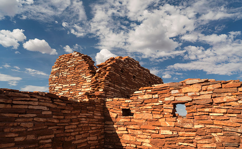
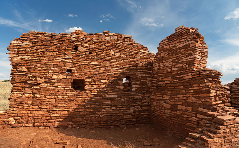
Victorious in my quest to capture the ancient whispers etched into stone, I returned to our trusty steed, the Turd. There, amidst the dust and echoes of bygone civilizations, sat Queen Anne; her latest book–escape, concluded. Her gaze met mine, an unspoken dialogue of adventure’s end, punctuated by a brief, ‘Can we go now?’ Her tone carried the weight of a royal decree, yet I knew the kingdom’s treasury of wonders still had one gem left to unveil.

At the end of the infamous paved road, you can turn south towards the abandoned town of Gold Butte or go straight towards the Arizona border and the Grand Canyon—Parashant National Monument. Both roads are equally evil to drive on, but I wanted to find another relic of history—a WPA-era dam, so I started east. We didn’t travel far because I spotted a cistern on the left as soon as we drove through the first dry wash. I pulled the truck over and grabbed my camera.

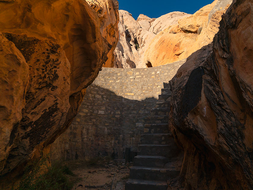
The cistern looked like a dry concrete bathtub, and a rusty pipe beckoned from the cistern to a narrow canyon on the right. A couple of creosote bushes blocked the view (and the path), so I brushed them back with my arm and saw the dam. It looked like a scale model of the Hoover Dam 50 miles downstream. Although it was built in the 30s and no longer maintained, it looked like it would still hold water if you closed the gate and valves. It is another testament to those folks’ work during the Great Depression.

After getting some shots, I wanted to see how deep the backside was, which meant climbing the stairs. In my younger days, I would have said, “Nothing to it,” and jogged up the stairs. But there’s no handrail, and my balance isn’t the same, so I did it the hard way—backing up one step at a time while sitting on my butt. I got my dose of vertigo and started back down the stairs when three outdoorsmen walked through the slot. My face turned red, and I apologized, “Sorry guys, this is how we geezers climb stairs these days.” One of them quipped, “We understand—Mister Girly-Boy.”

An erosion-formed window in a sandstone canyon wall, illuminated by sunlight at Gold Butte, photographed by Jim Witkowski.
Nature’s Art Frame: The Erosion Window of Gold Butte -Carved by the patient hands of time and elements, this erosion window in Gold Butte’s canyon wall frames a story millions of years in the making—each layer a verse in earth’s grand narrative.

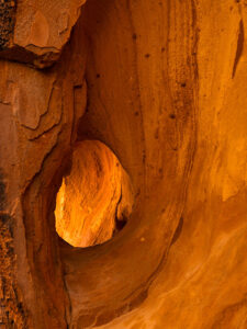
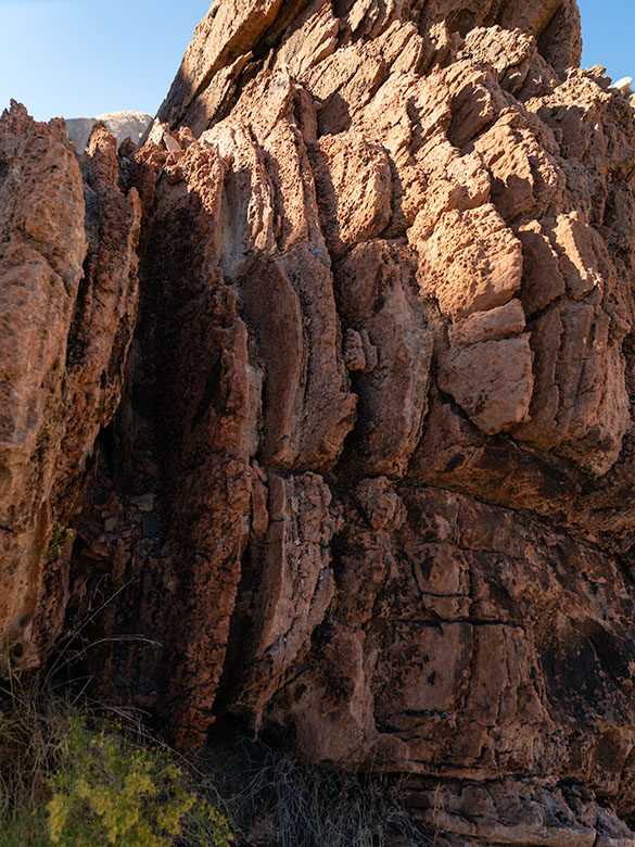
This week’s other photo is of a natural erosion window along the canyon’s narrow. Unless you’re the stature of our friend and frequent commenter, Deb Poteet, you can frame your face with it by standing on your toes. As usual, Anne wouldn’t get out of the car, so I had to settle for shooting the opening without her pretty face. Still, it’s pretty cool.

In the mirror

Queen Anne and I covered a lot of ground this year. We visited two California Wine regions without being tossed out on our ears. We followed some of our favorite trails and got reacquainted with the charming cities of Bisbee, Tombstone, and Douglas. We explored the Beeline Highway and the Mazatzal Mountains, shot wildflowers in the spring, got caught in a monsoon storm at sunset, and discovered some fantasy shapes in Prescott’s Granite Dells City Park. With pandemic restrictions lifted, we did a decent job of broadening our range and bringing you more diversity with this year’s photos and stories.

This has been a year of growing for us. I’ve tried to improve my writing skills. I completed a couple of online creative writing courses. You’d think it would make my work more manageable, but it didn’t. What I used to knock out on a Sunday morning now takes me three days of writing, editing, and revising before I’m ready to publish. I also invested in a grammar checker that—hopefully—gets most of the commas in the right places.

I’ve been tinkering with my photo processes by watching online photographers. I picked up some new tips and tricks, which I’ve tried to pass along to you in the Techniques section. I think you found them helpful because I’ve received positive feedback from you. Finally, to attract new subscribers, we started producing monthly YouTube videos. In each of the last few months, I converted one of my static portfolios into a five-ish-minute video with music and voice-overs. With these new videos, we’re blending the old-world charm of static images with the zippy excitement of moving pictures—without the smell of darkroom chemicals. It seems to be working because my web traffic is on the rise.

Through the windshield

I have an Arizona wall map on our laundry room wall with colored dots indicating the places we’ve visited in the last couple of years. Instead of being evenly distributed, two empty spots glare at me from the map. The first is along the southern border between Nogales and Yuma. Since that’s restricted chiefly to military ranges, there’s not a lot I can photograph without starring in my impromptu sequel to North by Northwest. The other section is the northeast corner of Arizona—the Navajo and Hopi reservations. I intend to paste a dot or two in that corner next year. Maybe you could suggest some locations.

There’s more to discover at Gold Butte National Monument. I plan to return this spring if the Turd’s crummy tires ever wear out. Getting stuck out there without communication is a genuine concern for us. Some sights we missed this year include Devil’s Throat, the remains of Gold Butte’s ghost town, and Little Finland.

Finally, next year’s wine region adventure will be in Northern California. Will it be Napa, Sonoma, or the Russian River? Let us know where your favorite California wine comes from. We haven’t picked a winner yet, but the trip will be in August. As Samuel Clements once said, “The coldest winter I ever spent was a summer in San Francisco.” Some dispute that the quote is genuine, but for us desert dwellers, it’s a challenge.

Queen Anne and I wish you a very happy and prosperous New Year. We hope you’ll continue joining us on our escapades and maybe invite some friends. We’re always delighted to see you in the back seat. Feel free to share your New Year’s adventure plans in the comments below. They give us ideas for which roads we take.

Till next time, keep your spirits high and your humor dry.
jw

BTW:

Last week, I released my latest YouTube video based on my portfolio of pictures of California. It’s five minutes of eye candy, and I invite you to see it by using this link: [https://youtu.be/cgXAHPyzQ5Y]

Geologic Puzzle: Unearthing Whitney Pocket’s Sandstone Secrets Picture of the Week - Mesquite, Nevada

Brown layered Navajo Sandstone uplifted and eroded by fault activity in Whitney Pocket, with unusual rounded edges and color variation.
Geologic Puzzle: Unearthing Whitney Pocket’s Sandstone Secrets – Nature’s Tilt: Witnessing the Story of Uplift and Erosion in Whitney Pocket’s Sandstone Layers.

Arriving at a new location like Gold Butte ignites a whirlwind of excitement in me, and my initial instinct is to capture everything in sight. This flurry of photography is more about immersion than precision, leading to a digital pile-up that I inevitably sift through, discarding the excess like chaff. Unlike the costly days of film, where each shot was a precious commodity, the digital age allows me to indulge in this initial creative outburst, knowing it’s part of reaching the true gems.

Once the initial rush subsides, I transition from capturing to contemplating, delving into the ‘why’ and ‘how’ of the landscape before me. It’s here that Shawn Willsey’s geology videos come into play. As a professor at the College of Southern Idaho, Shawn has a gift for demystifying the complexities of earth science, guiding even the uninitiated through geological wonders. His explanations, particularly his Random Roadcuts segments, clarify unusual layering and erosion and bring a new depth to my photographs, transforming them from mere images to stories set in stone.

From a distance, the formation in the picture above looked like the blades of a turbine engine embedded in the Navajo Sandstone. For all I know, there is a 747 out there with the guts missing from one of its engine cowlings. The brown color, multi-layers, with rounded edges, stood out like the red marks on one of my term papers. How can I tell you about it when I haven’t a clue? So, I emailed Professor Willsey and asked if he’d look at my photo—and he accepted. He answered, “The feature in question is not a vein but appears to be an upturned section of Aztec (Navajo) sandstone. The near vertical layering is the cross beds deposited on the dune field’s backside (downwind) side. Some faults and other structures in this region of NV are likely the culprits that have tilted the rock layers. Very cool.” Then, he returned to hosting his live coverage of this week’s Iceland eruptions. Now, don’t you feel smarter?

A butte in Whitney Pocket with layered Navajo and Entrada sandstone, with the red end facing south, creating a 'Neapolitan ice cream' effect in the desert.
Neapolitan Earth: Unraveling Whitney Pocket’s Colorful Geology – Stratified Delight: The Neapolitan Butte of Whitney Pocket, where Geology Meets Gastronomy.

There’s a question in this week’s other picture as well. It’s an image of a sandstone formation that looks like a bowl of Neapolitan ice cream after Queen Anne was done with it. I say that because Queen Anne always eats the chocolate and turns her nose up at the rest. The issue is that the red section appears on the white layer. From all I’ve read, the Entrada era—with its rust-colored sandstones—came before the white dunes. My best guess is that the forces that lifted the Virgin Mountain Range over a mile in the air also jumbled the natural order in this basin. What are your thoughts?

I have posted larger versions of Geologic Puzzle on my website < Jim’s Web> and my Fine Art America page <FAA Link> should you want to examine the layers closer. Next week, we wrap our foray into Gold Butte National Monument with one of the rare evidentiary remnants that anyone preceded us. It’s like unearthing the Spinx. Join us then, won’t you?

Until next time, keep your spirits high and your humor dry.
jw

BTW:

As we gather to celebrate the holiday season, Queen Anne and I would like to extend a hearty Seasons Greetings to all of you. Whether you’re out there chasing the perfect light or cozening up at home with loved ones, may your days be merry, bright, and filled with the joy of discovery. Here’s to capturing more beauty, sharing more stories, and creating unforgettable memories in the year ahead.

Eagle Crags Picture of the Week

Eagle Crags - Red-rock Vermilion Cliff outcrops covered in snow make a perfect Christmas greeting card.
Eagle Crags – Red-rock Vermilion Cliff outcrops covered in the snow make a perfect Christmas greeting card.

Have you ever been in a situation where you had to resort to Plan B at the last moment—and in the end, Plan B was always the better choice? In a convoluted way, that’s what I did to bring you this week’s picture. Let me start at the beginning.

When I set up my December project, I already had four photos picked out. Three of them went up without a hitch, and the last was scheduled for today. I thought it was a doozy—a view of looking down the stairwell of the Hassayampa Inn. You know, one of those shots where the stairs wrap around the frame and seem to go on forever. In the photography world, if you see a shot like that and don’t snap the photo, they will revoke your Artist License.

When I looked at the file closely this week, it was too blurry. The stairwell was dark, and I didn’t hold the camera steady enough while the shutter was open. If you saw it from across a large room, you couldn’t tell, but on close inspection, it looked like something my Aunt Kay would take. I gave up and deleted the file like the professors told me.

Now I panicked and started looking through my files for an alternative. This is where I got distracted and began chasing squirrels. My RAW image files are only halfway organized. I started a system a couple of years ago where I keep them grouped by State-Location-Year (I have so many Arizona pictures that I include a county folder, State-County-Location-Year). Since we moved to Congress, I’ve used this system, but my older files haven’t yet been sorted. It’s one of those Round-To-It things. You’ve probably guessed that I picked this week to start organizing and forgot that I was looking for this week’s post.

I was working on a 12-year-old file from a trip that my friend Jeff and I made to Zion National Park. We’d driven there on the long Thanksgiving weekend and shared a motel room. One image mixed in among the others was a shot of a Vermillion Cliffs uplift called Eagle Crags. When I looked at this image, I wondered, “Why haven’t I ever shown this file?” The mystery was solved when I looked at the file data. The camera that I used had a limited file size and couldn’t be used to make decent prints, so I considered it a snapshot of the weekend.

As I looked at the broken snow-covered sandstone, I remembered that Adobe had added a Photoshop tool that added pixels to an image from thin air—using artificial intelligence. So, I dug around and processed my small file using the “Super-Rez” tool, and the results were impressive. The original file would comfortably fit on a 5”x4” photo, but if you visit my store, you can see what it would look like 5 feet wide. It’s good enough to include on my Web Pages. So while I’m stuck in the house recovering from the crud Queen Anne passed to me, I can wade through more files and discover other hidden gems.

You can see a larger version of Eagle Crags on its Webpage by clicking here. I hope you agree that it’s a lovely Christmas card from Queen Anne and me. Next week we begin a New Year, a new month, and a new project. Be sure to come back then and see where the road takes us.

Till next time
Jw

BTW:

From the Witkowski household to you, we wish you a Merry Christmas and a prosperous New Year.

KofA Thunderhead Picture of the Week

KofA Thunderhead - An autumn thunderhead builds over the KofA Mountains in western Arizona.
KofA Thunderhead – An autumn thunderhead builds over the KofA Mountains in western Arizona.

Each time Queen Anne and I jump into the car; I pack a camera in the back seat. I don’t mean on local errands like a trip to the grocery store but on drives longer than an hour. Rarely do I stop to take a picture, but should one of those once-in-a-lifetime moments happens, I’m ready.

If I capture some unique photographs, they don’t fit our usual workflow. We usually pick a location as a month-long project and photograph enough shots for a month of articles (or even a book). My one-of-shots along the highway traditionally become forgotten orphans. No one gets to see them—until now.

For December, I decided to make this month’s project out of the non-project shots I collected this year. With these four pictures, a special moment made me pull over and stop the car. That’s pretty hard to do because once I have a destination set in my mind, I only stop for gas, a candy bar, and bladder relief.

Anne and I run to Mexico about four times a year. We go to Algodones to see our dentist and buy 90 days worth of prescriptions. We’re on Medicare, and we have a gap plan that pays for most of the pills we take, but some of the select drugs (hint: you see them advertised on TV) are so much cheaper in Mexico that it pays for the drive. If we don’t have to wait on the dentist, we can make a drug run in a day. We leave here at 8:00 am, walk two blocks across the border, stop at Mickey D’s for lunch, and get home by 5:00 pm.

That was our itinerary on September 22—the first fall day. As we drove home on Highway US 93, I watched a single thunderhead building thirty miles north over the KofA Mountains. I thought it unusual to have monsoon activity in autumn and a single storm cell develop so far west in Arizona. I spent the next half hour arguing with myself.

“That will be a great shot if the clouds hold together until we get there.”

“If we stop, we’ll get home after dark.”

“It’s an isolated cell, and it’s posing like a runway model.”

“It’s the wrong time of day, and the light is wrong.”

Just after passing the Border Patrol station that marks halfway between Yuma and Quartzsite, I noticed that the cloud was beginning to tear apart (the wispy part on the tower’s left side). It was time to stop the car. I reached back for my camera and hiked a few steps off the highway. I set the zoom-lens as wide as possible before framing and then snapping a couple of shots. I call this week’s featured image KofA Thunderhead.

The spot where I stopped was several miles away, and for perspective, the jagged KofA peaks rise a couple of thousand feet above the 500-foot high basin. That makes the billowing cumulus top nearly 40,000 feet in the air. Unfortunately, I didn’t capture any lightning strikes beneath the storm.

We returned to the road and continued the drive, watching the storm evolve. The upper winds blew the clouds apart by the time we were due east of it. That’s when we saw a funnel cloud drop below the ceiling. The tornado briefly touched the ground near Crystal Hill Road before it disappeared.

We weren’t done with it yet. After stopping for gas in Quartzsite, the storm ambushed us on the pass at Guadalupe Mountain. As it moved north over Interstate 10, it dumped rain so hard that the wipers couldn’t keep up, and traffic slowed to a crawl. We hoped we wouldn’t be surprised by a second tornado, but after a mile or so, we broke into the clear, and the deluge was only an image in the mirror.

You can see a larger version of KofA Thunderhead on its Webpage by clicking here. Next week, I’ll drag out another orphan photo for show and tell. We’ll see you then.

Till next time
jw

BTW:

Anne and I are negotiating next year’s schedule, so there will be a lot of yelling and screaming around here during the holidays. Pay no attention to the man behind the curtains.

Lomaki Crater Picture of the Week

Lomaki Crater - When viewed from the far side, Lomaki's tall walls appear like the craters that surround the national monument.
Lomaki Crater – When viewed from the far side, Lomaki’s tall walls appear like the craters surrounding the national monument.

How did your Turkey Day go? I can see your eyes struggling to read these words, so at least you’ve come out of the tryptophan coma and gotten off the couch. That’s good. At least you didn’t turn into that weird uncle that kids are complaining about these days—or did you?

Hassayampa Inn - The four story red-brick hotel was opened in 1927 and is one of the State's historic inns.
Hassayampa Inn – The four-story red-brick hotel was opened in 1927 and is one of the State’s historic inns.

Queen Anne and I skipped our usual Denney’s Thanksgiving Day dinner. Instead, we drove up to Prescott and spent the night at the Hassayampa Inn. Since I’m a history freak, we thought it would be cool to dine at the historic hotel and stay for the night. The red brick hotel is far more charming inside than its block exterior suggests. Art Deco, Spanish Revival, and Territorial styles are all mashed together. Except for the scruffy Romanian bartender, I don’t believe anyone on the staff is over 30. They were so bright-eyed, cheerful, and eager to help that it was depressing.

Dinner—well, lunch, really—was uninspired. The special was a half of a Cornish Game Hen oven-roasted turkey style on a plate with a round lump of stuffing, another lump of mashed potatoes, and green beans. My favorite part of Thanksgiving dinner is gravy. Everything else on the plate supports the gravy, so we had to ask for more on the side. For dessert, the chef managed to duplicate a childhood recipe. My first bite of his apple pie brought a flood of memories of eating a Hostess fruit pie at the Circle K. The biggest sin of dinner was the omission of cranberry sauce molded in the shape of a can. An order of Buffalo wings would have been more satisfying.

With that aside, we had a great time in Prescott. We drank wine beside the lobby fireplace, snuck into room 426—where Faith, the ghost lives, walked around the town square, and ended the night by closing a karaoke bar. It’s not what you think; we literally got the bar shut down. We were in the middle of our version of I Got You Babe, when the health inspector bust through the door. He was there because of multiple complaints of howling dogs as far as three miles away. “That singing is not fit for human consumption,” he yelled to the bouncer. Then he took our mikes and told us to return to the hotel and stay in our room. He then padlocked the place until they got more safety training. I was devastated because Anne does a great Sonny Bono when she gets near the right key.

Enough of that; let’s talk about what you came for; this week’s picture. I call the image Lomaki Crater; it’s the last in our series from Wupatki National Monument. I took it on the far side of the pueblo ruin photo from a couple of weeks ago. With a bit of imagination, the tall wall corner resembles a crater like the ones we shot on our visit. There’s even a puff of smoke coming out of the cauldron. The bare walls are a mix of local limestone and Coconino sandstone. When they were built around 1100, they were most likely covered with plaster like the ruins in Walnut Canyon.

You can see a larger version of Lomaki Crater on its Webpage by clicking here. Next week, we start our final project of the year, and even I don’t know what it will be. So, when you come back next week, we’ll both be surprised at what I come up with. I’ll see you then.

Till next time
Jw

BTW:

No dogs were hurt in the making of this article, just my feelings.

Ancient Door Picture of the Week

Ancient Door - A mysterious door between Lomaki rooms beckons you to see what's on the other side.
Ancient Door – A mysterious door between Lomaki rooms beckons you to see what’s on the other side.

When I photograph a place like Lomaki (the Hopi word meaning Beautiful House), I try to walk its perimeter, looking at how the light falls on it. Then I look at details that help fill in its story. As I move around, I’ll stop and take shots of things that intrigue me. My photos are more intuitive than systematic. I look for contrasts and shadow patterns that place the subject in a specific moment.

I was doing that when I entered the Lomaki ruin and came across the door in this week’s picture. I saw the door and thought, “This looks interesting.” I framed the shot and snapped the shutter. Typically, an image with a busy pattern in a uniform light doesn’t work because it looks like a Where’s-Waldo puzzle. However, the dagger of light on the room floor commands your eye to go through the opening. It’s a walk-towards-the-light moment.

As a younger man, I was six-foot tall, but gravity has taken its toll, and now my diminished stature is only 5 foot 11½ inches. Even in my current dwarf state, I had to do a full Asian bow to fit through the doorway. That means that the Pueblo people that built this structure were short. Otherwise, they would constantly bang their heads on the lentil when they came home Saturday nights drunk from the bar. Believe me, that gets old fast.

As I walked through the complex, I got to another room with a low window. Through it, I saw a creature with five legs. It gave me a fright. Was it a centaur with an extra appendage or a giant arachnid with three legs missing? On closer inspection, I saw three legs were carbon fiber, and the other pair wore shorts. The creature turned out to be a fellow photographer. She was a coed from ASU working on a YouTube video about Wupatki.

It’s funny how photographers behave when they bump into one another out in the field. After seeing another camera, they let down any guards. They stop being solitary wanderers and suddenly become highly social as they compare notes. “Did you see this?” You should go there.” In the age of digital photography, it’s gotten worse because now they can compare their shots on the back of their cameras and go into full chimpanzee mode, “Look at this one—ooh ooh ooh ah.”

After our pleasantry exchanges, we parted ways, and she returned to the parking lot. Of course, I didn’t ask for her name or YouTube channel. Queen Anne would kill me on the spot if she knew I talked to a college-aged woman in the field without her chaperoning. After I finished shooting, I hiked back to the parking lot, where Her Majesty was waiting in the car. If I was lucky, her nose was buried in her Kindle reader, and she didn’t notice anything. Before I could say a thing, she blurted out, “I asked that girl if I had to go rescue you.”

“What did she say?”

“She said you were happily wandering around snapping pictures, and you’d be there until you ran out of film.”

It was only then that I realized I was a bit hot, so I started the Jeep and guzzled some water in the cool air conditioning before driving back to Flagstaff. So far, there are no new YouTube Wupatki videos, but I’ll keep looking while I dream of mermaids.

You can see a larger version of Ancient Door on its Webpage by clicking here. Next week, I’ll show my last shot from Lomaki, so be sure to come back and see what we find.

Till next time
Jw

BTW:

It’s Thanksgiving week, so Queen Anne and I wish you a happy and safe turkey day.

Lomaki Picuter of the Week

Lomaki - The crooked walls look as if the fierce Northern Arizona winds will blow them over.
Lomaki – The crooked walls look like the fierce Northern Arizona winds will blow them over.

In the half-century that I’ve called Arizona home, I can’t count the times that I’ve traveled thru Flagstaff and then north on Highway U.S. 89. I travel that route to get to the Grand Canyon, Lee’s Ferry, Lake Powell, Monument Valley, Utah, or Colorado. My best guess would be once a year on average. Sometimes I even stop to take pictures along the way.

With that many trips, you’d think I’d pay no mind to the scenery, but that’s not true. There’s always something new. There’s one location that makes my jaw drop, no matter how many times I see it. I’m talking about the view at Sunset Crater Pass I wrote about last month. It’s an in-your-face example of something I learned in a college geography course: mountains affect climate.

The climate on the south side of the San Francisco Peaks is the polar opposite of that on the north. As you travel to Flagstaff from Phoenix, you climb into the pines, and the temperature can drop as much as 30° along the way. As fronts move north from the Gulf in the summer or west from the coast in winter, the mountains wring moisture from the air as it climbs the slopes. After passing over the mountains, the air is dry and picks up pressure on the way down. Dry air heats faster than humid air. The phenomenon creates a rain shadow on the mountain’s leeward side. The next time you travel north of Flagstaff, stop your car at the pass and take a look back—trees. Then turn to the north again—trees kept away.

Now that you know how mountains work, it’s easy to understand why the early Pueblo Tribes living at Wupatki lived in rock dwellings instead of log cabins. Amazingly, the Indians still used timbers to span the walls and hold up a roof. That means they had to drag lumber off the mountains by hand. They built their structures before the Spanish arrived, so they didn’t have horses.

This week we’re looking at one of the bigger pueblos in the National Monument—Lomaki. That’s a Hopi word that translates into English as “Beautiful House.” Anthropologists have partially restored its two-story walls. As you walk through the ruins, you begin to appreciate the ancient people’s masonry skills and tenacity. They must have had to rent scaffolding for walls that size at A-Z Rentals in town. It was either that or standing on one another’s shoulders. You’d do the same thing.

In this week’s picture, titled Lomaki, you get a good idea of the wall height. The windows are at eye level. A peculiar thing you notice in this shot is the walls are leaning. I’m not sure if the scientist put that feature in on purpose or if they weren’t as skilled as the original Pueblo builders. As a photographer, I have a thing about lines that aren’t level or square. Oceans don’t run downhill, so I wince whenever I see a seascape with a crooked horizon. On my first visit to Lomaki decades ago, its tilted walls jumped out at me. They look like a good wind will blow them over—and this area of Arizona is exceptionally windy. However, on this year’s visit, the walls were still standing and didn’t seem any worse, so maybe they’ll remain long after I’ve gone.

You can see a larger version of Lomaki on its Webpage by clicking here. Next week, we’ll walk around Lomaki and see its details. Come back then and see what we find.

Till next time
Jw

BTW:

The calendar cut-off day is Tuesday, so if you are interested, place your order.