Burro Creek Bridge Picture of the Week

I had been asleep for an hour when Queen Anne finally came to bed last night. She nudged me until I almost woke and snapped, “What?”

“It’s raining,” she gleefully said.

I rolled over, pulled the covers up, and tried to go back to sleep while grunting, “Harrumph.”

“It’s pouring,” she persisted.

“Why are you waking me?”

“You’re snoring,”

I was too sleepy to recall accurately what happened next, but I think she bumped her head because she went to bed and didn’t get up till morning. I swear that’s the actual conversation we had last night.

This year’s monsoon season is unlike the drought that we had last year. We’ve been enjoying a week of cloudy skies, isolated showers, and last night’s low was under 70°. It wasn’t that pleasant autumn-like 68° where you can throw open the doors and windows. It was 68° with 95% humidity—which is cool only if you have gobs of air blowing at you—aka swamp cooler. But still, we have a decent river flowing down the street out front and the Red Sea in our backyard. The two trellis vines out front that have spent last year imitating Paul Rubin’s death scene in Buffy the Vampire Slayer—are already sprouting fresh green shoots.

All in all, it’s been a good monsoon so far, and they say there’s more to come. I lament the wasted rainwater flowing down the streets. There should be a way to capture some of it and store it for a (forgive me) non-rainy day. The runoff flows down the washes and eventually into the Gila River, where the Gila Bend and Yuma farmers use it for their crops.

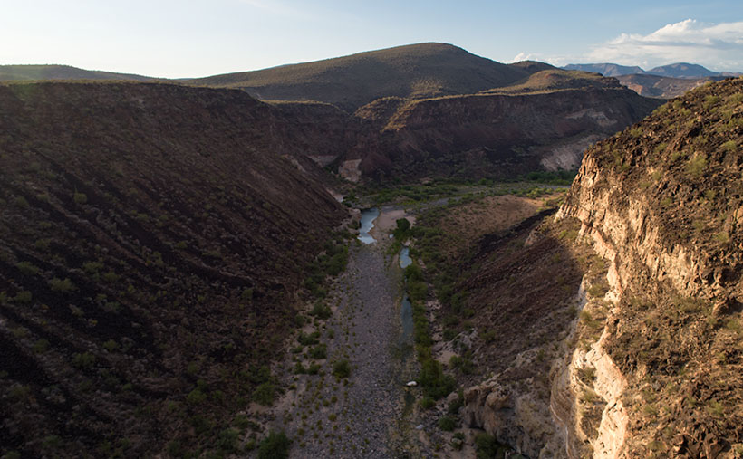
I’ll bet if I revisited Burro Creek—last week’s featured image—it would look like a proper creek instead of a string of puddles. I’m not going to risk a possibility of getting caught in a flash flood. Arizona has a Stupid Driver law now, and with my luck, I’d be the first person to get billed for my rescue. Instead—as I promised last week—I’ll turn the camera around so that you can see what’s downstream.

Burro Creek Bridges - A pair of future freeway bridges cross Burro Creek before Greenwood Peak.
Burro Creek Bridges – A pair of future freeway bridges cross Burro Creek before Greenwood Peak.

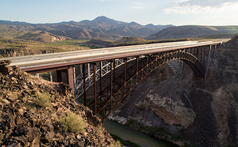
The subject of this week’s image is a pair of freeway bridges over Burro Creek, waiting for Interstate 11. Don’t be fooled into believing that this is an empty highway. U.S. 93 is normally a bustling traffic corridor. It’s just that my image was taken just after dinner when the freight drivers are still belching in truck stops.

You can see a couple of other things in the photo and another hidden by the bridge. First—under the bridge—are the deep pools in the creek. They’re wet all year round, so they have small fish in them. The minnows are useless to anglers, but they support a colony of Great Blue Herron that nest along the canyon walls.

Along the horizon is the 4,339 foot high Greenwood Peak. I have another shot of this mountain that was featured in a January 2020 post. During that month, Anne and I drove over the pass to the mountain’s left and, at the bottom, we found the road blocked by water flowing in the Big Sandy River. In that article, we remarked how the slopes of the Poachie Range were covered with saguaro and pinion pines growing next to one another.

Finally, what’s hidden behind the bridges is the Burro Creek Campground. It’s smallish with quiet camping spots until a loaded semi drives over the bridge’s expansion strips—the noise echoes along the canyon walls like Gilbert Godfrey with a megaphone. However, if you’re into history, the campground’s access road is the original two-lane highway that winds its way down the canyon, crosses the creek on a  low bridge, and then ascends the north face.

You can see a larger version of Burro Creek Bridge on its Web Page by clicking here. I have to come up with a creative idea for August, so please come back and see what I’ve come up with. For now, I’m going to don my galoshes and go stomp in some puddles.

Until next time — jw

Burro Creek Canyon Picture of the Week

There is the phrase Grand Canyon State on every Arizona license plate—it’s our state slogan. I find it ironic that the biggest thing we brag about is something that eroded millions of years ago. Sure, we have the World’s biggest hole in the ground, but there are many other sights in Arizona that we can be proud of.

I think that the slogan can have two meanings. First is obvious; the Grand Canyon State—we’re the state where the Grand Canyon is. The other interpretation that I see is; the grand canyon state—meaning that we’re a big state with lots of canyons within it. It’s true. We have pretty canyons all over the state. There’s the big ditch, of course, but there is also Canyon de Chelly, Salt River Canyon, Oak Creek, Madera Canyon, Sabino Canyon, and too many others to list here. Actually, I looked for a comprehensive list like the one I found for our mountains, but it alluded me.

Burro Creek Canyon - An awesome view that most people miss because they're in a hurry to get to Vegas, or back home.
Burro Creek Canyon – An awesome view that most people miss because they’re in a hurry to get to Vegas or back home.

Our stop this week along Highway US 93 is Burro Creek Canyon. The view of the canyon is spectacular, but it’s hard to see from the road. The bridges over the chasm are short, and the walls are high, so unless they’re in a semi-truck, most people don’t get to see over them—a gripe I share with the new bridge at Hoover Dam. The highway department didn’t build a scenic overlook, and you’re not supposed to walk across the bridge. You can take in the vista in my shot by parking in an unmarked lot accessible from the northbound lanes. Then, a short hike up a trail will get you to the south wall.

Canyons have always been important to Arizona travelers because you usually find water in them. After all, that’s how they were carved. Burro Creek is one of those exotic desert waterways that always has water (in normal years). As you can see in my shot, a couple of surface pools reflect the blue sky even during our extended drought. That makes the creek a reliable water source for wildlife, cattle, and even the wild burros that are pervasive in western Arizona.

I’ve considered adding canyons to my projects list. There’s enough subject matter to fill another of my book fantasies. However, my to-do list already has mountains, old towns, historic hotels, deserts, farms, Colorado Plateau, and the Grand Canyon on it. How do I prioritize them? Where would I ever find the time to photograph them all? I’d have to clone myself because my time is getting short, and the list keeps growing.

You can see a larger version of Burro Creek Canyon on its Web Page by clicking here. Next week, I’ll turn the camera around for a nice look in the other direction.

Until next time — jw

Foothill Uplift Picture of the Week

It’s already the last day of January. Where does the time go? After looking at this month’s photos, it seems that I spent a lot of my time around Aguila—with good reason. That’s the route that Queen Anne and I take when we travel west, so I knew there was stuff to shoot, and it’s close by—well if you consider an hour close.

Foothill Uplift - A pair of hills thrust into the air by plate tectonics.
Foothill Uplift – A pair of hills thrust into the air by plate tectonics.

This week’s featured image comes from the same area. I didn’t have to travel far after I captured last week’s picture—Harcuvar Forest. In fact, all that I needed to do was turn around. OK, let me explain. I wanted to shoot the saguaro forest ever since I first saw it on a trip to Robson’s Mining World, but it’s miles north of the highway and tucked under the cliffs of the  Harcuvar Mountains. My topo map shows a jeep road that runs behind a couple of hills situated between the highway and the forest. The hills screen the cactus patch from the highway. So, me and Archie did a little four-wheelin’.

After I had finished shooting the saguaros, I noticed that the north side of the hilltops behind me weren’t rounded as they appear on the south. Instead, they had a ridge of broken rocks—plate tectonics fractured them and pushed them towards the sky. Since I find edges like these interesting, I decided to waste some time photographing them.

This week’s featured image is the result of my curiosity. I call this photo Foothill Uplift. There are a couple of things that I like about this image. I like how the second hill repeats the pattern of the foreground one. It’s like they’re lined up for presentation. The same wedge shape shows up again on the photo’s right side. Along the horizon and on the far side of the Aguila Valley is our old friend Black Mesa. It’s the western high peak of the Vulture Mountain Range that stretches all of the ways back to Wickenburg. Finally, I love the double-headed saguaro, which I couldn’t see from the trail. It’s the garnish that completes the cocktail.

You can see a larger version of Foothill Uplift on its Web Page by clicking here. Be sure to come back next week, and I’ll see what I can scrounge up from around the neighborhood.

Until next time — jw

Warm Springs Cholla Picture of the Week

This morning, when I got out of bed and looked in the bathroom mirror to see if I still had a reflection, I scared myself. What little hair that I still have was standing perpendicular to my head. I think I stuck my finger in a light socket last night. I’m puzzled at how the remaining five hairs on the top of my head—which are invisible when I comb them—manage to stick straight up like a coastal lighthouse. A less intelligent Albert Einstein stared back at me. I need a haircut.

When I got out of the Army, I had thick wavy red hair, and I went to a salon every other week to get it styled. I was on the hunt for a mate back then, so I had to look my best. I patronized one of those places that charged more because they cut your hair with a razor. I paid $30 for a wash, cut and blow-dry. I spent too much time each day trying to get that Glen-Campbell-look that was popular then. Then came the 70’s, and we just let our hair grow long. When my hair curled over my ears like Bozo the Clown, it was time to go to Floyds.

I turned gray when I was in my thirties, and suddenly I was an old man. As my hairstyle paid fewer dividends, I gave up and started combing it straight back. I only got a haircut three or four times a year, whether I needed it or not. Now I visit the barber when we make a Mexican pill-run. It’s cheaper there, and—because I’m a senior—I get a discount. The tip is more than the cut, and I still get change. I don’t even care what it looks like as long as it’s shorter than when I walked in.

We’ve suspended our trips to Algodones during this pandemic, so I’m taking matters into my own hands. I ordered hair-clippers from Amazon. They were supposed to be here on Friday but didn’t arrive. I’ve worked up the nerve to let Queen Anne put it on the shortest setting and shave it all off. How bad could it be? Besides, that’s why I have hats.

The day that Queen Anne and I traveled down Old Route 66 was the exact opposite of a ‘bad hair day’ (see how I did that?). The trip produced more good images than I usually get, and with good reason. The Black Mountain Range is an exciting pile of rocks. I can see me spending more time exploring them—especially when one of you coughs-up the funds for my hover-bike.

Warm Springs Cholla - Cholla along the roadside provide a good foreground contrast for McHeffy Butte at sunset.
Warm Springs Cholla – Cholla along the roadside provides an excellent foreground contrast for McHeffy Butte at sunset.

This week’s featured image is called Warm Springs Cholla. As you can tell from the colors, I took it as the sun was setting. We were several miles south of Oatman, and I was studying a  peak—McHeffy Butte—as we drove along. Suddenly (ta-da), a patch of cholla popped up, making a perfect foreground. After I stopped the truck, I hiked a short distance uphill into the Warm Springs Wilderness and fired off a couple of shots. I think the resulting image makes a great wrap-up to our Route 66 trip.

You can see a larger version of Warm Springs Cholla on its Web Page by clicking here. I hope you enjoy it. Next week is June and another back road adventure. I hope you’ll come back and hear about our road trip.

Until next time — jw

Boundary Cone Picture of the Week

Traveling west from Oatman, on the old Route 66, it’s only a couple of miles before the Black Mountains fill the rearview mirror. The Mohave Valley sprawls beyond the truck hood, and the road descends the talus slope to the river. There aren’t any signs here, but the beautiful view takes in three states. Arizona stops at the river, of course, but beyond the blue water, California is on the truck’s south side while Nevada is to the right.

The highway passes a rounded cone that resembles the hat style worn by the Seven Dwarves. The road has a fork here, and if your destination is Bullhead City, then go straight. But, the left fork is our historic road, and it leads south to the freeway and railroad bridges at Topock Marsh. We’re not done with the mountains yet because—for most of the way— the Warm Springs Wilderness is outside of the driver’s side window.

The Black Mountains in Mohave Country always delight me. There’s a lot in them to photograph. I understand why chunks of them have been set aside as wilderness areas. I could spend years exploring and capturing their beauty on film. As an aging dotard, however, I need my truck to do that. I’m intrigued about the new riding drones that police departments are buying. They look like a motorcycle with four propellers strapped to the sides (like in this Dubai video). One of you needs to come up with the money to buy me one. With my luck, however, I’d fall off into one of the blades and become sliced salami. Besides, the government doesn’t allow drones in wilderness areas (national parks, wildlife preserves, or recreation areas). What’s that old saying? “I would have taken better care of myself if I knew that I was going to live this long.” Why did we ever laugh at Jack LaLanne?

Boundary Cone - On the right is Boundary Cone, the center of the Mohave Tribe's world, and a handy marker to keep you dry.
Boundary Cone – On the right is Boundary Cone, the center of the Mohave Tribe’s world, and a handy marker to keep you dry.

This week’s featured image was a call at the line—sorry for the sports metaphor. I had another picture picked out, and already published, but when I started researching the area, the image that I call Boundary Cone has a better story. The 4000’ peak sticks out like a sore thumb from anywhere in the valley. The Mohave Indians consider it sacred, and it is the center of their homeland. Imagine how upset they were when miners started digging at it.

Coincidently, if you could walk from Boundary Cone due west to the middle of the Colorado River, and then north for a couple of hundred yards, you would be standing—or swimming—in Arizona, California, and Nevada at the same time. Just like people do at Four Corners, and nobody would charge you (I sincerely think people would pay to see that). The actual point where the three states meet is the intersection of the 35th parallel and the Colorado River. But, I think it’s cool that you can tell which state you’re in by glancing at Boundary Cone without getting wet.

You can see a larger version of Boundary Cone on its Web Page by clicking here. I hope you enjoy it. Next week, we’ll continue our Route 66 journey to the freeway. I hope you’ll join us then.

Until next time — jw

Tom Reed Mine and Elephant’s Tooth Picture of the Week

After publishing last week’s post, I lingered in my office for a while with a nagging question. It was more of a puzzle than a burning issue, but it would persist until I solved it. My enigma was this: If Lt. Whipple completed his survey in 1854, and the railroads were already following his trail, why in 1926 did the Highway Department run Route 66 through a rugged mountain pass when they established the National Highway system? Wouldn’t it be faster and cheaper to follow the railroad tracks down to the Colorado River? I used up over half of my monthly Google query allotment trying to understand their logic. After distilling some facts that I uncovered, and with some fantasy time travel, I concluded that the department wanted travelers to go through the shining city on the hill—Oatman. When the mines were still open, Oatman was a bustling city, with a good hotel, restaurants, bars, groceries, and gas stations.

Oatman Main Street 2020 - The crowds of tourists are gone, the stores are shuttered, and even the burros are social distancing.
Oatman Main Street 2020 – The crowds of tourists are gone, the stores are shuttered, and even the donkeys are social distancing.

Arizona has two types of ghost towns, and to paraphrase a line from Frank Zappa’s song Camarillo Brillo, there are real ghost towns, and there are Walmart ghost towns. Real ones are scattered throughout Arizona’s mountains and plains. Places like Cochran, Cherry, and Ruby. If you drive there in your Jeep, you’d be lucky to find a standing building, but—most of the time—only their crumbling foundations remain. As for the latter towns, they’re thriving communities. Arizona’s big four include Jerome, Tombstone, Bisbee, and Oatman. People still live there, and more importantly, tourists visit by the busload. They come to drink in the saloons, eat lunch in the bordellos, watch the fake gunfights, ride oar carts into the mine shafts, and feed the wild donkeys. I wouldn’t be surprised to learn that these towns generate more annual revenue today than the mines ever did.

Before my first Oatman visit, I already knew the image that I wanted to take. Ansel Adams—the photographer that most inspired me—had already made it. Mr. Adams must have blackmailed God because he had Him move heaven and earth into compositions that no other mortal photographer ever saw. The photo that I’m referring to is in one of his books and is called Tom Reed Mine, near Oatman, Arizona. It shows a cluster of buildings on enormous washtubs with a pinnacle in the background. When I was younger, I tried to visit the places he captured so I could see what motivated him. That was my way of learning from a master. But in all my visits, I never found those impressive mine structures.

When Queen Anne and I made our Route 66 journey last month, snapping pictures in Oatman was the last thing I wanted. We were avoiding people, so stopping in a crowded tourist trap was out of the question. But when we arrived, the streets were empty of people wearing funny hats, loud shirts, sandals with black socks, and speaking in foreign tongues. The merchants had shuttered the windows, and even the wild burros—the stars of the Oatman experience—were social distancing. I had to stop and document this weird moment—Oatman had turned into a real ghost town.

Tom Reed Mine and Elephants Tooth - The concrete foundations are all that remain of the magnificent structures that Ansel Adams photographed.
Tom Reed Mine and Elephants Tooth – The concrete foundations are all that remain of the magnificent structures that Ansel Adams photographed.

As we drove out of town through the south side, the sun was low in the sky and casting lots of color on the hills—including the pinnacle that Adams captured. I stopped on the road where some concrete foundations lined up below the white outcrop—that I now know is called Elephant’s Tooth—and took this week’s featured image. I call it Tom Reed Mine and Elephant’s Tooth. We spent less than 15 minutes at that location before driving on.

Since we’ve been home, I was curious about the Adams photo, so I got it down from the bookcase and searched for his rendition. I wanted to see the buildings that he shot again. I’ve never been able to find them no matter how much I scoured the town. Upon examining his image, I realized that he took that photo in 1952, and people have since torn down the structures. The only trace of their existence is the concrete terraces in my picture. When I took my photo, I stood within ten feet of where Ansel Adams worked his magic, and we were both inspired by the same subject. I was so close to being in the presence of greatness—I only missed him by 68 years. My life can go on now.

You can see a larger version of Tom Reed Mine and Elephant’s Tooth on its Web Page by clicking here. I hope you enjoy it. Next week, we’ll pass by the Warm Springs Wilderness on our way to the Colorado River. I hope you’ll join us then.

Until next time — jw

White Bluff Picture of the Week

For most of the 1200 miles between Oklahoma City and Barstow, Route 66 and Interstate 40 are stuck together like a zipper. As you drive along the freeway—started in 1957 and completed in 1984—you can see a ghost of the old mother road on the roadside. Sometimes it’s a frontage road with little traffic, in different spots the pavement is gone, and it’s not a road at all.

Arizona has two exceptions to these overlying trails. The first is where Interstate 40 cuts off Peach Springs between Kingman and Seligman, and the second is between Kingman and Needles. In the first case, the freeway cuts miles off the trip by heading straight across country, while the latter deviation is further (albeit quicker) as it skirts the Black Mountain Range.

The section of the historic road that Queen Anne and I explored this month cuts through a mountain pass that Captain Lorenzo Sitgreaves mapped in 1851. Although the trail has beautiful scenery for me to photograph, it is very twisty and slow going, and that’s not ideal for interstate commerce.

Cool Springs Station - A historic gas station converted to a gift shop that now sells hot dogs from a cart.
Cool Springs Station – A historic gas station converted to a gift shop that now sells hot dogs from a cart.

After we finished photographing Thimble Mountain seen in last week’s post, we continued along the road for less than a mile, where we stopped at an old gas station called Cold Springs. The owners have converted it into a gift shop that sells nostalgic Route 66 kitsch, but there were no customers. As I snapped a few pictures, a woman’s voice came from the shadows, “Hello there. How ya doin’?” When I took off my sunglasses, I saw a young woman sitting in the shade next to a hot dog cart. We made small talk, and I asked about her business. “April is normally our best month, but this year it’s a bust.” After promising not to include her in my photos, I took another shot or two before we drove away. Looking back, we should have bought our dinner there. She could have used the money, and her food was probably better than the drive-through meal we got at the Kingman Carl’s Jr.

As we drove further, we had to stop almost immediately again, where the canyon narrowed. On the road’s north side was a pair of sandstone bluffs rising from the dry creek bed. Their cliffs glowed in the late afternoon sun, so of course, I had to capture the moment on film … er, I mean electrons. I’ve since found out that at this location, the road passes between two wilderness areas. To the north is the Mt. Nutt Wilderness, while on the road’s south side is the Warm Springs Wilderness area.

White Bluff - The vertical sandstone cliff of a bluff provide a great home to nesting swallows.
White Bluff – The vertical sandstone cliff of a bluff provides a great home to nesting swallows.

In this week’s featured image—called White Bluff—you can see Mt. Nutt in the distance. At over 5100 feet it is the tallest peak in the Black Mountain Range. To get any closer, you’ll have to hike or grab one of the local wild burros—of which there are many—and ride.

You can see a larger version of White Bluff Butte on its Web Page by clicking here. I hope you enjoy it. Next week, we’ll travel over the pass and make a stop in Oatman. I hope you’ll join us then.

Until next time — jw