Shiprock Picture of the Week

Wickenburg’s traffic has worsened over the past couple of months—especially during the weekends. People might feel more comfortable traveling now that Covid restrictions are easing, or maybe folks are just sick of staying home. In either case, going to one of the town’s grocery stores becomes annoying.

There used to be three US highways that ran through our downtown—US 60, US 89, and US 93. That all changed when the feds built the interstates (yes, children, back in my day, there were no freeways). Today, only US 93 remains a significant commerce route—lots of big trucks still pass through town. It starts downtown at the intersection of US 60 and Tegner Street and ends in Jasper, Alberta (the Canadian part isn’t part of the US highway system, but they used the same number on their side of the border).

I have a lot of mixed feelings about US 93. It’s the main link between Phoenix and Las Vegas. It was a narrow two-lane road with twists and turns that made you slow down. There are little white crosses littering the roadside. So many that it was designated the country’s most dangerous road. So, the highway department began inserting four-lane sections over thirty years ago. Even then, they knew it would become a freeway someday (sometime this century, they promise).

When I thought I had extra money to burn, I looked forward to the five-hour trip to Vegas or Bullhead City for an evening in the casinos. Other times, I’d drag my fishing rod to Black Canyon or Lake Meade with dreams of bringing home a whopper. Then, when my folks retired, they’d pull their trailer across the country, alternating between Atlanta—where my sister lives—and Kingman (it was far too hot in Phoenix). As they aged and became unwell, driving north on US 93 became less fun. I can’t begin to count the times that Queen Anne and I made that drive.

One of the landmarks along the road that I always looked forward to was along the Joshua Tree Parkway as the highway descends to the bridge crossing the Santa Maria River. Some large sandstone formations are hidden behind small hills just south of the bridge, and there’s a small gap where you can glimpse Shiprock. For decades, I planned a photography trip out there. The light was never right the couple of times that I tried.

Shiprock - Not the famous one on the Navajo Reservation that is spelled Ship Rock, but the lesser known one in our back yard.
Shiprock – Not the famous one on the Navajo Reservation that is spelled Ship Rock, but the lesser-known one right in our backyard.

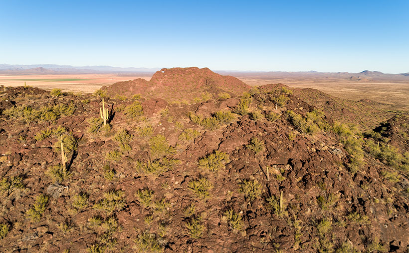
The formations are at the eastern toe of the Black Mountains (yet another range with the same name—these are in Yavapai County) and on the other side of Black Canyon Wash, away from the highway. They’re too distant to get a good shot from the road. I found a Jeep trail that got me over the hill, but I needed something like Fred’s Toyota to go down the other side. However, our friends ran out on us for the summer before I could bum a ride.

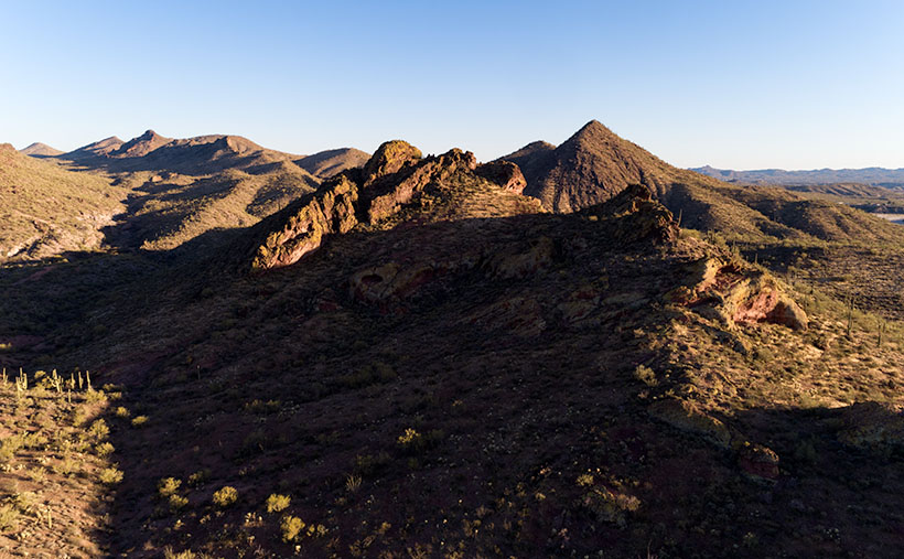
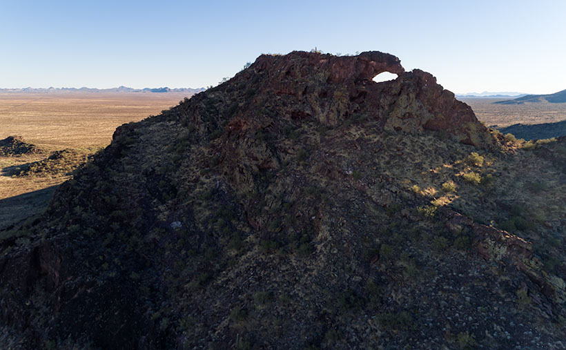
I took this week’s featured image from the hilltop, and I think it gives a pretty good long view of the sandstone formation and the Black Mountains. You can tell that it’s spring because green chaparral and trees fill the wash. Shiprock is the middle formation (the shadows conveniently point at it). Its name comes from how the left side resembles the stern of an old pirate ship.

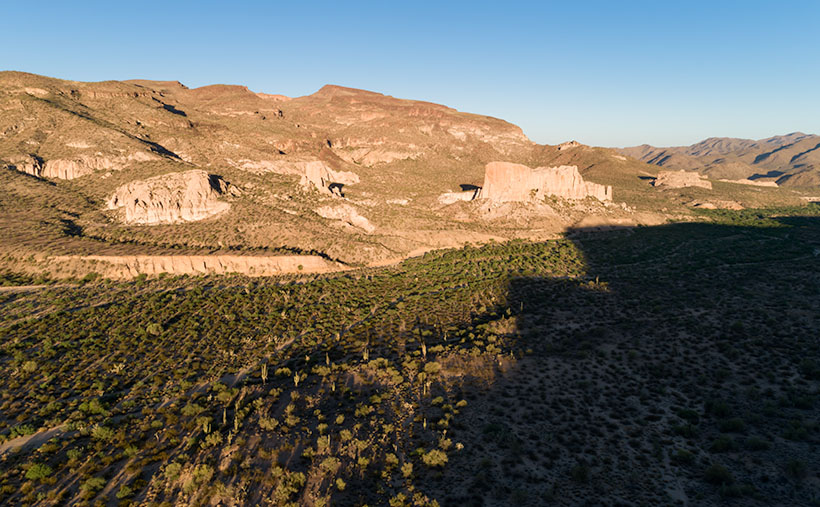
This photo also shows the Black Canyon Wash as it flows to the Santa Maria River, just beyond the photo’s right side. That river then flows between the Arrastra Range in the background and the Black Mountains to Alamo Lake. Everything in this picture behind the formations is part of the Arrastra Wilderness Area, so if you want to explore, you’ll do it on foot.

You can see a larger version of Shiprock on its Web Page by clicking here. Come back next week for another shot from around my neighborhood.

Until next time — jw

Skull Rock Picture of the Week

It’s the beginning of May, and right on cue, we reached temperatures in the triple digits. The heat immediately sparked an exodus of winter visitors out of our park. Even some of our full-time residents have already left for summer retreats. Queen Anne and I have been abandoned by our friends to deal alone with the pair of terrorists nesting in the trellis outside our bedroom window.

Since we moved into our Congress home, we’ve had all kinds of birds nest in our vines outside. We’ve had quail, dove, hummingbirds, verdin, and the usual assortment of sparrows—the low-life of the bird world. They’ve always been quiet and discrete and never called attention to themselves. This pair is an alumnus of the Delta Tau Chi.

In spring, we love sleeping with open windows. The fragrant fresh breezes keep the house cool, and there’s the occasional coyote howl, hooting owl, or the sound of a nighthawk we enjoy. As the sun begins to show light in the eastern sky each morning—the mornings are getting pretty early these days—Frank and Margaret celebrate surviving another night by perching on the trellis top and begin a sparrow’s equivalent of “Ode to Joy.”

Have you ever really listened to a sparrow’s song? It’s a flat, monotonous “chirp – chirp – chirp.” If left unattended, it can go on for hours. The Queen—who has disdain for anyone having pleasure—soon yells, “Off with their heads.” My obedience is blind, so I stumble out of bed, walk over to the window, throw back the sash, and scare the birds away with my ugly pre-coffee face. That chases them off, but it’s only a while before they’re back and at it again. Sing – scare – repeat.

When the sun does come up, their second act begins. With the new light, they see their reflections in the glass, and like the emu commercial on TV, they start defending their nest. They fly against the window, pecking at the reflection. They fly back and forth along the window top, fighting their perceived intruder. It’s a wonder that my window isn’t perforated. It doesn’t stop until I get up, walk over, pull down the blind, and show my face.

It’s gone too far, so I concocted an evil plan to get even. I went to Goodwill today and purchased an old-timey alarm clock—a bright yellow one. You know—the kind with two bells on top that dances around the end table until you smash it with a hammer. I set the timer for 2 am and hid it in the vines near their nest. I can’t wait for tomorrow when Frank makes a sparrow’s impression of Don Knotts. Meanwhile, I found an old English recipe for Sparrow Soup if it doesn’t work.

Skull Rock - People in Yavapai County love to paint rocks resembling objects to make it more obvious to other people.
Skull Rock – People in Yavapai County love to paint rocks resembling objects to make them more evident to other people.

This week’s featured image is called Skull Rock. The people in Yavapai County have a thing about painting rocks that resemble things because people would never figure it out on their own. Unlike our frog, you have to search for the skull. It’s halfway up the Hillside dirt road. It’s hidden behind the elevated railroad tracks, so you have to do a bit of climbing to get a shot of it. One story I read said a Santa Fe engineer originally painted it to tell passengers that the Apaches killed a poacher and left his skull behind to warn others. Then he’d laugh when they reacted as the train rounded the bend and the rock came into view. I can’t vouch for the story’s validity, but it sounds reasonable. You can see a larger version on its Web Page by clicking here.

Until next time — jw

Morro Bay Harbor Picture of the Week

The grass is always greener. People who live by the beach travel to the mountains for skiing. Others living in snowy climates come to the deserts to dry out and get warm. What do we desert dwellers do for a change of pace? We go to the beach of course.

After being cooped up in Arizona for the last year, when Queen Anne and I finally got our vaccine shots, we headed off to the left coast for a couple of days. It’s the anti-desert if you will. We drove an extra distance to our favorite part of California because we don’t care much for the giant megalopolis of San Die-Angeles-Barbara. There are too many people there, and they’re all out driving on the freeways.

We drove to what we call—the central coast—the Morro Bay area, and the little hamlet of Cambria. I love the place so much that two out of my three wives spent their first honeymoon there—and the third would’ve preferred it over Utah.

We spent three nights sleeping to the sound of crashing waves on the beach while a fireplace warmed the room. During the days, we put our masks on and enjoyed meals at our favorite diners and discovered new cafes (did you know that there are only four restaurants in the US with a Michelin star?). We strolled along the beach until my calves hurt, drove up to the Big Sur landslide, and peered into the windows of boutiques and galleries. Most importantly—we tasted wines at open vineyards—something we haven’t done since our 2016 Alaska trip. Let me tell you, our local Safeway gets really testy when we set up tables and start uncorking wine bottles for sampling.

But I also needed to photograph something fresh. Last month, I looked at the thumbnails on my New Work index page and realized that everything was brown. No matter how green the saguaros are, the Desert Mountains are brown. Aargh, I’m drowning in the dust. I need water. While Anne was snoring, I snuck out of the room to capture the sunrise, or after dinner, I’d plant her on a bench (she can’t walk when she’s full, so there isn’t much chance that she’d run off) while I walked around the harbor and snapped pictures as I did for this week’s featured image.

I consider Morro Bay’s town to be the southern edge of the famous drive through Big Sur. The Pacific Coast Highway (California 1) returns to the sea here and then continues up through the world’s best coastal scenery section. Here the Santa Lucia Range plunges 2,000 feet into the Pacific Ocean. The highway is temporary here because rock-slides frequently rip the road away from its precarious perch, like this year.

Morro Rock is the stump of a grand old Santa Lucia mountain that time and the sea have worn away. The rock and four neighboring smokestacks are a landmark that you can see from the mountain passes miles away. Morro Bay’s town used to be renowned for the abalone, but that delicacy has been fished out and is now protected. The commercial fishermen have moved on, so mostly private yachts are moored in the town’s harbor.

Morro Bay Harbor - private sail boats and cruisers during a calm spring sunset in Morro Bay, California.
Morro Bay Harbor – private sailboats and cruisers during a calm spring sunset in Morro Bay, California.

In this week’s featured image—Morro Bay Harbor—I tried to capture part of the local fleet using the big rock as an anchor. The setting sun made the cool, moist air glow gold. There’s an unexpected extra between the two boat groupings. In the water near the far shore is a sea otter floating on its back. Only his feet and head sticking above the water. You’ll never see it in these photos or on the Web Site. He’s there, at least I think he’s there . . . well I’m saying he’s there, and you’ll have to take my word for it.

I hope you enjoy April’s change of scenery. You can see a larger version of this week’s picture on its Web Page by clicking here, but if you want to find Waldo—the sea otter—you’ll have to buy an enlargement. Be sure to come back next week for another shot from the Big Sur coast and more fish tales.

Until next time — jw

Black Hills Picture of the Week

Queen Anne and I spent a couple of days last week visiting our favorite foreign city. That’s right; we went to Algodones, Baja California. I had to see my dentist and have a couple of holes in my head filled. Instead, she worked on my teeth.

Algodones (it means cotton in English) is famous for liquor stores, pharmacies, and dentists. The little town has over 350 dental offices within a 10-minute walk from the crossing. It’s straightforward for visiting Snow-Birds to park in the lot, walk across, hit the liquor store for liquid courage, get a tooth fixed, and buy pain relief on the way out.

During the pandemic, the Mexican border is closed, but there are exceptions for medical, educational, and commerce visits. The big restriction placed for Algodones was closing the crossing at 2:00 pm instead of 10:00 pm. Early on, many people didn’t know that, so the wait times at the customs house were nil. Well, the secret’s out. The line of people going through customs was over a mile long. There’s a break in the gate where our dentist is, and when we can join the crowd there, it’s a half-hour wait. On Tuesday, the end of the line was three times that distance. It was 12:40 pm when we started. At 2:00, when the siren blew, we were only half-way to where our usual starting place.

The way customs close the border is interesting. If you’re in a car, you’re out of luck. You have to drive an hour to San Luis or Mexicali, where the crossings are open 24 hours. But if you’re a pedestrian in line, they stay open until the end of the line. That’s good because I thought we were going to sleep in a cardboard box like homeless people. It was 3:30 by the time we stopped at the Yuma Carl’s Jr. for lunch/dinner.

There was something weird on this trip that has never happened to us before. When we made it to the line’s the halfway point, an American guy jumps out of his car—taps on my shoulder—and asks if we want a ride in his car. “You’ll be in line for another couple of hours, but the cars are crossing in a half-hour.” His car had four people in it already. Anne and I glanced at each other and declined. I’m of the generation that said, “Gas, grass, or ass. Nobody rides for free.” What if we got in the car and he demanded cash that we didn’t have. We’d be back on the street and at the back of the line again. Everyone around us also turned him down. What would you do?

Get to the Picture
Black Hills - As the Hassayampa River flows down from the Bradshaw Mountains, it cut a gorge through the Black Hills, known as the Hassaympa Box Canyon.
Black Hills – As the Hassayampa River flows down from the Bradshaw Mountains, it cut a gorge through the Black Hills, known as the Hassayampa Box Canyon.

Speaking of this week’s picture . . . (I know it’s a lame segue, so I won’t charge you for this issue.) This is another view of the Mountains/Hills that we’ve been photographing in March. I found that they’re called the Black Hills because of the dark crust along their tops, hence the photo’s title. This version was taken on their other side, looking back to Wickenburg.

If you own one of my 2021 calendars, these rocks are the same subject as the March photo. This time I wanted to get a closer look at the interesting fault thrust in the foreground, but when I processed it, I realized I had captured more.

You can see the Hassayampa River as it flows down from the Bradshaw Mountains on the mountain’s left side. But here, it turns right—behind the foreground rocks—and it cut a gorge through these hills. It’s a local attraction called the Hassayampa Box Canyon. Unfortunately, it’s hidden in this shot, but there is a glimpse of the river after it hits the Hassayampa Plain on the right side. Here it turns into a wide, sandy, and the water flows beneath the sand. That’s why the native tribes call it Hassayampa—upside-down river.

I hope my photo brings completeness into your life. You can see a larger version on its Web Page by clicking here. I like reading your comments, so feel free to add your two cents below. Be sure to come back next week for another image from the Wickenburg area.

Until next time — jw

Blue Tank Saguaro Picture of the Week

It’s only the third month of 2021, and already I can tell it’s a much better year than the last one. If you remember, this time a year ago, I was comforting my dear wife, who was convalescing from knee surgery, we had growing concerns about a new virus that threatened our existence, and we faced travel restrictions to slow its spread. In contrast, this week, I feel like a kid at the end of a time-out, no longer grounded or released from juvy (of course, I was such an exemplary child that I never experienced any of those feelings—my parents just spanked us).

I have this exhilaration of freedom because we got our second vaccination shot this week—and we have passports to prove it. If you’re debating on getting your shots, you shouldn’t be. Queen Anne and I didn’t experience any abnormal side effects. Like any flu shot, your arm is sore for a couple of days, but other than that, our lives went on normally. And as an extra benefit—like a putty knife—the Microsoft chip they snuck into the vaccine scrapes off any plaque in your arteries (but I do have an incredible desire to buy a new version of Windows).

We’re still cautious about our movements—we wear masks and keep our distance, but now we can plan to go on vacation later this summer. In our laundry room, I have a huge wall map of the Colorado Plateau. Whenever Anne gets out of bed this afternoon, I’m going to have her toss a spit-ball at it. Wherever it lands is the place we’ll drag our trailer—The Ritz—this August.

Blue Tank Saguaro - A mature saguaro growing along the bank of the Blue Tank Wash near Wickenburg, Arizona.
Blue Tank Saguaro – A mature saguaro growing along the Blue Tank Wash bank near Wickenburg, Arizona.

I’m so giddy this morning; I almost forgot this week’s new picture. If it looks familiar, it should. That’s because it’s a variation of last week’s featured image. They both show the mountains on the Hassayampa River’s far side, and they both feature saguaro cactus. The difference is that last week’s photo was of the mountains with cactus in the foreground, and this one is a saguaro with the mountains in the background. Who said you couldn’t get two good variations of the same scene by working-the-shot? I called this shot Blue Tank Saguaro for obvious reasons.

I’m interested in hearing what you think. Both images can be seen on their Web Pages, and you can flip between them using the Previous/Next links. You can get to this week’s image by clicking here. Which of the two do you like better? Let me know by leaving your comment at the bottom of this page. Be sure to come back next week for another of my images from the mountains surrounding Wickenburg.

Until next time — jw

UPDATE 4:30 pm: Anne got up and threw her spit-ball at the map, so I guess in August we’re going to . . . the laundry room.

Eagle Eye East Picture of the Week

My sweetie loves me! Incredible, I know. After living together for over 32 years, this morning, on Valentine’s Day, she asked me what I would like for a romantic dinner. The question took me by surprise. I had to think about it. I puzzled about which meals nurtured the minds and souls of great artists. What’s the most romantic place I can think of? Then it hit me—Giverny, France of course—home of Claude Monet. So I looked up the restaurant menu from Hotel Baudy—a scene in several of his paintings and where he gathered with many of his Impressionist cronies.

I Google translated each menu item looking for something manly and not cheesy. Halfway down the list, the obvious choice jumped off the page. It has three of the world’s best things you can put in your mouth in one dish: Magret de canard poêlé aux cerises et sauce au porto—seared duck breast in a cherry-port sauce. Ah—I slobbered all over my keyboard, thinking about it.

I rushed into the living room where Queen Anne was reading the Sunday paper dressed in her threadbare robe, fuzzy slippers, and rollers. I blurted out my dinner choice. I guessed wrong. She explained that what she meant was, “Which of the packages in the freezer do you want me to microwave for you—and you can’t have the one that I picked.” <Sigh> So, I picked the other TV dinner. Ain’t love grand?

Eagle Eye East - The view from the top of Eagle Eye Mountain looking east towards the arch on Eagle Eye Peak in Aguila, Arizona.
Eagle Eye East – The view from the top of Eagle Eye Mountain looking east towards the arch on Eagle Eye Peak in Aguila, Arizona.

Letting my romance wilt on the vine, let’s talk about this week’s featured image. As I promised last week, I wanted to show you the Eagle Eye Arch from another angle. In this image—that I call Eagle Eye East—we’re looking at the arch from the south side of the mountains in Aguila. I shot this picture from the top of Eagle Eye Mountain facing Eagle Eye Peak, and that’s why the arch seems more distant than last week’s photo. Since this was the sunny side of the mountains, it better shows how rough the lava surface is. I like how the bright green saguaro and palo verde contrast with the reddish-brown rocks.

Another interesting thing in this image—to me—is the background mountains. The Forepaugh Range is on the right and beyond them is the town of Wickenburg. Beyond the Aguila Valley, the tall mountains on the left horizon are the Weavers, and that’s where we call home.

You can see a larger version of Eagle Eye East on its Web Page by clicking here. Be sure to come back next week, and I’ll show you the final shot that I liked from my outing in Aguila.

Until next time — jw

Eagle Eye Peak Picture of the Week

The last time I wrote about Aquila’s Eagle Eye was in 2018, and I didn’t have much to say about it—other than it was there. That post included a photo I shot with a telephoto lens from miles away. I had to do that because much of the land around the peak is posted as private. There were two comments in that column. The first was from Fred, who thanked me for pointing the bridge to him, and the second was from my old friend Gary, who chastised me for not getting closer.

Since I’ve been hanging around Aguila this month anyway, I thought I’d try to make Gary happy. About three miles south of Aguila are mountains on the east flank of the Harquahala range. They almost have the same name; Eagle Eye Mountain is on the west, while Eagle Eye Peak is the lump of lava to the east (they touch one another). The latter peak is the one with the window on top.

Eagle Eye Peak - A natural arch on top of a peak several miles south of Aguila, Arizona
Eagle Eye Peak – A natural arch on top of a peak several miles south of Aguila, Arizona. Behind Eagle Eye is the Harquahala Plain, which stretches south to the Big Horn Range on the horizon.

You can get very close to the arch if you drive to the old cemetery where Eagle Eye Road bends around the mountains. The bad news is that you can’t see the arch from there because it faces east, and all you see are the rocks from the edge. There’s a better view if you scramble up an 800′ cactus-infested lava hill like an insane person, but I did the lazy thing. I brought my drone, and I flew it to the mountaintop. Once it got up there, I rotated it to the right and composed this shot.

The Eagle Eyes, like a lot of low desert mountains, were formed from volcanic activity. This particular pair of mountains is basalt-covered limestone. The rocks are much darker than the rest of the Harquahala Range. They appear as shadows on the horizon. Their surface is rough and pockmarked, like they had a bad case of acne. They are riddled with caves formed by air pockets in the lava.

I didn’t find an article that explains how this arch was formed. I don’t think it was formed from wind erosion. The rocks aren’t polished. It could be from one of those air voids in the thin-walled lava collapsing. My favorite guess is this: If this is Rhyolite—slow-moving lava common to peak formation—then maybe a cone of lava formed vertically, and as it cooled, it slumped over and froze in place. At least, that’s what it looks like to me. What do you think?

Well, Gary, I hope you’re happy. Click here to see a larger version of Eagle Eye Peak on its Web Page. Be sure to return next week when I’ll show you the arch from a different perspective.

Until next time — jw