Big Wet Sandy Picture of the Week

“I know a shortcut.”

How many of you have heard those words and broken into a cold sweat? The road that Queen Anne and I decided to explore this month didn’t start as a shortcut. It was supposed to be a much longer trip, but it got cut short.

I had intended to drive to the north shore of Alamo Lake. There are a couple of exciting mountains I’ve seen from across the water when I last visited. The best road to get there starts in Wikieup. On my maps (including Google), there are two ways to get there. One is twenty miles south of Wikieup, and the other is about five miles south. Both roads go to the little town of Signal. I’m sure you spotted the signs on a drive to Las Vegas.

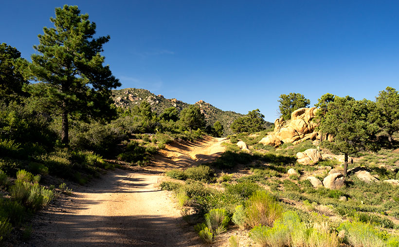
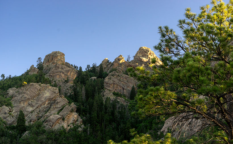
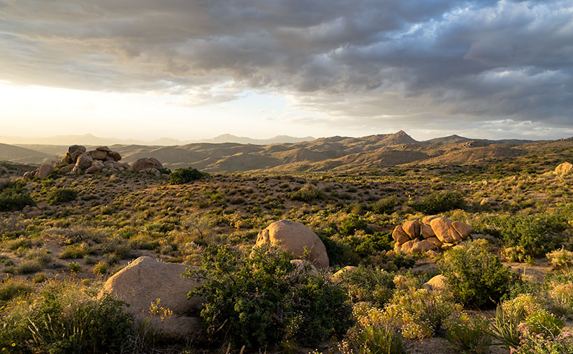
We decide to take 17 Mile Drive road. It’s the first left after the Nothing Gas Station. It’s a wide well-graded dirt road that climbs over a pass in the Poachie Mountains, then down into a valley where Signal is. The scenery at the pass is amazing—something we’ll get to later—and you can drive the route with your family station wagon. There’s one hitch along the way, and that’s crossing the Big Sandy River at Greenwood. Usually, crossing the river here could be tricky because—well, it’s deep sand, and you might get stuck without four-wheel drive.

Big Wet Sandy - The normally dry Big Sandy River flowing with water from recent rain.
Big Wet Sandy – The normally dry Big Sandy River was flowing with water from recent rain.

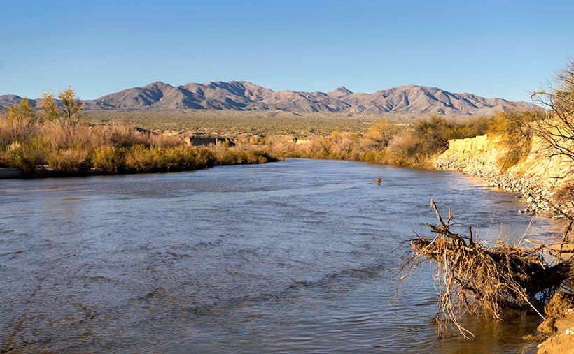
That wasn’t the case today. The Big Sandy was a real river and not in an ugly flash flood kind of way. Its waters flowed like it was an old river; clear and quiet. If I didn’t know better, I might have been tempted to pull out my waders and fly rod and make a few casts. It wouldn’t have been my worst day fishing, being the great angler that I am. There was no way to tell how deep the water was. It could have been two feet or a dozen, but it was not tempting enough for the police to cite me under the Stupid Motorist Law.

So, we’ll begin this month’s journey at the end and go backward. As I said, there was enough material to shoot in the mountains to fill a month, so we’ll save Alamo for another month, and we’ll start at the water’s edge.

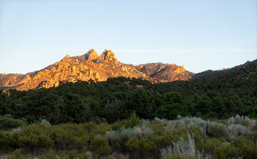
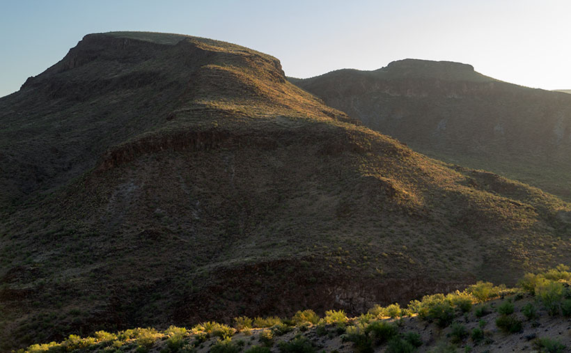
I took this week’s featured image standing on the river’s bank. If I didn’t know, I would venture a guess that it was a photo of the Colorado River south of Bullhead City, and the mountains were in Nevada. Nope, it’s all Arizona. We’re looking north-east, and the peaks are actually on our side of the Big Sandy. The high point is Burro Peak. Although everything appears calm on this warm winter afternoon, the banks on each side of the water show erosion from raging water at some time. There are more cliff-banks like this—some higher—along the riverside past Wikieup that you can see from Highway 93. I wonder if I’ll ever again see a sight like this.

You can see a larger version of Big Wet Sandy on its Web Page by clicking here. I hope you enjoy viewing it. Join us next week as we start our return over the Poachie Mountains.

Until next time — jw

Hualapai Road Picture of the Week

To reiterate what I said in my first post on exploring the Hualapai Mountains, there isn’t much open space there. The little village consists of a cluster of homes, a general store, and the county park for everyone else. There aren’t the amenities that you expect in Flagstaff or the White Mountain communities, but if you like camping and a challenging day hike, the park at the top of Sawmill Canyon Road is a different destination.

Hualapai Road
Hualapai Road-A dirt trail on top of the Hualapai Mountains that reminded me of the Loan Ranger’s opening scenes.

When I first arrived, I explored every road to see what’s there, but the only trail leading out of town soon became to rough and exceeded my road rules, so I turned around and headed back to the park. Before I did, I liked the rustic feeling of the country road, so I composed this week’s featured photo of the scene. I call this image Hualapai Road, although it’s little more than a trail.

The reason that I selected this photo over some others was how the trail curves over a hill between the rocks and trees. It makes me wonder where it leads, and what will I see when I get there. The countryside also reminds me of the opening scene of the old TV show The Lone Ranger that I used to watch as a kid on Saturday mornings. It’s easy for me to imagine the masked hero galloping on his white stallion over the hill—kind of like me and Archie.

You can see a larger version Hualapai Road on its Web Page by clicking here. Be sure to come back next week when we start another series of image from another location.

Until next time — jw

Potato Patch Picture of the Week

A couple of weeks ago, I talked about my struggle to climb a half-mile to an overlook on Hualapai Mountain Park’s Potato Patch Trail. Remember? Some hikers felt sorry for me and offered water while others were impressed that I was old, but still on my feet. Anyway, I’ll bet you’re wondering if there’s a picture from there. The answer is yes, and here it is.

Potato Patch
What appears to be the mountain top conceals the real summit – Hayden Peak which is another half mile away and three-hundred feet higher than these rocks.

This week’s shot is from the rocky perch looking up at a false peak. It’s one of those illusions that happen on a trail where you say, “I’m almost there.” So, you keep going, but when you get there, you find that Mother Nature has moved the finish line. The image shows rocky outcrops that are an unnamed high point on the mountain, but the real summit is Hayden Peak, which these rocks hide and the actual summit is another three hundred feet higher. Between this false summit and Hayden Peak is something called The Potato Patch, which will remain a mystery until I return or someone enlightens me, so that is the story behind this weeks image title and I’m sticking to it. I’ll bet you thought my imagination had run wild again, or that I suffered from altitude sickness.

The view facing east at the overlook was disappointing. From the ledge, you could look across Sawmill Canyon and see Dean Peak and all of its communication towers. The little village below was obscured by pine and scrub oak trees. There was also a small window between the trees where you could see Snow Peak twenty-eight miles away in the Aquarius Range on the other side of the Big Sandy Valley (U.S. 93). I didn’t even try to get that shot because it was too much of a reach for my camera lens.

You can see a larger version Potato Patch on its Web Page by clicking here. Be sure to come back next week when we’ll show one last photograph from the top of the Hualapai Mountains.

Until next time — jw

Dean Peak Picture of the Week

Dean Peak
Dean Peak – One of several points in the Hualapais over 7,000′. I captured this as the sun was setting and the rest of the mountain was in shade.

There’s a Prime Video series Queen Anne, and I watched this month called Good Omens. We enjoyed it so much that we watched it a second time, and caught a lot of the subtler jokes that we missed the first time. The main characters—an angel and his demon buddy—aren’t very good at their jobs, and consequently, they screw up Armageddon. This riddle was in an episode, “How many angels can dance on the head of a pin?” It’s a trick question because as God—the voice of Frances McDormand—explains; Angels don’t dance, that’s something the devil conjured, and there’s not a substantial enough number to count them all, because demons can line-dance in the spaces between the pin’s atoms—funny stuff. When I visited this month’s photo location, I thought about the show’s riddle.

For my August pictures, I only had to walk across the street—as such. My new subject is the mountain range on the west side of the Big Sandy River and U.S. Highway 93—the Hualapai Range. They’re part of the parallel mountain ranges making the Basin and Range Domain which runs from Utah to the California Sierras. From space, these formations look like a pack of caterpillars stampeding across a sidewalk.

The Hualapai’s are a twin to last month’s Aquarius Mountains, except they are high enough—7,000 to 8,400—for pinion and ponderosa pine to grow. That means they are often snow-covered in winter. They fill the area between Wikiup and Kingman.

When my folks lived in Kingman, I heard of a park up on the mountain, but never visited, so last week I loaded Archie and drove up Sawmill Canyon Road (alas, if there was a sawmill, it’s gone now). The DW Ranch Road exit on Interstate 40 is a handy shortcut to use if you’re coming from the valley. It’s less than 10 miles from the Interstate to the County Park which is situated in a tiny valley at the top, and where Kingman residents have packed summer cabins into every available space. As I drove along the deeply rutted streets, I wondered, “How many Ford executives can camp on the top of Hualapai Peak?” In the village’s center, there is a concrete catch basin that’s called Pine Lake, but I couldn’t find public access to it, and—from its color—I’m not sure you would want access anyway. I got frustrated at having to back out of each street I tried and decided to check out the Hualapai Mountain Park and campgrounds.

After paying a day fee, I parked in the trailhead parking lot and checked out the maps. It was already after five when I started on the path to Stair Step Overlook, about a half-mile hike. I was never athletic, and I don’t claim to be in great shape today. I grew up uncoordinated, and when I was a kid, I was always the last pick for team sports. But, I regularly walk now, and my average speed is over two miles an hour. I figured a 15-minute walk at the most, so I grabbed my camera and left my water in the truck. I was wrong. It took 10 minutes—coming back down the mountain. The trail climbed four-hundred feet in that half-mile. As I hiked, I followed a group of two men and a woman who were in their early thirties and equipped with day-packs. I followed them inch-worm style; they walked out of my sight and then they’d be resting when I caught up.

When I finally got to the overlook, my new hiking friends were lounging on large granite slabs and taking in the view. As I climbed up the stairs, I looked up to see six of them before my eyes could focus again. The woman looked concerned and asked, “Do you need water?”

“No,” I replied. “I only wanted to get here and take some pictures. I’m going back down right after that.”

Then the guy with the beard drove a stake through my heart, “Man! I hope that I can be hiking up and down some mountainside when I get as old as you are.”

I did get a shot from the overlook, but I took this week’s featured image on the drive home. I call it Dean Peak because that’s what this point’s name is. When I took this shot, the sun was almost down, and the lower part of the mountain was already in the shade. I hope you enjoy viewing it.

You can see a larger version of Dean Peak on its Web Page by clicking here. Be sure to come back next week when we’ll be showing more from the Hualapai Mountains.

Until next time — jw

Burro Cliffs Picture of the Week

In my effort to bring you photos from this month’s Aquarius Range Project, I returned to the crime scene last week and explored more of the Mohave County mountains. According to my trusty DeLorme Gazetteer, there are two roads—meeting my requirements—that cut through the Aquarius Mountains: the Trout Creek Road that I covered over the past couple of weeks and a second road called Burro Creek Crossing, which is nine miles south of Wikiup.

If you’ve ever driven to Vegas on US 93, you’re familiar with the twin bridges spanning a 400’ canyon at Burro Creek. It’s one of the few desert creeks that run all year. Its headwaters are at the foot of Mount Hope on the San Louis Baca Land Float No.5—the Spanish Land Grant I mentioned last week. From there, Burro Creek flows in a canyon between Goodwin Mesa and Bozarth Mesa, under the bridges, and eventually into the Big Sandy River and Lake Alamo. There are several places where the roads cross the creek; the campgrounds on Highway 93 and the Six-Mile crossing are two that I’ve made. Six-Mile is the ford you make on Burro Creek Crossing Road.

Burro Cliffs at dawn.
Burro Cliffs – Not far from Highway 93, Burro Cliffs rises from Box Canyon as you drive up Burro Creek Crossing Road.

Immediately after turning off Highway 93, Burro Creek Crossing begins to climb into the Aquarius Mountains. The first few miles run along the south wall of Box Canyon and past a small mountain-like structure called Burro Cliffs—the subject of this week’s photo. When I got there, the sun had barely cleared the horizon and bathed the hills in a warm yellow color. The light’s low angle pulls out the luscious curves in the mountain while the vertical walls of basalt show as dark fortresses along its flank rising from Box Canyon. I liked the backlit trees along the ridgeline in the foreground, so I included them for detail, contrast, and scale. Palo Verde and Mesquite appear as bushes, reaching 10-20 feet—well over a person’s head.

After I took this shot, I continued along the road to Burro Creek crossing, and guess what? I found it there. Burros! I saw about a dozen of them along the way. That’s the only wildlife I saw on this trip (besides the dead snake in the road that a roadrunner killed). The wild burros have become a systemic problem in Arizona. Spanish prospectors first abandoned them in 1690, and each subsequent generation of prospectors contributed to the situation by releasing them after their claims ran dry.

Most people find them fuzzy and cute, but the mules don’t have a natural predator. They aggressively defend their young and will gang up to chase off a big cat. They can survive by eating anything and everything. Unlike deer, antelope, and bighorn that eat grass shoots, the donkeys pull the plant right out of the ground; roots and all—try that on your lawn. They kill trees by stripping off the bark and branches as food. According to BLM, Arizona has four times the amount of burros that the land can support. I think Shrek should have clubbed Donkey in the first reel and we would all live happily ever after.

You can see a larger version of Burro Cliffs on its Web Page by clicking here. Be sure to come back next week when we set off for another adventure exploring more Arizona back roads.

Until next time — jw

Aquarius Boulders Picture of the Week

Long before Arizona was a state, it belonged to another country—Mexico. In retaliation to the Alamo massacre, the U.S. declared war on our southern neighbor and took away half of their land. When Mexico surrendered, we tossed fifteen million dollars (the same amount as the Louisiana Purchase) on the bed and said, “The money’s for the room, babe.” Our newest land acquisition was called New Mexico Territory, but—because it was so vast—we split it into several states. Arizona was the last to make the team.

To see what their money got, cigar-chomping Washington politicians handed some change to a young lieutenant—Amiel Weeks Whipple—then told him, “Here, kid. Grab a couple of guys, a tape measure, and measure the backyard.” This expedition was Lt. Whipple’s first across our state. He started in San Diego and headed east, surveying land along the new border. His second journey was in the other direction, and this time, he was to lay out a railroad route along the 35th Parallel—Interstate 40.

I mention Lt. Whipple because, when I research how an Arizona location got its name, it is often cited in Arizona Place Names—that’s the reference I usually use. As he worked his way across the territory, surveying, mapping, and fighting Apaches, Whipple didn’t have the luxury of stopping someone to ask, “Excuse me, but what do you call those mountains?” Not many people lived here, and many who did were cranky. After all, air conditioning hadn’t been invented yet. Instead, if a place needed a name, he’d make something up that seemed to fit.

That’s precisely how the Aquarius Mountains got their name. Whipple, who found abundant water sources in the range, named them after the mythological water bearer. If you’ve driven to Kingman, you’ve passed by the Aquarius Range. They are on the east side of U.S. Highway 93 from Wikiup north to almost Interstate 40. The highest peak is Snow Mountain, with an elevation of 5880′, so it sometimes has snow. Several dirt roads go up into the range, which will be the routes we’ll scout for exciting photographs. We will be spending the month of July photographing along the Aquarius’s back roads.

The first road I’ve always wanted to follow has perplexed me since I drove U.S. 93—Upper Trout Creek Road. I mean, give me a break, this is the Upper Sonoran Desert (the transition zone), how can there be a creek cold enough to support trout? It doesn’t, or at least not this particular Trout Creek. This one is a tributary of the Big Sandy River. As soon as the road crosses the Big Sandy, it’s called something else according to Archie’s navigation system (but not on the Gazetteer). I drove the road to the ridge, where I was treated to a beautiful vista to the east.

Aquarius Boulders
Aquarius Boulders – With the sun setting over the Hualapai’s, the rocks, trees, and sky are bathed in a warm glow.

This week’s image is from Granite Flat, halfway up the mountainside. When I stopped, the sun was going down behind the Hualapai Range (on the west side of Highway 93), and its rays cast a warm glow on the rocks, peaks, and low clouds hovering in the sky. I call this shot Aquarius Boulders. It’s a scene looking north with Hwy 93 in the valley to the left and the Aquarius peaks to the right.

You can see a larger version of Aquarius Boulders on its Web Page by clicking here. Be sure to return next week when we set off for another adventure exploring Arizona’s back roads.

Until next time — jw

Bel Air Picture of the Week

Kingman Club neon sign.
Kingman Club – What could be a better sign to hang over a brand new micro-brew.

You’ll have to bear with me this morning; I’ll be a bit out of sorts because for the next few days because I’m on my own. Queen Anne’s girlfriends left for Newport Beach to pick up sailors, and Anne begged to go along. I know she’s only going to spoil their fun because she’s the only one that has a husband at home. Her trip has disrupted my morning routines. I had to make coffee for myself, no one warmed my socks in the microwave, I had to go outside and fetch the paper, and I made breakfast for myself. Isn’t that awful? I’m going to get even by driving down to the Sun City West Library and flirt with hot chicks. But before I go, I want to tell you about this week’s picture.


OK Used Cars antique sign.
OK Used Cars – There is a dealer on Kingman’s section of Route 66 that sells restored cars. They use this classic car dealer sign to advertise.

The third image of our May series of Cars as Graphic Art comes from our Kingman visit at the beginning of the month. The model for this shot was a 1955 Chevrolet Bel Air two-door hardtop, and you can quickly tell that from the unique chrome strips and pattern of colors. This year was a milestone for hot rod Chevys because this was the car that started the trend of performance family sedans. 1955 was the first year (since 1918) that a V8 was a Chevy option, and it came in three flavors, including the Super Power Pack rated at 190 hp. I like this year because it was before American Car Manufactures overdosed on tail fins and chrome, so it’s style is more sedated.

1955 Cheverolet Bel Air
Bel Air – A 1955 Chevy Bel Air two-door hardtop. 1955 was the first year since 1918 that Chevrolet offered a V8 in a family sedan.

I picked this week’s picture for several reasons. Firstly, the composition gives the viewer all of the information needed to identify the car, and it fits neatly within the art world’s Rule of Thirds. Next, although the white section seems flat, the subtle gradation shows the fender’s top curve. Finally, I like how the white on the body is not the same as in the chrome insert; that’s the way it came from the factory. You can see a larger version of Bel Air on its Web Page by clicking here.

OK, now that I’ve finished my Sunday chores, I’m ready to paint the town. I still got it ya’know. All I have to do is flash a big smile, raise an eyebrow, and confidently say, “so, how you doin’?” It gets them every time. Now I need to find where Anne hid my false tooth. I hope you enjoy viewing this week’s post and please come back next week when we’ll show the final image in May’s Kingman series.

Until next time — jw