Organ Pipes Picture of the Week

Organ Pipes - One of the first features you see after entering the park is the Organ Pipe Formation.
Organ Pipes – One of the first features you see after entering the park is the Organ Pipe Formation.

Two days have passed since April Fool’s day on Friday. That morning, Queen Anne stopped by my office door and announced, “I’m pregnant.” She’s a one-trick pony because she’s recycled that joke every year that we’ve been married, so I ignored her. However, Friday was an important milestone for me, and since I’ve waited two days, you know I’m not pulling your leg. Friday marks the 50th year since I moved to Arizona. I think that officially makes me overqualified to be a native.

With the month’s change, we’re starting a new project. April Fool’s—we’re not leaving Willcox. I’m just going to show you why we actually traveled to Cochise County and what we did with our afternoons. You’ll recall that I spent mornings in Willcox searching for a decent cup of coffee and shooting the town’s historic buildings. After an hour or so—when the light became too harsh—when I returned to our motel and opened the door, Queen Anne sat on the bed corner bejeweled and makeup finished. “I’m ready for breakfast,” she’d say—who am I kidding? That would never happen. The truth is that I could hear her lyrical voice waft from the bathroom, “I’ll be ready in a minute.” In husband-speak, that phrase meant that I had time for a nap.

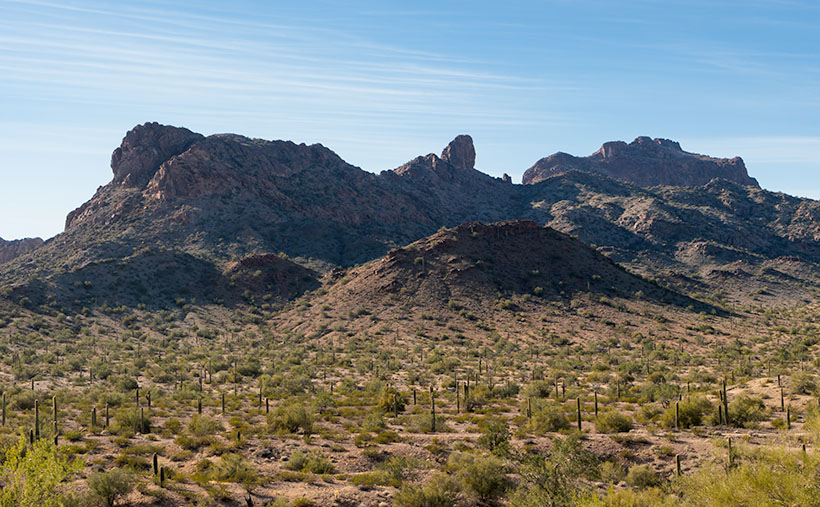
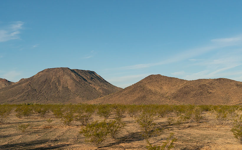
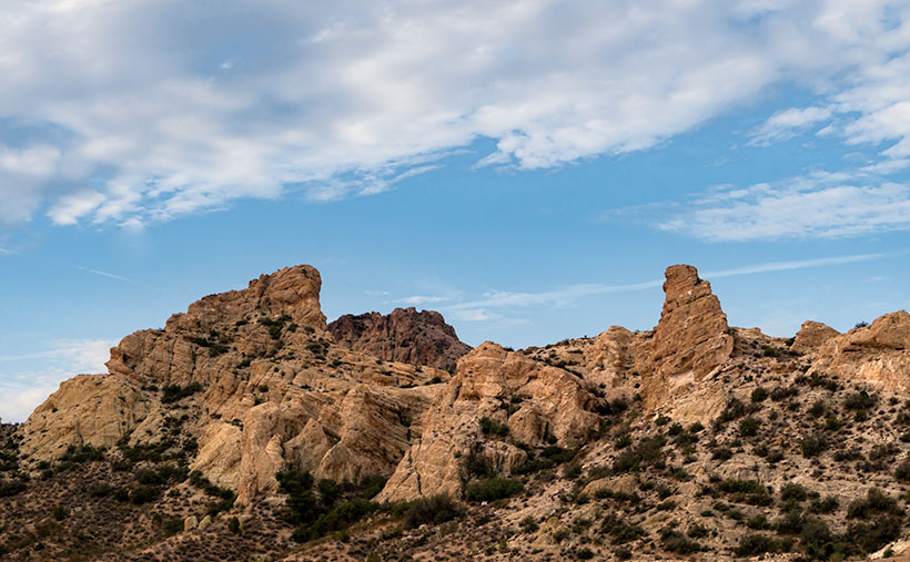
The actual purpose of our Willcox visit was to photograph the Chiricahua National Monument. After fifty years of living in Arizona, this was my first visit. It’s usually a half-hour drive southeast of Willcox. Still, we dawdled with a camera and stretched the trip to over an hour. The scenery along County Road 186 reminded me of California’s central valley and the Sierra Nevada foothills. Long butterscotch colored grass filled the broad Sulphur Springs Valley between the Dos Cabezas Mountains (Two Heads in English) on our east to the Dragoons on our west. Arizona ranges don’t tower over its valleys as the Sierra’s do, but at least the air was clear, and we could see all of the mountains.

My After Life - I found out that I can become a rural mail carrier in Cochise County even after I'm dead. That gives me something to do after I'm gone.
My After Life – I learned that I could become a rural mail carrier in Cochise County even after I’m dead. That gives me something to do after I’m gone.

On one of the many photo stops that we made, I was able to chat with the local postal carrier and got some great news. He told me that I don’t have to be useless after my death because I can always get a job delivering mail for eternity. You saw my after-life job delivering mail if you watched Funny Farmthe movie. All I have to do to qualify is pass the Civil Service Exam.

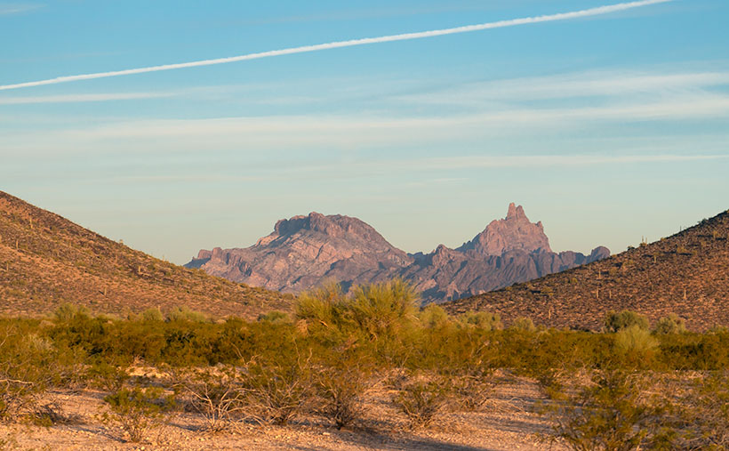
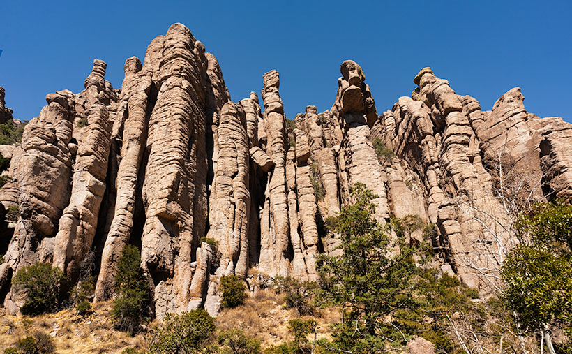
The route coming out of Willcox ends at the Junction of county roads 186 and 181, and you turn east on the latter. You pass from open range into a canyon as you head into the Chiricahuas. Within four miles, there’s a pay station. It’s closed due to the pandemic, so the Rangers collect any fees at the visitor’s center. Immediately on the right is a small family cemetery where the Erickson’s rest under shady oak trees. The Erickson’s are the family that homesteaded here after he retired from the Army at Fort Bowie. They established a ranch along Bonita Creek called Faraway Ranch because it’s far away from anything. Their daughter, Lillian, and her husband, Ed Riggs, welcomed guests to the homestead to promote tourism. They built many of the trails still in use, allowing visitors to wander among the unusual columns of eroded stone.

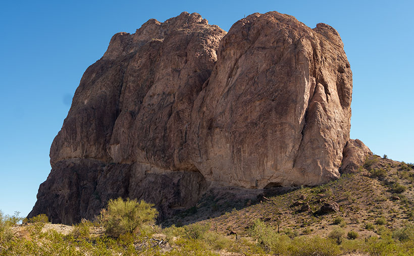
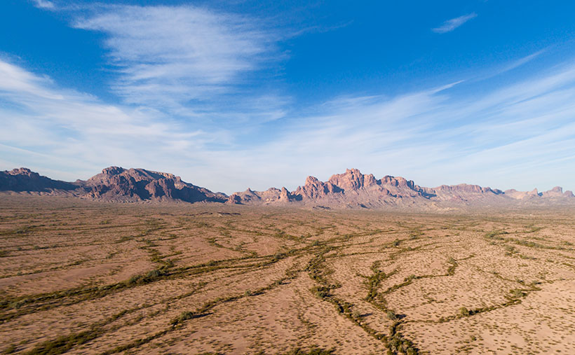
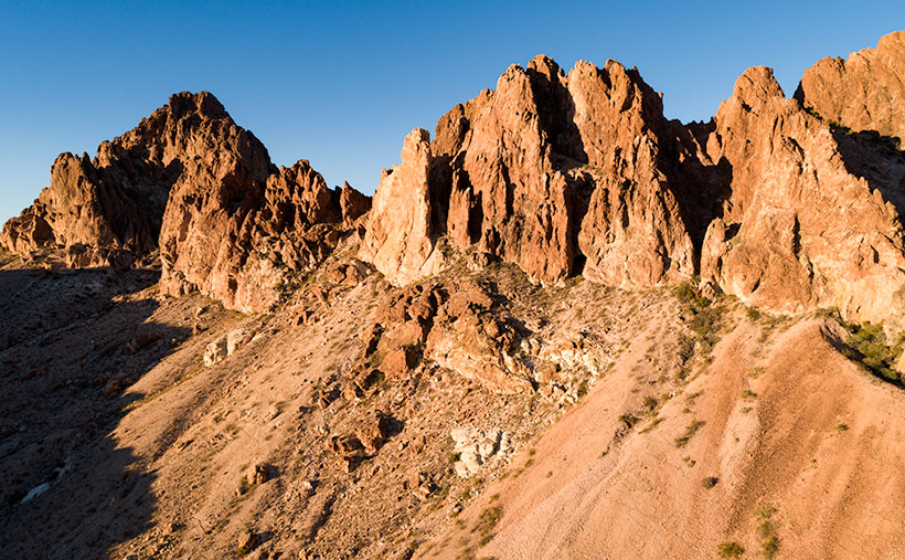
There’s only a single road in the monument that runs from the entrance, past the visitor’s center, climbs through Bonita Creek Canyon, and winds along the ridge of the park’s eastern boundary. Along its length, there are numerous stops, pull-outs, and parking areas where you can stop and take in the view, like this week’s picture that I call Organ Pipes. However, if you want to immerse yourself in the complete gestalt, you should plan on hiking one of the trails. They range from a half-mile to a couple of miles long. You can also link several trails and make your feet suffer to your heat’s delight.

Chiricahua National Monument only has one small campground, which fills quickly—especially during the season. There are only two towns with hotels, Willcox along Interstate 10 and Douglas at the Mexican border if you’re willing to drive further.

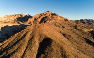
The Organ Pipe Formation captured in this week’s image is one of the first displays after the visitor’s center. The columns rise several hundred feet above Bonita Creek and are mirrored on the other side of the road by similar rocks. There wasn’t a way for me to hike above the trees to get a better shot. This picture does not do justice to their scale.

You can see a larger version of Organ Pipes on its Web Page by clicking here. Next week we will hike one of the short trails to look at the park’s natural sculptures. Come back to see what we found.

Until next time — jw


What’s The Point  Picture of the Week

The Point - Afternoon shadows grow long on a portion of the Eagletail Mountains.
The Point – Afternoon shadows grow long on a portion of the Eagletail Mountains.

After last week’s rant about the failed hike Fred and I attempted in the Eagletail Wilderness Area, some of you have probably concluded that I’ll never do that again. I understand; I had those feelings too. After all, why attempt a 7-mile hike when a) I don’t enjoy hiking, and b) I’m not good at it? Well, it’s because I love being in the wild, and I find it revitalizes my soul.

I didn’t become a nature-lover from my father. He was born and raised in Pittsburgh, Pennsylvania, and grew up in a neighborhood derogatorily called Polack Hill—now Polish Hill. There wasn’t room for nature in the middle of Pittsburgh’s industrial district. I remember seeing the Allegany River between the warehouses from my great-grandmother’s back porch, but no one fished it. The steel mills polluted it so much that the catfish were discolored and had three eyes—like the fish in The Simpsons. Dad didn’t hunt, and the fishing trips he took me on were to fish farms.

It was Ansel Adams that sparked my interest in the natural world. As an impressionable young photographer, I was awed by his works. I wanted to see and shoot all the beautiful places in his pictures. It wasn’t until I moved to Phoenix and joined my brother-in-law on camping trips that ignited my love of the outdoors. He and his friends had the right gear to live well in the wild. That gang taught me that everything tastes better in the dirt. There was something out there that made me feel alive, even if we only swapped Jack Daniels flavored lies in the searing heat of a roaring cowboy fire.

Eagletail Brittlebush - A sure sign that spring is near in the Sonoran Desert, is when the Brittle Bush sprouts new blue-gray leaves.
Eagletail Brittlebush – A sure sign in the Sonoran Desert that spring is near is when the Brittle Bush sprouts new blue-gray leaves. Yellow flowers will soon cover the desert floor.

That feeling of adventure is addictive. I need a regular fix. Although I’m happy to roll down my car window and shoot mountains through it, the thrill is more significant when I know that I’m seeing something most people haven’t. Even though Fred and I failed to find the petroglyphs, we filled our memory basket with petrified wood, rose quartz, and signs of wildlife. I’m not sure if or when I’ll go back to the Eagletails. Other places sing the Sirens song for me.

This year is the beginning of my fourth quarter. Although I can’t see it from here, the end of the road is waiting. With every passing year, I better appreciate nature’s importance. That’s why I’ve joked with Queen Anne to place my ashes on Utah’s Powell Peak—but save my eyes. Like that weird little Microsoft Word assistant—Clippy—put them in a formaldehyde-filled jar so I can still look around. I can hardly wait to see the look on some poor camper’s face when they discover me watching them set up their tents.

This week’s picture is of a mountain ridge inside the Eagletail Mountains. I named it The Point for the granite dome at the center. It’s smaller than Courthouse Rock I showed last week. I shot this image after Fred got back from his reconnoitering trip. While I waited, I watched the afternoon shadows grow into a pleasing composition. You can also see the Ben Avery trail that we meant to hike. The flat Jeep trail near the bottom runs from left to right.

You can see a larger version of The Point on its Web Page by clicking here. Next week, Queen Anne and I begin a new adventure. I’ll give you a hint; it’s someplace in Arizona that I’ve never visited. Come back then and see what we’ve discovered.

Until next time — jw

Courthouse Rock Picture of the Week

Courthouse Rock - The huge granite monolith that attracts climbers and base-jumpers to the Eagletail Wilderness Area.
Courthouse Rock – The massive granite monolith attracts climbers and base-jumpers to the Eagletail Wilderness Area.

When you were in school, did you learn about the Lewis and Clark expedition—the party that explored the Louisiana Purchase and discovered the first Starbucks in what’s now called Seattle? Sadly, when it comes to the outdoors, my buddy Fred and I will never rise to that level of notoriety. We’ll most likely go down in history more akin to Laurel and Hardy.

Fred and Jim's overlapping skill sets - When we get together, things don't always go as we plan.
Fred and Jim’s overlapping skill sets – Things don’t always go as we plan when we get together.

Don’t get me wrong, Fred is a brilliant man. After all, he is an engineer, and I can write complete sentences, so when apart, we can navigate the world and safely return home (to the amazement of our wives). But when we go out together, our skill sets overlap like in a Venn diagram, setting up a thinking interference pattern that causes things to go south.

To finish up this month’s project, the Eagletail Mountains, I needed a couple more photos that are close to the subject. Since it’s a wilderness area, that meant hiking. I spent time researching and found a perfect trail on AllTrails. It’s only 3 1/2  miles each way and goes to Indian Springs. There, we should see a spring and a rock wall of petroglyphs. They described the hike as “the easiest trail in the world. It’s an old mine road with little grade change. A baby can do it.”

I began calculating. I walk at 2.2 miles per hour (I measured it using my hand-held Garmin), so 2 hours in, snap a couple of shots, 2 hours out, and add four hours of drive time down and back. The outing should easily take an afternoon. I asked Fred if he would be interested (somebody needed to carry me out when I fell). He said, “Sure.”

Monday at noon, I tossed on some comfortable jeans, my whitest Tee shirt (so the rescue helicopter could spot me), and a baseball cap. I drove to Fred’s house to pick him up. He opened the front door dressed like an L.L. Bean model, with a freshly pressed ‘cool-shirt,’ safari hat, day pack, and walking sticks. He was gorgeous.

It was a beautiful day, and we spent the two-hour drive talking about the hike and sharing the maps we brought. Fred downloaded the AllTrails map onto his iPhone; I had printed the directions to the trailhead; we were ready.

Mistake #1: The easy part was getting to the Gas-Pipeline road, but we had to count the miles to the turnoff. As Fred read the instructions, I watched the odometer. When the instructions said, “At 1 ½ mile, turn onto an unmarked road,” a road appeared on the left. We turned, but the sign that they promised wasn’t there. We continued anyway and came upon a group of young men camped at its end. This place must be our spot, so we parked.

Mistake #2: The boys/men were friendly and were sitting around packing parachutes. If we were in California, I would have expected them to be waxing surfboards. They had come to Courthouse Rock to climb the monolith and then jump off with a parachute—even though the rock wasn’t in danger of crashing. They asked why we had come. They said we were on the wrong road when we told them about the trail. They said we needed to return to the pipeline road and go another mile. Fred and I looked at one another, the maps, and the app. Since the trail was just over the hill, we ignored their directions—like any person holding a man-card should.

Mistake #3: We started hiking cross-country diagonally toward the trail. “Surely, it must be over that low ridge, and we’ll see it from the top,” I told Fred. We hiked to the ridgeline and saw——another hill. We began the long trudge to its top. What we didn’t realize at the time was that we were climbing Courthouse Rock’s talus slope. The rock must have been significantly larger at one time because sharp granite chips covered the ground. They had flaked off the enormous tower, making the footing lose. Falling on them would hurt—a lot.

Fred the trailblazer - Fred hikes to another ridge to see if it's the last of our hike. It wasn't.
Fred the Trailblazer – Fred hikes to another ridge to see if it’s the last of our hike. It wasn’t.

After an hour of hiking uphills and over gullies, we reached a point where we could see the trail. It was on the other side of a deep wash. That meant we could get to it if we could cross the dry creek, but it was still a half-mile away. We only managed to cover less than a mile during the past hour. I was ready to quit but could see yet another ridge on the horizon. I hoped it was the last. Fred volunteered to continue seeing if it was our summit while I sat, drank water, and caught my breath. He confirmed that it wasn’t, so we started back when he returned.

Instead of retracing our steps, we went down into the wash, where we could walk the sandy bottom back to the Jeep in half the time. We had to explain our failure to the base-jumping dudes when we reached the camp. “Yeah, I thought you should drive to the other road,” one of them graciously taunted. Since we were in the area, we did. We found the second road with signs, parking, and an informational kiosk. At least we’ll know should we ever go back, but the two-hour drive home was nearly silent for now.

I shot this week’s picture that I call Courthouse Rock at the beginning of our hike. It’s of the enormous granite monolith from its west side. The 20-foot palo verde tree gives scale, so I’m glad the tree photo-bombed my shot.

Click here to see a larger version of Courthouse Rock on its Web Page. Next week, we’ll finish our Eagletail Mountain visit and move on to another project. Hopefully, somewhere I can drive.

Until next time — jw

Eagletail Peak  Picture of the Week

In last week’s article, I mentioned that the Eagletail Wilderness encompassed two desert mountain ranges and the Sonoran Desert basin that lies between them. The Eagletail Range was one, while the other is a chain known as Cemetery Ridge. After I gave you their name, I made an offhand remark about how they got that name. Well, I accepted that question as this week’s homework assignment, boys and girls. Here’s what I found—nothing.

Cemetery Ridge - A 16 mile-long chain of mountains that make up the southwest flank of the Eagletail Mountain Wilderness Area.
Cemetery Ridge – This is a 16 mile-long chain of mountains that make up the southwest flank of the Eagletail Mountain Wilderness Area.

Well, that’s not wholly true because, in my handy Arizona Place Names book, there is this entry:

“This sixteen-mile-long and two-mile-wide, low range was the scene of the killing of several prospectors in the 1870s, according to local stories. Their bodies are said to be buried on the ridge (sic), which is also known as Cemetery Hills.”

When I read that, I thought, “Alright, there’s an interesting historical story to tell my loyal readers.” So I, as the unofficial Marshall Trimble understudy, started a week of research that would have made Jimmy Olson proud. I wanted to find out what miners, who killed them, why, and where are they buried. I asked Alexa, Siri, Cortana, and Google’s unnamed assistant. None of them knew nothin’.

I did find out that I’m not the only person searching for those answers. Google referred me to the Desert Mountaineer blog. There I found the anonymous author had written a three-part journal covering Cemetery Ridge. The writer is a pretty good storyteller and photographer, but his passion is climbing mountains, and the photographs are incidental, kind of the opposite of what I do.

His three-part saga covers four days of driving the same roads I did, looking for graves. He travels with his dog, sleeps in his truck, and often stops to climb the mountains he passes—sometimes two or three in a day. I’m impressed! Anyway, after exploring the entire length of Cemetery Ridge, he didn’t find our legendary graves. He does mention the place where Deadman Wash crosses Cemetery Ridge on the west side. If ever there were a place to look, that would be where I’d start. It has all the intrigue of a pirate’s treasure map.

Framed between two of the Cemetery Ridge Mountains, Eagletail Peak's feathers lit by the sunrise.
Framed between two of the Cemetery Ridge Mountains, Eagletail Peak’s feathers lit by the sunrise.

I shot this week’s image along the Arlington-Clanton Well Road on the south side of Cemetery Ridge. The Ridge’s mountains (like hills really) appear and disappear in a straight line for 16 miles. At one of those places where they slip below the surface like a giant sea-serpent, I saw Eagletail Peak framed and lit by the sunrise. You can make out the ‘tail feathers’ sticking up at the top in the picture. I want to explain that the Eagletail Wilderness is directly under the Los Angeles-Phoenix flyway, so contrails are part of the natural landscape, but they won’t let me fly my drone there.

You can see a larger version of Eagletail Peak on its Web Page by clicking here. Next week we go hunting for more treasure in the Eagletail Range. Come back then and see if we were successful.

Until next time — jw

Eagletail Mountains Picture of the Week


Eagletail Mountains - The Eagletail Mountain Wilderness Area is an hour west of Phoenix, and south of Interstate 10. Since you have to hike to see the good stuff, it's challenging for me to photograph properly.
Eagletail Mountains – The Eagletail Mountain Wilderness Area is west of Phoenix and south of Interstate 10. Since you have to hike to see the good stuff, it’s challenging to photograph correctly.

I find some places where it is difficult to photograph properly. Most of those are wilderness areas. Because they’re not accessible by road, you have to hike to get to the good stuff; that’s exciting visually. You know by now how I feel about hiking—I’m vehemently against it. However, sometimes you have to do things that make you uncomfortable.

The Eagletail Mountains are one of those places. Plenty of old jeep trails are running through the area, but since it was declared a wilderness and set aside in 1990, you can’t drive on them. Instead, you have to hike anywhere within its boundaries.

I last visited the Eagletails in 2003—when I first created my Website. Since I routinely update the site with newer and better photos, I discarded those shots long ago. I needed a new project, so I decided to revisit the Eagletail Wilderness and try my luck again.

There are two mountain ranges in the Eagletail Wilderness. Foremost is the Eagletail Range that runs north-south. If it were a hand on a clock, they would be in the 11:00 position. The other range is Cemetery Ridge (hmm, there’s got to be a story behind that name), a line of mountains that run northwest-southeast, or 9:30-10:00. Most of this wilderness fits within this triangle between the two ranges. That’s the justification that Congress used to preserve it. It is a complete example of two mountain ranges separated by a flat Sonoran Desert basin.

This week’s picture is of the western slope of the Eagletails. It’s an aerial shot taken with my drone. Since I can’t fly into a wilderness, it’s as close as I could get from the east side. It shows the jagged ridgeline with Eagletail Peak—the high point—at center-right. If you got closer, you’d see its top has several granite spires resembling feathers—so its name is descriptive.

The trouble is that the interesting geologic formations and petroglyphs are on the other side. For February, my challenge is to see how far I can walk in and show you what’s there. It’s been several years since I last twisted my ankle, so I’m about due.

You can see a larger version of Eagletail Mountains on its Web Page by clicking here. Next week, we move south and get a shot, including Cemetery Ridge. I promise to see how it got that name. Come back then and see what we found.

Until next time — jw

Sunset Wall Picture of the Week

Alright, class, settle down. Get out a sheet of paper and a pen, then put away your backpacks. Today we’re starting with a pop quiz. There is only one question, and you have 15 minutes to answer with 10,000 words—or more. You must cite your sources. Spelling and punctuation will be graded. Are you ready? Your question is, “What do Memphis, Tennessee, and Kingman, Arizona have in common?”

I have talked before about old trading trails morphing into the well-laid-out highway system that we have today. Most of us don’t care how it happened, and we just drive on them. They think that Eisenhower signed a paper in 1956, and the freeways just popped into existence. I think that’s because people younger than me—and that’s pretty much everybody—didn’t experience the change first hand. Our forebearers built most roads over existing paths, and there are reasons someone blazed those original paths. Mark Knopfler describes this phenomenon well in his 1982 song Telegraph Road from the Dire Straits album Love Over Gold.

There have been trading trails across Northern Arizona since the first Pueblo inhabitants. European settlers didn’t use them much because the New Mexico territory was Spanish. Their roads came up from Mexico to towns like Santa Fe and the Old Pueblo at Tucson. Those roads followed the Rio Grande and Santa Cruz Rivers because there was always reliable water. The rest of the desert was a wasteland. What changed that? It was gold.

In 1848, James Marshall discovered gold at Sutter’s Mill in California. In less than two years, California became a state—that’s instantaneous in government time. They needed to move goods and people to the Golden State—and get the gold back to Washington. But, there were no east-west roads, so they put Captain Lorenzo Sitgreaves in charge of a surveying expedition, and he laid out a railroad route around the 35th Parallel.

Then in 1857, the Fed’s paid Edward (Fitzgerald) Beale to build a wagon road from Ft. Smith, Arkansas, to Los Angeles—again along the 35th Parallel (remember, Tucson was still in Mexico). He built his road in a year using camels because they needed less water and food than oxen and horses. By all accounts, it wasn’t much of a road, but Beale bragged that it was the shortest route by 300 miles and “It is the most level: our wagons only double-teaming once in the entire distance, and that at a short hill . . .” His road became the Santa Fe line in 1880, then Route 66 in 1926, and finally Interstate 40 in 1978.

SR 68 through Union Pass - Arizona State Route 68 (on the right) as it enters Union Pass through the Black Mountain Range.
SR 68 through Union Pass – Arizona State Route 68 (on the right) as it enters Union Pass through the Black Mountain Range.

His wagon road wandered a bit from the 35th as it meandered across the desert, but wagon tracks are visible in places on Google Earth. As vehicles became more efficient, each of the subsequent roads shortened its length. Some silly people hike the old road just for giggles. I’m not that ambitious. However, I do know of a place where you’ll be in Ed’s footsteps. Yep, you guessed it. It’s our Union Pass on SR 68. While Sitgreaves went through Oatman, Beale found a more accessible way to Fort Mohave and his river crossing.

Sunset Wall - Layers of volcanic rock upended vertically in the Black Mountain Range.
Sunset Wall – Layers of volcanic rock upended vertically in the Black Mountain Range.

I took this week’s picture on the west side of Union Pass, and it shows layers of lava and ash (tuff) that have been turned horizontal by geological forces. As Don Sprinkle commented in another post; “. . . just like the Grand Tetons.” It was sundown as I took this photo, and that’s why the ordinarily dark rock has a beautiful red glow, and that’s why I called it Sunset Wall.

So, back to your quiz; I’m going to let you grade your papers. What did you answer to: What do Memphis, Tennessee, and Kingman have in common? If you said that they are both along Interstate 40, you get 50%, and if you said that they both have a Beale Street, you get another 50%. I must add that there is a difference too. While Kingman knows who they named their street after, according to the Wikipedia entry for Memphis’ Beale Street, nobody remembers who Edward Beale was, which I find amusing. Maybe it’s forgotten because he was a Union Naval officer.

You can see a larger version of Sunset Wall on its Web Page by clicking here. Please come back next when we begin December’s project and new pictures.

Until next time — jw

Union Pass  Picture of the Week

Queen Anne, my darling wife, flew east last month to join her sisters for a week in New England. Supposedly it was an Autumn-Leaves tour, but they went to Salem in October during a full moon. I’m no math whiz, but I know what you get when you put four and ten together. That’s right—witches!

I’m a big boy, so I wasn’t about to spend my time alone sulking and drowning my sorrows in a tub of Cherry Garcia—I intended to treat myself to a night on the town—another town—in another state. Laughlin, Nevada is an easy three-hour drive from here via Kingman, across Golden Valley, through the Black Mountains, and down to the river. I booked a cheap casino hotel room for Wednesday night and set off determined to lose some money on a craps table.

The downside of weekdays in Laughlin is that it’s mostly closed. The big weekend crowds are working, so the remaining patrons are retirees like me. Half of the restaurants are dark, and some of the casinos don’t open the gambling tables. You have to search for a place to eat and find some action, so that’s how I ended up at the Riverside Casino. They had a couple of working Blackjack tables and one craps table. I think the staff outnumbered the players when I joined. Two people were on the right of the stickman, so I claimed an open spot on the left.

Trying to get a feel for the player’s moods, I looked at the faces around the table. Because masks were mandatory, it was hard to tell who was doing well. A woman across from me wasn’t even a whole face at all—only a pair of brown eyes behind jewel-rimed glasses and silver-blue hairdo peering over the table’s edge. Just like my mom, her short hair had enough hairspray to keep it in place between weekly salon visits. She had a few chips on the rail pushed to one side so they wouldn’t block her view of the playing field.

I placed my bet; someone threw the dice a couple of times and lost. Then we all took a turn bouncing the dice off of the far wall when the silver-haired lady stood up. Until then, I didn’t realize she was sitting. Even when she stood, she wasn’t much taller. She scooped up her remaining chips into a clutch. I thought she was leaving. Instead, she began pushing a walker towards my side of the stickman.

As she maneuvered her tricked-out lavender walker behind the dealer, I saw that she had dressed to party. She had on a very sparkly silver lame top and black spandex pants—which, quite frankly, bagged a bit. Weirdly, as I watched her, I suddenly heard Lenard Cohen singing his tune—Closing Timein my head:

“…And the place is dead as Heaven on a Saturday night
And my very close companion
Gets me fumbling gets me laughing
She’s a hundred but she’s wearing
Something tight…”

When she got close, she spoke through her mask in a voice that comes from years of smoking Chesterfields, “Hey, big boy. You need a good luck charm.”

“Hi,” I smiled (a useless gesture behind my mask) and introduced myself, “I’m Jim.”

“Nat-ly,” she replied.

“It’s a pleasure to meet you, Natalie.”

“No. I’m from Flatbush. It’s Nat-ly,” she corrected with furrowed eyebrows.

“Sorry. What kind of good luck charm are you talking about?”

She explained, “Well, every high roller knows it’s good luck to have an attractive woman beside him while he rolls the dice. You’re alone, and I’m the best-looking dame in the joint.”

Just a glance around the room was enough to confirm to me that she was right. “What’s in it for you?”

“Well, you tip me each time I blow good luck on your dice.”

I was curious, “Do you do this for everyone?”

“Na,” she blushed and went on, “The girls and me spotted you the minute you came through the door.”

“That was because of my dashing good looks and natty fashion sense, I bet.”

“No. You’re the only man in the casino standing upright without a cane. You know how cougars are; we like ’em young and stupid.”

With that, Nat-ly positioned her seat to my right and plopped herself down. On my roll, she blew on my dice for luck. I even made my point once, so her luck wasn’t all bad. “You’d do even better if I hung off your shoulder,” she offered, “It’s only $20 bucks.”

I couldn’t imagine how she could reach that high given her stature, so my curiosity bettered me. I handed her a couple of chips. She reached down and pulled a cane from the tool rack attached to the walker’s side. Then she raised it and hung the crook over my shoulder and began gently stroking it back and forth. I almost burst out laughing, but she was so adept that it felt alright.

The next thing she said was, “For $5 more, I’ll play with your ear.” When I turned, she was holding one of those trash-grabbers for me to examine. I declined, so she slipped it back into its rack spot.

The night passed, the dice went clockwise around the table twice while we talked. She worked at the Mustang Ranch until the Feds seized it, and she retired. Since the Treasury Department was managing the business, she got a federal employee pension. After she quit, she moved south from Reno for a warmer climate and affordable housing. Now, she spends her free time watching the tanned muscle boys ride jet skis up and down the river.

I managed to hold onto my bankroll an hour and a half before it ran out. As I packed my things, I looked down and saw Nat-ly slumped over—asleep. I knew that the dealers wouldn’t let her stay at the table alone, and I didn’t want to wake her. So, I pushed her to the nearest quarter slot machine and parked her in front of it. I reached into my pocket and threw all but one of my quarters into the tray. The last, I stuck in the coin slot. I knew that security wouldn’t bother her as long as there was a bet on the table. With that, I left and went to my room. Tomorrow I have pictures to shoot, so the day will begin early.

Union Pass - To cross from Kingman to the river, you drive through Union Pass. Here we see layers of Tuff - volcanic ash - that was broken and tossed in the air when the Black Mountains were formed.
Union Pass – To cross from Kingman to the river, you drive through Union Pass. Here we see layers of Tuff – volcanic ash – broken and tossed in the air when the Black Mountains formed.

The last time I crossed through Mohave County’s Black Mountain Range was last year on our Oatman trip. I always find something new every time I travel through, which was the same on this excursion. As I drove through Union Pass, I made a mental note that I should get up early and shoot while the light was good. When the morning alarm went off, I got dressed in the dark, packed the truck, and headed to Denney’s for coffee and breakfast. I was determined to stop on the hilltop and photograph the beautiful rugged terrain. on the drive home

This week’s featured image is a part of my morning’s work. I call this photo Union Pass because that’s where I pulled to the roadside and walked up and down the highway shooting as quickly as I could. A thin gauze of clouds filtered the morning light, which is why the shadows are soft in this shot. That’s good because it shows the rock’s layer details. I believe they’re the Tuff that we learned about from Organ Pipe N.M. Tuff is volcanic ash that covers the ground in layers. Here we can see those layers have been broken and thrust into the air when the Black Mountains formed.

You can see a larger version of Union Pass on its Web Page by clicking here. When you come back next week, I’ll show another picture of my time hanging out in Union Pass.

Until next time
jw