Granite Mountain Picture of the Week

Fall on the Humphrey Wash- Usually the high-country aspen trees get all of the attention for their fall colors, but every so often, you can find some subtle color along the road.
Fall on the Humphrey Wash- Usually, the high-country aspen trees get all the attention for their fall colors, but occasionally, you can find some subtle colors along low-land roads.

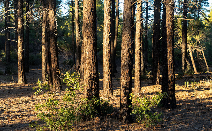
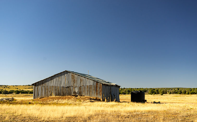
This week’s featured image (below) is the last from our Camp Wood Road excursion. It was taken a few miles from the route’s junction with Williamson Valley Road—also known as Yavapai County Route 5. You’re still in the middle of nowhere when you arrive at that intersection. Iron Springs is 22 miles south, Seligman is 30 miles north, and all dirt roads. I’ve already made a note of it for a possible future trip.

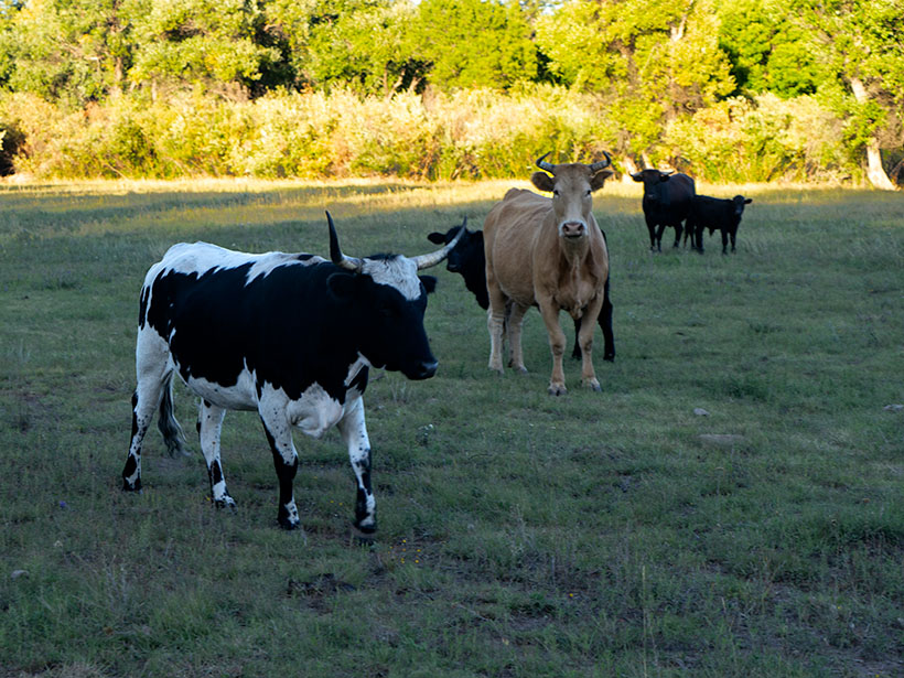
From the Sheridan Fire area, I talked about last week, Camp Wood Road descends from the pine-covered hills and mountains into Prescott’s flat grasslands. It’s a natural location for the sprawling cattle ranches of the past, and now it’s the target of developers selling one-acre McMansions. When I traveled to this area as a younger man, I could frequently spot grazing antelope. They’re a rare sight these days, and that makes me sad.

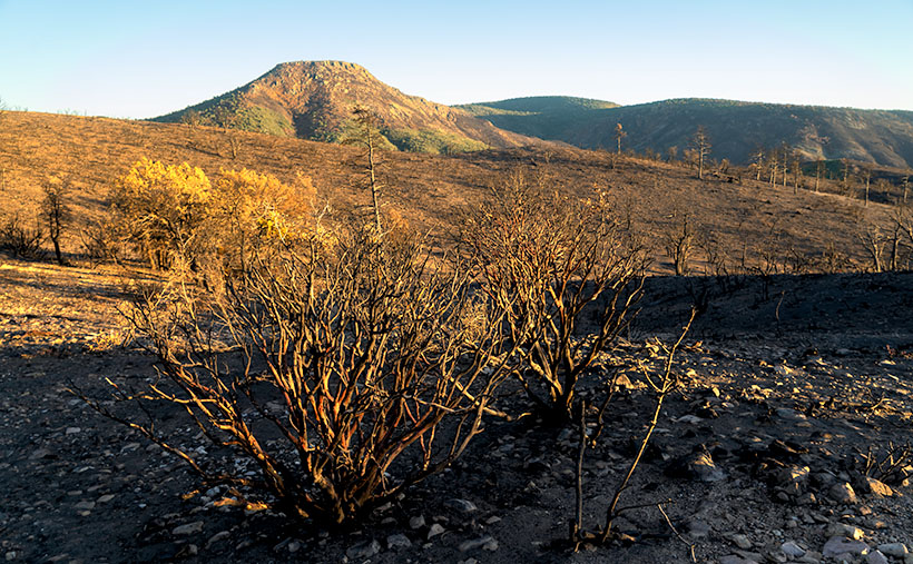
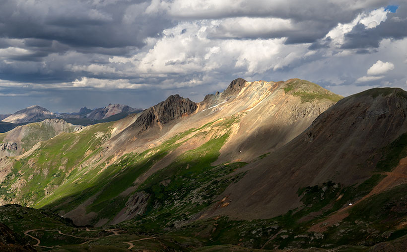
When Queen Anne and I set off on this photoshoot, we spent more time getting to Camp Wood than I estimated. It was already after sunset by the time we reached the road’s end. As we drove in the dim light, I knew I wanted to include the open grassland in the Camp Wood story, so we made a second trip. This time, we drove counter-clockwise—which is more accessible and a much faster way to get there. However, on the second drive, the sky was overcast, and someone had set the Bradshaw Mountains ablaze, which filled the air with smoke. I wasn’t optimistic about getting good shots. As it turns out, the fire was only a controlled burn, and the fire crews had it out by the afternoon.

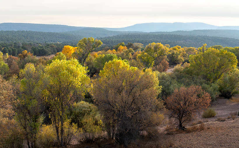
We found another change when we reached an area called Humphrey Wash on my maps. The broadleaf trees started turning color in the intervening weeks between our visits. Of course, this is Arizona, so they weren’t the bright colors you’d see in New England, but they were still worth getting out of the truck and getting them on film.

Granite Mountain
Granite Mountain – Under a vast sky filled with broken clouds with lingering smoke, Granite Mountain dominates the southern horizon from the Las Vegas Ranch in Williamson Valley.

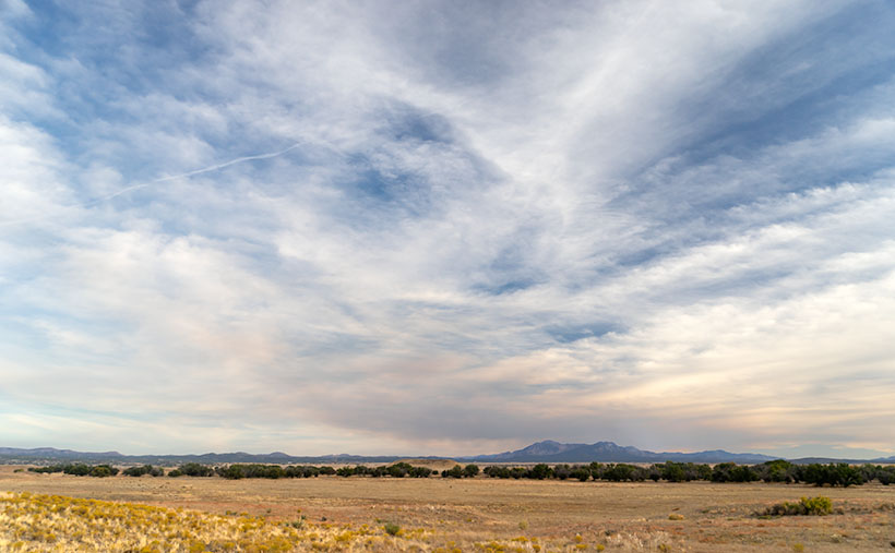
Further east on Camp Wood Road is a large ranch with two driveways. It’s the Las Vegas Ranch, and one of the entrances is along Camp Wood Road, while the other connects to the Williamson Valley Road—a dozen miles away. When we arrived, the sun was low, the overcast began breaking, and Granite Mountain was predominant on the southern horizon. I took two versions of that scene, but I think the second was better because of the cottonwood trees lining an unnamed wash. I called it Granite Mountain, and I wanted to show the Prescott grassland’s open space. Just as it is in real life, the sky dominates everything. In this photograph are all of the elements of that visit: the broken clouds, lingering fire smoke, Granite Mountain, and the vast open plain. I hope you enjoy it.

Click here to see a larger version of Granite Mountain on its Web Page. I hope you enjoy viewing it. It’s the start of a new month next week, so we’re off to explore a different Arizona back road, so be sure to come back and see what we’ve discovered.

Until next time — jw

Sheridan Manzanita Picture of the Week

Camp Wood Ponderosa - The late afternoon light adds a glow to a ponderosa pine grove at Camp Wood.
Camp Wood Ponderosa – The late afternoon light adds a glow to a ponderosa pine grove at Camp Wood.

East of Camp Wood, the road is wide and smooth as it rolls through the Santa Maria Mountain foothills. There are a few isolated places with washboards, but it’s quiet enough you might think that they paved it, although the plume of dust you see in the rearview mirror proves otherwise.

Queen Anne and I visited here the week after a heavy rain, so it packed down the dust, but the roadside troughs were full of debris. As we drove further, it looked like road crews had hosed the gutters with oil, because they were so black. We questioned if that was to keep the dust down, or were they preparing to pave the east end of Camp Wood Road. As soon as I got those questions out of my mouth, we rounded a bend and found a scene of utter destruction. On the north side of the trail, everything was normal, with pinions, chaparral, and gamble oak covering the landscape, but the south side was black and barren. Only charcoal-colored tree skeletons dotted the hills and valleys.

This road section was the location of the lightning-caused Sheridan Fire—one of those forest fires you watch on the evening news as they bomb the countryside with a fire retardant. The reporters tell you it’s near Prescott—but they’re always near Prescott—and it’s so remote that you don’t pay much attention. The fire started on August 5th, and it burnt through 22 thousand acres until early September rains finally put it out. I’ve never visited such a fresh burn site. Unbroken black ash covered the ground, and the rains washed some of it into the road gutters. The Forest Service blocked all of the side-roads, and hiking trails leading south with signs warning of fire danger.

Because Camp Wood Road is so wide here, it worked as an effectual fire break. The stark contrast between the left and right sides of the road drove home the destructive power of a forest fire. Although it looks like a barren wasteland now, within a few weeks, grasses will begin to sprout, and the fire area will renew itself. That’s how nature works.

Sheridan Manzanita - Red bark manzanita burnt in the 2019 Sheridan Fire near Camp Wood, Arizona
Sheridan Manzanita – Red bark manzanita burnt in the 2019 Sheridan Fire near Camp Wood, Arizona

When we got to a place where I could see Cottonwood Mountain as a backdrop, I stopped to take a few images. My favorite of the group is this week’s featured image. It shows burnt Manzanita skeletons in front of the flat-top mountain. Manzanita is one of my favorite plants because of its mahogany-colored bark, as you see in the photo. It only grows at higher altitudes in Arizona, and it’s hard to photograph because its dense round green leaves always hide the brightly colored branches. I called this image Sheridan Manzanita, and I hope you enjoy viewing it.

You can see a larger version of Sheridan Manzanita on its Web Page by clicking here. I hope you enjoy viewing it. Next week, we’ll make another stop along the Camp Wood road for yet another change of scenery. I hope you’ll join us.

Until next time — jw

Camp Wood Boulders Picture of the Week

After stopping to photograph the shed featured last week, Queen Anne and I continued our journey along the Camp Wood Route. From the building and corals, the road is better graded, so we were able to pick up the pace, and we soon reached the edge of a canyon called Connell Gulch. On the far side of the canyon are the 6400′ Connell Mountains rising from the east bank of a creek below.

From the canyon’s edge, the road descends northward, and at the bottom, the landscape flattens and opens into grassy pastures filled with cattle. It was only another mile or two before we passed the headquarters of the Yolo Ranch—a sprawling 110-thousand-acre ranch established in 1885 by Tip Wilder. As it turns out, we had been traveling on ranch property since passing the gate I mentioned last week.

Yolo Cows - Cows stand between their calves and a perceived threat.
Yolo Cows – Cows stand between their calves and a perceived threat.

Here, we saw an idyllic valley with meadows and ponds, surrounded by ponderosa pine-covered mountains. Behind fences, there were a variety of grazing cattle. We even spotted a herd of deer, which were too skittish to let me get near and take a good photograph. Yolo is a working cattle and guest ranch, but I’m not sure they still offer accommodations. Authors have used it as a location in books, and the farm was the subject of a film documentary. In 2010, Yolo Ranch was for sale with an asking price of 12 million dollars, and I found the sales brochure online if you want to know more. It must be a peaceful place to live, but I’ll bet the TV reception is lousy.

Back on the road, reaching Camp Wood didn’t take long. It was only a short distance on the tree-lined trail. This area was initially called Kymo by Paul Wright. According to Arizona Place Names, he was from Kentucky, while his wife was from Missouri. A decade later, the U.S. Cavalry—led by Captain Wood—camped here on a scouting expedition, and the postal service chose Camp Wood for the post office in 1926.

I had a good feeling about this area. I thought that it would make a good campsite in milder weather. The elevation is 5800′, so the temperature would be excellent in spring and fall. Having a cup of coffee in the chilly mornings is always a good thing. There aren’t any facilities, water, or electricity, but that’s roughing it.

Yolo Cows - Cows stand between their calves and a perceived threat.
Camp Wood Boulders – In the late afternoon sun, granite boulders glow against a clear blue sky.

When we got to the Camp Wood area, the sunlight already had a lovely golden glow, and off the road a distance, it highlighted a mound of granite. I hiked to them and captured the moment in this week’s featured image, Camp Wood Boulders. I like how the afternoon light highlights granite before a clear blue sky. I’m also happy with the red-barked ponderosa frame in the scene.

Click here to see a larger version of Camp Wood Boulders on its Web Page. I hope you enjoy viewing it. Next week, we’ll make another stop along Camp Wood Road for an entirely different scene. I hope you’ll join us.

Until next time — jw

Tin Shed Picture of the Week

It was the fourth article about my time shooting pictures in Colorado’s San Juan Mountains when Queen Anne burst into my office—all akimbo—and began scolding me. “Fred and me this, and Fred and me that. I haven’t had press in a month.” I felt like the guy in that Toyota commercial trying to answer his wife’s question. “I’m sure there’s a right answer here.” I quickly flipped through my brain’s Rolodex of apology cards, before I realized she was right. I had to change tactics, “If you want press, you have to put your butt in the truck.” I had her.

Last week, I announced that I was leaving for one of my back-road photoshoots, and I wouldn’t be back until after dark. I packed my gear and went into the house to grab my cooler stuffed with water and snacks. When I got back to the garage and jumped into Archie’s driver’s seat, guess who was sitting shotgun? Yes—it was Her Highness.

Now that her ego is satiated, I can tell you about October’s topic. I picked out a back-road that goes from Bagdad to Williamson Valley—northwest of Prescott. On my Gazetteer map, it’s identified as Behm Mesa Road, but it had several other names as we drove it, like Camp Wood Road, Forest Service 21, or Yavapai County Route 68. The map says it’s broad and well-graded, so a passenger car should make it, but there are sections on Behm Mesa’s shoulder that are rough and rutted, so I’d feel more comfortable driving at least a pickup truck with some ground clearance.

The terrain starts in Bagdad with large boulder fields interspersed with grassy flats on the mesa tops. As the trail gains elevation, the trees change from scrub oak to juniper and ponderosa pine near the Santa Maria Mountains.  After that, the road descends into the open grasslands found around Prescott. There are a couple of cattle gates that you have to open (and close) as you cross private ranches. Most of the route’s middle section runs through the Prescott National Forest, including a part along the edge of last Augusts’ Sheridan Fire. It’s weird/unusual to see a healthy forest on the road’s north side while the south side is black and barren.

Tin Shed - An old corrugated tool shed along the Camp Wood Road.
Tin Shed – An old corrugated tool shed seen along the Camp Wood Road.

I took this week’s featured image near our starting point. As the road leaves Bagdad, you slowly travel on the shoulder of Behm Mesa—where the rough part is. September’s heavy rains may have been the cause of the ruts, and the county hasn’t regraded it. Shortly after it makes its way to the mesa’s top, you reach the first gate at a ranch house, with black cattle hanging around a water tank. Just past the tank was this tin shed in a golden grass field that had a nice contrast against the deep blue sky (opposites on the color wheel). You all know that old buildings—like this one—are a favorite subject of mine, so I had to get out and snap a picture. I call it Tin Shed.

You can see a larger version of Tin Shed on its Web Page by clicking here. I hope you enjoy viewing it. Next week, we’ll have another image to show from the drive that Queen Anne (she gets make-up press) took on the Camp Wood road.

Until next time — jw

Poughkeepsie Gulch Picture of the Week

Even though we had to wing it, I think that the day in the mountains Fred and I had was a very successful adventure. We both got a lot out of it. Fred was able to put his—new to him—Toyota FJ through its paces, we saw some beautiful rugged country, we took a lot of pictures, and we came back in one piece. When we got back to base camp, our wives—Deb and Queen Anne—knew we had a good time from the big bug-stained grins on our faces, and the incessant chattering about our day.

We visited four of the two dozen high passes in the San Juan Mountains, and those were the day’s high points (pun intended) of our trip. Coincidentally, that’s enough material for a typical month’s worth of blog posts. But September has five Sundays this year, so I get to show you another picture that I took; of the twenty-two keepers, this one is my favorite.

I don’t usually work this way. When I’m out alone with my camera, I try to work a scene. I’ll shoot several angles, zoom in and out, add or remove elements in the composition, or maybe wait for better light. When I’m back at my desk, I’ll review the raw files and pick out the best. I don’t bother processing most of my shots. In Colorado, we covered a lot of area in one afternoon, and I was just along for the ride, so I snapped pictures when I could before moving on. For most of the day, the light wasn’t to my liking, but the mountains were strong enough to stand up in less than ideal conditions. As dinner time approached, the sun’s color began to warm, and the scattered clouds cast shadows on the peaks.

Poughkeepsie Peak - The late afternoon sun shines on the top of Tuttle Mountain, which overlooks Poughkeepsie Gulch.
Poughkeepsie Peak – The late afternoon sun shines on the top of Tuttle Mountain, which overlooks Poughkeepsie Gulch.

We were almost done for the day, and as we approached Hurricane Pass, I saw this scene on the road overlooking Como Lake. I consider it the best of the day. It’s the fish you pull from the creel after the guys have finished laughing at the other minnows from your basket. It’s called Poughkeepsie Gulch. In this image, the warm afternoon sun is shining through a hole in the clouds on Tuttle Mountain’s top, which is otherwise covered in cloud shadows. The 13,203’ peak overlooks Poughkeepsie Gulch and down there, you can see the road the rangers warned us was too advanced for amateurs like us.

You can see a larger version of Poughkeepsie Gulch on its Web Page by clicking here. I hope you enjoy viewing it. Be sure to come back next week when we feature the scenery from another Arizona back road.

Until next time — jw

Sun Showers Picture of the Week

The day was getting late, and before Fred and I could go back, we needed to find one final pass to cross and return to Silverton—and eventually Durango. When we stopped to enjoy Lake Como—last week’s photo—it turns out that we were already near Hurricane Pass. Unlike the other passes, we didn’t have to crawl down one mountainside and up another. Instead, the road followed the ridgeline for a half-mile, and voila.

Unfortunately, Hurricane Pass wasn’t as photogenic as the others that day. The road simply turned east for a bit before disappearing down a crack. Of course, the crack opened into a gulch, then a river valley as we descended 5,000 feet into civilization. It was an anticlimactic way to end the day. The trail was soon gravel followed quickly by asphalt; with guardrails, of all things.

Sun Showers - Although small clouds filled the sky, the only rain we got was a sun-shower.
Sun Showers – Although small clouds filled the sky, the only rain we got was a sun-shower.

But don’t worry, I come bearing gifts. All during our outing, puffy little clouds filled the sky. They seemed to bump into one another like the balls on a billiard table. Then they would part again leaving large patches of blue sky. On our way down the hill, it started to rain—while the sun was shining. As we rounded a bend in the road, the sun appeared in one of those patches and backlit the mountainside. It’s one of those moments where the grass becomes iridescent and glows. I’ve seen this before in New Zealand. I failed to capture it there, but I think this week’s image is close. I call it Sun Showers. The mountain that we’re looking up as maybe Hurricane Peak, but I’m not sure. In case you’re wondering—yes, those are the Sun’s rays at the top. Did I tell you about the steep angles we experienced during this trip?

You can see a larger version of Sun Showers on its Web Page by clicking here. Be sure to come back next week when I’ll show you my favorite image from our adventure exploring Colorado’s San Juan Mountains in Fred’s Toyota—oh, sorry—Fred’s Jeep.

Until next time — jw

Lake Como Picture of the Week

Lake Como as seen from the top of Calaifornia Pass.Lake Como – A little alpine lake from California Pass in Colorado’s San Juan Mountains.

Something is intoxicating about standing on a mountaintop. You get a sense of accomplishment—an incredible buzz—while taking in the view. As you spot familiar landmarks, the map you carry around in your mind gets updated. I can understand the addition mountain climbers have to the highest peaks. I’m just too lazy to be one of them, and you won’t catch me on the climbing wall at the local gym—or inside the gym in the first place. Spending a day with Fred driving his FJ up-high passes in the San Juan Mountains was good enough for me.

When we decided not to spend all day driving Colorado’s Alpine Loop but drove up two of its passes, we wanted another challenge. The first ascent was scary, while the second was not so much. I felt like a kid on a swing urging his parents to push harder. “Again,” I shouted. So, we stood on Engineer Pass with the map spread over the hood, looking for another route back to Silverton. After all, we didn’t want to go back down the way we came. That was along the Animas River and was flat and dull. We agreed on a route that would take us over two more passes before dropping back to Silverton via Cement Creek, and that meant that we’d have first to drive back down to Animas Forks.

From the ghost town, we headed west up California Gulch. Going in this direction, the road ran straight ahead for several miles and appeared to end midway up California Mountain. Several times, I’ve traveled roads without a clue what’s ahead. For example, Interstate 15 is heading north out of Mesquite, Nevada. As it leads for the Beaver Mountains, you can’t pick out where the freeway climbs over them. I always involuntarily back out of the gas in case the road suddenly ends—like against the mountainside. At the very last moment, the Virgin River Gorge opens and swallows the highway. I was getting that feeling now.

It wasn’t until the perceived end of the road that it turned on itself and climbed behind a side ridge that hid the route from below, and as we drove around the bend, the trail went vertical. I questioned our decision to go this way because this was undoubtedly the beginning of the roller coaster from hell. Fred managed to keep all four wheels on the ground while his truck grunted its way up the grade. When we reached the top, as with the other passes, there was a spot to park and look around. When I got out, I decided a box of Depends would be a handy accouterment on these trips.

But the view! The light was coming in, and there were great shots back at California Gulch, and in front was this pretty little alpine lake—Lake Como—on the other side. I have seen pictures of places like these in magazines, but I’ve never been to one. It was breathtaking—well, 13,000 feet is stunning enough, but you know what I mean. I snapped several variations of this photo, and we eventually drove down to the lake where Fred tried to park over an open mine shaft, but that’s another story. This week’s featured image is the version I liked best because of its composition and color details. I call it Lake Como. I hope you like it.

Don’t let your eyes miss out—feast them on an even grander version of Lake Como right here (Jim’s Page)! Buckle up because we’re diving back into Colorado’s enigmatic San Juan Mountains aboard Fred’s Toyota next week. Trust me, you won’t want to miss this!

Until next time — jw