Five Cairns Picture of the Week

If you’ve ever hiked a backcountry trail, you know about cairns. They’re the road signs hikers use to stay on track. They’re simply piles of rocks high enough to be seen and reassure travelers that they’re following the right path. According to Wikipedia, cairns have been around throughout time all around the world.

I don’t know who has the time to build and maintain these stone piles, so I’ve concluded that it must be the Pixies. If you think about it, who else has the skills to precariously balance rocks on top of one another that magically survive wind and rainstorms? You never see humans stopping to build them. Yeah, it’s definitely the Pixies.

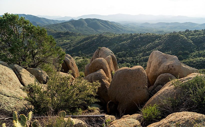
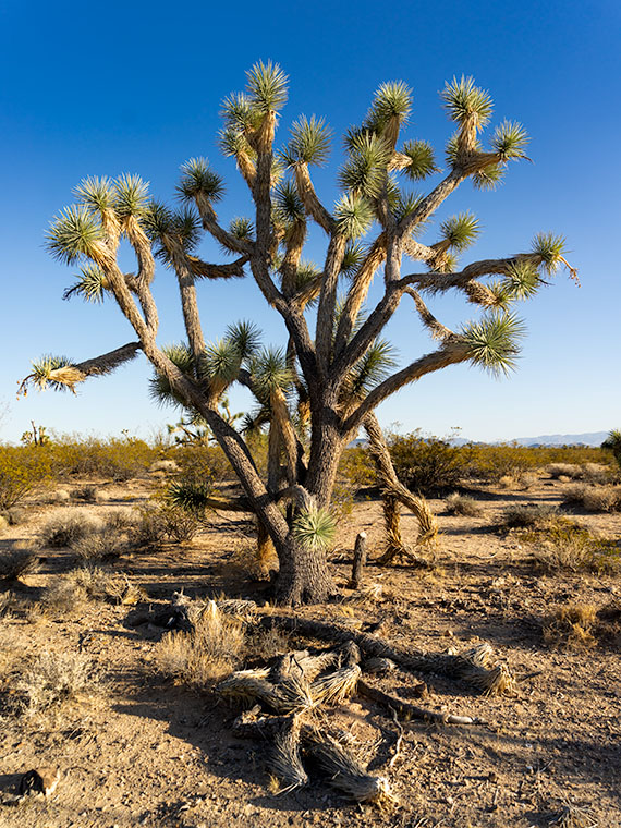
The markers confirm the obvious on some trails—like this month’s hike up the Little Granite Peak trail. The steep climb from the parking area to the first flat was like tromping through a rain gutter. Runoff and traffic have carved a trough that’s easy to follow. On the other hand, where trails traverse slick rock areas, cairns will reliably mark the easiest path. When I hiked to Coyote Gulch in Utah, there were long sections of trail where I had to stop at one of the cairns and look for the next one before I went any further. Later I found that the markers kept me from having to scramble down treacherous cliffs.

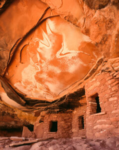
Another time that I remember cairns saving my butt was on the outing to Cedar Mesa. While Queen Anne waited in the truck, I hiked down into Cigarette Canyon to get this shot of Fallen Roof Ruin. She insisted that I leave the keys with her. After reaching the canyon bottom, I only had to trudge a mile before I spotted the ruin nesting high in the cliffs. Paying no attention to my route, I scrambled up the smooth sandstone wall with my camera and tripod.

Fallen Roof Ruin - Built high above a canyon floor, these ruins were a strenuous hike to get to, but a treacherous path down.
Fallen Roof Ruin – Built high above a canyon floor, these ruins were a strenuous hike to get to but a treacherous path down.

After getting my shot, I started my descent, but what I saw scared me. It was one of those steep hills where you could only see the first few feet before the ground plunged out of sight—like the first hill of a roller coaster. I had visions of rescuers finding my skeletal remains among the ruins because I became trapped there. Anne would surely get bored and drive off, leaving me to rot alone. But as I searched for a way down, I spotted a pile of rocks to one side, so I headed toward them. From there, I saw more cairns that made a zigzag pattern down to the bottom. Thank God I didn’t have to make Anne put down her book and get out of the truck to find me.

Five Cairns - This little cairn didn't like the way you looked at her, this little cairn didn't like the way you spoke to her, this little cairn hated the way you bumped into her, this little cairn thought you smelled, and this little cairn went "wee, wee, wee," all the way to the police station.
Five Cairns – This little cairn didn’t like the way you looked at her, this little cairn didn’t like the way you spoke to her, this little cairn hated the way you bumped into her, this little cairn thought you smelled, and this little cairn went “wee, wee, wee,” all the way to the police station.

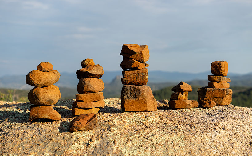
So, imagine my smile when I reached the first intersection on the Little Granite Mountain trail and saw five miniature cairns lined up on top of a boulder the size of a small Toyota. This spot must be where the fairies had a picnic. It was off the path behind some bushes, so these weren’t actual trail markers. They were left by the little people having some mischievous fun.

You can see a larger version of Five Cairns on its Web Page by clicking here. Next week, we start a new project, so come back and see where the road leads us.

Until next time — jw

Sierra Prieta Afternoon Picture of the Week

I broke down and bought one of those dorky bicycle helmets. Not the pink and white one that Anne picked out. She only liked it because it came with a Hello Kitty backpack, ideal for carrying my Capri Sun juice boxes. Mine’s bright silver with a black visor, and when I wear it, I look like the cartoon character in Pearls Before Swine—Jeff the Cyclist. Women swoon when I ride by.

I didn’t buy a helmet as a riding accouterment; it was a practical choice. A couple of weeks ago, I fell off my bike and landed on my head in a neighbor’s front yard. Don’t worry, nary a scratch, so I got up and finished my ride, but I was all over Amazon the minute I got home.

The bike was an innocent bystander in the crash; the real culprit was my balance. I’ve had dizzy spells recently. They’re caused by the microscopic sand particles in my inner ear balance thingy—the vestibular system. Some of the particles in my ear have escaped, and when I tilt my head, they brush hairs and set off dizzy spells—vertigo.

As I was climbing the hill on my morning route, I looked down at the chain to see which gear I was in, and when I looked back up, my head started spinning. The spells usually only last a short time, so that I thought I could power through, but the bike kept drifting toward the left curb, and I couldn’t control the steering, so I stopped to get off. If I get dizzy at home, all I need is to touch a wall for balance. There was no wall in the street. I was on my way to the ground before I knew it. I landed on my back, and I pounded the gravel with the back of my head. I sat up and checked for anything broken or bleeding. Then, I glanced around to ensure that no one had seen me before continuing my ride when I found none.

I’ve already seen my doctor, and she gave me exercises to round up those little buggers, so I’m doing better. There are a few recalcitrant grains that still run loose in my ear, but we’ll get them back in their cage eventually.

The dizziness was a concern on this month’s hike, but I wasn’t affected on the trail. I guess that the strenuous exercise kept it at bay, but I touched every boulder and tree along the way to be safe. When I reached the top, I was rewarded with views like in this week’s image.

Sierra Prieta Afternoon - From the top of Little Granite Mountain Trail you can see south all of the way to the Weaver Mountains.
Sierra Prieta Afternoon – From the top of Little Granite Mountain Trail, you can see south all of the way to the Weaver Mountains.

I call this picture Sierra Prieta Afternoon, and in it, you’re looking south from the hilltop. Beyond the eroded granite boulders, there are three mountain ranges. The closest peaks—the ones with color—are the Sierra Prieta. The next range—the one that has the large rounded peak—is the mountains around Kirkland and Skull Valley. Finally, along the horizon on the left-center is a glimpse of the Weavers. Our home is down on the desert floor on their far side—four thousand feet below the point I was standing.

You can see a larger version of Sierra Prieta Afternoon on its Web Page by clicking here. Next week, I’ll finish with a whimsical thing I found on the Little Granite Mountain Trail, so be sure to come back.

Until next time — jw

Prescott Basin Picture of the Week

There’s a growing trend in the comedy routines that Queen Anne and I watch on YouTube’s Dry Bar channel. The bits poke fun at young people for not knowing about obsolete things my generation regularly used. I’m not sure if the joke is at the youth’s expense or if it’s simply us old farts complaining about change again.

To give you an example, one performer asked a teen in the audience to explain the relationship between a pencil and a cassette tape (the kid didn’t know what the tape was). Another was about the phone books we used to get each year. The fact that we had to look numbers up on our own was mind-boggling enough, but they couldn’t comprehend that the books were primarily used at grandma’s house as a booster seat. Finally, hold up a 10’ curly phone cord and ask a young person why it existed.

I uncovered another lost phone tradition this week after talking to a particularly annoying salesman. It’s known as the old 40mph-hangup. I learned it from my dad back in the age of unenlightenment. It has Zen-like qualities and resembles a marshal-arts move, but it more closely mimics the grace of a baseball pitch. I’ll try my best to describe it. After you’ve had your fill with the person at the other end of the line, you scream a final taunt—after all, you must have the last word—then as you lift your left leg, you begin to swing your right arm in a full roundhouse motion and slam the handset onto the cradle. It should bounce at least once. I saw my father shatter an old black Bakelite phone we were renting from Ma Bell. Although this hang-up never accomplished anything productive, it always put a satisfying exclamation point on your lunacy.

With remote handsets these days, they took away that small joy of life. No matter how hard you mash the End button, it’s silent. Your adversary doesn’t know if you hung up or the phone dropped the connection. I don’t own a smartphone, but vigorously swiping at the screen can’t be any better. Maybe someone could write an app that plays a recording of a loud car crash before disconnecting. That would come close. Kids don’t know what they’re missing.

Now we have to find another channel to drain all that excess adrenalin. I could have run up and down the Little Granite Mountain Trail a couple of times with that pent-up anger. I wouldn’t have even broken into a sweat by the time I reached upper flats. Instead, I had to stop constantly until the pounding in my ears subsided.

Prescott Basin - You can see miles in any direction from the flats on the Little Granite Mountain Trail, like this view of Prescott to the east.
Prescott Basin – You can see miles in any direction from the flats on the Little Granite Mountain Trail, like this view of Prescott to the east.

It was at one of those rest stops that I got this week’s featured image. Close to the trail’s top, it begins to flatten, and you can finally see above the trees. After I passed this Alligator Juniper, I stopped for a rest. Here, I could see Prescott in the distance below, so I couldn’t resist snapping a photo. The view was hazy from the humidity, so I’m sure it would be spectacular on a clear winter afternoon. I call this photo Prescott Basin. I hope you enjoy seeing it.

You can see a larger version of Prescott Basin on its Web Page by clicking here. Next week, we’ll walk around and take in more views from the top of the trail, so I hope to see you then.

Until next time — jw

Prickly Pear Fruit Picture of the Week

For September, I’m going to bring you something out of the ordinary. We’re going to put the clouds behind us, pull off the road, and get out of the truck. We’re going to go for a short walk down a path—well, it’s more like a hike up a steep trail. I survived, so you’ll be fine. I promise you’ll be fine.

The subject that I originally had in mind for this month was the Sierra Prieta Range. The name is Spanish and means Cold Mountains. They are an offshoot of the Bradshaws. If we went to the top of Prescott’s tallest building and faced west, you’d be looking at the Sierra Prieta. Then if we turned south, the mountains that we stared at would be the Bradshaws. The best-known icons of the Sierra Prieta are Granite Mountain, Little Granite Mountain, and Thumb Butte.

So, when the rains finally broke late this week, I hopped in Archie and drove up to the Little Granite Mountain trailhead. All I intended to do was get above the treetops and photograph some of the mountain peaks. However, the surrounding chaparral was so dense that I wound up where my trail intersects with the Clark Spring Trail—a mile and a half further and four hundred feet higher than I intended. The good news is that I frequently had to stop and rest, and when I did, I was able to shoot some pretty things around me. When I returned to my computer that evening, I changed my month-long project from an entire mountain range to a single trail—well, the first third of it.

Prickly Pear Fruit - A prickly pear growing in the shade of an alligator juniper in the Sierra Prieta Mountains.
Prickly Pear Fruit – A prickly pear growing in the shade of an alligator juniper in the Sierra Prieta Mountains.

The underbrush along the trail is a transitional zone. It’s where Sonoran Desert plants intermingle with those found in our mountains. This week’s contribution is an example. In the photo that I call Prickly Pear Fruit, a common cactus is growing in the shade of an Alligator Juniper. Y’all should know by now that I’m fond of subjects in dappled light, and that’s what drove me to my knees to get this shot.

I like the soft pastel colors of this plant and the complementary color of its ripening fruit against a background of deeper green ground ferns (or whatever they are). I guess the purple is the prickly pear’s way of saying, “Here, eat this part,” to javelina. They eat it like candy. But, the piggies disperse the seeds in their scat, so both parties benefit from the exchange.

As an aside, the fruit makes a great jam that is getting harder to find. It’s sweet and spicy, and I like that taste combination. Because it’s not widely sold, only local kitchens produce it. Our health inspectors have been shutting down the mom-and-pop shops because they don’t have extensive stainless steel production lines like big food producers. So—like moonshine these days—you have to know someone who knows someone—or roll your own.

You can see a larger version of Prickly Pear Fruit on its Web Page by clicking here. Next week, we’ll take a few more steps up the trail until I’m out of breath again, and you’ll see what I found while I rested.

Until next time — jw

Cirrus Streak Picture of the Week

My favorite landscape photographers have different styles of working with a horizon. There’s a group that omits the sky from their images. Charles Cramer, for example, most often leaves the sky out of his pictures. Michael Kenna and Ansel Adams use the skyline as part of their image’s graphic design. On the other hand, Mitch Dobrowner’s images are mostly sky and extreme weather. (To be honest, if I ever had an opportunity to go on one of Mitch’s shoots, I’d take lots of underwear because I’d be scared.)

I can’t think of a master photographer that exclusively shoots sky. I don’t know why. Perhaps it’s the lack of context. Clouds around the world are the same. Without a ground-based reference point, you can’t tell where or when I took the photo, and there’s no sense of scale because clouds come in all sizes.

Cirrus Streak - A wispy streak of cirrus clouds thousands of feet above monsoon cumulus clouds forming above the mountain tops.
Cirrus Streak – A wispy streak of cirrus clouds thousands of feet above monsoon cumulus clouds forming above the mountain tops.

My picture of the week, for example, could have been taken in Tibet, at the Grand Canyon, or even in your backyard. It’s not obvious what year, season, or time of day it was taken. It’s essentially a monochrome image that would work as well if it were black and white; only the subtle color in the cumulus clouds hint of the hour.

The story of this week’s image—that I call Cirrus Streak—is that this is another of my August Monsoon Clouds project. In my quest to hunt down and capture images for the project, I drove a back road through the valley between the Weaver and Date Creek mountain ranges. As I said last week, the Weaver’s (along with the Bradshaw Mountains) are a breeding ground for our evening storms.

As I drove, I noticed this streaky cirrus cloud thousands of feet above a cluster of cumulus clouds building low over the mountains. I’m partial to how the high wispy clouds get distorted into interesting shapes from the winds aloft. So, I stopped the truck and framed these clouds as a graphic design. If you’re disoriented, the blue sky gives you a clue. The color always gets lighter towards the horizon, so the mountains appear under the frame’s bottom.

You can see a larger version of Cirrus Streak on its Web Page by clicking here. Be sure to come back next week to see another image from my cloud hunt grab bag.

Until next time — jw

Burro Creek Bridge Picture of the Week

I had been asleep for an hour when Queen Anne finally came to bed last night. She nudged me until I almost woke and snapped, “What?”

“It’s raining,” she gleefully said.

I rolled over, pulled the covers up, and tried to go back to sleep while grunting, “Harrumph.”

“It’s pouring,” she persisted.

“Why are you waking me?”

“You’re snoring,”

I was too sleepy to recall accurately what happened next, but I think she bumped her head because she went to bed and didn’t get up till morning. I swear that’s the actual conversation we had last night.

This year’s monsoon season is unlike the drought that we had last year. We’ve been enjoying a week of cloudy skies, isolated showers, and last night’s low was under 70°. It wasn’t that pleasant autumn-like 68° where you can throw open the doors and windows. It was 68° with 95% humidity—which is cool only if you have gobs of air blowing at you—aka swamp cooler. But still, we have a decent river flowing down the street out front and the Red Sea in our backyard. The two trellis vines out front that have spent last year imitating Paul Rubin’s death scene in Buffy the Vampire Slayer—are already sprouting fresh green shoots.

All in all, it’s been a good monsoon so far, and they say there’s more to come. I lament the wasted rainwater flowing down the streets. There should be a way to capture some of it and store it for a (forgive me) non-rainy day. The runoff flows down the washes and eventually into the Gila River, where the Gila Bend and Yuma farmers use it for their crops.

I’ll bet if I revisited Burro Creek—last week’s featured image—it would look like a proper creek instead of a string of puddles. I’m not going to risk a possibility of getting caught in a flash flood. Arizona has a Stupid Driver law now, and with my luck, I’d be the first person to get billed for my rescue. Instead—as I promised last week—I’ll turn the camera around so that you can see what’s downstream.

Burro Creek Bridges - A pair of future freeway bridges cross Burro Creek before Greenwood Peak.
Burro Creek Bridges – A pair of future freeway bridges cross Burro Creek before Greenwood Peak.

The subject of this week’s image is a pair of freeway bridges over Burro Creek, waiting for Interstate 11. Don’t be fooled into believing that this is an empty highway. U.S. 93 is normally a bustling traffic corridor. It’s just that my image was taken just after dinner when the freight drivers are still belching in truck stops.

You can see a couple of other things in the photo and another hidden by the bridge. First—under the bridge—are the deep pools in the creek. They’re wet all year round, so they have small fish in them. The minnows are useless to anglers, but they support a colony of Great Blue Herron that nest along the canyon walls.

Along the horizon is the 4,339 foot high Greenwood Peak. I have another shot of this mountain that was featured in a January 2020 post. During that month, Anne and I drove over the pass to the mountain’s left and, at the bottom, we found the road blocked by water flowing in the Big Sandy River. In that article, we remarked how the slopes of the Poachie Range were covered with saguaro and pinion pines growing next to one another.

Finally, what’s hidden behind the bridges is the Burro Creek Campground. It’s smallish with quiet camping spots until a loaded semi drives over the bridge’s expansion strips—the noise echoes along the canyon walls like Gilbert Godfrey with a megaphone. However, if you’re into history, the campground’s access road is the original two-lane highway that winds its way down the canyon, crosses the creek on a  low bridge, and then ascends the north face.

You can see a larger version of Burro Creek Bridge on its Web Page by clicking here. I have to come up with a creative idea for August, so please come back and see what I’ve come up with. For now, I’m going to don my galoshes and go stomp in some puddles.

Until next time — jw

Summer Joshua Picture of the Week

Nature diligently gives us clues about seasonal changes. When it comes to summer’s onset, I tolerate most of them. There’s a specific one that I’d be happy to skip. It’s the seasonal appearance of our first rattlesnake. When we moved into our little shack in Congress, our neighbors said that they rarely see one—maybe one shows up in the subdivision. However, we personally are averaging close to one a year. Since we spent our first summer in Alaska, there’s no telling how many slithered through the yard while we were gone, so we don’t know how many we missed in 2016.

This one—Sid, as Anne called it for some reason—showed up Thursday morning—our dump day. We always look forward to Thursdays because it’s our day out on the town. We gather our weekly trash and recycle and take it up to the dump. After that, we’ll swing by Nichol’s West for our usual eggs Benedict breakfast.

This week—while Anne prepared herself for the public—I emptied all the bins and boxes then loaded them into Archie. When she was finally ready, we opened the back door, and there Sid greeted us like a Jehovah’s Witness with a sack full of Watchtower magazines. Mind you; I had already been through that door a half dozen times. I have no idea the direction from which he came, but he seemed to enjoy sunbathing on the back-door mat.

I won’t bore you with an account of the ensuing battle because it went down pretty much like last year’s encounter, but I learned a couple of lessons that morning. The first is that there’s still a gap in the decking that I need to plug. The other thing I learned from our stare-down was more important. That little varmint struck at me a couple of times, and I had time to pay attention to his rattles. They’re softer than I expected, and they’re the same pitch as my tinnitus. That means that when I’m out stomping around the desert, I have to be vigilant about spotting them first because I’m deaf to their warning sound. Of course, the only time I’ve ever spotted a rattler; it’s been in our backyard.

Summer Joshua - Joshua trees shed unnecessary leaves to help get through the hot summers in the desert.
Summer Joshua – Joshua trees shed unnecessary leaves to help get through the hot summers in the desert.

There were no snakes around when I shot this week’s featured image called Summer Joshua. On our journey north on U.S. 93, the next landmark that I wanted to show you was the large area of Joshua Trees. Because so many grow along this section, it’s called Joshua Tree Parkway. It’s a north-facing 13 mile downhill slope on which the giant lilies thrive.

The Joshua is dense along this part of the road, so when I found this isolated specimen, I stopped and asked if it would sit for a portrait. Even with the fallen limbs in the foreground, this is a healthy plant, and you can see one of its heat survival secrets. Actually, you can’t because the secret is the sparse foliage. Like most Sonoran Desert plants, the tree only has the minimum amount of leaves to keep it alive. That strategy cuts down on water evaporation, a scarce commodity around these parts. The old dry foliage folds and covers the branches, which helps cool the plant the same way people use parasols for shade. Cool being relative, because when I shot this image, the air temperature was 105° even though the time was after 5:00 pm.

You can see a larger version of Summer Joshua on its Web Page by clicking here. Next week, we’ll continue north and find another landmark along US 93, so ya’ll come back now—eh?

Until next time — jw