My sweetie loves me! Incredible, I know. After living together for over 32 years, this morning, on Valentine’s Day, she asked me what I would like for a romantic dinner. The question took me by surprise. I had to think about it. I puzzled about which meals nurtured the minds and souls of great artists. What’s the most romantic place I can think of? Then it hit me—Giverny, France of course—home of Claude Monet. So I looked up the restaurant menu from Hotel Baudy—a scene in several of his paintings and where he gathered with many of his Impressionist cronies.
I Google translated each menu item looking for something manly and not cheesy. Halfway down the list, the obvious choice jumped off the page. It has three of the world’s best things you can put in your mouth in one dish: Magret de canard poêlé aux cerises et sauce au porto—seared duck breast in a cherry-port sauce. Ah—I slobbered all over my keyboard, thinking about it.
I rushed into the living room where Queen Anne was reading the Sunday paper dressed in her threadbare robe, fuzzy slippers, and rollers. I blurted out my dinner choice. I guessed wrong. She explained that what she meant was, “Which of the packages in the freezer do you want me to microwave for you—and you can’t have the one that I picked.” <Sigh> So, I picked the other TV dinner. Ain’t love grand?
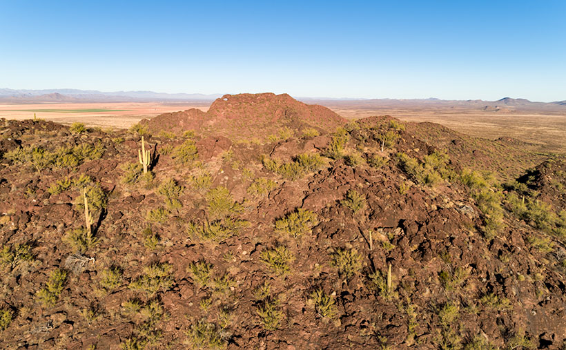
Eagle Eye East – The view from the top of Eagle Eye Mountain looking east towards the arch on Eagle Eye Peak in Aguila, Arizona.
Letting my romance wilt on the vine, let’s talk about this week’s featured image. As I promised last week, I wanted to show you the Eagle Eye Arch from another angle. In this image—that I call Eagle Eye East—we’re looking at the arch from the south side of the mountains in Aguila. I shot this picture from the top of Eagle Eye Mountain facing Eagle Eye Peak, and that’s why the arch seems more distant than last week’s photo. Since this was the sunny side of the mountains, it better shows how rough the lava surface is. I like how the bright green saguaro and palo verde contrast with the reddish-brown rocks.
Another interesting thing in this image—to me—is the background mountains. The Forepaugh Range is on the right and beyond them is the town of Wickenburg. Beyond the Aguila Valley, the tall mountains on the left horizon are the Weavers, and that’s where we call home.
You can see a larger version of Eagle Eye East on its Web Page by clicking here. Be sure to come back next week, and I’ll show you the final shot that I liked from my outing in Aguila.
The last time I wrote about Aquila’s Eagle Eye was in 2018, and I didn’t have much to say about it—other than it was there. That post included a photo I shot with a telephoto lens from miles away. I had to do that because much of the land around the peak is posted as private. There were two comments in that column. The first was from Fred, who thanked me for pointing the bridge to him, and the second was from my old friend Gary, who chastised me for not getting closer.
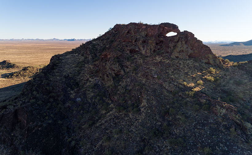
Since I’ve been hanging around Aguila this month anyway, I thought I’d try to make Gary happy. About three miles south of Aguila are mountains on the east flank of the Harquahala range. They almost have the same name; Eagle Eye Mountain is on the west, while Eagle Eye Peak is the lump of lava to the east (they touch one another). The latter peak is the one with the window on top.
Eagle Eye Peak – A natural arch on top of a peak several miles south of Aguila, Arizona. Behind Eagle Eye is the Harquahala Plain, which stretches south to the Big Horn Range on the horizon.
You can get very close to the arch if you drive to the old cemetery where Eagle Eye Road bends around the mountains. The bad news is that you can’t see the arch from there because it faces east, and all you see are the rocks from the edge. There’s a better view if you scramble up an 800′ cactus-infested lava hill like an insane person, but I did the lazy thing. I brought my drone, and I flew it to the mountaintop. Once it got up there, I rotated it to the right and composed this shot.
The Eagle Eyes, like a lot of low desert mountains, were formed from volcanic activity. This particular pair of mountains is basalt-covered limestone. The rocks are much darker than the rest of the Harquahala Range. They appear as shadows on the horizon. Their surface is rough and pockmarked, like they had a bad case of acne. They are riddled with caves formed by air pockets in the lava.
I didn’t find an article that explains how this arch was formed. I don’t think it was formed from wind erosion. The rocks aren’t polished. It could be from one of those air voids in the thin-walled lava collapsing. My favorite guess is this: If this is Rhyolite—slow-moving lava common to peak formation—then maybe a cone of lava formed vertically, and as it cooled, it slumped over and froze in place. At least, that’s what it looks like to me. What do you think?
Well, Gary, I hope you’re happy. Click here to see a larger version of Eagle Eye Peak on its Web Page. Be sure to return next week when I’ll show you the arch from a different perspective.
Our little town is not so different from yours. We have crime here too. That’s why the county sends a couple of deputies down from Prescott to patrol our streets and keep us safe. Most of the time, they drive around the empty streets, but there are moments where a rush of adrenalin flows through their veins—like last Friday night.
As most cops do, deputies Starsky and Hutch parked their cruisers on the dead-end street between the Dollar Store and the Quickie-Mart in such a way that they could drink coffee, chat across their door windows while keeping an eye on the only traffic control sign in southern Yavapai County. The night had been rainy but peaceful up till then.
Shortly after Congress’s only cowboy gay-bar closed, a pair of suspicious cars rolled up to the stop sign before turning south on Highway 89. Starsky noticed that a woman with long blond hair was driving the lead exotic Italian sports car (Around these parts, a Fiat 500 stretch limo is considered exotic) in the din of the sodium-vapor street lights. “I have to check this out,” Starsky yelled out his window, stowed the coffee in a cup-holder, put his cruiser in gear, and drove off in chase.
As he perused the little import through downtown Congress, he crossed over the double yellow lines, raced around the second vehicle before cutting in front of it. Then he lit up his lights and pulled the Fiat over. As he called in the plates for wants-and-warrants, he noticed that the sinister black Buick had pulled in behind. Sensing a threat, he radioed Hutch for back up. When he finally saw the second set of emergency lights in his mirror, he felt that he could safely get out of his cruiser.
Hutch had already climbed out of his truck behind him with a Maglite in his left hand while resting his right hand on his holster. He walked up to the second suspect’s vehicle and heard the last remaining Jennifer Rush Disco CD blaring through the stereo. The woman behind the wheel sat motionless with her hands in the air. “Mam, can you tell me why you pulled off the road behind my partner?” (OK, to protect the innocent, I have to change some names. Donna is the floozy driving the Fiat because Donnas always drive convertible sports cars. The gangsta-girl in the second car I’ll call Princess Margaret. Yeah, that works. No one will ever guess their real names.)
“That’s my friend, Donna,” Margaret replies. “I just want to make sure she gets home alright.”
“Well, this is a dangerous place to park. You’ll be safer if you pull in front of the other vehicles.”
With that, Margaret put her hands down, put on the left blinker to signal the empty highway that she was pulling out. Slowly she drove around the other cars, signaled that she was pulling back off the road, she put the car into park, and—once again—raised her hands over her head.
As Starsky strutted toward the hottie in the little white Italian Job, he practiced his best, “So, how you doin?” But when he got to her open window, the flashlight glare revealed far more lines of wisdom on her face than he expected, and her long tresses weren’t blond; they were pewter. His training and quick thinking let him instantly change tact. Instead, he asked, “Do you know why I pulled you over?”
“No, I don’t.”
“You didn’t come to a complete stop at the sign on 71.”
“Yes. I believe that I did.”
“That’s OK; I’m going to let you off with a warning,” which is what cops do when they can’t prove something in court. It also leaves a paper trail that shows they were working.
Donna—the consummate socialite—tried to get on the deputy’s good side, “I understand. My first husband was a Highway Patrol Officer.”
“When was that,” Starsky asked.
“During the late sixties and seventies,” she replied.
“That was long before I was born,” he gasped.
After Starsky filled out the form, he handed it to Donna and watched her drive off. Margaret finally put her hands down and followed into the darkness. As he walked back to his Tahoe, it finally sunk in that he almost hit on his grandma; he doubled over and blew donut chunks onto the front tire. From the other cruiser, he could hear Hutch’s giggling float across the damp night air.
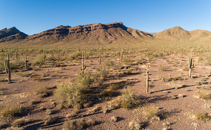
Harcuvar Forest – A large grove of Saguaro grows along the eastern flank of the Harcuvar Mountain Range.
You may be wondering what this story has to do with this week’s picture. Well, actually, nothing other than our town’s stop sign is on Highway 71, and at the other end of that road—near Aguila—is where Santa rests, and there is a large grove of saguaros growing along the eastern flank of the Harcuvar Mountains. That’s where I took this week’s picture, which I call Harcuvar Forest. When I drove home from that shooting, I stopped at that very intersection—without getting arrested. I guess that I’m not cute enough.
You can see a larger version of Harcuvar Forest on its Web Page by clicking here. Next week, I’ll bring you another image from around our house.
After five years of retirement, I realize I slowly get things done by putzing. As I grow older, I don’t have a young person’s stamina, so I limit how much time I work in my shop or office. I am organized about it. I have certain days that I do things. There’s wood-Monday where I work in the shop; music is when I manage my music catalog; web- Saturday is when I update my website; and today—blog- Sunday—I write my posts. Each week’s highlight is dump-Thursday when Queen Anne rewards me for taking out the trash by treating me to Eggs Benedict at Nichols.
The remaining days are our weekend. Like the rest of America, we go shopping, on photo outings, visit our ever-growing list of doctors, and do chores around the house—if I must. I can also appropriate these days if I need more time for another priority. So, I’ve organized my interests into neat little day-packets. That way, I get to play with all of my toys. That’s important because if I don’t use them, Anne has threatened to haul them off to Goodwill. My system keeps me busy, yet there’s plenty of time for naps.
Imagine how frustrated I get when a week—like this one—comes along and upsets my routine. With this month’s I-10 project, I must go out each week to get a new shot. I planned to go out on Tuesday, but afternoon clouds moved in. Wednesday, it rained, so I swapped it with music Friday because Anne wasn’t here to gripe. The clouds remained on Thursday, but that didn’t stop me from going to the dump and buying my breakfast (there was hell to pay when the restaurant staff wanted to know what I’d done to Anne). Friday was still dull and gray, and I’d already done music Friday on Tuesday, so I had to sit on my hands. I needed a picture for Saturday’s update.
Yesterday, I set the alarm for 5:00 a.m. and drove down to Courthouse Rock in the dark. I repeated a mantra as I went, “Please let there be good light. Please let there be good light.” When I arrived, I was rewarded with high clouds, but the eastern horizon was clear. I only had about an hour to shoot as clouds were already gathering. This is the shot that I liked the best; I call it Courthouse Rock.
Courthouse Rock – Located in the northeast corner of the Eagletail Mountains Wilderness Area, the Courthouse attracts rock climbers across the globe.
The rock is the northeast corner of the Eagletail Mountains Wilderness west of Tonopah. You can see it on the south side of Interstate 10, less than a half-hour drive from the truck stop. If you take the dirt roads—as I did—the time doubles. The road in the lower right section of the photo gets closer, but I was running out of the golden light. I was still a mile away from the rock when I took this photo.
Courthouse Rock is well known to rock climbers, so it gets a lot of worldly visitors. As I left, at least a half-dozen SUVs loaded with people were on their way to the Courthouse. The vertical wall that looks like a curl from a Dairy Queen machine presents a challenge similar to Yosemite’s El Capitan. Besides the height, the most remarkable difference is that California’s is granite (lava that cools slowly underground). At the same time, ours is Rhyolite (thick air-cooled lava squirted out of an ice cream machine).
You can see a larger version of Courthouse Rock on its Web Page by clicking here. Next week, I’ll present another of my favorite I-10 landmarks. Because it’s sunny and clear today, I’m going out to shoot it this afternoon—none of this last-minute panic for me. Of course, it will have to wait until after my nap.
We’re down to the final month of this gawd awful year. For one, I will be happy to get my vaccination and venture back out into the world again—well, right after you get yours, and I see that you don’t get sick and die from it. I’m afraid that it’ll be months before it’s my turn because I’m too young and pretty. So, because it’s a short month, and Queen Anne has abandoned me, we’re going to explore a road that’s both close by but too expansive to cover in one day.
This month’s focus will be on a road, unlike what we’ve covered on this platform before. It’s not even dirt. It’s a road that stretches from Jacksonville, Florida to Santa Monica, California. It’s also the longest possible way to cross Texas. When Anne and I visited Deb and Fred in Austin several years ago, I was dismayed to see a highway sign that said our destination was further off than the two states through which we’d already driven. I’m, of course, talking about Interstate 10.
Calm down, we’re not going to do the whole thing in one month, and I’m not ready for a lifetime commitment (ask Anne). For December, we’re going to point out the landmarks that I enjoy seeing between Phoenix and the Colorado River. Even with that limitation, there are too many to fit into four Sundays. We’re not even heading in a particular direction; we’ll talk about each place as I get to it.
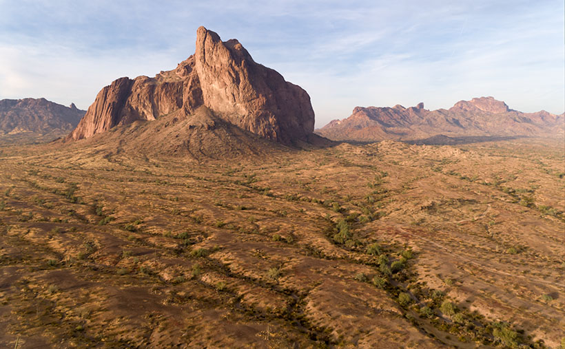
If you’re like me, you loath driving cross country on the Interstates, but they are the most efficient route when your time is limited. I’ve made countless trips between Los Angeles and Phoenix since moving here a half-century ago, and the flat desert always was the worst grind—river, flat, mountain, flat, mountain, flat, town. After I learned some about the mountain ranges, it was more enjoyable to know that Courthouse Rock was coming up on the south side or that I could spot the abandoned solar observatory on top of Harquahala Mountain. It was like saying, “Hi” to old friends as we passed.
This week’s featured image was taken in the Tonopah area. From east to west, you’ll pass the Palo Verde Nuclear Generating Station, stop at Tonopah Joe’s for gas and heartburn, then on the north side of the highway—where Salome Road crosses—there’s a prominent horn mountain, called Big Horn Mountain. It’s the centerpiece of a wilderness area that’s the same name. Actually, there are two wilderness areas separated by a dirt road that I’ve yet to discover. These are the Big Horn Mountains Wilderness and the Hummingbird Springs Wilderness across the street. You can do backflips across the road from one to the other.
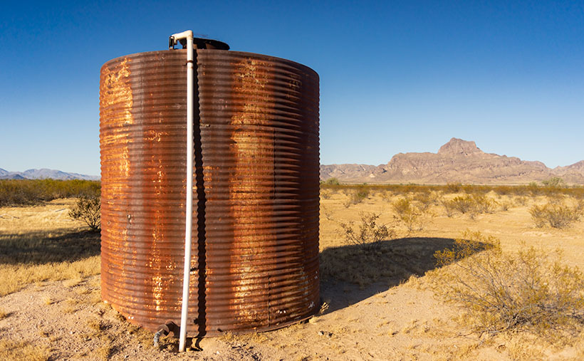
Big Horn Tank – On the plains south of Big Horn Mountain Wilderness Area is a rusty tank meant to provide water to cattle on the open range.
This week’s featured image that I called Big Horn Tank was taken from the Harquahala Plain off of the Salome Road. There on the open range, I found a rusty water tank for an interesting foreground. I think that rust is a photographer’s favorite color, and I like how the white PVC pipe accents the tank. The other thing I see is how little vegetation cattle have for grazing. They don’t eat creosote (would you), so they only munch on the yellow grass.
You can see a larger version of Big Horn Tank on its Web Page by clicking here. Be sure to come back next week for another roadside landmark from Interstate 10. Tomorrow, I have to phone the Queen to see where I’m allowed to go. Wait till I tell her what happened to me as I was leaving Algodones yesterday—she’ll never let me out of the house again.
When you hear someone talk about a desert, what image pops into your mind? Is it the endless Sahara dunes where Bedouins in keffiyeh headdress travel by camels? Maybe it’s the barren, dry lakes of Death Valley, or perhaps your go-to desert is in Mongolia. By definition, a desert is any place receiving less than 20 inches of annual precipitation. That makes most of the Great Plains, most of Southern California, and the Antarctic deserts.
My desert is the one that I’ve called home for almost 50 years; the Sonoran Desert. In the last half-century, I’ve traveled most of its parts within Arizona and California. I can attest that it’s not a flat, uniform wasteland—as some people think. It has mountains, canyons, plains, dry washes, and an exotic river or two. Its span ranges between Arizona and the Mexican State of Sonora. If you see a map of it (and you have to squint real hard), it’s jellyfish shaped—starting at the north (where I live), the half-circle body covers Arizona, and the tentacles reach south to either side of the Sea of Cortez. Its width covers from El Centro to Tucson.
The signpost that says, “This is the Sonoran Desert,” is the saguaro cactus. It thrives here because of the four major western deserts; the Sonoran is the only one with two rainy seasons; winter rains and summer monsoons. In winter, the rains nourish the cactus to flower and bloom, while the monsoons provide water for the dispersed seeds to germinate. Isn’t nature swell?
Although the saguaro may be the Sonora’s big-ticket item, it isn’t the only thing here to see. That’s evident when you visit the desert’s reserves like Saguaro National Park, Organ Pipe Cactus National Monument, KOFA Wildlife Preserve, or several wilderness areas in southern Arizona. The biodiversity of these places will keep you on your toes—“Watch out! There’s a snake over there.”
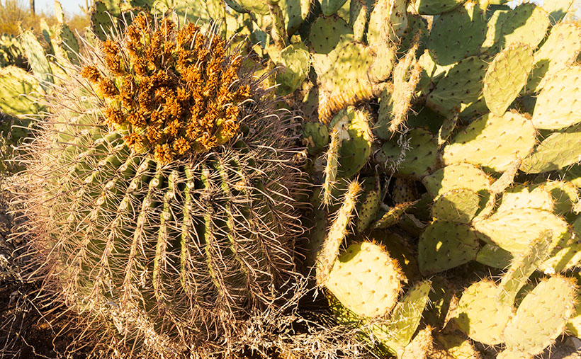
Fish-hook Barrel Cactus – a couple of succulents nuzzle in the late afternoon sun.
That’s how I thought I’d end our one-day tour of Saguaro National Park. While exploring the park’s dirt road loop, I spotted a couple of succulents nuzzling one another, so I went in and grabbed a shot. I call this picture Fish-hook Barrel Cactus. It shows a couple of common cacti—a fish-hook barrel and prickly pear—glowing in the evening sun. The barrel cactus is the one you’re supposed to cut open if you need water—it’s not hollow, so you have to wring the pulp if you’re desperate for a bad tasting drink. Prickly Pear grows everywhere and has even overrun Australia after it was illegally transplanted there.
You can see a larger version of Fish-hook on its Web Page by clicking here. For December, we have an idea for a completely different type of monthly project. We had to. I’ll be spending time with my Mexican dentist—oh joy—and Anne is risking her life to visit her family. She’s shortening my leash while she’s away, so I won’t be able to roam very far from home. If I do, my electronic collar will shock me.
I woke up in a very chipper mood this morning. When I put on my jeans, they were so loose that I had to tighten my belt a notch to make things better. My morning routine is to check my vitals before making coffee, and my blood pressure was perfect today. There’s been a great weight lifted off my shoulders, and let me tell you what I think it is. First of all, I finally finished the wood project that’s kept me busy all summer—I’ll show you on Wednesday—and secondly, summer’s finally over—well I hope it is.
Over the past couple of days, clouds have filled the Congress skies, and it sprinkled Friday evening. That’s the first precipitation in months. This morning, our new wall thermometer got below 40º for the first time, and I got to put on one of my bulky sweaters. It keeps getting better—today’s forecast is for snow in the mountains. Yep, straight from summer to winter. Today, the world is better.
My mood is so good; I don’t have any snarky stories about Queen Anne, so let’s go back down to Tucson and see where we stopped for our second November image. Last week, we visited the overlook at the top of Gates Pass before dawn. Believe it or not, I wasn’t the only photographer there. A handful of guys were hanging out with their tripods set up for a sunrise shot when I got there. I’m not usually late to one of these parties, and when I saw what they were getting ready to shoot, I wasn’t impressed—it was more of a sundown kind of shot. After snapping a few other scenes, I hopped in the truck and headed down the road stopping again at the bottom of the pass.
Tucson Mountain Sunrise – The morning sun shines on top of the Tucson Mountains.
In this week’s featured image—that I call Tucson Mountain Sunrise—we’re looking back at the overlook. It’s the flat area between the two forward peaks at the bottom of the sunlight. Behind that, you might recognize Bushmaster Peak from last week’s image. Actually, all of it is Bushmaster Peak, but I really liked the western side’s gnarly part. It has the most character. For scale, I found a couple of young saguaros and placed them in the foreground—that means that I was wandering around in the dark, rocky, snake-infested desert to get this shot just for you.
How could you ruin a beautifully quiet moment like this? Well, let me tell you how. Just as I finished my shot and began walking back to R-chee, a guy who was parked nearby in a black late-model Chevy pick-up fired it up, and the distinct sound of a V8 with open headers reverberated throughout the canyon. Now, I enjoy loud race cars as much as anybody, but it has to be in the right context. As this gentleman drove east through the pass, it was obvious that he wasn’t racing—he was making noise just for the sake of noise. Fortunately, after the summit, he rode the brakes downhill, and the bird songs once again filled the morning air.
You can see a larger version of Tucson Mountain Sunrise on its Web Page by clicking here. Next week, we’ll make a morning stop in Saguaro National Park for another photograph in our story.