Camp Wood Boulders Picture of the Week

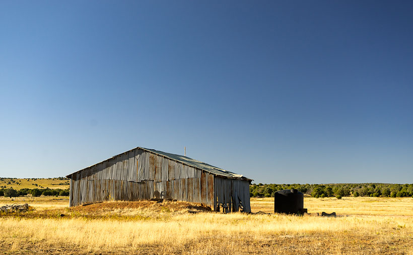
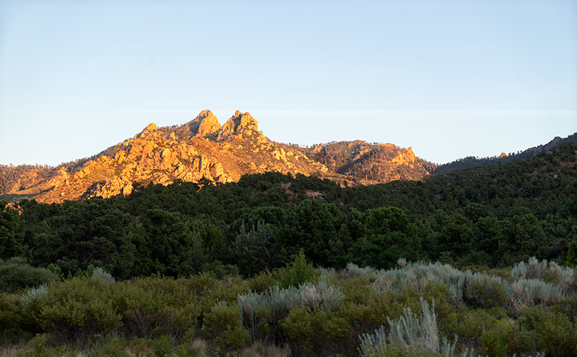
After stopping to photograph the shed featured last week, Queen Anne and I continued our journey along the Camp Wood Route. From the building and corals, the road is better graded, so we were able to pick up the pace, and we soon reached the edge of a canyon called Connell Gulch. On the far side of the canyon are the 6400′ Connell Mountains rising from the east bank of a creek below.

From the canyon’s edge, the road descends northward, and at the bottom, the landscape flattens and opens into grassy pastures filled with cattle. It was only another mile or two before we passed the headquarters of the Yolo Ranch—a sprawling 110-thousand-acre ranch established in 1885 by Tip Wilder. As it turns out, we had been traveling on ranch property since passing the gate I mentioned last week.

Yolo Cows - Cows stand between their calves and a perceived threat.
Yolo Cows – Cows stand between their calves and a perceived threat.

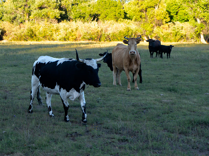
Here, we saw an idyllic valley with meadows and ponds, surrounded by ponderosa pine-covered mountains. Behind fences, there were a variety of grazing cattle. We even spotted a herd of deer, which were too skittish to let me get near and take a good photograph. Yolo is a working cattle and guest ranch, but I’m not sure they still offer accommodations. Authors have used it as a location in books, and the farm was the subject of a film documentary. In 2010, Yolo Ranch was for sale with an asking price of 12 million dollars, and I found the sales brochure online if you want to know more. It must be a peaceful place to live, but I’ll bet the TV reception is lousy.

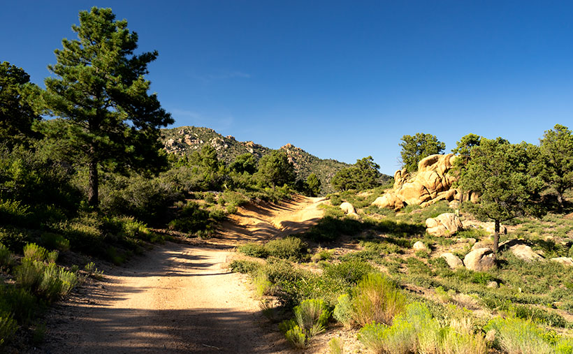
Back on the road, reaching Camp Wood didn’t take long. It was only a short distance on the tree-lined trail. This area was initially called Kymo by Paul Wright. According to Arizona Place Names, he was from Kentucky, while his wife was from Missouri. A decade later, the U.S. Cavalry—led by Captain Wood—camped here on a scouting expedition, and the postal service chose Camp Wood for the post office in 1926.

I had a good feeling about this area. I thought that it would make a good campsite in milder weather. The elevation is 5800′, so the temperature would be excellent in spring and fall. Having a cup of coffee in the chilly mornings is always a good thing. There aren’t any facilities, water, or electricity, but that’s roughing it.

Yolo Cows - Cows stand between their calves and a perceived threat.
Camp Wood Boulders – In the late afternoon sun, granite boulders glow against a clear blue sky.

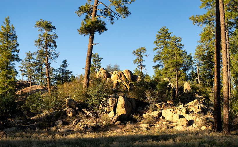
When we got to the Camp Wood area, the sunlight already had a lovely golden glow, and off the road a distance, it highlighted a mound of granite. I hiked to them and captured the moment in this week’s featured image, Camp Wood Boulders. I like how the afternoon light highlights granite before a clear blue sky. I’m also happy with the red-barked ponderosa frame in the scene.

Click here to see a larger version of Camp Wood Boulders on its Web Page. I hope you enjoy viewing it. Next week, we’ll make another stop along Camp Wood Road for an entirely different scene. I hope you’ll join us.

Until next time — jw

Tin Shed Picture of the Week

It was the fourth article about my time shooting pictures in Colorado’s San Juan Mountains when Queen Anne burst into my office—all akimbo—and began scolding me. “Fred and me this, and Fred and me that. I haven’t had press in a month.” I felt like the guy in that Toyota commercial trying to answer his wife’s question. “I’m sure there’s a right answer here.” I quickly flipped through my brain’s Rolodex of apology cards, before I realized she was right. I had to change tactics, “If you want press, you have to put your butt in the truck.” I had her.

Last week, I announced that I was leaving for one of my back-road photoshoots, and I wouldn’t be back until after dark. I packed my gear and went into the house to grab my cooler stuffed with water and snacks. When I got back to the garage and jumped into Archie’s driver’s seat, guess who was sitting shotgun? Yes—it was Her Highness.

Now that her ego is satiated, I can tell you about October’s topic. I picked out a back-road that goes from Bagdad to Williamson Valley—northwest of Prescott. On my Gazetteer map, it’s identified as Behm Mesa Road, but it had several other names as we drove it, like Camp Wood Road, Forest Service 21, or Yavapai County Route 68. The map says it’s broad and well-graded, so a passenger car should make it, but there are sections on Behm Mesa’s shoulder that are rough and rutted, so I’d feel more comfortable driving at least a pickup truck with some ground clearance.

The terrain starts in Bagdad with large boulder fields interspersed with grassy flats on the mesa tops. As the trail gains elevation, the trees change from scrub oak to juniper and ponderosa pine near the Santa Maria Mountains.  After that, the road descends into the open grasslands found around Prescott. There are a couple of cattle gates that you have to open (and close) as you cross private ranches. Most of the route’s middle section runs through the Prescott National Forest, including a part along the edge of last Augusts’ Sheridan Fire. It’s weird/unusual to see a healthy forest on the road’s north side while the south side is black and barren.

Tin Shed - An old corrugated tool shed along the Camp Wood Road.
Tin Shed – An old corrugated tool shed seen along the Camp Wood Road.

I took this week’s featured image near our starting point. As the road leaves Bagdad, you slowly travel on the shoulder of Behm Mesa—where the rough part is. September’s heavy rains may have been the cause of the ruts, and the county hasn’t regraded it. Shortly after it makes its way to the mesa’s top, you reach the first gate at a ranch house, with black cattle hanging around a water tank. Just past the tank was this tin shed in a golden grass field that had a nice contrast against the deep blue sky (opposites on the color wheel). You all know that old buildings—like this one—are a favorite subject of mine, so I had to get out and snap a picture. I call it Tin Shed.

You can see a larger version of Tin Shed on its Web Page by clicking here. I hope you enjoy viewing it. Next week, we’ll have another image to show from the drive that Queen Anne (she gets make-up press) took on the Camp Wood road.

Until next time — jw

Hualapai Road Picture of the Week

To reiterate what I said in my first post on exploring the Hualapai Mountains, there isn’t much open space there. The little village consists of a cluster of homes, a general store, and the county park for everyone else. There aren’t the amenities that you expect in Flagstaff or the White Mountain communities, but if you like camping and a challenging day hike, the park at the top of Sawmill Canyon Road is a different destination.

Hualapai Road
Hualapai Road-A dirt trail on top of the Hualapai Mountains that reminded me of the Loan Ranger’s opening scenes.

When I first arrived, I explored every road to see what’s there, but the only trail leading out of town soon became to rough and exceeded my road rules, so I turned around and headed back to the park. Before I did, I liked the rustic feeling of the country road, so I composed this week’s featured photo of the scene. I call this image Hualapai Road, although it’s little more than a trail.

The reason that I selected this photo over some others was how the trail curves over a hill between the rocks and trees. It makes me wonder where it leads, and what will I see when I get there. The countryside also reminds me of the opening scene of the old TV show The Lone Ranger that I used to watch as a kid on Saturday mornings. It’s easy for me to imagine the masked hero galloping on his white stallion over the hill—kind of like me and Archie.

You can see a larger version Hualapai Road on its Web Page by clicking here. Be sure to come back next week when we start another series of image from another location.

Until next time — jw

Potato Patch Picture of the Week

A couple of weeks ago, I talked about my struggle to climb a half-mile to an overlook on Hualapai Mountain Park’s Potato Patch Trail. Remember? Some hikers felt sorry for me and offered water while others were impressed that I was old, but still on my feet. Anyway, I’ll bet you’re wondering if there’s a picture from there. The answer is yes, and here it is.

Potato Patch
What appears to be the mountain top conceals the real summit – Hayden Peak which is another half mile away and three-hundred feet higher than these rocks.

This week’s shot is from the rocky perch looking up at a false peak. It’s one of those illusions that happen on a trail where you say, “I’m almost there.” So, you keep going, but when you get there, you find that Mother Nature has moved the finish line. The image shows rocky outcrops that are an unnamed high point on the mountain, but the real summit is Hayden Peak, which these rocks hide and the actual summit is another three hundred feet higher. Between this false summit and Hayden Peak is something called The Potato Patch, which will remain a mystery until I return or someone enlightens me, so that is the story behind this weeks image title and I’m sticking to it. I’ll bet you thought my imagination had run wild again, or that I suffered from altitude sickness.

The view facing east at the overlook was disappointing. From the ledge, you could look across Sawmill Canyon and see Dean Peak and all of its communication towers. The little village below was obscured by pine and scrub oak trees. There was also a small window between the trees where you could see Snow Peak twenty-eight miles away in the Aquarius Range on the other side of the Big Sandy Valley (U.S. 93). I didn’t even try to get that shot because it was too much of a reach for my camera lens.

You can see a larger version Potato Patch on its Web Page by clicking here. Be sure to come back next week when we’ll show one last photograph from the top of the Hualapai Mountains.

Until next time — jw

Four Ponderosa Picture of the Week

When an Arizonan talks about a pine tree, the red barked ponderosa is most likely what they’re referencing. It’s the common pine tree in Arizona. We have so many of them that our grove grows like a slash across the state’s middle, like a belt, and they continue east into New Mexico. It’s the world’s longest contiguous ponderosa forest in the U.S. Sadly, some of our brightest citizens try to burn them all down each fire season.

It’s a happy tree for me because it means that I’m in the high country when they’re around. Most likely, I’ve traveled to escape the desert heat and spend some time in the shade of the tall pines napping with a bit of fishing line tied around my toe. I have a fond memory of getting up early on a fall morning to drive up to Hawley Lake, and as the sun came up, we were on the Rim Road. The morning sunlight flickered between the tall trees, and I felt like I was driving through the Black Forest in Germany. Although I’ve driven that road hundreds of times since then, I’ve never had the same feeling.

Four Ponderosa
Four Ponderosa – Growing in a grouping that reminded me of a four-poster bed. Maybe I thought that after my long hike and I was tired (and don’t forget, tired).

During my visit to the Hualapai Range outside of Kingman, I was surprised to see ponderosa growing. In the Desert Southwest, they only grow at higher elevations. On the road, I rely on the trees to estimate my height. First, come the pinion pine at around 5,500’, then the ponderosa starts at 6,500’, and then the aspen show up at over 7,500’. The mountain island on top of the Hualapai’s probably is most likely the western edge of our grove. Only the Black Mountains are west of here, and they’re not high enough to support the big trees.

I walked by the ponderosa’s in this weeks image on my way back to Archie after a hike up the mountain. My legs were already sore, and this four-tree grouping reminded me of a four-poster bed. The spacing between them was ideal for hanging a hammock. It’s a good thing I don’t carry one because I would have spent the night, or even worse, I would have rolled over and fallen out onto the ground. That would be just my luck.

I call this week’s image Four Ponderosa, and you can see a larger version of it on its Web Page by clicking here. Be sure to come back next week when we show another photograph from the Hualapai Mountains.

Until next time — jw

Dean Peak Picture of the Week

Dean Peak
Dean Peak – One of several points in the Hualapais over 7,000′. I captured this as the sun was setting and the rest of the mountain was in shade.

There’s a Prime Video series Queen Anne, and I watched this month called Good Omens. We enjoyed it so much that we watched it a second time, and caught a lot of the subtler jokes that we missed the first time. The main characters—an angel and his demon buddy—aren’t very good at their jobs, and consequently, they screw up Armageddon. This riddle was in an episode, “How many angels can dance on the head of a pin?” It’s a trick question because as God—the voice of Frances McDormand—explains; Angels don’t dance, that’s something the devil conjured, and there’s not a substantial enough number to count them all, because demons can line-dance in the spaces between the pin’s atoms—funny stuff. When I visited this month’s photo location, I thought about the show’s riddle.

For my August pictures, I only had to walk across the street—as such. My new subject is the mountain range on the west side of the Big Sandy River and U.S. Highway 93—the Hualapai Range. They’re part of the parallel mountain ranges making the Basin and Range Domain which runs from Utah to the California Sierras. From space, these formations look like a pack of caterpillars stampeding across a sidewalk.

The Hualapai’s are a twin to last month’s Aquarius Mountains, except they are high enough—7,000 to 8,400—for pinion and ponderosa pine to grow. That means they are often snow-covered in winter. They fill the area between Wikiup and Kingman.

When my folks lived in Kingman, I heard of a park up on the mountain, but never visited, so last week I loaded Archie and drove up Sawmill Canyon Road (alas, if there was a sawmill, it’s gone now). The DW Ranch Road exit on Interstate 40 is a handy shortcut to use if you’re coming from the valley. It’s less than 10 miles from the Interstate to the County Park which is situated in a tiny valley at the top, and where Kingman residents have packed summer cabins into every available space. As I drove along the deeply rutted streets, I wondered, “How many Ford executives can camp on the top of Hualapai Peak?” In the village’s center, there is a concrete catch basin that’s called Pine Lake, but I couldn’t find public access to it, and—from its color—I’m not sure you would want access anyway. I got frustrated at having to back out of each street I tried and decided to check out the Hualapai Mountain Park and campgrounds.

After paying a day fee, I parked in the trailhead parking lot and checked out the maps. It was already after five when I started on the path to Stair Step Overlook, about a half-mile hike. I was never athletic, and I don’t claim to be in great shape today. I grew up uncoordinated, and when I was a kid, I was always the last pick for team sports. But, I regularly walk now, and my average speed is over two miles an hour. I figured a 15-minute walk at the most, so I grabbed my camera and left my water in the truck. I was wrong. It took 10 minutes—coming back down the mountain. The trail climbed four-hundred feet in that half-mile. As I hiked, I followed a group of two men and a woman who were in their early thirties and equipped with day-packs. I followed them inch-worm style; they walked out of my sight and then they’d be resting when I caught up.

When I finally got to the overlook, my new hiking friends were lounging on large granite slabs and taking in the view. As I climbed up the stairs, I looked up to see six of them before my eyes could focus again. The woman looked concerned and asked, “Do you need water?”

“No,” I replied. “I only wanted to get here and take some pictures. I’m going back down right after that.”

Then the guy with the beard drove a stake through my heart, “Man! I hope that I can be hiking up and down some mountainside when I get as old as you are.”

I did get a shot from the overlook, but I took this week’s featured image on the drive home. I call it Dean Peak because that’s what this point’s name is. When I took this shot, the sun was almost down, and the lower part of the mountain was already in the shade. I hope you enjoy viewing it.

You can see a larger version of Dean Peak on its Web Page by clicking here. Be sure to come back next week when we’ll be showing more from the Hualapai Mountains.

Until next time — jw

Clay Hills Picture of the Week

July is soon ending, and I’ll be writing about a different mountain range and its backroads next month. In a way, I’m not ready to move on. The Aquarius Range has more that I’d like to explore, and it may be a while before I get a chance to come back. I could use an extra Sunday to squeeze in another story. Oh well—a promise is a promise.

So, this week, we’ll finish up at the beginning or end—depending on your direction of travel—of the Aquarius Range, its south end. Here, there’s no sharp boundary that identifies that we’ve arrived. The mountains just taper into low hills then gently deliver you into the Burro Creek Valley at Six-Mile Crossing.

Depending on the source the Clay Hills or Hell's Half Acre
Depending on your reference these are the Clay Hills or Hell’s Half Acre as viewed from the south end of the Aquarius Range near Burro Creek Crossing.

As you descend from the higher mountains into the valley, you’ll notice a cluster of small hills with buckskin-colored cliffs for which I found two names. On the valley floor, there are Bureau of Land Management (BLM) signs saying these Clay Hills were restoration protection. On my TOPO Maps, however, they’re called Hell’s Half Acre. It amuses me that when pioneers found land that wasn’t flat and plowable, they called it Hell’s This or Devil’s That. I once had a friend who was an Ohio farm boy who told me, “… the Grand Canyon is a wasteland. You can’t grow crops there.”

I took this week’s image after I poked around the Six-Mile crossing for a while. I looked for a pretty shot of the creek running under the Cottonwood trees. The water was slow, stagnant, and choked with algae. It resembled a cesspool, so I gave it a pass, although the shade was pleasant.

As I began driving up into the mountains, I stopped to capture the scene that I call Clay Hills. It was already late morning, and the pretty light was quickly disappearing. The glare of the harsh desert sun would soon replace the warm colors. The camera is pointed west in this perspective and highway US 93 crosses Burro Creek Canyon on the far side of the cliffs. The pointy mountain eight miles in the distance is Burro Peak, so the air was pretty clear considering the recent fires near Prescott. For a cherry topping, I threw in a young saguaro with fresh buds sprouting from its top like the hairdo kids wear these days.

Click here to see a larger version of Clay Hills on its Web Page. Be sure to come back next week when we set off for another adventure exploring more Arizona back roads.

Until next time — jw