The Grotto Picture of the Week

Grotto Interior - From the outside, the Grotto looks like a secluded place to hide from the world.
Grotto Interior – The Grotto looks like a secluded place to hide.

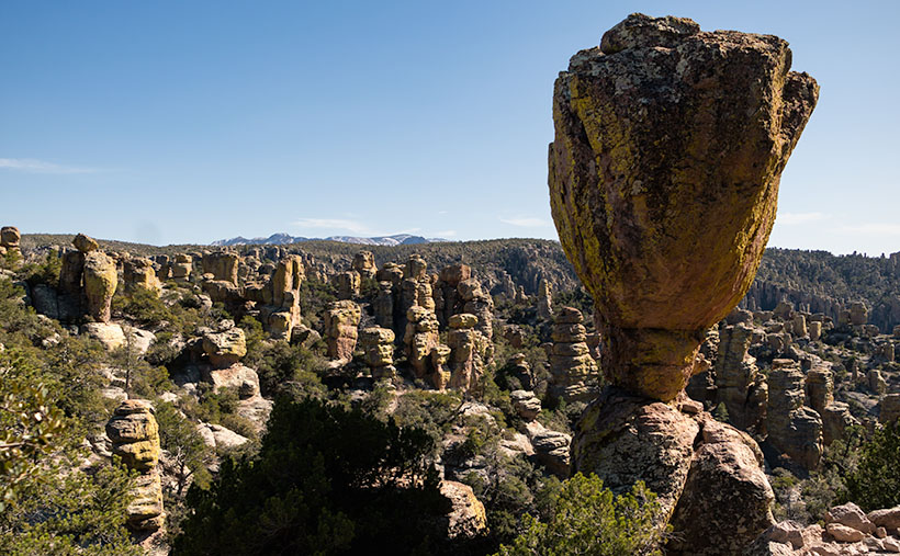
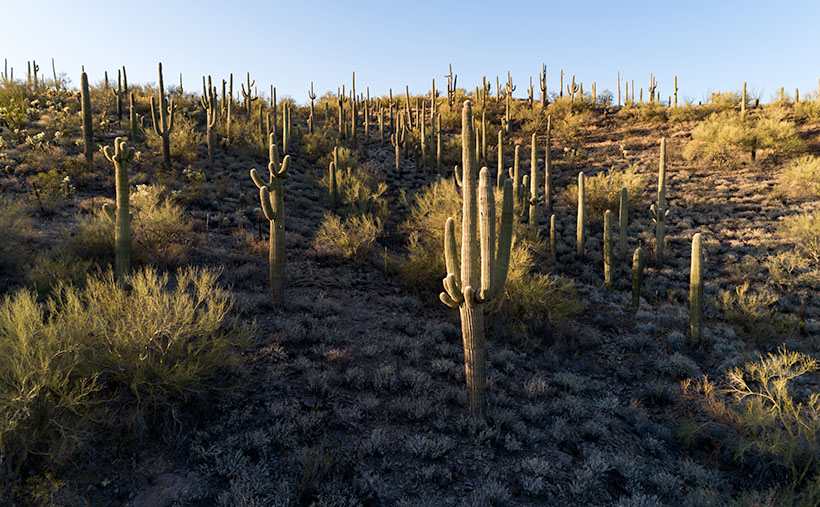
Over the past couple of weeks, we’ve been hiking and photographing the Grotto Trail in the Chiricahua National Monument. I know that seems like a long time for a one-mile trail, but I’m old and quickly fall. As you’ve seen in previous photos, massive rock formations that sometimes resemble sculptures line the track. That’s another reason the hike takes me so long—I can’t pass up these shots.

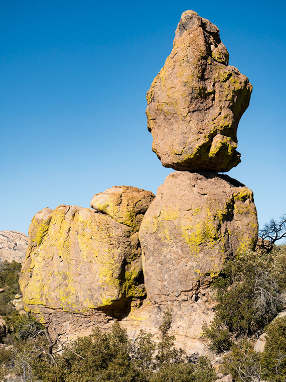
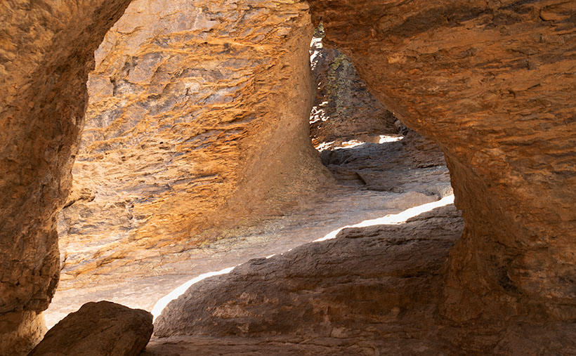
As I walked through the towering erosion formations, I wondered how the grotto would look. By definition, they’re a ‘picturesque cave,’ so I wasn’t sure what I was looking for. I shouldn’t have worried because, as that old proverb goes, “You’ll know it when you see it.” That’s precisely what happened. When I first peeked through a side window, I shouted, “Eureka, I’ve found it.”

It’s a cool room with light filtering in from outside. Four pillars line the room and hold up a slab of stone that fell on top. If you aren’t my size, you can crawl up inside and take a nap or play tea-time should you happen to bring your Barbie set. Because it’s open to the sky, you wouldn’t be able to take shelter from a storm like you’d be able to do in an actual cave.

Grotto From the Trail - When I looked back at the Grotto from the trail, I could see how it was assembled.
Grotto From the Trail – I could see how it is assembled when I looked back at the Grotto from the trail.

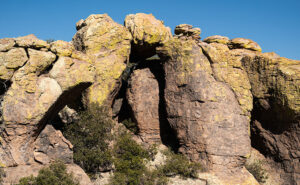
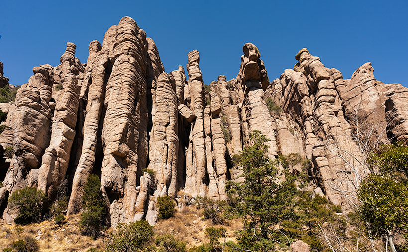
After catching my breath for a minute, I started back to the parking area. I was only a few steps down the road when I turned around and shot this second image. It gives you a better idea of how the Grotto is assembled, and quite frankly, it doesn’t seem to be a secret room—just an interesting pile of rocks. You can see a larger version of The Grotto on its Web Page by clicking here.

Since today is the last Sunday of the month, this is the end of April’s Chiricahua project. I took many more pictures, but I couldn’t show you all of them in only four weeks. If only there were another way for you to see them. Oh wait, there is.

Wrote a book about it—wanna see it?—here it is.

Chiricahua National Monument – My new photo essay of our trip to Cochise County will be available on Amazon, but you get a free preview because you’re a subscriber.


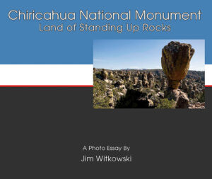
I’ve been working on a book while talking with you to prove that I can walk and chew gum. It’s the second in my sampler photo essay series. This one is called Chiricahua National Monument, and it includes the photos I’ve shown this month, plus a couple dozen more. Chapters in the book cover the Faraway Ranch, the hiking trails, and the landscapes surrounding the park.

It isn’t listed yet, but like my last book—Snow Canyon—it will be sold exclusively on Amazon at a ridiculous price of $68.00—unless you want to order a half-dozen or more, I can get a discount for you. Otherwise, no one will pay that price. But because you’re loyal readers, I devised a way for you to read the book and see my other photos—for free. I ordered a PDF version that you can open and download using this link: Chiricahua National Monument. PDF. You’re welcome to download it, print it, and toss it in the garbage when you’re done. I hope you enjoy it.

Next week is a new month, and we’re not entirely done with Cochise County. I found some pretty things to show you outside of the park, so come back next week when we begin May’s project.

Till Next Time

jw

Tulip Rock Picture of the Week

Tulip Rock - A formation that I passed on the Grotto Trail that looks like a tulip to me.
Tulip Rock – A formation I passed on the Grotto Trail that looks like a tulip to me.

One of my loyal readers commented that she couldn’t see the rock creatures like me. If you’re like her, that’s ok. Maybe your mind isn’t wound up like mine, or you’re not on the same prescriptions. Whatever the difference is, I’m simply trying to show you the world as I see it.

This week, I have another Rorschach test for you. It’s a picture of a second remarkable formation I found while hiking the Grotto Trail. I call it Tulip Rock because I think it looks like a flower. It could be a rosebud, a daisy, or a dew-covered morning poppy. Don’t see it? As long as you don’t see the Prince of Darkness who’s come to cast humanity into eternal damnation, you’re alright. If that were the case, I’d suggest you consider a change of meds.

When I composed this image, I wanted to show a couple of things. The first is that most of the hoodoos in Chiricahua don’t look like sculptures; they’re ordinary. That uniqueness makes the formations like this and last week even more special. I found two examples (there are more) on my short hike on the Grotto Trail. Imagine the images I’d have if I had visited the Chiricahuas as a younger man.

The other thing that I wanted to show is the background. The higher peaks of this range are along the horizon, including the 9700-foot Chiricahua Peak. As you can see in this image taken in late March, they are still snow-covered. They’re part of the Coronado National Forest—sometimes called the Sky Islands. The forest isn’t contiguous—it includes several southeastern ranges separated by broad basins. I’m not aware of another forest like it in the United States. Feel free to correct me if I’m wrong.

You can see a larger version of Tulip Rock on its Web Page by clicking here. Come back next week when we finally make it to the Grotto—a four-pillar room with a rock roof.

Jeff Goggin

It’s painful to type these words. Jeff Goggin—the other half of the Ballast Brothers Racing Team—died Thursday a week ago (7 April 2022). He was the last surviving family member and lived alone in the family’s Scottsdale home. Jeff’s mother lost a long degenerative battle with Lou Gehrig’s disease. It’s still untreatable. Several years ago, he told me that he was starting to show the same symptoms. Being the insanely practical man we knew, he ended his life to spare himself further suffering while he could still make his own decisions. Jeff is survived by his estranged partner, Paula Hoff.

Jeff was a brilliant, caring, funny man who loved good music, sick jokes, fast cars, fine art, a good scotch, and pretty women. Queen Anne and I miss the jerk.

Till Next Time

jw

Stoned Bunny Picture of the Week

Stoned Bunny - I admit that it's a stretch to see this rock as a rabbit, but Camelback Mountain's Praying Monk is obscure too.
Stoned Bunny – I admit that it’s a stretch to see this rock as a rabbit, but Camelback Mountain’s Praying Monk is obscure.

I love the park service’s pamphlets at the entrance gates. I collect them. In addition to a map, they show all the things to see and do inside the park. When I opened the one for Chiricahua National Monument and looked at all the trails, I thought it looked like a drunken pirate’s treasure map. There are trails on the straight and narrow; trials that go in circles, ones that climb mountains, while others descend into canyons.

Visitors don’t need to hike any of the trails. There are several parking areas where they can take in spectacular vistas. Heck, you don’t even need to get out of the car. However, if you want a genuine Chiricahua experience, you should venture out and walk among the formations. In the World of Rocks, features are hiding from the parking area. Even after all of my recent bellyaching about hiking, I found a short enough trail for me. It’s called the Grotto Trail, and it was pretty level and less than a mile round trip. I completed my tramp in less than 90 minutes, including my photography stops. Over the balance of this month, I will show you the trail’s highlights.

Do you remember several months ago when I wrote how the pixies build trail markers out of stacked rocks—called cairns? Well, there are no cairns in this monument. Using rock stacks to find your way through a park full of stacked rocks is useless. Cairns would be camouflaged. Instead, the WPA installed signposts at junctions and points along the way. How novel.

I found the balanced rock featured in this week’s post not far from the trailhead, so I shot it twice, once on the way out and again on my return. Calling the image Balanced Rock seemed dull because there are so many beside the trails. Then I’d have a series of photos named: balanced rock 1, balanced rock 2, etc. So, as I processed them, I tried to imagine what they resembled. If I close my left eye and stare at this image, it looks like a rabbit with his ears up and the face of Mr. Magoo. If I close my right eye, the image resembles a poorly crafted Easter Island statue.

Trying to decide, I stared at my computer and alternating eyelids when Queen Anne walked into the room, slapped me upside the head, and yelled, “Stop doing that. You’ll put your eye out, kid.” I was on the rabbit at the time, so that’s how it got its name—plus, I ate Stoned Rabbit at a fancy Italian restaurant once; it tasted like chicken.

You can see a larger version of Stoned Bunny on its Web Page by clicking here. Next week I’ll show you another shot that I took on the way to the Grotto. Be sure to come back and take part in the fun.

Till Next Time

jw


Organ Pipes Picture of the Week

Organ Pipes - One of the first features you see after entering the park is the Organ Pipe Formation.
Organ Pipes – One of the first features you see after entering the park is the Organ Pipe Formation.

Two days have passed since April Fool’s day on Friday. That morning, Queen Anne stopped by my office door and announced, “I’m pregnant.” She’s a one-trick pony because she’s recycled that joke every year that we’ve been married, so I ignored her. However, Friday was an important milestone for me, and since I’ve waited two days, you know I’m not pulling your leg. Friday marks the 50th year since I moved to Arizona. I think that officially makes me overqualified to be a native.

With the month’s change, we’re starting a new project. April Fool’s—we’re not leaving Willcox. I’m just going to show you why we actually traveled to Cochise County and what we did with our afternoons. You’ll recall that I spent mornings in Willcox searching for a decent cup of coffee and shooting the town’s historic buildings. After an hour or so—when the light became too harsh—when I returned to our motel and opened the door, Queen Anne sat on the bed corner bejeweled and makeup finished. “I’m ready for breakfast,” she’d say—who am I kidding? That would never happen. The truth is that I could hear her lyrical voice waft from the bathroom, “I’ll be ready in a minute.” In husband-speak, that phrase meant that I had time for a nap.

The actual purpose of our Willcox visit was to photograph the Chiricahua National Monument. After fifty years of living in Arizona, this was my first visit. It’s usually a half-hour drive southeast of Willcox. Still, we dawdled with a camera and stretched the trip to over an hour. The scenery along County Road 186 reminded me of California’s central valley and the Sierra Nevada foothills. Long butterscotch colored grass filled the broad Sulphur Springs Valley between the Dos Cabezas Mountains (Two Heads in English) on our east to the Dragoons on our west. Arizona ranges don’t tower over its valleys as the Sierra’s do, but at least the air was clear, and we could see all of the mountains.

My After Life - I found out that I can become a rural mail carrier in Cochise County even after I'm dead. That gives me something to do after I'm gone.
My After Life – I learned that I could become a rural mail carrier in Cochise County even after I’m dead. That gives me something to do after I’m gone.

On one of the many photo stops that we made, I was able to chat with the local postal carrier and got some great news. He told me that I don’t have to be useless after my death because I can always get a job delivering mail for eternity. You saw my after-life job delivering mail if you watched Funny Farmthe movie. All I have to do to qualify is pass the Civil Service Exam.

The route coming out of Willcox ends at the Junction of county roads 186 and 181, and you turn east on the latter. You pass from open range into a canyon as you head into the Chiricahuas. Within four miles, there’s a pay station. It’s closed due to the pandemic, so the Rangers collect any fees at the visitor’s center. Immediately on the right is a small family cemetery where the Erickson’s rest under shady oak trees. The Erickson’s are the family that homesteaded here after he retired from the Army at Fort Bowie. They established a ranch along Bonita Creek called Faraway Ranch because it’s far away from anything. Their daughter, Lillian, and her husband, Ed Riggs, welcomed guests to the homestead to promote tourism. They built many of the trails still in use, allowing visitors to wander among the unusual columns of eroded stone.

There’s only a single road in the monument that runs from the entrance, past the visitor’s center, climbs through Bonita Creek Canyon, and winds along the ridge of the park’s eastern boundary. Along its length, there are numerous stops, pull-outs, and parking areas where you can stop and take in the view, like this week’s picture that I call Organ Pipes. However, if you want to immerse yourself in the complete gestalt, you should plan on hiking one of the trails. They range from a half-mile to a couple of miles long. You can also link several trails and make your feet suffer to your heat’s delight.

Chiricahua National Monument only has one small campground, which fills quickly—especially during the season. There are only two towns with hotels, Willcox along Interstate 10 and Douglas at the Mexican border if you’re willing to drive further.

The Organ Pipe Formation captured in this week’s image is one of the first displays after the visitor’s center. The columns rise several hundred feet above Bonita Creek and are mirrored on the other side of the road by similar rocks. There wasn’t a way for me to hike above the trees to get a better shot. This picture does not do justice to their scale.

You can see a larger version of Organ Pipes on its Web Page by clicking here. Next week we will hike one of the short trails to look at the park’s natural sculptures. Come back to see what we found.

Until next time — jw


Saguaro Bouquet Picture of the Week

We’ve spent March exploring the Black Hills—an interesting group of low mountains on Wickenburg’s north side that gets their name from the dark surface crust on their top. I was able to shoot them from different perspectives by driving the old mine roads that my SUV—Archie—could navigate easily. While I’m out jaunting about and looking for different angles of my subject, I try to keep an eye out for other good scenes—and that’s the case with this week’s featured image.

When I drove out Rincon Road a couple of weeks ago, I intended to get the shot Black Hills—last week’s featured image. While I was there, I discovered a hill covered with saguaro. As I’ve written before, saguaro does well on a south-facing well-drained slope, and when I see a stand like this, it makes me happy. This is a healthy forest. Since I’d already invested the time driving out there, I also took this shot.

Saguaro Bouquet-A small but dense grove of saguaro growing on a hillside near Wickenburg, Arizona.
Saguaro Bouquet-A small but a dense grove of saguaro growing on a hillside near Wickenburg, Arizona.

I named this week’s image Saguaro Bouquet jokingly because—although they each weigh a couple of tons—it looks like you could pick them for a Mother’s Day bouquet (hey, no one said I was normal). Although this grove is small, it’s densely packed along the hillside.

There are some other things I see in the photo. It was still winter when I took it, but the scene will change dramatically as the weather warms next month. For example, the little gray bushes covering the ground are brittlebush. In a couple of weeks, they will sprout yellow daisy-like flowers. Shortly after that, the palo verde trees will start flowering, adding more yellow. Finally, in May, the saguaro will be adorned with large white blossoms. That’s an Arizona Highways kind of picture. If you’d like to see it yourself, ask me, and I’ll give you the map coordinates.

I am happy you took the time to view my new photo. You can see a larger version on its Web Page by clicking here. Be sure to come back next week for a complete change of pace. I promise that for April, there won’t be a single saguaro.

Until next time — jw

Fish-Hook Barrel Cactus Picture of the Week

When you hear someone talk about a desert, what image pops into your mind? Is it the endless Sahara dunes where Bedouins in keffiyeh headdress travel by camels? Maybe it’s the barren, dry lakes of Death Valley, or perhaps your go-to desert is in Mongolia. By definition, a desert is any place receiving less than 20 inches of annual precipitation. That makes most of the Great Plains, most of Southern California, and the Antarctic deserts.

My desert is the one that I’ve called home for almost 50 years; the Sonoran Desert. In the last half-century, I’ve traveled most of its parts within Arizona and California. I can attest that it’s not a flat, uniform wasteland—as some people think. It has mountains, canyons, plains, dry washes, and an exotic river or two. Its span ranges between Arizona and the Mexican State of Sonora. If you see a map of it (and you have to squint real hard), it’s jellyfish shaped—starting at the north (where I live), the half-circle body covers Arizona, and the tentacles reach south to either side of the Sea of Cortez. Its width covers from El Centro to Tucson.

The signpost that says, “This is the Sonoran Desert,” is the saguaro cactus. It thrives here because of the four major western deserts; the Sonoran is the only one with two rainy seasons; winter rains and summer monsoons. In winter, the rains nourish the cactus to flower and bloom, while the monsoons provide water for the dispersed seeds to germinate. Isn’t nature swell?

Although the saguaro may be the Sonora’s big-ticket item, it isn’t the only thing here to see. That’s evident when you visit the desert’s reserves like Saguaro National Park, Organ Pipe Cactus National Monument, KOFA Wildlife Preserve, or several wilderness areas in southern Arizona. The biodiversity of these places will keep you on your toes—“Watch out! There’s a snake over there.”

Fish-hook Barrel Cactus - a couple of succulents nuzzle in the late afternoon sun.
Fish-hook Barrel Cactus – a couple of succulents nuzzle in the late afternoon sun.

That’s how I thought I’d end our one-day tour of Saguaro National Park. While exploring the park’s dirt road loop, I spotted a couple of succulents nuzzling one another, so I went in and grabbed a shot. I call this picture Fish-hook Barrel Cactus. It shows a couple of common cacti—a fish-hook barrel and prickly pear—glowing in the evening sun. The barrel cactus is the one you’re supposed to cut open if you need water—it’s not hollow, so you have to wring the pulp if you’re desperate for a bad tasting drink. Prickly Pear grows everywhere and has even overrun Australia after it was illegally transplanted there.

You can see a larger version of Fish-hook on its Web Page by clicking here. For December, we have an idea for a completely different type of monthly project. We had to. I’ll be spending time with my Mexican dentist—oh joy—and Anne is risking her life to visit her family. She’s shortening my leash while she’s away, so I won’t be able to roam very far from home. If I do, my electronic collar will shock me.

Until next time — jw

Get Bent Picture of the Week

Not all saguaros are super-models. Like people, they come with all sorts of warts and scars. The Gila woodpeckers carve nests in them because inside the flesh, the summer daytime temperatures can be over thirty degrees cooler than outside. The cavities don’t cause harm to the saguaro, and squatters like hawks, owls, and other birds move in after the woodpeckers leave. The substantial threats to a saguaro’s life are from lightning, strong winds, stupid people, but the real culprit is frost.

On our imaginary day-trip around Saguaro National Park, we’ve left behind the visitor center, and we’re exploring the Bajada Wash Loop, which leads from the west side up toward the Tucson Mountains—the park’s backbone. In fact, these are the only roads into the interior. Countless trails crisscross the park, and they appear to be the preferred method of exploring the backcountry. I’ll leave that mode of transportation to people younger and more agile than me.

Get Bent - A frost damaged saguaro rises above a thicket of palo verde before the Tucson Mountains.
Get Bent – A frost-damaged saguaro rises above a thicket of palo verde before the Tucson Mountains.

The afternoon was getting late when we reach the top of the loop. The shadows were already long as I looked for a shot of the range’s high peaks. I stopped the truck when I spotted an interesting cactus. It rose maybe thirty-feet above the top of a palo verde thicket, and it had a bent trunk. I guessed the deformity was the result of a freeze. It’s a young specimen—if you can consider thirty-years young—to have damage like this, but the Tucson Basin is a thousand-feet higher than Phoenix, and we were near the top of the loop, which is 500-600 feet above the city. That’s near the limits of the saguaro’s range because winter nights often get below freezing up here.

After I processed this shot and began pouring over area maps,  I realized that I also captured another landmark in it—actually two of them. To the saguaro’s left are two peaks on the horizon. The taller of them is Wasson Peak (4639′), and the other is Amole Peak (4386′). They are the two highest points within the park’s boundaries. So, this week you get a BOGO.

You can see a larger version of Get Bent on its Web Page by clicking here. Next week, our day in Saguaro National Park comes to an end, so be sure to come back and see what we found.

BTW: Queen Anne and I wish you a very safe and happy Thanksgiving. We’ll be spending the day at home enjoying store-bought leftovers. You know, the usual turkey, stuffing, mashed potatoes swimming in gravy, cranberry sauce molded in the shape of a can, and buttermilk pie topped with fruit and whipped cream. I’ll see you next week if I can get up from the couch.

Until next time — jw