Cottonwood Grove Picture of the Week

I want to begin this week’s post by thanking Deb Poteet for her advice about wearing fish-net stockings. If you missed what she said, it was a helpful comment to last week’s post. She said that she got her information straight from the Candy Store dancers—the gentlemen’s club on Cave Creek Road near Costco. It made both Queen Anne and me wonder what she was doing hanging around old strip clubs. Deb really does surprise us sometimes.

On another subject, Her Majesty is improving with each day. She goes to physical therapy three times a week and limps around the house without her walker or a cane. When I remind her that she doesn’t need to do that, she drops the Chester impersonation. It’s interesting to see how fast a woman can recover when you walk up to her death bed with a bottle of Dawn dish detergent and ask, “How much of this do I put in the dryer?”
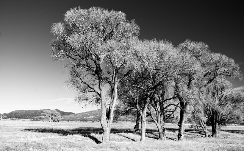
Cottonwood Grove - A small grove of cottonwood grow along a dry brook in Peeples Valley, Arizona.
Cottonwood Grove – A small grove of cottonwood grows along a dry brook in Peeples Valley, Arizona.

Meanwhile, back up the mountain in Peeples Valley, and the second in my series of cottonwood tree images. This week’s featured image that I call Cottonwood Grove was another image taken on the Maughan Ranch north of town. Like other members of the Poplar family, these large fast-growing trees only grow where there’s a good water supply. In this image, there’s about a half dozen growing along the banks of a dry brook, which eventually feeds Kirkland Creek. Scenes like this one are familiar throughout the west.

In an Arizona Geography class that I took at Arizona State University, the professor told us how the trees filled the length of the Salt River bed. A family of beavers dammed the river under the Mill Avenue Bridge while the river still flowed. When the Corps of Engineers built the dams east of town, the Salt River stopped flowing, and the trees died, rotted, and eventually, a summer monsoon storm blew them over. That would have been a swell topic for a photo essay, but I wasn’t here then.

You can see a larger version of Cottonwood Grove on its Web Page by clicking here. I hope you like it. Be sure to come back next week for another cottonwood portrait from Peeples Valley.

Until next time — jw

Mount Tipton Wilderness Picture of the Week

Since our trip to Pearce Ferry, I’ve written about the Grand Wash Cliffs, and rightly so. Last week, I mentioned that they formed the western edge of the Colorado Plateau and that the great river bisects the cliffs. But the Hualapai Valley has another mountain range on its west flank, and they’re the Cerbat Mountains. They fill the 23 miles between Kingman and Dolan Springs. On the drive to Las Vegas on US 93, they’re to the east side of the highway as you travel north through the Detrital Valley.

There are some old mines located in the Cerbats; Cerbat, Mineral Park, and Chloride. Traveling north from Kingman, you first pass the ghost town of Cerbat, which is hidden at the end of a challenging (4wd) road. The next is Mineral Park, which is due east of Santa Clause (that’s another story unto itself). Finally, the biggest one is Chloride—whose tailings are visible from Highway 93. I think Chloride is still active, but I don’t know for what they’re digging.

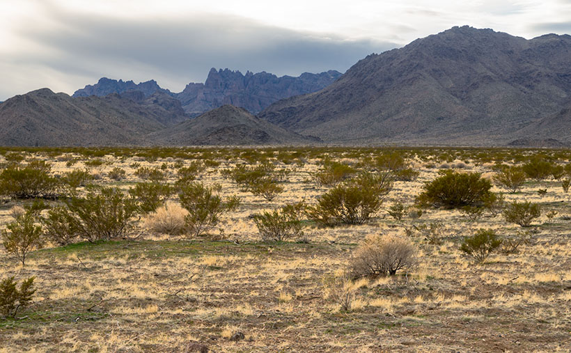
Mt. Tipton Wilderness Area - The jagged peaks in the Mt. Tipton Wilderness Area are at the north end of the Cerbat Mountain Range.
Mt. Tipton Wilderness Area – The jagged peaks in the Mt. Tipton Wilderness Area is at the north end of the Cerbat Mountain Range.

More interesting to me is the Mount Tipton Wilderness Area, which is almost at the northern end of the Cerbat Range. At 7148 Mt. Tipton is the tallest peak, but the wilderness area also has some jagged peaks that made me stop to take this week’s featured image—even though the sun had gone behind the looming storm clouds. I named the photo Mt. Tipton Wilderness, and it shows dried grasses and creosote bush against the barren granite mountains.

On the whole, I enjoyed our drive to Pearce Ferry. There were a lot of beautiful sights found there, and I can see returning in the future to do more serious photography. That’s the downside of these trips. They’re to photography what Cliff Notes are to books. To get the best results, you need to study and understand the subject.

On the other hand, we’ve only begun to explore Arizona’s back roads, and there’s so much more to see. I feel like I wasted the first two-thirds of my adulthood working for a paycheck. However, I understand that I wouldn’t be here if I hadn’t. I hope I have enough time to finish it all.

You can see a larger version of Mt. Tipton Wilderness on its Web Page by clicking here. I hope you enjoy seeing it. Next week I have a surprise for you. Something completely different, so I hope we’ll see you then.

Until next time — jw

Garnet Mountain Picture of the Week

When I was a younger man, I had too many hobbies. Besides photography, I raced cars, fished, listened to music, and gorged on food and wine. Since retiring, we’ve downsized. I’ve given up cars, fishing, and expensive restaurants. We live on a pension now, so photography is my last indulgence—and it’s a good thing that I don’t have to buy film anymore, else I’d have to throw that out the window too.

It took a while to adapt to Arizona living. Sure, half the year is divine, but summers are hell—literally. So, as every good Zonie knows, you head for the hills to escape the heat and humidity of the monsoons. The other option is to close the drapes, lock the doors, and hibernate in front of the telly. As an aspiring angler, I bought a new edition of Bob Hirsch’s Best 100 Arizona Fishing Holes every year. They never changed, but I always read the ink off my copy by the time the Outdoors Show rolled around. I preferred fishing for trout instead of bass, so we’d make our pilgrimages to where the waters were cold: the Mogollon Rim, White Mountains, Lake Powell, or Lee’s Ferry—if the weather was good.

On the trip that Queen Anne and I made to Pierce Ferry for this month’s topic, I kept asking myself, “Why haven’t I been here before? This part of Arizona is beautiful and very photogenic.” I think the simple answer is that there are no trout here, so I didn’t care. Of course, there’s the Black Canyon below Hoover Dam, but it’s 675′ above sea level. That’s lower than Phoenix, and black rocks surround it. Besides, I got skunked on the one trip that we made, so I never went back.

Hualapai Valley, as I said, is Basin-and-Range topography—like Nevada. It’s flanked on the east by the southern end of the Grand Wash Cliffs, while the Cerbat Mountains line the west. The valley floor’s low spot is Red Lake—which is dry most of the year. Orchards surround the lake, but I don’t know how successful they are. Hualapai Valley is also home to a large grove of Joshua Trees, which fills an area about the same size as ours in Yavapai County.

It’s the Grand Wash Cliffs that caught my attention on the map. They’re a long string of mountains—above and below the Colorado River, forming the western edge of the Colorado Plateau. They’re the transition to the Great Basin Desert.

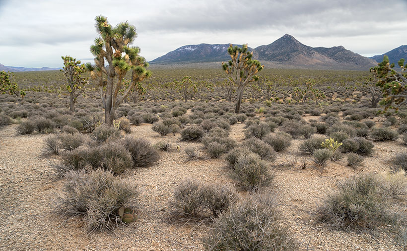
Garnet Mountain - Joshua and sage grow to the foot of snow-covered Garnet Mountain.
Garnet Mountain – Joshua and sage grow to the foot of snow-covered Garnet Mountain.

This week’s featured image, Garnet Mountain, shows Joshua Trees and sage growing to the mountain’s feet. The mountain is over 6,000 ft high and has snow from previous winter storms. The unnamed pointy peak is closer but a thousand feet shorter, so that’s why it’s not snow-capped. Together, they show two of the geological forces that shaped Arizona. Block shapes are generally uplifts caused by plate tectonics, while pointy mountains are usually volcanic. I like what we saw on this visit, so I’m planning a trip to the Colorado River’s north side later this year, but to do that, I’ll need to travel via Utah or Nevada, so I’ll need some slot machine money.

You can see a larger version of Garnet Mountain on its Web Page by clicking here. I hope you enjoy seeing it. Join us next week as we drive home and stop for more photos.

Until next time — jw

Cholla Bay Picture of the Week

After being stopped by a river that rarely has flowing water, we spent some time along the bank of the Big Sandy, watching the calm, almost clear water flowing on its way to Alamo Lake. Queen Anne broke out a couple of water bottles, and we shared a trail bar while perusing the map to find our options.

This would have been a perfect picnic spot if we had packed a basket. Imagine sitting on a blanket in the middle of 17 Mile Drive, where it disappears beneath a river. We could see a couple of houses nearby, and later, I found out that we were in Greenwood—the site of yet another abandoned mining community. In its heyday, some three hundred souls lived and worked here. The town—named after the abundance of Palo Verde trees—didn’t last long because of its low-quality ore.

We turned around and started our journey home with the day getting late. We dallied along the way, making many stops for photos. Before the road began the ascent up the mountain, I spotted where the Big Sandy River had scoured 30-foot cliffs out of the mud banks. The formation was nearly circular, and you could imagine the raging water churning in a back eddy, a swirling whirlpool flowing against the river’s current. A large grove of Teddy Bear Cholla was growing inside the containment, so I grabbed my camera and hiked in for a shot.

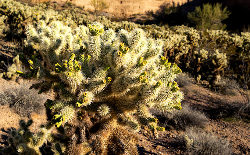
Cholla Bay - The most dangerous cactus will attack you at the slightest provocation.
Cholla Bay – The most dangerous cactus will attack you at the slightest provocation.

I have a love/hate relationship with the cholla cactus. When backlit, it has a soft fuzzy look that makes you want to jump into it like a pile of autumn leaves. It’s also known as Jumping Cholla, but it doesn’t do that. Its outer joints are fragile—hair trigger, if you will—and the tips break off from the main plant with the slightest disturbance. The needles are barbed, so if you get some into your skin, you have to pull them out with pliers—one by one.

Whenever I’m near Cholla, I move slowly and cautiously. I watch the ground for snakes, cow pies, and cholla balls. It’s like walking a tight wire. I don’t look up until I stop walking. So imagine how startled I was in the middle of this field when a wild gray burro popped his head up and snorted. He was just as frightened as I was and quickly galloped off to the far side of the road, but it took all my self-control not to stumble back through the cactus patch. Once the two jackasses safely separated, I regained my composure and took this picture, which I called Cholla Bay.

You can see a larger version of Cholla Bay on its Web Page by clicking here. I hope you enjoy viewing it. Join us next week when we finish our trip to the Poachie Mountains.

Until next time — jw

Greenwood Peak Picture of the Week

I have two reasons for these monthly jaunts on Arizona roads I’ve never traveled. The first is to give me a reason to get out and shoot. The other purpose is to force me to explore places I haven’t seen, see what’s out there, and see what I haven’t seen.

What was new to me on this trip was seeing saguaro growing among the Juniper. Think about it. The mix of those two plants never happens. The saguaro stops growing at about 3000 feet because they don’t tolerate frost. To be in a field of Juniper, you’d have to travel to Sedona, Prescott, or Payson. I yammered on and on about this phenomenon, Anne, as 17 Mile Road twisted up into the Poachie Range. At one point, I was so confused that I stopped and pulled out my Garmin to check the elevation.

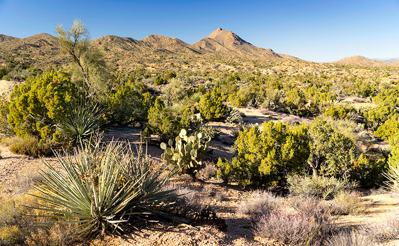
Greenwood Peak - One of the two prominent peaks in the Poachie Mountain Range. This one can be seen if you travel through Wikieup.
Greenwood Peak – One of the two prominent peaks in the Poachie Mountain Range. Greenwood Peak can be seen on the western horizon if you travel to Wikieup.

The Poachie Range is 30 miles long, and you see them west of U.S. 93 between Nothing and Wikieup. They’re not very tall, with its tallest peak being Arrastra Mountain at 4807 feet. So, I usually wouldn’t expect to see Juniper this low. When I checked my GPS, the elevation was 3600 Feet. All this leads me to believe that winters aren’t severe here, but more rain falls here than on the desert floors. Anyway, that’s my story, and I’m sticking to it.

The road we traveled crossed the Poachie Range south of its prominent northern peak—Greenwood Peak. It’s the subject of this week’s featured image. It only rises to an altitude of 4300 feet, but it still provides a handsome backdrop for the unusual mixture of cactus and evergreens.

You can see a larger version of Greenwood Peak on its Web Page by clicking here. I hope you enjoy viewing it. Join us next week as we finish our trip to the Harquahala Mountains.

Until next time — jw